Marine Area Rules & Definitions
Season and Daily Hours:
During an open season, marine waters are open 24 hours per day, except as noted for night closures.
Quota Management:
Salmon, halibut, and some shellfish are managed by quotas in many marine areas. These fisheries close when the quotas have been taken. Closures will be announced to local news media and will be included in the Fishing Hotline and Shellfish Rule Change Hotline messages.
Check for Emergency Rules:
Emergency rules may occur throughout the year and will supersede the rules contained in this pamphlet. Changes can be found by calling the WDFW Fishing Hotline (360) 902-2500 or Shellfish Rule Change Hotline (866) 880-5431, contacting statewide customer service (360) 902-2700, or by visiting the WDFW website
Rules listed below are General Rules.
In Washington waters where a saltwater license is valid, each angler aboard a vessel may continue to deploy angling gear or shellfish gear until the daily limit of fish and shellfish for all anglers aboard has been achieved.
Special Rules
Hatchery Steelhead – May be caught and released until the daily limit is retained. If a fish has swallowed the hook or is hooked in the gill, eye, or tongue, it should be kept if legal to do so. Wild steelhead must be released.
Salmon – Single-point barbless hooks and a hand-held rod and line must be used.
In Areas 5-13, it is illegal to bring a wild salmon or a species of salmon aboard a vessel if it is unlawful to retain those salmon. "Aboard a vessel" is defined as inside the gunwale. Also see special Handling Rule for Area 2-2 east of the buoy 13 line.
White Sturgeon – Only one single-point barbless hook and bait is allowed when fishing for sturgeon. Catch-and-release only. Open year-round. Night closure in effect. Sturgeon over 55" fork length cannot be removed totally or in part from the water.
Green Sturgeon – It is unlawful to fish for or retain green sturgeon.
Halibut – Hook and line angling and spearfishing only. A hand-held line is permitted. Only one line with up to two hooks may be used. Halibut may be shot or harpooned while landing. It is unlawful to fish for, retain, possess, or land halibut into a port located within an area that is closed to halibut fishing, except it is lawful to land halibut into a port within Marine Area 4, that were lawfully retained in Marine Area 5.
Bottomfish, Tuna, and Mackerel – Hook and line angling, spearfishing, and bow and arrow fishing only. May not retain, possess, or land bottomfish from Oregon that do not comply with the regulations for the area where the fish are landed. See bottomfish definition on Definitions.
Rockfish – It is unlawful to fish for, retain, or possess yelloweye rockfish in all Marine Areas. It is unlawful to fish for, retain, or possess rockfish in Areas 6-13.
Forage Fish – Forage fish jig or forage fish dip net only except anchovy and sardine may be taken by a cast net in Areas 1-4. Only one net may be used at a time. Dip net gear must be held by the rigid handle at all times and may not be used from a vessel while under power. Cast net gear must be in immediate control at all times with retrieval cord in hand. Anglers with the reduced-fee license or a Designated Harvester Card may use a forage fish dip net with a hand-operated gate. Jig gear may have up to three treble hooks or nine single-point hooks, not to exceed 3/8" between point and shank. While fishing in Areas 5-11 & 13, a second line using forage fish jig gear may be used to fish for forage fish.
You may use forage fish jig gear in Columbia River waters from the Buoy 10 line to the Rocky Point/Tongue Point line.
Unclassified Marine Fish – Closed
Other Food Fish – See Definitions. Daily limit is 2 of each species.
Shark closure – Closed to fishing for, retention, or possession of sixgill, sevengill, and thresher sharks. Sixgill shark may not be removed from the water.
Possession Limits
Vessel Limits Marine areas 1-6: Anglers aboard a boat may only possess one daily limit of fish or shellfish in fresh form.
Salmon – Two daily limits of fresh salmon, except 1 daily limit when aboard a vessel in Marine areas 1-6. An additional 40 pounds of salmon may be possessed in a frozen or processed form (see Definitions).
Steelhead – Two daily limits of hatchery steelhead, except 1 daily limit when aboard a vessel in Marine areas 1-6.
Bottomfish – Two daily limits in any form, except 1 daily limit when aboard a vessel in Marine areas 1-6.
Halibut – Two daily limits in any form, except only one limit while aboard a fishing vessel. Annual limit is 4.
For halibut caught in Canadian waters, contact Department of Fisheries and Oceans Canada (DFO) or visit their website at
Tuna – Albacore, and mackerel - No possession limit or daily limit. Yellowfin, skipjack, and Northern bluefin - No possession limit, daily limit 2 each, except possession limit of 1 daily limit when aboard a vessel in Marine areas 1-6.
Shellfish – One daily limit of fresh shellfish. Additional shellfish may be possessed in a frozen or processed form. See Marine Area 12 for Shellfish/Seaweed rules and Shellfish Safety Information.
Forage Fish (herring, anchovies, sardines, sand lance, and smelt) – Two daily limits in fresh form, except 1 daily limit when aboard a vessel in Marine areas 1-6. Additional forage fish may be possessed in frozen or processed form. Closed to fishing for eulachon (Columbia River smelt). Each smelt harvester must use a separate container to hold their catch and the container must be in the harvester's presence or identified with the harvester's name.
Tackle/Gear Rules
All Fishing Gear - Must be kept in immediate control, and gear may not be left unattended while fishing.
Hook and Line Angling – Unless noted differently, only one line with up to 2 hooks is allowed.
Barbless Hooks – are required for all species in Marine Areas 5-13, except forage fish jig gear. When fishing for salmon in Areas 1-13, single-point barbless hooks must be used.
Descending Device – A device used for the rapid descent or recompression of fish. A descending device must be onboard vessels and rigged for immediate use when fishing for or possessing halibut or bottomfish. See
Forage Fish Dipnet - A section of netting (maximum mesh size is 5/8" stretched mesh) distended by a rigid frame not exceeding 36" across and directly attached to a rigid handle. May only be used for forage fish or squid.
Forage Fish Cast Net - A section of netting (maximum mesh size is 1" stretched mesh) no larger than 10' in diameter with retrieval cord. May only be used in Marine Areas 1-4, and may only be used for harvesting anchovy and sardine.
Landing a Fish - A club or dipnet (landing net) may be used to assist landing a legal fish taken by legal gear. A gaff may only be used to land a legally hooked lingcod (in Marine Areas 1-3 and 4 West of Bonilla-Tatoosh line), halibut, tuna, or dogfish shark that will be retained. Halibut may be shot or harpooned while landing.
Downriggers - May be used with a line if the line releases from the downrigger while playing and landing the fish.
Rodholders - May be used; the rod must be easily removed without delay; rod may be left in the holder while playing the fish.
Electric Reels - May be used if designed for sport fishing and attached to a fishing rod.
Spearfishing - The diver must be swimming or floating in the water while spearfishing. The use of explosives or bullets attached to the spear ("bang sticks") is prohibited.

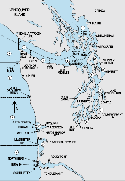
Area Definitions and Codes
1. - Ilwaco – west of the Buoy 10 line at the Columbia River mouth, north to Leadbetter Point.
2. - Westport-Ocean Shores – from Leadbetter Point north to the Queets River, excluding Willapa Bay and Grays Harbor.
2-1. - Willapa Bay – east of a line from Leadbetter Point to Cape Shoalwater (see definition on Marine Area 2).
2-2. - Grays Harbor – east of a line from the outermoust tip of the north jetty to outermost exposed end of the south jetty.
3. - La Push – from the Queets River (47°32.31'N) north to Cape Alava (48° 10' N).
4. - Neah Bay – from Cape Alava north and inside Juan de Fuca Strait to the Sekiu River.
5. - Sekiu and Pillar Point – from mouth of the Sekiu River east to Low Point, mouth of the Lyre River.
6. - East Juan De Fuca Strait – from Low Point east to the Partridge Point – Point Wilson line, north to the line from Trial Island (near Victoria B.C.) – Vessel Traffic Separation Buoy "R" – Smith Island to the Lawson Reef Buoy, to Northwest Island, to the Initiative 77 marker on Fidalgo Island.
7. - San Juan Islands – all marine waters north of the Trial Island line (described under Area 6) to the United States-Canada boundary.
8-1. - Deception Pass, Hope Island, and Skagit Bay – from West Point to Reservation Head eastward through Deception Pass, including all waters of Swinomish Slough and Skagit Bay, and the portion of Saratoga Passage north and west of a line from East Point Light to light on Camano Island (Saratoga Pass Light #4Fl Red 4 Sec.).
8-2. - Ports Susan and Gardner – east of East Point Light-Camano Island Light line (described in 8-1 above) and north of the Possession Point-Shipwreck line (described in 9 below).
9. - Admiralty Inlet – all waters inside and south of the Partridge Point – Point Wilson line, south and west of a line from Possession Point 110° true to shipwreck, north of the Hood Canal Bridge, and north of the Apple Cove Point-Edwards Point line.
10. - Seattle-Bremerton Area – south from the Apple Cove Point-Edwards Point line to a line projected true east- west through the north tip of Vashon Island.
11. - Tacoma-Vashon Island – south from a line projected true east west through the north tip of Vashon Island to the northernmost Tacoma Narrows Bridge.
12. - Hood Canal – all waters south of the Hood Canal Bridge.
13. - South Puget Sound – all waters south of northernmost Tacoma Narrows Bridge.

