Marine Area 5
(From mouth of the Sekiu River east to Low Point, mouth of the Lyre River) See map on following page.
Species |
Season |
Additional Rules |
Trout |
Year-round |
Catch-and-release. |
Steelhead |
Year-round |
Daily limit 2 hatchery steelhead. |
Sturgeon |
Year-round |
Catch-and-release. |
Tuna and Mackerel |
Year-round |
No min. size. No daily limit except Northern bluefin, skipjack, and yellowfin tuna daily limit of 2 each. |
Herring, Anchovy, Sardine, Sand Lance, and Smelt |
Year-round |
No min. size. Daily limit 10 lbs., all species combined. All smelt caught must be kept and count toward the daily limit except Closed to eulachon (Columbia River smelt). For smelt: Jig gear may be used 7 days a week. Dipnets may be used from 6:00 a.m. until 10:00 p.m. Fridays through Tuesdays. |
Pacific Halibut |
Check the WDFW website at |
|
Other Food Fish |
Year-round |
No min. size. Daily limit 2 of each species. See Definitions. |
All Other Fish |
CLOSED |
CLOSED to fishing for, retaining, or possessing. |
Salmon |
||
| Entire Area (See 5) |
July 1-Aug. 15 |
Chinook - min. size 22”. Other salmon species - no min. size. Daily limit 2 including no more than 1 Chinook. Release chum, wild coho, and wild Chinook. Kydaka Point Area Closed. See Kydaka Point Area and map next page. |
Aug. 16-Sept. 30 |
No min. size. Daily limit 2. Release Chinook, chum, and wild coho. Kydaka Point Area Closed. See Kydaka Point Area and map next page. |
|
Oct. 1-Oct. 15 |
No min. size. Daily limit 2. Release Chinook and chum. |
|
Oct. 16-Mar. 31 |
CLOSED |
|
Apr. 1-Apr. 30 |
Chinook - min. size 22”. Other salmon species - no min. size. Daily limit 2 including no more than 1 Chinook. Release coho, chum, and wild Chinook. |
|
Bottomfish |
||
Year-round season. Daily limit is a total of 15 bottomfish (see Definitions) subject to individual limits and seasons shown below. Fishing for or possession of bottomfish is prohibited seaward of a line approximating 120’ (see Bottomfish Closure coordinates below). Exception: when lingcod and halibut seasons are both open, retention of lingcod and Pacific cod is allowed in waters deeper than 120’. Descending device required onboard vessels. |
||
Lingcod |
May 1-June 15 |
Hook and line season. Min. size 26”. Max. size 36”. Daily limit 1. See Bottomfish Closure below |
May 21-June 15 |
Spearfishing season. Max. size 36”. Daily limit 1. |
|
Surfperch |
Year-round |
No min. size. Daily limit 10. Except shiner perch daily limit 15: not included in bottomfish limit. |
Rockfish |
||
West of Slip Point |
May 1-Sept. 30 |
No min. size. Daily limit is the first 3 black or blue/deacon rockfish caught. See Bottomfish Closure below |
May 1-June 15 |
Spearfishing season. No min. size. Daily limit is the first 3 black or blue/deacon rockfish caught. See Bottomfish Closure below |
|
East of Slip Point |
May 1-Sept. 30 |
No min. size. Daily limit is the first black or blue/deacon rockfish caught. See Bottomfish Closure below |
May 1-June 15 |
Spearfishing season. No min. size. Daily limit is the first black or blue/deacon rockfish caught. See Bottomfish Closure below |
|
Pacific Cod, Pollock, Hake |
Year-round |
No min. size. Daily limit 2 of each species. See Bottomfish Closure below |
Cabezon |
May 1-Nov. 30 |
Min. size 18”. Daily limit 1. See Bottomfish Closure below |
Wolf-Eel |
Year-round |
CLOSED to retention. |
Sixgill, Sevengill, and Thresher Sharks |
CLOSED |
CLOSED to fishing for, retaining, or possessing. Sixgill shark may not be removed from the water. |
Bottomfish Closure
Shown by the red dashed line on map. Coordinates beginning at:
- 48°23.90'N, 124°44.20'W then continuing to
- 48°24.10'N, 124°40.00'W then to
- 48°23.61'N, 124°36.46'W then to
- 48°17.71'N, 124°21.24'W then to
- 48°15.96'N, 124°14.43'W then to
- 48°11.91'N, 124°02.02'W then to
- 48°09.93'N, 123°34.51'W then to
- 48°11.02'N, 123°31.13'W then to
- 48°08.53'N, 123°24.13'W then to
- 48°11.45'N, 123°06.02'W then to
- 48°08.22'N, 123°06.02'W
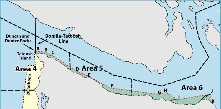
Marine Area 4, 5 and 6 Map
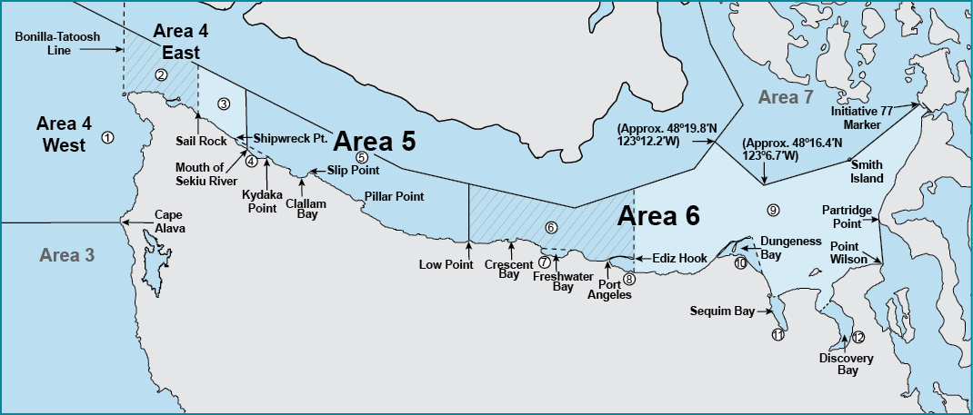
1Marine Area 4 West of the Bonilla-Tatoosh Line
2Marine Area 4 East of the Bonilla-Tatoosh Line to a north-south line through Sail Rock
3Marine Area 4 (East) from Sail Rock to mouth of Sekiu River
4Kydaka Point Area: Waters south of a line from Kydaka Point westerly approximately 4 miles to Shipwreck Point.
5Marine Area 5
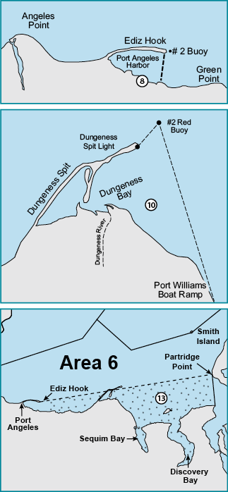
6Marine Area 6 Chinook Selective Fishery: West of a true north/south line through the #2 Buoy immediately east of Ediz Hook
7Freshwater Bay Closure - July 1-Oct. 31: Waters of Freshwater Bay south of a line from Angeles Point westerly approximately 4 miles to Observatory Point (Bachelor Rock) closed to fishing for ALL species.
8Port Angeles Harbor: Waters of Port Angeles Harbor west of a line from the tip of Ediz Hook to the ITT Rayonier Dock.
9Marine Area 6 Chinook Release Area: East of a true north/south line through the #2 Buoy immediately east of Ediz Hook
10Dungeness Bay: Waters of Dungeness Bay inside of a line from Dungeness Spit Lighthouse to the #2 Red Buoy, then to the Port Williams boat ramp.
11Sequim Bay: Waters of Sequim Bay south of a line from the southern end of Gibson Spit to the west end of Travis Spit.
12Discovery Bay: Waters of Discovery Bay south of a line from the Gardiner boat ramp to Beckett Point.
13Herring Closure Area: Waters south of a line from Ediz Hook to Partridge Point.