
Marine Area 1
(West of the Buoy 10 line at the Columbia River mouth, from the state line 46.15, N. Lat., north to Leadbetter Point)
Species |
Season |
Additional Rules |
Trout |
Year-round |
Catch-and-release |
Steelhead |
Year-round |
Daily limit 2 hatchery steelhead. |
Sturgeon |
Year-round |
Catch-and-release. |
Tuna and Mackerel |
Year-round |
No min. size. No daily limit except Northern bluefin, skipjack, and yellowfin tuna daily limit of 2 each. |
Herring, Sand Lance, and Smelt |
Year-round |
No min. size. Daily limit 10 lbs., all species combined. All smelt caught must be kept and count toward the daily limit except Closed to eulachon (Columbia River smelt). |
Anchovy and Sardine |
Year-round |
No min. size. Daily limit 25 lbs., all species combined. May be taken by a cast net. |
Pacific Halibut |
Check the WDFW website at |
|
Other Food Fish |
Year-round |
No min. size. Daily limit 2 of each species. See Definitions. |
All Other Fish |
CLOSED |
CLOSED to fishing for, retaining, or possessing. |
Salmon |
||
Entire Area |
June 24-Sept. 30, 2023 |
Chinook - min. size 22”. Coho - min. size 16”. Other salmon species - no min. size. Daily limit 2 including no more than 1 Chinook. Release wild coho. |
May-June, 2024 |
Check the WDFW website at |
|
Bottomfish |
||
Second Sat. in Mar.-Third Sat. in Oct. |
Daily limit is 9 bottomfish (see Definitions) except surfperch and flatfish. Subject to individual limits and seasons shown below. No bottomfish may be landed in Marine Area 1 if a halibut is onboard during the All-Depth Halibut Fishery, except: sablefish, Pacific cod, all flatfish species, yellowtail, widow, canary, redstriped, greenstriped, silvergray, chilipepper, bocaccio, blue/deacon rockfish, and lingcod north of the OR/WA border. On days when only the Nearshore Halibut Fishery is open for halibut, bottomfish (subject to individual limits and seasons) may be retained when halibut are onboard. |
|
Lingcod |
Second Sat. in Mar.-May 31 |
Daily limit 2. No retention or possession seaward of a line drawn from 46°38.17’ N Lat., 124°21.00’ W Lon., to 46°33.00’ N Lat., 124°21.00’ W Lon., |
June 1-June 15 |
Daily limit 2. |
|
June 16-Aug. 31 |
Daily limit 2. No retention or possession seaward of a line drawn from 46°38.17’ N Lat., 124°21.00’ W Lon., to 46°33.00’ N Lat., 124°21.00’ W Lon., |
|
Sept. 1-Sept. 30 |
Daily limit 2. |
|
Oct. 1-Third Sat. in Oct. |
Daily limit 2. No retention or possession seaward of a line drawn from 46°38.17’ N Lat., 124°21.00’ W Lon., to 46°33.00’ N Lat., 124°21.00’ W Lon., |
|
Surfperch |
Second Sat. in Mar.-Third Sat. in Oct. |
Not included in bottomfish limit. No min. size. Daily limit 12 surfperch. Except shiner perch daily limit 15: not included in bottomfish limit. When bottomfish is CLOSED: fishing from North Jetty prohibited. |
Rockfish |
Second Sat. in Mar.-April 30 |
No min. size. Daily limit 7. Release yelloweye. |
May 1-July 31 |
No min. size. Daily limit 7. Release yelloweye, copper, quillback and vermilion. |
|
Aug. 1-Third Sat. in Oct. |
No min. size. Daily limit 7. Release yelloweye. |
|
Cabezon |
Second Sat. in Mar.-Third Sat. in Oct. |
No min. size. Daily limit 1. |
Flatfish (Dabs, Sole, Flounder) |
Second Sat. in Mar.-Third Sat. in Oct. |
No min. size. In addition to the 9 bottomfish daily limit, 5 additional flatfish may be retained. |
Sixgill, Sevengill, and Thresher Sharks |
CLOSED |
CLOSED to fishing for, retaining, or possessing. Sixgill shark may not be removed from the water. |
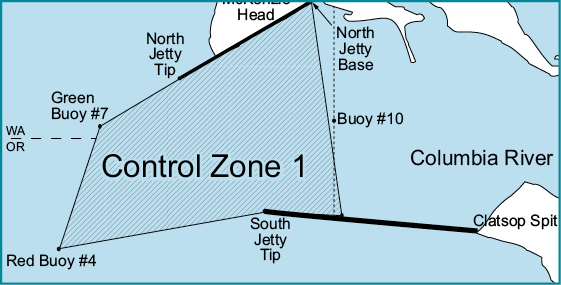
Control Zone 1: An area at the Columbia River mouth bounded on the west by a line running northeast/southwest between the red lighted Buoy #4 (46°13.58'N/124°06.83'W) and the green lighted Buoy #7 (46°15.15'N/124°06.27'W); on the east by the Buoy #10 line which bears north/south at 357° true from the south jetty at 46°14'N/124°03.12'W to its intersection with the north jetty; on the north by a line running northeast/southwest between the green lighted Buoy #7 to the tip of the north jetty (46°15.8'N/124°05.33'W), and then along the north jetty to the point of intersection with the Buoy #10 line; and on the south by a line running northeast/southwest between the red lighted Buoy #4 and the tip of the south jetty (46°14.05'N/124°04.08'W), and then along the south jetty to the point of intersection with the Buoy #10 line, is CLOSED to fishing for salmon at all times except open to fishing from the north jetty when adjacent waters north of the Control Zone are open to fishing for salmon or the Buoy 10 fishery is open.
Buoy 10 seasons: See Columbia River listing in Columbia Basin Rivers-Special Rules section.
Columbia River North Jetty: fishing for salmon and steelhead is open 7 days a week when Marine Area 1 or Buoy 10 areas are open for salmon. The daily limit and minimum size restrictions follow the most liberal regulations of either of these areas. Single-point barbless hooks required for salmon and steelhead. A saltwater or combination license is required to fish the north jetty
Washington and Oregon Reciprocity Rules: When angling or deploying shellfish gear from a vessel in the concurrent waters of the Columbia River or the Pacific Ocean within 3 miles of shore between Cape Falcon, Oregon, and Leadbetter Point, Washington, either a Washington or an Oregon fishing license is valid. NOTE: When fishing in Oregon waters, you are required to follow Oregon regulations including catch limits even if returning into a Washington port but, any fish or shellfish landed in Washington must conform to the rules in place for the point of landing.
Nearshore Halibut Fishery: Bottomfish may be retained with halibut on board in the Nearshore Halibut Fishery. The nearshore area is defined as waters shoreward of 46°38.17’N. latitude 124°15.88’W. Lon., to the WA/OR border at 46°16.00’N Lat., 124°15.88’W Lon., then connecting to the 40 fathom depth contour in Oregon. Check the WDFW website at: