Marine Area 4
(From Cape Alava north and inside Juan de Fuca Strait to the Sekiu River)
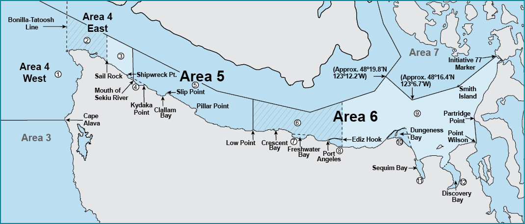
Bonilla-Tatoosh Line: A line running from the western end of Cape Flattery 48°22.86’N, 124°43.91’W, to Tatoosh Island Lighthouse 48°23.49’N, 124°44.21’W, then in a straight line to Bonilla Point on Vancouver Island 48°35.73’N, 124°43’W. See map .
Species |
Season |
Additional Rules |
Trout |
Year-round |
Catch-and-release |
Steelhead |
Year-round |
Daily limit 2 hatchery steelhead. |
Sturgeon |
Year-round |
Catch-and-release. |
Tuna and Mackerel |
Year-round |
No min. size. No daily limit except Northern bluefin, skipjack, and yellowfin tuna daily limit of 2 each. |
Herring, Sand Lance, and Smelt |
||
West of the Bonilla-Tatoosh Line |
Year-round |
No min. size. Daily limit 10 lbs., all species combined. All smelt caught must be kept and count toward the daily limit except Closed to eulachon (Columbia River smelt). For smelt: dipnets and jigs may be used 7 days a week. |
East of the Bonilla-Tatoosh Line |
Year-round |
No min. size. Daily limit 10 lbs., all species combined. All smelt caught must be kept and count toward the daily limit except Closed to eulachon (Columbia River smelt). For smelt: jig gear may be used 7 days a week. Dipnets may be used from 6:00 a.m. until 10:00 p.m. Fridays through Tuesdays. |
Anchovy and Sardine |
Year-round |
No min. size. Daily limit 25 lbs., all species combined. May be taken by a cast net. |
Pacific Halibut |
Check the WDFW website at https://wdfw.wa.gov/fishing/regulations/halibut or call (360) 902-2700 in April for information on Pacific halibut seasons and regulations. No min. size. Daily limit 1. Annual limit 4. Descending device required onboard vessels. |
|
Other Food Fish |
Year-round |
No min. size. Daily limit 2 of each species. See Definitions. |
All Other Fish |
CLOSED |
CLOSED to fishing for, retaining, or possessing. |
Salmon |
||
| West of the Bonilla-Tatoosh Line (See 1 ) |
June 17-July 31, 2023 |
Chinook - min. size 24”. Coho - min. size 16”. Other salmon species - no min. size. Daily limit 2 including no more than 1 Chinook. Release wild coho. |
Aug. 1-Sept. 30 |
Chinook - min. size 24”. Coho - min. size 16”. Other salmon species - no min. size. Daily limit 2 including no more than 1 Chinook. Release chum and wild coho. |
|
May-June, 2024 |
Check the WDFW website at wdfw.wa.gov or call (360) 902-2700 in late April for information on the 2024 salmon season. |
|
| East of the Bonilla-Tatoosh Line to north-south line through Sail Rock (See 2 ) | June 17-July 31, 2023 |
Chinook - min. size 24”. Coho - min. size 16”. Other salmon species - no min. size. Daily limit 2 including no more than 1 Chinook. Release wild coho. |
Aug. 1-Sept. 30 |
Coho - min. size 16”. Other salmon species - no min. size. Daily limit 2. Release Chinook, chum, and wild coho. |
|
May-June, 2024 |
Check the WDFW website at wdfw.wa.gov or call (360) 902-2700 in late April for information on the 2024 salmon season. |
|
| From Sail Rock to mouth of Sekiu River (See 3) (See exception for Kydaka Point Area below) | Aug. 1-Sept. 30 |
Coho - min. size 16”. Other salmon species - no min. size. Daily limit 2. Release Chinook, chum, and wild coho. |
| Kydaka Point Area (See 4 ) | Year-round |
CLOSED |
Bottomfish |
||
West of the Bonilla-Tatoosh Line |
Second Sat. in Mar.-June 30 |
Daily limit is a total of 9 bottomfish (see Definitions) except surfperch and flatfish. Subject to individual limits and seasons shown below. Descending device required onboard vessels. |
July 1-July 31 |
Daily limit is a total of 9 bottomfish (see Definitions) except surfperch and flatfish. Subject to individual limits and seasons shown below. Fishing for or possession is prohibited seaward of the 20 Fathom Depth Restriction except when halibut is open. (See 20 Fathom Depth Restriction below). Descending device required onboard vessels. |
|
Aug. 1-Third Sat. in Oct. |
Daily limit is a total of 9 bottomfish (see Definitions) except surfperch and flatfish. Subject to individual limits and seasons shown below. Descending device required onboard vessels. |
|
Note: Duncan and Duntze Rocks are seaward of the 20 fathom line. |
||
East of the Bonilla-Tatoosh Line |
Year-round |
Daily limit is a total of 9 bottomfish (see Definitions), except surfperch. Subject to individual limits, seasons, and exceptions shown below. Fishing for bottomfish prohibited in waters deeper than 120’. See Bottomfish Closure. Descending device required onboard vessels. |
Lingcod |
||
West of the Bonilla-Tatoosh Line |
Second Sat. in Mar.-Third Sat. in Oct. |
Daily limit 2. See Additional Restrictions . |
East of the Bonilla-Tatoosh Line |
Second Sat. in Mar.-Third Sat. in Oct. |
Daily limit 2. See Bottomfish Closure next page. |
Surfperch |
||
West of the Bonilla-Tatoosh Line |
Second Sat. in Mar.-Third Sat. in Oct. |
Not included in bottomfish limit. No min. size. Daily limit 12 surfperch. Except shiner perch daily limit 15: not included in bottomfish limit. |
East of the Bonilla-Tatoosh Line |
Year-round |
Not included in bottomfish limit. No min. size. Daily limit 12 surfperch. Except shiner perch daily limit 15: not included in bottomfish limit. |
Rockfish |
||
West of the Bonilla-Tatoosh Line |
Second Sat. in Mar.-Apr. 30 |
No min. size. Daily limit 7. Release yelloweye. See Additional Restrictions . |
May 1-May 31 |
No min. size Daily limit 7. Release yelloweye, copper, quillback and vermilion. |
|
June 1-June 30 |
No min. size. Daily limit 7. Release yelloweye, copper, quillback and vermilion. Fishing for or possession is prohibited seaward of the 20 Fathom Depth Restriction except when halibut is open. See 20 Fathom Depth Restricti. |
|
July 1-July 31 |
No min. size. Daily limit 7. Release yelloweye, copper, quillback and vermilion. Fishing for or possession of rockfish other than yellowtail and widow is prohibited seaward of the 20 Fathom Depth Restriction except when halibut is open. See 20 Fathom Depth Restricti. |
|
Aug. 1-Third Sat. in Oct. |
No min. size. Daily limit 7. Release yelloweye. |
|
East of the Bonilla-Tatoosh Line |
July 1-Aug. 31 |
No min. size. Daily limit 7. Only blue/deacon, yellowtail, widow, and black may be retained. Fishing for or possession of rockfish other than yellowtail and widow is prohibited seaward of a line approximating 120’. See Bottomfish Closure next page. |
Sept. 1-June 30 |
No min. size. Daily limit 7. Only blue/deacon, yellowtail, widow, and black may be retained. See Bottomfish Closure next page. |
|
Cabezon |
||
West of the Bonilla-Tatoosh Line |
Second Sat. in Mar.-Third Sat. in Oct. |
Daily limit 1. See Additional Restrictions . |
East of the Bonilla-Tatoosh Line |
Year-round |
Daily limit 1. See Bottomfish Closure next page. |
Flatfish (Dabs, Sole, Flounder) |
||
West of the Bonilla-Tatoosh Line |
Second Sat. in Mar.-Third Sat. in Oct. |
No min. size. In addition to the 9 bottomfish daily limit, 5 additional flatfish may be retained. See Additional Restrictions and Bottomfish Closure . |
East of the Bonilla-Tatoosh Line |
Year-round |
No min. size. Daily limit 9. |
Wolf-Eel |
Year-round |
CLOSED to retention. |
Sixgill, Sevengill, and Thresher Sharks |
CLOSED |
CLOSED to fishing for, retaining, or possessing. Sixgill shark may not be removed from the water. |