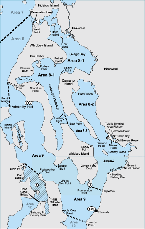
Marine Area 9
(All waters inside and south of the Partridge Point – Point Wilson line, south and west of a line from Possession Point 110° true to shipwreck, north of the Hood Canal Bridge, and north of the Apple Cove Point-Edwards Point line.)
Species |
Season |
Additional Rules |
Trout |
Year-round |
Catch-and-release. |
Steelhead |
Year-round |
Daily limit 2 hatchery steelhead. |
Sturgeon |
Year-round |
Catch-and-release. |
Mackerel |
Year-round |
No min. size. No daily limit. |
Herring, Anchovy, Sardine, Sand Lance, and Smelt |
Year-round |
No min. size. Daily limit 10 lbs., all species combined. All smelt caught must be kept and count toward the daily limit except Closed to eulachon (Columbia River smelt). For smelt: Jig gear may be used 7 days a week. Dipnets may be used from 6:00 a.m. until 10:00 p.m. Fridays through Tuesdays. |
Pacific Halibut |
Check the WDFW website at https://wdfw.wa.gov/fishing/regulations/halibut or call (360) 902-2700 in April for information on Pacific halibut seasons and regulations. No min. size. Daily limit 1. Annual limit 4. Descending device required onboard vessels. |
|
Other Food Fish |
Year-round |
No min. size. Daily limit 2 of each species. See Definitions. |
All Other Fish |
CLOSED |
CLOSED to fishing for, retaining, or possessing. |
Salmon |
||
Entire Area |
July 13-July 31 |
Open Thursdays through Saturdays only. Chinook - min. size 22”. Other salmon species - no min. size. Daily limit 2 including no more than 1 Chinook. Release chum, wild coho, and wild Chinook. |
Aug. 1-Sept. 17 |
No min. size. Daily limit 2. Release chum, wild coho, and Chinook. |
|
Sept. 18-Sept. 30 |
No min. size. Daily limit 2. Release Chinook and chum. |
|
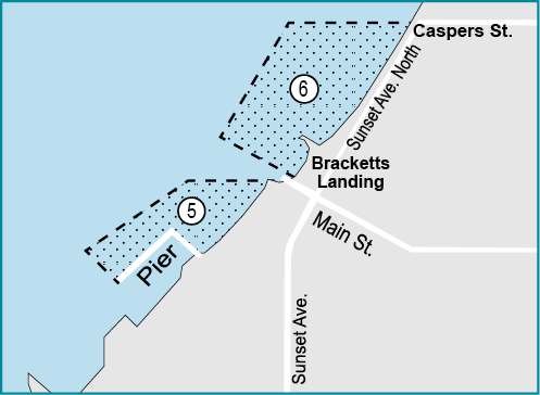
| Edmonds Public Fishing Pier (see 5 and 6 boundaries) | Oct. 1-July 31 |
Chinook - min. size 22”. Other salmon species - no min. size. Daily limit 2 including no more than 1 Chinook. |
Aug. 1-Sept. 30 |
Chinook - min. size 22”. Other salmon species - no min. size. Daily limit 2 including no more than 1 Chinook. Release chum. |
|
| Northern Hood Canal Fishery (see 7 boundaries) |
July 13-July 31 |
CLOSED. |
Aug. 1-Sept. 17 |
No min. size. Daily limit 2. Release Chinook, chum, and wild coho. |
|
Sept. 18-Sept. 30 |
No min. size. Daily limit 2. Release Chinook and chum. |
|
| Admiralty Head Marine Preserve and Keystone Conservation Area (see 8 and 9 boundaries) |
Year-round |
CLOSED. |
Bottomfish |
||
Year-round season. Daily limit is a total of 15 bottomfish (see Definitions) subject to individual limits and seasons shown below. See closures . Fishing for bottomfish prohibited in waters deeper than 120’. Descending device required onboard vessels. |
||
Lingcod |
May 1-June 15 |
Hook and line season. Min. size 26”. Max. size 36”. Daily limit 1. |
May 21-June 15 |
Spearfishing season. Max. size 36”. Daily limit 1. |
|
Surfperch |
Year-round |
No min. size. Daily limit 10. Except shiner perch daily limit 15: not included in bottomfish limit. |
Rockfish |
CLOSED |
CLOSED to fishing for, retaining, or possessing. |
Pacific Cod, Pollock, Hake, and Wolf-Eel |
Year-round |
CLOSED to retention. |
Sixgill, Sevengill, and Thresher Sharks |
CLOSED |
CLOSED to fishing for, retaining, or possessing. Sixgill shark may not be removed from the water. |
Cabezon |
May 1-Nov. 30 |
Min. size 18”. Daily limit 1. |