
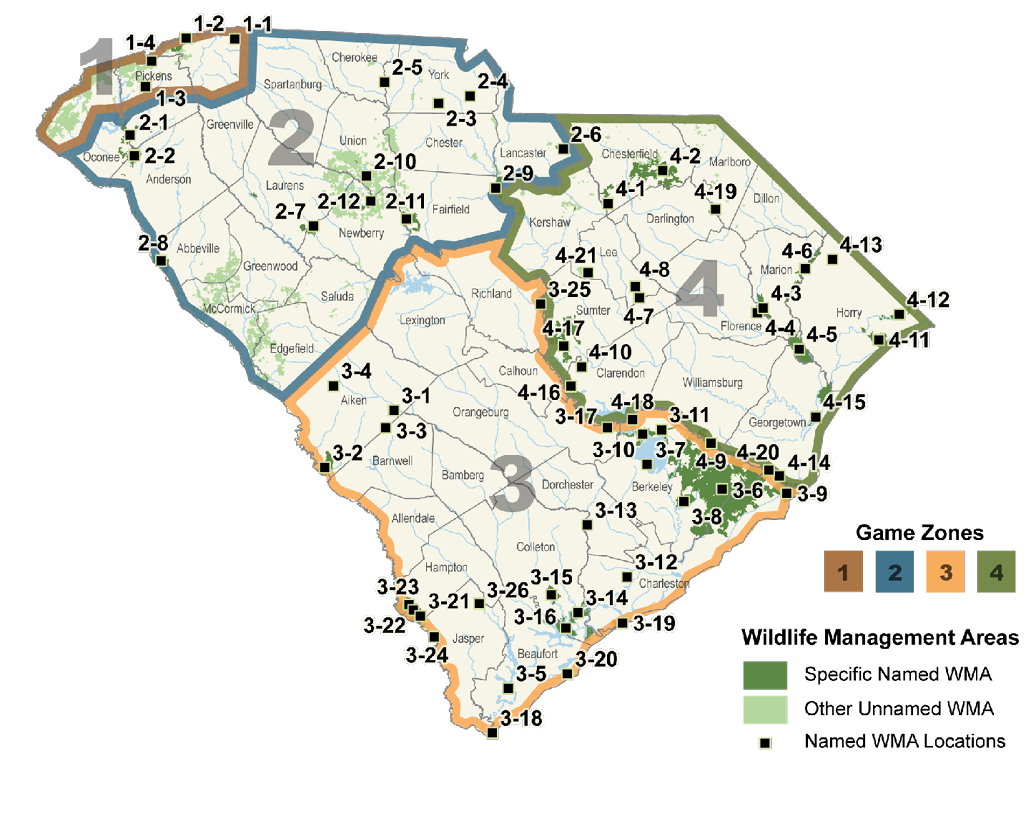
Types of WMA Properties
Two types of property are included in the Wildlife Management Area Program: “specific” named WMAs and “other” unnamed WMAs. Other WMA lands occur as scattered tracts, often leased from private landowners and the forest industry. The hunting seasons for these unnamed properties are set by Game Zone with all the “other” WMA tracts within a particular Game Zone having the same seasons. These “other” WMA lands are shown as unlabeled green tracts on the WMA maps.
“Specific” WMAs are generally larger tracts of land, many owned and managed by SCDNR and have special seasons. These “named” WMAs are shown as labeled dark green tracts on the WMA maps. The hunting seasons for named WMAs are listed within each Game Zone.
For detailed maps showing all WMAs, contact your local SCDNR Wildlife Management Office or write: WMA Maps, P.O. Box 167, Columbia, SC 29202, 803-734-3886.
New: To view and print WMA maps from the internet, go to www.dnr.sc.gov/wma/maps.html
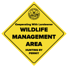
WMA properties should be marked with these yellow and black signs.
Game Zone 1 Named WMAs
1-1 - Glassy Mountain Archery/Chestnut Ridge
1-2 - Caesars Head/Jones Gap
1-3 - Mill Shoals
1-4 - South Saluda
Game Zone 2 Named WMAs
2-1 - Keowee
2-2 - Fant’s Grove
2-3 - Draper
2-4 - Rock Hill Blackjacks HP
2-5 - Worth Mountain
2-6 - Forty Acre Rock HP
2-7 - Belfast
2-8 - McCalla
2-9 - Liberty Hill
2-10 - Delta
2-11 - Broad River
2-12 - Indian Creek Quail Focal Area
Game Zone 3 Named WMAs
3-1 - Aiken Gopher Tortoise HP
3-2 - Crackerneck
3-3 - Ditch Pond HP
3-4 - Henderson HP
3-5 - Victoria Bluff HP
3-6 - Francis Marion NF
3-7 - Hatchery
3-8 - Bonneau Ferry
3-9 - Santee Coastal Reserve
3-10 - Moultrie
3-11 - Canal
3-12 - Dungannon HP
3-13 - Edisto River WMA
3-14 - Bear Island
3-15 - Donnelley
3-16 - St. Helena Sound HP
3-17 - Santee Cooper
3-18 - Turtle Island
3-19 - Botany Bay Plantation HP
3-20 - Old Island HP
3-21 - Palachucola
3-22 - Webb
3-23 - Hamilton Ridge
3-24 - Tillman Sand Ridge HP
3-25 - Wateree River HP
3-26 - Coosawhatchie
Game Zone 4 Named WMAs
4-1 - McBee
4-2 - Sand Hills State Forest
4-3 - Marsh
4-4 - Pee Dee Station Site
4-5 - Woodbury
4-6 - Little Pee Dee River HP
4-7 - Longleaf Pine HP
4-8 - Lynchburg Savanna HP
4-9 - Wee Tee
4-10 - Oak Lea
4-11 - Lewis Ocean Bay HP
4-12 - Waccamaw River HP
4-13 - Cartwheel Bay HP
4-14 - Santee Delta
4-15 - Samworth
4-16 - Hickory Top
4-17 - Manchester State Forest
4-18 - Santee Dam
4-19 - Great Pee Dee HP
4-20 - Santee Island
4-21 - Bobwhite Hills