New Jersey

Freshwater Fishing

Freshwater Fishing

Trout Fishing Regulations

Regulations in red are new this year.

General Trout Fishing Regulations for Brook, Brown & Rainbow Trout (and their hybrids and strains)
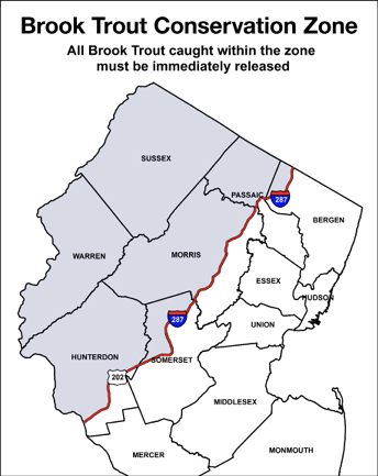
RIVERS & STREAMS (preseason closure remains in effect)

Season

Minimum Size

Daily Limit

Exceptions

January 1–March 22

9 inches

2*

  1. Catch and Release Areas, Year-Round Trout Conservation Areas, Seasonal Trout Conservation Areas, and Wild Trout Streams).
  2. Fishing is permitted during the period March 23–April 11 at 8 a.m. on rivers and streams that are not trout stocked, however all trout caught during this period must immediately be released.
  3. Delaware River.

March 23–April 11 at 8 a.m.

Fishing prohibited on trout stocked rivers and streams.

April 11 at 8 a.m.–May 31

9 inches

6*

June 1–Dec. 31

9 inches

2*

Lakes & Ponds (no longer closed during preseason)

Season

Minimum Size

Daily Limit

Exceptions

January 1–April 11 at 8 a.m.

9 inches

2

  1. Trophy and Holdover Trout Lakes.
  2. Greenwood Lake.

April 11 at 8 a.m.– May 31

6

June 1–December 31

2

Map of the New Jersey Brook Trout Conservation Zone showing counties including Sussex, Passaic, Morris, and Warren, where all brook trout must be immediately released.
Map of the New Jersey Brook Trout Conservation Zone highlighting designated counties where all brook trout caught must be immediately released. The conservation area protects native brook trout populations and supports sustainable freshwater fishing management across northern New Jersey.

Trout Stocked Waters Closed to Fishing on Spring In-season Stocking Dates

Trout Stocked Waters Closed to Fishing (5 a.m. to 5 p.m.) on Spring in-season Stocking Dates

Stocking Dates

Waterbody

County

Location

MONDAYS

April 13, 20, 27
May 4, 11, 18, 25

Manasquan River

Monmouth

Rt. 9 bridge, Howell Twp. downstream to Allenwood-Lakewood Rd. (Rt. 21), Wall Twp.

Metedeconk River, N/Br.

Ocean

Aldrich Rd. to Ridge Ave., Howell/Lakewood Twps.

Metedeconk River, S/Br.

Ocean

Bennetts Mills dam to twin wooden foot bridge, opposite Lake Park Blvd. on South Lake Dr., Lakewood Twp.

Rockaway River**

Morris

Longwood Lake dam, Jefferson Twp. to Boonton Reservoir (aka Jersey City Res.), Boonton

Toms River

Ocean

Rt. 528, Jackson Twp., to confluence with Maple Root Branch, and Rt. 70 to Rt. 571, Toms River/Manchester Twps. (Exception: the section regulated as a Year Round Trout Conservation Area; see separate regulation.)

TUESDAYS

April 14, 21, 28
May 5, 12, 19, 26

Pohatcong Creek**

Warren

Rt. 31, Washington Twp. to Delaware River

Raritan River, S/Br.**

Morris, Somerset, Hunterdon

Mill dam located 200 feet upstream from Schooleys Mountain Rd. (Rt. 517), Long Valley to junction with Raritan River N/Br. (Exception: the section regulated as Catch and Release.)

WEDNESDAYS

April 15, 22, 29
May 6, 13, 20, 27

Raritan River, N/Br.**

Somerset

Below Ravine Lake Dam within Natirar County Park, Far Hills Borough / Peapack Gladstone Borough to Raritan River S. Br.

THURSDAYS

April 16, 23, 30
May 7, 14, 21, 28

Paulinskill River, and E/Br. and W/Br.**

Sussex, Warren

Limecrest RR spur bridge on E/Br., Sparta Twp., and Warbasse Jct. Rd. (Rt. 663) on W/Br., Lafayette Twp., to confluence with the Delaware River.

Ramapo River**

Bergen

State line to Pompton Lake, Oakland (excluding Potash Lake)

FRIDAYS

April 17, 24
May 1, 8, 15, 22, 29

Big Flat/Flat Brook**

Sussex

100 ft. above Crigger Rd., Stokes State Forest, Sandyston Twp. to Delaware River
(Exception: the section regulated as Catch and Release.)

Musconetcong River**

Sussex, Morris, Warren and Hunterdon

Lake Hopatcong dam to Delaware River including all main stem impoundments except for Lake Musconetcong (Exception: the section regulated as a Year Round Trout Conservation Area; see separate regulation.)

Pequest River**

Warren and Sussex

Pequest Rd., Green Twp. to Delaware River (Exception: the section regulated as a Seasonal Trout Conservation Area; see separate regulation.)

Wanaque River**

Passaic

Greenwood Lake dam, West Milford, Twp. to Wanaque Reservoir dam, Wanaque Borough and from Wanaque Ave., Pompton Lakes Borough to Pequannock River, excluding the Wanaque and Monksville reservoirs.

Trout-Stocked Streams — Wild Brown Trout Managed

*ALL BROOK TROUT CAUGHT WITHIN BROOK TROUT CONSERVATION ZONE MUST BE IMMEDIATELY RELEASED UNHARMED.

Waterbody

Season

Species

Minimum Size

Daily Limit

Hakihohake Creek** - Little York-Mount Pleasant Rd., Little York Alexandria Twp. to Delaware R.

Lopatcong Creek** - Rt. 519, Harmony Twp., Warren to Delaware R.

Pequannock River** - Route 23, Smith Mills to railroad trestle below Appelt Park

Pophandusing Creek** - White Twp., entire length

Raritan River S/Br.** - Mill dam located 200 feet above Schooley’s Mountain Rd. (Rt 517), Long Valley (Hunterdon), downstream to Lake Solitude dam, excluding Ken Lockwood Gorge (Catch and Release Only)

Saddle River - Lake Street, Upper Saddle River Twp., to West Century Rd., Fairlawn/Paramus Boroughs

Jan. 1–March 22

Rainbow and Brook Trout*

9 inches

2 combined

Brown Trout

12 inches

March 23–April 11 at 8 a.m.

Fishing prohibited

April 11 at 8 a.m.–May 31

Rainbow and Brook Trout*

9 inches

6 combined
Only 2 of which may be Brown Trout

Brown Trout

12 inches

June 1–Dec. 31

Rainbow and Brook Trout*

9 inches

2 combined

Brown Trout

12 inches

Trout Conservation Areas (TCAs)

*ALL BROOK TROUT CAUGHT WITHIN BROOK TROUT CONSERVATION ZONE MUST BE IMMEDIATELY RELEASED UNHARMED.

Year Round TCAs

Season

Minimum Size

Daily Limit

Restrictions (in effect year round)

Jan. 1–March 22

15 inches

1

  1. Only artificial lures and flies may be used.
  2. Possession or use of bait (live or preserved) or any substance (natural or synthetic) that contains a concentration of bait scent is prohibited.
  3. Fishing is allowed during the spring in-season closures, which apply to the river. All trout caught during these periods must be released immediately.

March 23–April 11 at 8 a.m.

Catch and release only

April 11 at 8 a.m.–Dec. 31

15 inches

1 (see #3 at right)

Year Round TCA Waterbody (County)

Driving Directions *

Musconetcong River**—Point Mountain Stretch (Hunterdon/Warren) Penwell Rd. bridge downstream to Point Mountain Rd. bridge (approx. 1.2 miles)

Rt. 31 to Rt. 57 E. Upper boundary: turn right on Penwell Rd. Lower boundary: turn right on Point Mountain Rd. Parking areas located near each bridge.

Toms River (Ocean) End of Riverwood Park (Tom’s River Twp.) downstream to Rt. 571 bridge (approx. 1 mile)

Rt. 195 (Exit 21) to Rts. 527/528 S. (Cedar Swamp Rd./ Veterans Hwy.) to Rt. 527 S. (Whitesville Rd.) to Riverwood Dr. to entrance of Riverview Park.

Seasonal TCAs

Season

Minimum Size

Daily Limit

Restrictions

Jan. 1–March 22

15 inches

1

  1. Only artificial lures may be used.
  2. Possession or use of bait (live or preserved) or any substance (natural or synthetic) that contains a concentration of bait scent is prohibited.
  3. Pequest River — fishing is not permitted during the first six in-season stocking closure dates. (See Trout Stocked Waters Closed to Fishing on Spring Stocking Dates). Fishing is permitted during the last in-season stocking closure date (May 25), but all trout caught between 5 a.m. and 5 p.m. must be immediately released.

March 23–April 10

Catch and release only

April 11 (12:01 a.m. to 8 a.m.)

Fishing prohibited

April 11 at 8 a.m.–May 24
Gear restrictions do not apply

9 inches

6

May 25–Dec. 31

15 inches

1

Seasonal TCA Waterbody (County)

Driving Directions *

Pequannock River** (Morris/Passaic) Railroad trestle below Appelt Park, Bloomingdale, downstream to Hamburg Turnpike bridge, Pompton Lakes (approx. 1.3 miles)

I-287 (Exit 53). Proceed west on (Paterson) Hamburg Turnpike 0.34 miles. Right on Brant Ln. Railroad trestle below Appelt Park is the upstream boundary.

Pequest River** (Warren) Conrail Railroad bridge, located upstream of the Pequest Trout Hatchery Access Road, downstream to Rt. 625 (Pequest Furnace Rd.) bridge (approx. 1.4 miles)

Rt. 31 to Rt. 46 E, approx. 4 mi. to Pequest Trout Hatchery; paved parking lot.

Catch and Release Areas

Season

Minimum Size

Daily Limit

Restrictions

Jan. 1–Dec. 31
Fishing allowed year-round

Catch and release all trout

  1. All trout must be released immediately and unharmed. A person may not have any trout in their possession.
  2. Only artificial lures and flies may be used.
  3. Barbless hooks only, with no more than a total of three hook points.
  4. Possession or use of bait (live or preserved) or any substance (natural or synthetic) that contains a concentration of bait scent is prohibited.
  5. Fishing is allowed during the spring in-season stocking closures, which apply to the rivers.

Catch and Release Waterbody (County)

Driving Directions

Big Flat / Flat Brook (Sussex) Rt. 206 bridge downstream to the Roy Bridge on Mountain Rd., a distance of 4.2 miles, including the portion known as the Blewett Tract.

Upper boundary: Rt. 206 bridge, approx. 1.6 miles north of entrance to Stokes State Forest (Coursen Road). Lower boundary: Rt. 206 north, app. 1 mile past Stokes State Forest entrance, turn left on Rt. 560. At Layton bear left on Bevans Rd. (Rt. 640) towards Walpack. Continue south 3.4 miles (NPS Rd 615), left onto Fish and Wildlife Rd. to Roy Bridge.

Raritan S/Br.—Ken Lockwood Gorge (Hunterdon)
Section of S. Br. within the Ken Lockwood Gorge Wildlife Management Area (approx. 2.2 miles).

Ken Lockwood Gorge — Road in gorge is closed to through traffic. Route 31 to Rt. 513. Upper boundary: Turn right at Hoffman’s Crossing Rd., take first right after bridge. Lower boundary: Turn right onto Silverthorne-Cokesbury Rd., turn left after crossing river. Park only in designated areas.

Wild Trout Streams

Native Brook Trout Streams (Brook Trout Dominant)

Species

Minimum Size

Season

Daily Limit

Gear

Brook Trout

Catch & Release

April 11 at 8 a.m. to Sept. 15
Catch and Release at all other times, year-round

2 Brown or Rainbow Trout combined

  • Fishing allowed year-round
  • Artificials only, with no more than 3 hook points in total, all barbless
  • Possession or use of bait, or synthetic bait with bait scent prohibited

Rainbow Trout

No min. size

Brown Trout

No min. size

Wild Trout Streams (Multiple wild trout species present)

Species

Minimum Size

Season

Daily Limit

Gear

Brook Trout

Catch & Release in Zone

April 11 at 8 a.m. to Sept. 15
Catch and Release at all other times, year-round

2 Brown or Rainbow Trout combined

  • Fishing allowed year-round
  • Artificials only, with no more than 3 hook points in total, all barbless
  • Possession or use of bait, or synthetic bait with bait scent prohibited

Rainbow Trout

9”

Brown Trout

9”

Wild Brown Trout Enhancement Streams (Brown Trout dominant, other wild trout species may be present)

Species

Minimum Size

Season

Daily Limit

Gear

Brook Trout

Catch & Release in Zone*

April 11 at 8 a.m. to Sept. 15
Catch and Release at all other times, year-round

2 Brown or Rainbow Trout combined

  • Fishing allowed year-round
  • Artificials only, with no more than 3 hook points in total, all barbless
  • Possession or use of bait, or synthetic bait with bait scent prohibited

Rainbow Trout

9”

Brown Trout

12”

Trout Lakes

Trophy Trout Lakes

Waterbody (County)

Species

Season

Minimum Size

Daily Limit

Merrill Creek Reservoir*(Warren)

Brown & Rainbow Trout (and their hybrids) and Landlocked Atlantic Salmon

Open year-round

15 inches

2 combined

Lake Trout

Open year-round

15 to less than 24 inches AND greater than or equal to 24 inches

2
AND
2

Round Valley Reservoir(Hunterdon)

Brown & Rainbow Trout (and their hybrids)

Open year-round

15 inches

2 combined

Lake Trout

Open year-round

15 to less than 24 inches AND greater than or equal to 24 inches

8
AND
1

Holdover Trout Lakes

Waterbody (County)

Species

Season

Minimum Size

Daily Limit

Clinton Reservoir (Passaic)

Lake Aeroflex* (Sussex)

Lake Wawayanda* (Sussex)

Sheppard Lake (Passaic)

Tilcon Lake* (Morris)

White Lake (Warren)

Brown & Rainbow Trout and their hybrids

Jan. 1–April 11 at 8 a.m.

9 inches

2

April 11 at 8 a.m.–May 31

9 inches

4

June 1–Dec. 31

9 inches

2

Landlocked Atlantic Salmon

Open year-round

12 inches

2

NJ's Freshwater Fishing Explorer App

NJDEP Fish & Wildlife's new Freshwater Fishing Explorer App combines the Great Fishing Close to Home App, the Trout Waters Map and the brand new Fishing Regulations App in one place!

QR code linking to the New Jersey Freshwater Fishing Explorer tool for finding fishing locations, species information, and access points statewide.
Scan this QR code to access the New Jersey Freshwater Fishing Explorer, an interactive tool to find fishing locations, view species information, and discover public access points across the state.

The Trout Stocked Waters tab provides the stocking dates and number of trout stocked for all trout stocked waters in our spring trout stocking program. Clicking on a water feature within the map will pull up the stocking schedule, the number of fish to be stocked and closures.

QR code linking to the New Jersey Trout Stocked Waters interactive map app for viewing trout stocking locations and freshwater fishing areas.
Scan this QR code to access the New Jersey Trout Stocked Waters interactive map app, where anglers can view trout stocking locations, explore freshwater fishing areas, and plan their next fishing trip.

The Great Fishing Close to Home tab allows users to explore the great diversity of fishing opportunities New Jersey has to offer.

QR code linking to the New Jersey “Great Fishing Close to Home” map app for finding nearby freshwater fishing locations and access points.
Scan this QR code to access the New Jersey “Great Fishing Close to Home” interactive map app and discover nearby freshwater fishing locations, public access sites, and local angling opportunities across the state.

Fishing Regulations App. Click on each waterbody to determine the exact fishing regulations for that water!

QR code linking to the New Jersey Freshwater Fishing Regulations map app for viewing current fishing rules, seasons, and location-specific regulations.
Scan this QR code to access the New Jersey Freshwater Fishing Regulations map app, where anglers can review current fishing seasons, size and bag limits, and location-specific freshwater fishing rules across the state.

Find freshwater fishing regulations, stocking schedules, and species information on the NJDEP Freshwater Fishing page.