Areas Closed To Hunting & Trapping
The Following Areas are Closed to All Hunting and Trapping
(Refer to NAC 504.340)
Note: This is not an all-encompassing list of areas closed to hunting by federal, state and local regulations. Please contact the appropriate tribe or land management agency for information on hunting closures in specific areas.
Those portions of the Lake Mead National Recreation Area which are within:
- A 1-mile radius of Overton Landing, Willow Beach, Rogers Spring, the area for cabins at Stewart’s Point, Echo Bay, Eldorado Canyon, Cottonwood Cove and the petroglyphs of Grapevine Canyon.
- The Lower or Boulder Basin, including all of the area from Hoover Dam to a line running north and south near the peninsula between Hamblin Bay and Rotary Cove. The townships or portions of them located within the Lake Mead National Recreation Area and included within this closed area are: T. 20 S., R. 63 E., R. 64 E., R. 65 E.; Sections 6, 7 and 18 of T. 21 S., R. 66 E.; T. 21 S., R. 63 E., R. 63 1/2 E., R. 64 E., R. 65 E. and T. 22 S., R. 64 E. and R. 65 E., M.D.B. & M.
- A 1/2-mile strip parallel to the west shoreline of Lake Mohave from Hoover Dam south to a point 2 miles south of the campground at Willow Beach.
- The area of land extending 1/2 mile west of the water elevation of Lake Mohave and the Colorado River between the southern boundary of the Lake Mead National Recreation Area and the crossing of those cables of the power line located approximately 5 1/4 miles north of Davis Dam and all waters between that cable and the southern boundary.
All portions of the Stillwater National Wildlife Refuge in Churchill County south of Division Road,
except that trapping is allowed to the extent authorized pursuant to 50 C.F.R. §§ 31.14 and 31.16.
All portions of the Ruby Lake National Wildlife Refuge, except that:
- Hunting is allowed pursuant to 50 C.F.R. § 32.47 on designated areas of the refuge in Elko and White Pine Counties and to the extent authorized by the Board of Wildlife Commissioners in regulations governing seasons, hours and bag limits adopted pursuant to NRS 501.118; and
- Trapping is allowed to the extent authorized pursuant to 50 C.F.R. §§ 31.14 and 31.16 and by the Board of Wildlife Commissioners in regulations governing seasons, hours and bag limits adopted pursuant to NRS 501.118.
All portions of the Death Valley National Park.
All portions of the Sheldon National Wildlife Refuge,
except that hunting is authorized on designated areas of the refuge pursuant to 50 C.F.R. § 32.47, to the extent permitted by the Board of Wildlife Commissioners in regulations governing seasons, hours and bag limits adopted pursuant to NRS 501.118.
All portions of the Great Basin National Park.
All portions of Clark, Lincoln and Nye Counties within the boundaries of the Nellis Air Force Range, the Nevada Test and Training Range (NTTR) and the Desert National Wildlife Refuge,
except that the hunting of bighorn sheep is authorized in certain described portions of the Desert National Wildlife Refuge pursuant to 50 C.F.R. § 32.47 and the Nellis Air Force Range, to the extent authorized by the Board of Wildlife Commissioners in regulations governing seasons, hours and bag limits adopted pursuant to NRS 501.118.
All portions of Clark, Lincoln and Nye Counties within the boundaries of the Nellis Air Force Range, the Nevada Test and Training Range (NTTR) and the Desert National Wildlife Refuge,
except that certain described portions of the Desert National Wildlife Refuge, not within Nellis Air Force Range, will be opened for the hunting of deer pursuant to 50 C.F.R. § 32.47, to the extent authorized by the Board of Wildlife Commissioners in regulations governing seasons, hours and bag limits adopted pursuant to NRS 501.118.
All portions of the Pahranagat National Wildlife Refuge in Lincoln County,
except that hunting is permitted on designated areas of the refuge pursuant to 50 C.F.R. § 32.47, to the extent authorized by the Board of Wildlife Commissioners in regulations governing seasons, hours and bag limits adopted pursuant to NRS 501.118.
All portions of the Ash Meadows National Wildlife Refuge,
except that hunting is permitted on designated areas of the refuge pursuant to 50 C.F.R. § 32.47, to the extent authorized by the Board of Wildlife Commissioners in regulations governing seasons, hours and bag limits adopted pursuant to NRS 501.118.
Trapping is prohibited within 1,000 feet of each side of the following designated hiking trails
established within that portion of the Humboldt-Toiyabe National Forest that is located north of the Washoe County-Carson City line, west of U.S. Highway No. 395 and south of U.S. Interstate Highway No. 80:
- Hunter Creek Trail, United States Forest Service Trail No. 21053;
- Jones Creek-Whites Creek Trail, United States Forest Service Trail No. 21056;
- Ophir Creek Trail, United States Forest Service Trail No. 21059;
- Tahoe Rim Trail, United States Forest Service Trail No. 21055; and
- Thomas Creek Trail, United States Forest Service Trail No. 21057.
Trapping is prohibited, other than with a box or cage trap, within 1,000 feet of
each side of the following designated hiking trails, campgrounds, picnic areas and recreation areas established within that portion of the Humboldt-Toiyabe National Forest that is located west of U.S. Highway No. 95 and north and east of State Route No. 160 in the Spring Mountains National Recreation Area:
- Bristlecone Trail, United States Forest Service Trail No. 148;
- Cathedral Rock Trail, United States Forest Service Trail No. 155;
- Echo/Little Falls Trail, United States Forest Service Trail No. 141;
- Fletcher Canyon Trail, United States Forest Service Trail No. 165;
- Griffith Peak Trail, United States Forest Service Trail No. 140;
- Mary Jane Falls Trail, United States Forest Service Trail No. 159;
- Mummy Springs Trail, United States Forest Service Trail No. 161;
- North Loop Trail, United States Forest Service Trail No. 146;
- Robber’s Roost Trail, United States Forest Service Trail No. 162;
- Sawmill Loop Trail, United States Forest Service Trail No. 973;
- South Loop Trail, United States Forest Service Trail No. 145;
- Trail Canyon Trail, United States Forest Service Trail No. 147;
- Dolomite Campground;
- Fletcher View Campground;
- Hilltop Campground;
- Kyle Canyon Campground and Picnic Area;
- Mahogany Grove Group Campground;
- McWilliams Campground;
- Cathedral Rock Picnic Area;
- Cathedral Rock Group Picnic Area;
- Deer Creek Picnic Area;
- Foxtail Group Picnic Area;
- Old Mill Picnic Area;
- Sawmill Picnic Area; and
- Blue Tree Dispersed Recreation Area, including United States Forest Service Trail Nos. 849, 850, 851 and 852.
Trapping is prohibited, other than with a box or cage trap, within one-half mile of
any residence in the Spring Mountains National Recreation Area, T. 19 S., R. 59 E., Sections 3, 7, 8, 9, 10 and 16.
Trapping is prohibited, other than with a box or cage trap, within 200 feet of
each side of the following designated multi-use routes:
- Cardamine Road, United States Forest Service Road No. 001;
- Champion Road, United States Forest Service Road No. 203;
- Mack’s Canyon Road, United States Forest Service Road Nos. 073, 073A and 073B;
- Power Line Road, United States Forest Service Road Nos. 577, 577A, 577B, 872 and 873; and
- Telephone Canyon Road, United States Forest Service Road Nos. 530 and 530A.
Trapping Visitation Requirements
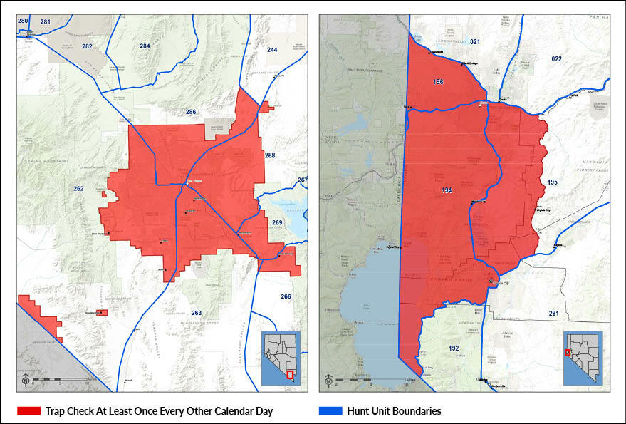
1. A person who is required pursuant to NRS 503.570 to visit or cause to be visited a trap, snare or similar device shall ensure that the trap, snare or similar device is visited:
- At least once every other calendar day in the following units for wildlife, as designated in NAC 504.210, or portions of those units specified in this paragraph other than any private property located within those units or if a box or cage trap is used:
- All of Unit 194;
- The following portions of Unit 195:
- West of Lagomarsino Canyon-Lousetown Road from its intersection with Interstate Highway No. 80 to its intersection with State Route No. 341; and
- West of State Route No. 341 from its intersection with Lousetown Road to its intersection with U.S. Highway No. 50;
- All of Unit 196; and
- The portion within the Clark County Illegal Firearms Discharge Area created by the Clark County Geographic Information Systems Management Office on September 11, 2013;
- At least once each 96 hours in all other units for wildlife, as designated in NAC 504.210, or portions of those units not specified in paragraph (a), including any private property located within those units;
- At least once each 96 hours if a box or cage trap is used;
- By a person who is a holder of a trapping license issued by the Department; and
- In a manner which ensures that any mammal caught in the trap, snare or similar device is removed from the trap, snare or similar device.
2. A person who is required pursuant to NRS 503.570 to visit or cause to be visited a trap, snare or similar device and who uses a manned or unmanned aircraft to visit a trap, snare or similar device shall be deemed to have not visited the trap, snare or similar device for the purposes of this section and NRS 503.570.
(Refer to NAC 503.152)
(Refer to NAC 503.148 in General Hunting Laws & Regulations)
Trapping Visitation Requirements