Fishing Regulations
New for 2023
- Three new sections of streams were placed under Catch and Release Regulations. Thethree streams are the upper Guyandotte and all tributaries in Wyoming County, Barkers Creek and tributaries in Wyoming County, and Elkhorn Creek and tributaries in McDowell County.
- The Delayed Harvest Regulation was modified to be Catch and Release from Nov. 1 toMay 15 and General Regulations from May 16 to Oct. 31.
- Delayed Harvest sections were established on Paint Creek in Fayette County,Williams River in Pocahontas County and Shavers Fork in Randolph County.
- Blue catfish on the Ohio and Kanawha rivers are now under a special regulation of 25-inch minimum size limit, 4-fish daily creel, and only one can be over 35 inches in length.
Special Areas Regulations
Black Bass
CATCH-AND-RELEASE
For waters listed below
- All black bass (smallmouth, spotted and largemouth) caught must be returned to the water at once.
- No black bass shall be in the angler’s possession (creel limit 0) while fishing in designated catch-and-release lakes and streams.
Lakes
Dunkard Fork, Edwards Run Pond, Elk Fork, Kimsey Run, Millers Fork Pond, North Bend, O’Brien, Rockhouse, Tuckahoe, Upper Mud and Woodrum.
Streams
New River – Fayette, Raleigh and Summers counties
12-mile section from the I-64 bridge at Sandstone downstream to NPS Grandview Sandbar access site near Quinnimont. Access by state Route 41 at Quinnimont and state Route 20 at Sandstone.
South Branch of Potomac River – Hardy and Hampshire counties Area 1 8-mile section in Hardy County from 3 miles east of Petersburg
at the routes 28, 55 and 220 bridge (Petersburg Gap bridge) downstream to the county Route 13 bridge (Fisher bridge).
Area 2 9.5-mile section in Hampshire County from the routes 28 and 50 bridge (Romney bridge) downstream to the state Route 28 bridge (Blue Beach bridge).
SLOT LIMIT
New River
- All black bass (smallmouth, spotted, and largemouth) from 14 to 22 inches long must be returned to the water at once.
- Daily creel limit of six black bass with only one being over 22 inches.
- This regulation is in effect from the confluence of the New and Gauley rivers upstream to the West Virginia/Virginia state line, excluding Bluestone Lake (from the dam upstream to the mouth of Indian Creek) and the 12-mile catch and release section (from the Grandview sandbar boat ramp upstream to the I-64 bridge at Sandstone).
South Mill Creek Lake and Parker Hollow Lake
- All black bass (smallmouth, spotted and largemouth) from 12 to 16 inches long must be returned to the water at once.
- All black bass harvested must be in accordance with the daily creel limit regulation.
Greenbrier River – Greenbrier County
6-mile section beginning at the U.S. Route 60 bridge near Caldwell extending downstream to the U.S. Route 219 bridge at Ronceverte.
- All black bass (smallmouth, spotted and largemouth) from 12 to 20 inches long must be returned to the water at once.
- Daily creel limit of one black bass over 20 inches caught within the slot limit area. Black bass under 12 inches may be harvested. All black bass harvested must be in accordance with the daily creel limit regulation.
MINIMUM SIZE LIMIT
Stonewall Jackson Lake
- Daily creel limit of one black bass (smallmouth, spotted and largemouth) 18 inches or longer.
- Black bass under 18 inches may be harvested.
- All black bass harvested must be in accordance with the daily creel limit regulation.
- Registered bass tournament anglers who are participating in DNR-permitted tournaments only are excluded from this regulation.
For waters listed below
All black bass (smallmouth, spotted and largemouth) under 12 inches long must be returned to the water at once.
Lakes
Barboursville, Beech Fork, Chief Logan and Conaway Run.
Streams
Wheeling Creek – Marshall and Ohio counties
Entire length.
Ohio River
Entire length of Ohio River from the mouth of Mill Creek, Hancock County, downstream to the mouth of the Big Sandy River, Wayne County. This regulation applies to all waters included in the Ohio River Reciprocal Agreement with the State of Ohio.
Fish Handling and Release
When practicing catch-and-release fishing, survival of the released fish can be greatly enhanced by following these simple guidelines.
- Time is important — play and release the fish as quickly as possible to reduce unnecessary stress.
- Keep the fish in the water as much as possible and use a pair of forceps or needle-nosed pliers to remove the hook.
- Handle the fish with bare, wet hands. Do not squeeze the fish, put your fingers in the eyes or gills, or cause scale loss.
- When releasing the fish, hold it gently in the water until the fish is ready to swim off on its own.
- You may take time to snap a quick photo of your catch before releasing it.
- To release a deeply hooked or gill-hooked fish, cut the line 5 to 6 inches above the lure.
Children and Handicap Fishing Areas
For waters listed below
- Areas are managed under special regulations March-May.
- During this period fishing is restricted to children 14 years of age or under and to people with disabilities holding a Class Q permit.
- Fishing permitted during daylight hours only.
- Creel limit is four trout.
- Another person may assist with baiting hooks and removing fish.
Lakes
Baker Lake – Ohio County
3-acre lake in Bear Rock Lakes WMA. Access by county Route 41/6.
Bishop Knob Pond – Webster County
2-acre lake between Cranberry and Williams rivers. Access by Forest Road 101.
Coonskin Park Pond – Kanawha County
2.7-acre pond in Coonskin Park. Access is off I-77, Exit 1, U.S. Route 119 north to Henry Shores Drive.
Handley Pond – Pocahontas County
5-acre pond on the Handley WMA. Access by county Routes 17 and 17/1 that intersect U.S. Route 219 at Edray north of Marlinton.
Logan County Airport Pond
1-acre pond. Access by county Route 119/8 off state Route 17.
Millers Fork Pond – Wayne County
5-acre pond on the Beech Fork Lake WMA. Access by county Route 22 off county Route 17.
Raleigh County Airport Pond
1-acre pond at the entrance to the Raleigh County Airport. Access by county Route 9/9 off I-64 at Airport Exit 125-B.
Underwood Lake – Cabell County
1-acre pond on Huntington YMCA property. Access by state Route 2.
Westover Park Pond – Monongalia County
1-acre pond located at the Westover Park just off U.S. Route 19 approximately .5 mile east of I-79 Westover exit.
Streams
Davis Creek - Kanawha County
From Route 23 bridge near the entrance of Kanawha State Forest upstream including all tributaries (17.2 miles).
Laurel Fork – Wyoming County
300-yard section of Laurel Fork in Gilliand Park in Oceana. Access is by Route 10.
Mash Fork of Camp Creek – Mercer County
100-yard section of Mash Fork in Camp Creek State Park/ State Forest at Mash Fork Waterfalls. Access by county Route 19/5 from I-77, exit 20.
All Species
CATCH-AND-RELEASE
Dixon Lake (Pedlar Wildlife Management Area)
- All species of fish must be returned to the water at once.
- No fish shall be in the angler’s possession (creel limit 0) while fishing in designated catch-and-release lakes and streams.
- Use of live minnows is prohibited.
- Use of barbed hooks is prohibited.
Regulations Public Meetings
WVDNR staff will be available to discuss and take public comments for proposed 2023 regulations.
March 13, 2023
Beckley, Elkins, Grafton, Harrisville, Martinsburg and Milton
March 14, 2023
Flatwoods, Lewisburg, Logan, Moorefield, Parkersburg and Triadelphia
Catfish
For waters listed below
- Daily creel limit of four flathead catfish, of which only one may be 35 inches or longer.
- Possession limit of eight.
- Daily creel limit of four blue catfish with a 25-inch minimum size on the Kanawha and Ohio rivers. Only one may exceed 35 inches. The possession limit is eight, only two of which may exceed 35 inches.
Streams
Kanawha River
Mouth of Kanawha River extending upstream to the confluence of the New and Gauley rivers.
Monongahela River
Entire length of Monongahela River (flathead catfish only) from the Pennsylvania state line to the confluence of the Tygart Valley and West Fork rivers.
Ohio River
Entire length of Ohio River from the mouth of Mill Creek, Hancock County, downstream to the mouth of the Big Sandy River, Wayne County. This regulation applies to all waters included in the Ohio River Reciprocal Agreement with the state of Ohio.
HAND-FISHING FOR CATFISH ONLY
- Season for hand-fishing runs from June 15 through Aug. 31 with fishing permitted from sunrise until sunset.
- Hand-fishing is prohibited in all state-managed impoundments except Stonecoal, Hawks Nest, Mt. Storm, Cheat, and U.S. Army Corps of Engineers lakes.
- Daily creel limit for all catfish species taken by hand-fishing is four total with only one fish allowed to be over 35 inches and only two of which may be blue catfish (minimum length 24”). In waters with special regulations, the more restrictive regulations apply. The daily creel limit for hand-fishing counts as part of any daily limit for hook and line fishing.
- Use or possession of hooks, gaffs, spears or anything other than hands while hand-fishing is prohibited, as is the use of bait or fish attractors. Only naturally-occurring cavities and naturally-occurring habitat may be hand-fished. The placement or use of artificial cavities and nesting boxes for hand-fishing is prohibited. The use of SCUBA gear or any other artificial breathing apparatus to hand fish is prohibited.
Muskellunge
CATCH-AND-RELEASE
For waters listed below
- All muskellunge caught must be returned to the water at once.
- No muskellunge shall be in the angler’s possession while on stream sections designated as catch-and-release streams.
Streams
Buckhannon River – Upshur County
6.5-mile section beginning at the City of Buckhannon’s water supply dam and continuing upstream to the first riffle. Included in this area is the section of French Creek from its mouth to the first riffle. The entire stream section is commonly referred to as Buckhannon Pool.
Middle Island Creek – Tyler County
6-mile section beginning at the state Route 18 bridge near Centerville and continuing downstream to the low water bridge near the Jug WMA. Included in this area are sections of Indian Creek and McElroy Creek from their mouths to their first riffles.
MINIMUM SIZE LIMIT
North Bend Lake
- All muskellunge under 40 inches long must be returned to the water at once.
- Daily creel limit of one muskellunge.
Stonewall Jackson Lake (Including entire drainage upstream of the lake)
- All muskellunge under 52 inches long must be returned to the water at once.
- Daily creel limit of one muskellunge.
North Fork Hughes River – Ritchie County
1.3-mile section extending from North Bend Lake Dam downstream to the CR 809 bridge near the North Bend State Park campground.
- All muskellunge under 40 inches long must be returned to the water at once.
- Daily creel limit of one muskellunge.
Sunfish
SIZE LIMIT AND CREEL LIMIT
Mason Lake (Monongalia County) and Teter Creek Lake (Barbour County)
10-fish daily creel limit, of which only five fish may be 8 inches or longer for bluegill and all other sunfish species (e.g., pumpkinseed, green sunfish, hybrid sunfish, etc.) in aggregate.
Trout
CATCH-AND-RELEASE
For catch-and-release waters listed on page 6
- Fishing permitted during daylight hours only, except that on the three North Branch of the Potomac River Catch-and-Release Trout Fishing Areas fishing is permitted between the hours of 5:30 a.m. and 10 p.m. only.
- Only artificial flies and lures made of metal, wood, feathers, hair, or synthetic material may be used or possessed on catch- and-release trout streams. No lure or fly with any scent, oil, or edible enticement added onto, or impregnated into (regardless if the scent is added in the manufacturing process or applied afterward), may be used or possessed on any catch-and-release trout stream.
- Multiple hook lures must have barbless hooks (except on the North Branch of the Potomac River Catch & Release areas).
- Single hook lures may have barbed hooks.
- All trout caught must be returned to the water at once.
- No trout shall be in the angler’s possession while on stream sections designated as catch-and-release streams.
- Powerbait, Gulp and other manufactured scented baits are considered illegal under this section and may not be used or possessed on catch-and-release streams.
Streams
Back Fork of Elk River – Webster County
4-mile section beginning 2 miles upstream from Webster Springs and extending upstream. Access by county Routes 24 and 24/3.
Barkers Creek of Guyandotte River – Wyoming County
From the mouth of Barkers Creek upstream to include the entire drainage area for a total of 88 stream miles.
Blackwater River – Tucker County
3.5-mile section from the county Route 29/1 bridge in Blackwater Falls State Park downstream to the mouth of the North Fork.
Bluestone River – Summers County
1-mile section from the mouth of Mountain Creek downstream to a stream gauge station within Pipestem State Park.
Cranberry River – Webster, Pocahontas and Nicholas counties
4.3-mile section from the junction of the North and South forks downstream to the low water bridge at Dogway Fork. Access by foot on National Forest Route 76 from the Cranberry Glades parking area.
Elkhorn Creek – McDowell County
From the mouth of Elkhorn Creek upstream to include the entire drainage area for a total of 171 stream miles.
Elk River – Randolph County
2-mile section from the Elk Springs Campground downstream to Rose Run bridge. Access by county Route 49 off state Route 15 about 4 miles west of Valley Head.
Glade Creek of New River – Raleigh County
3-mile section from the mouth upstream to the National Park Service foot bridge. Access by Glade Creek Road off state Route 41.
Guyandotte River – Wyoming and Raleigh counties
Entire drainage upstream of railroad bridge in Mullens, including all tributaries and totaling 101 miles.
Middle Fork of Williams River and tributaries – Webster/Pocahontas counties
Mill Creek – Randolph County
Entire length of Mill Creek and its tributaries within Kumbrabow State Forest.
North Branch of Potomac River – Grant and Mineral counties See the current Maryland Fishing Regulations for special regulations on the North Branch of the Potomac and Potomac rivers.
North Fork of Cherry River – Nicholas County
1.8-mile section extending upstream from Richwood’s water supply dam to first state Route 39 bridge. Access by state Route 39.
North Fork of Cranberry River – Pocahontas County
0.25-mile section from the mouth upstream to the limestone treatment dam. Access by foot on National Forest Route 76.
North Fork of the South Branch – Pendleton County
0.75-mile section at the mouth of Seneca Creek near Seneca Rocks Visitors Center. Access by county Route 28/3 at junction of state Route 28 and U.S. Route 33 at Seneca Rocks.
Otter Creek and tributaries – Randolph/Tucker counties
Red Creek and tributaries – Tucker County
Upstream of county Route 45 bridge.
Seneca Creek – Pendleton County
0.20-mile section from the mouth extending upstream to the Route 28 bridge.
Slatyfork section of Elk River – Pocahontas County
4.6-mile section from the junction of Big Spring and Old Field forks downstream to the mouth of Dry Branch, including Props Run and Big Run. Access by foot from county Routes 219/2 on the north and 219/12 on the south.
South Branch of the Potomac River – Pendleton County
1-mile section beginning 2 miles below U.S. Route 220 at Eagle Rock and extending downstream. Access by county Route 2.
Tea Creek and tributaries – Pocahontas County
Upstream of Tea Creek Campground
DELAYED HARVEST STREAMS
For waters listed below
- Catch-and-release regulations apply: November 1 – May 15.
- General regulations apply: May 16 – October 31.
Streams
Clear Fork of the Guyandotte River – Wyoming County
1-mile section from the R.D. Bailey WMA manager’s residence downstream to the state Route 6 bridge.
Middle Wheeling Creek – Ohio County
1.2-mile section from just above the upper limits of Middle Wheeling Creek Lake upstream to mouth of Gillespie Run. Access by county Route 39/6.
Paint Creek - Fayette and Kanawha counties
From Ash Branch upstream 12.5 miles to the mouth of Milburn Creek.
Shavers Fork River - Randolph County
The 5.5-mile section extending from the mouth of Whitmeadow Run downstream to the mouth of McGee Run.
Williams River - Pocahontas County
From a signed location approximately 2 miles downstream of Tea Creek extending 2 miles downstream. Access by National Forest Route 86.
FLY FISHING ONLY
For waters listed below
- Fishing permitted during daylight hours only.
- Only artificial flies and streamers may be used or in possession on any of the fly fishing-only streams.
- Only conventional fly fishing tackle may be used.
- Open-face and closed-face spinning or spincast reels are prohibited.
- All fish caught must be returned to water at once.
- No trout shall be in the angler’s possession while on stream sections designated as fly-fishing-only streams.
- No lure or fly with any scent, oil, or edible enticement added onto, or impregnated into (regardless if the scent is added in the manufacturing process or applied afterward), may be used or possessed on any fly-fishing-only trout stream.
- Powerbait, Gulp and other manufactured scented baits are considered illegal under this section and may not be used or possessed on catch-and-release streams.
Streams
Dogway Fork of the Cranberry – Webster, Pocahontas and Greenbrier counties
Main stream and all tributaries of Dogway Fork. Access by foot on National Forest Route 78.
Edwards Run – Hampshire County
Upstream of the Edwards Run Pond 1.25 miles to the upstream boundary of Edwards Run WMA.
Milligan Creek – Greenbrier County
Marked area about 1 mile north of U.S. Route 60 from the county Route 60/15 bridge extending downstream about .33-mile to a fence crossing.
Red Run of Dry Fork – Tucker County
Main stream and all tributaries of Red Run. Access by foot from state Route 72 and National Forest Route 13.
Second Creek – Greenbrier and Monroe counties
Marked 2.4-mile section on the Monroe/Greenbrier county line at Rodgers Mill.
Spring Run – Grant County
Marked one mile section along Spring Run Road near Dorcas.
Thorn Creek – Pendleton County
Marked .5-mile section beginning approximately 3 miles above the mouth. Access is by county Route 20.
REDUCED CREEL LIMIT
Stephens Lake - Raleigh County
Daily creel limit of two trout.
Walleye
MINIMUM SIZE LIMIT
Monongahela River, Tygart River (from the mouth upstream to Valley Falls) and West Fork River (downstream of Stonewall Jackson Lake Dam), as well as Burnsville, Stephens and Stonecoal lakes
- All walleye under 15 inches long must be returned to the water at once.
- Daily creel limit of eight walleye.
Ohio River (including Ohio River tributary reciprocal boundaries) and the Kanawha River upstream to the Winfield Lock and Dam
- All walleye under 18 inches long must be returned to the water at once.
- Daily creel limit of two walleye.
CATCH-AND-RELEASE
New River (5-mile section from Meadow Creek public access site upstream to base of Sandstone Falls in Raleigh and Summers counties), as well as Charles Fork and Dog Run lakes
- All walleye caught must be returned to the water at once.
- No walleye shall be in the angler’s possession while on the waters designated as catch-and-release.
SLOT LIMIT
Bluestone, Coal, Elk (including Sutton Lake), Greenbrier, Gauley (excluding Summersville Lake-Summersville Dam upstream to mouth of Persinger Creek), Kanawha (upstream of Winfield Locks and Dam) and New (excluding no-harvest area near Sandstone) rivers, including all tributaries
- All walleye from 20 to 30 inches long must be returned to the water at once.
- Daily creel limit of two walleye, only one of which may be over 30 inches long.
Summersville Lake (Summersville Dam upstream to mouth of Persinger Creek) and Cheat Lake and the entire length of the Cheat River
- All walleye from 20 to 30 inches long must be returned to the water at once.
- Daily creel limit of eight walleye, only one of which may be over 30 inches long.
Reciprocal Fishing
OHIO RIVER
Anglers with a valid Ohio resident or West Virginia resident fishing license may fish on the Ohio River, its embayments or from either bank.
The embayment and tributary reciprocal boundaries for each state are available at wvdnr.gov/wp-content/uploads/2021/10/2021.10.21-
Ohio-River-Reciprocal-Agreement-Chart.pdf. Ohio and West Virginia anglers may travel and fish embayments and tributaries to the landmark locations listed in this document. These locations are also defined
by distance from the mouth of the tributary and GPS coordinates for convenience.
Current West Virginia fishing laws shall apply while fishing on the Ohio River proper or from West Virginia banks or in West Virginia embayments. The tributaries of the Ohio River above embayments, in both states, are not included as part of this agreement.
Ohio fishing laws and Ohio River fishing regulations for the Eastern Unit, which cover the West Virginia/Ohio border, must be followed while fishing from Ohio banks or on embayments or tributaries that are within the boundaries of Ohio.
POTOMAC RIVER
West Virginia residents who possess valid West Virginia fishing licenses may fish by angling in the waters of the Potomac River, including the North Branch and Jennings Randolph Lake which are opposite both
the West Virginia and the Maryland shores, and they may fish from the Maryland shore, without obtaining a Maryland fishing license, subject, however, to all other Maryland laws, rules and regulations applicable to fishing.
Maryland residents who possess valid Maryland fishing licenses may fish by angling in the waters of Jennings Randolph Lake which are opposite both the Maryland and West Virginia shores, and they may fish from the West Virginia shore of the Potomac River, including the North Branch and Jennings Randolph Lake, without
obtaining a West Virginia fishing license, subject, however, to all other West Virginia fishing laws, rules and regulations applicable to fishing. This agreement is limited to the Potomac River, including the North Branch and Jennings Randolph Lake and does not extend to any of their tributaries.
The State of West Virginia and the State of Maryland have joint law enforcement jurisdiction on Jennings Randolph Lake.
BIG SANDY AND TUG FORK RIVERS
West Virginia or Kentucky residents with a valid resident fishing license may fish the entire main stem of the Big Sandy and Tug Fork rivers from the confluence of the Ohio and Big Sandy rivers upstream to the Virginia state line. West Virginia or Kentucky residents with a valid fishing license from their respective state of residence can fish from a boat or from either bank of the sections previously defined.
If fishing from a watercraft, fishing license holders shall abide by the laws, rules and regulations of the state in which he or she is licensed. If fishing from the bank, fishing license holders shall abide by the laws, rules and regulations of the state in which he or she is fishing.
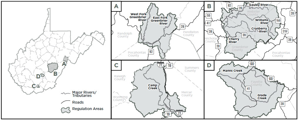
NOTE: Baitfish regulation 2 (see below) applies to the shaded areas illustrated on the maps above.
Baitfish Regulations
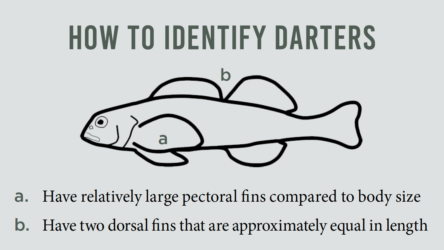
1. It is illegal to possess any darter in West Virginia
Darters are small fishes (1–5" in length) that belong to the perch family with yellow perch and walleye. Although much smaller, darters share similar characteristics to their gamefish cousins, such as having two separate dorsal (top) fins that are approximately equal in length. Anyone collecting live baitfish is advised to inspect their catch for darters. Generally, darters will stay on the bottom of the bait bucket and do not swim freely in the water column. Any fishes displaying this bucket behavior and possessing two dorsal fins should be either returned at onceinto the waters where they were collected or destroyed immediately. Darter colorations can range from brightly colored to drab brown. See examples of regional darter species here: (efish.fishwild.vt.edu/families/percidae.html). When in doubt, throw it out!
2. Zero possession limit for all non-game fishes (including their collection for any use); and no fish, including dead/packaged minnows, may beused as bait in the following waters:
- East and West Forks of the Greenbrier River including all tributaries.
- Gauley River upstream of the Route 55/20 bridge (i.e., Curtin, W.Va.) including the Cherry, Williams, Cranberry, and upper Gauley rivers and all respective tributaries.
- Camp Creek (Mercer County) and all tributaries.
- Manns Creek including Glade Creek in Babcock State Park and all tributaries.
NOTE: These areas are delineated on the maps above.
3. It is illegal to release any fish into public waters other than the location where it was captured.
DO NOT release unused baitfish.
Other Protected Species
DIAMOND DARTER
- The diamond darter is a small fish found in the perch family and is protected under the Federal Endangered Species Act.
- For more information, go to USFWS site at fws.gov/species/search
PADDLEFISH AND STURGEON
All fish must be returned to the water immediately.
ALL MUSSEL SPECIES
It is illegal to possess mussels or any parts thereof.
Turtle, Frog, Toad and Salamander Regulations
The take or possession of any native West Virginia reptile or amphibian species not listed hereafter is prohibited pursuant to W.Va. Code 20-2-4.
Turtles
COMMON NAME | SCIENTIFIC NAME |
| Snapping turtle | Chelydra serpentina |
Spiny softshell | Apalone s. spinifera |
Turtles may be taken by gigging, snagging or snaring from Jan. 1 through May 15 and from July 15 through Dec. 31. The daily creel limit for snapping turtles and spiny softshells is 10, with a possession limit of 20. | |
Frogs and Toads
Residents and nonresidents may take or possess green and American bullfrogs.
COMMON NAME | SCIENTIFIC NAME |
American bullfrog | Lithobates catesbeianus |
Green frog | Lithobates clamitans |
Frog season open at 9 p,m. on the Saturday nearest to June 15 and closes at midnight on July 31. The daily creel limit for American bullfrog and green frog is 10, with a possession limit of 20. | |
Salamanders
A person may take the following salamanders year-round for use as fishing bait.
Possession Limit: 10 in aggregate Season: Open | |
COMMON NAME | SCIENTIFIC NAME |
Northern dusky salamander | Desmognathus fuscus |
Seal salamander | Desmognathus monticola |
Allegheny dusky salamander | Desmognathus ochrophaeus |
Black-bellied salamander | Desmognathus quadramaculatus |
Black Mountain salamander | Desmognathus welteri |
Northern spring salamander | Gyrinophilus p. porphyriticus |
Kentucky spring salamander | Gyrinophilus p. duryi |
Northern two-lined salamander | Eurycea bislineata |
Southern two-lined salamander | Eurycea cirrigera |
Eastern long-tailed salamander | Eurycea l. longicauda |
Licensed bait dealers may possess 250 salamanders in total aggregate from species listed in table. A person may have in his or her possession no more than 50 salamanders which are purchased from a licensed dealer and accompanied by a bill of sale pursuant to W. Va. Code of State Rules, Title 58 Series 62, Bait Fish Rule. | |
For more information about West Virginia Reptile and Amphibian Regulations, go to WVdnr.gov.
Crayfish Regulations
- A fishing license is required to catch or use crayfish from public lands as fishing bait.
- Licensed anglers may take or have in his or her possession no more than 50 crayfish for use as fishing bait.
- A seine, throw net or minnow trap may be used to obtain crayfish for use as fishing bait provided the seine, throw net or minnow trap meet certain specifications. (See Seining for Aquatic Life/Minnow Traps)
- It is illegal to dig crayfish out of its burrow or place of refugefor use as fishing bait, pursuant to W.Va. Code 20-2-5. A crayfish may be taken by hand for use as fishing bait from the stream it was captured.
- It is illegal to release any aquatic organism including crayfish, alive or dead, used or unused, into public waters other than the location where it was captured, pursuant to W.Va. Code 20-2-64.
Except as authorized below, it is illegal to take fish by any means other than by rod, line and hooks.
IT IS ILLEGAL TO:
- use a firearm, crossbow, dynamite or any like explosive, or a poisonous mixture placed in the water for the purpose of killing or taking fish, frogs, aquatic turtles or other forms of aquatic life.
- use any free-floating device (jug fishing) used to deploy a hook and line.
- fish with more than two (2) lines or poles in an impoundment stocked with trout by the WVDNR from January 1 – May 31.
- stock fish in the waters of West Virginia. Please do not release unused bait into West Virginia waters.
- sell any fish for profit
- sell or give any fish caught in public waters to a pay pond.
- improperly dispose of, leave on a bank or in the water fish taken while bow fishing.
- fish within 200 feet of Division of Natural Resources personnel who are stocking fish in public waters.
Bow Fishing
Bow fishing for game fish is not permitted. A complete list of gamefish is on the back cover of the regulations. Only common carp, bighead carp, silver carp and grass carp may be taken by bow year-round; smallmouth buffalo are not carp and cannot be shot year-round. Other nongame fish may be taken by bow during all months of the year except May and June. All anglers must have a valid fishing license in order to fish using a bow. All persons using a bow to fish must observe all applicable fishing regulations. Fish taken by bow fishing may not be returned to the water or left on the bank.
IT IS ILLEGAL TO:
- use an arrow having an explosive head or shaft or an arrow dipped in or smeared with poison or other chemicals.
Dipping
Dipping for nongame fish is legal year-round with a valid West Virginia fishing license. A dip net may not exceed 36 square feet in overall area, and its mesh may not be smaller than one-fourth (1/4) inch.
Gigging, Snagging and Snaring
Suckers, carp, fallfish and creek chubs may be taken by snaring yearround. Nongame fish, certain turtles (see Turtles, Frogs, Toads and Salamander Regulations on page 11) and eels may be taken by gigging, snagging, or snaring from January 1 – May 15 and from July 15 – December 31, except that snagging and gigging shall be prohibited within 100 feet of all U.S. Army Corps of Engineers Locks and Dams and their appurtenances. Snagging of game fish is prohibited.
Hand-Fishing for Catfish
It is legal to hand-fish or “noodle” only for catfish in West Virginia public waters from June 15 to Aug. 31 with fishing permitted from sunrise to sunset. See page 5 for more details.
Hatchery Fish Removal
IT IS ILLEGAL TO:
- • take fish, frogs, aquatic turtles or other aquatic life from a state fish hatchery.
Ice Fishing
Holes cut for ice fishing must be no larger than 10 inches in diameter. This applies to public waters where ice fishing is allowed.
Seining for Minnows/ Minnow Traps
Game fish may not be seined or trapped. A seine may be used to obtain minnows for use as bait provided the seine is not longer than eight feet nor deeper than four feet. A thrownet may be used provided the radius is no larger than 12 feet and mesh size no larger
than one (1) inch. Minnow traps may be used provided the openings are not larger than one inch in diameter. A person may have in
his possession no more than 50 minnows nor more than a total of 100 aquatic animal life (see Turtles, Frogs, Toads and Salamander) unless obtained from a licensed dealer and a bill of sale is provided. A valid West Virginia fishing license is needed to collect minnows and other aquatic life. Minnow traps must be tagged with a waterproof, legible tag bearing either the owner’s name and address or his or her WVDNR identification number. Minnow traps must also be checked once every 24 hours.
Trotlines and Droplines
Trotlines and droplines must be attached to the bank or a tree thereon, must bear an identification tag that is legible and waterproof, and must be attended every 24 hours. The tag must either bear the owner’s name and address or his or her WVDNR identification number. Wire or cable lines and hooks with more than one point are prohibited.
IT IS ILLEGAL TO:
- • fish with trotlines and droplines in state-managed impoundments except Stonecoal, Hawks Nest, Mt. Storm, Cheat and U.S. Army Corps of Engineers lakes
- • attach a trotline to public piers and docks or within 50 feet of dam appurtenances
- • use droplines on the Elk River, Hughes River, Little Kanawha River, Middle Island Creek, and South Fork of Hughes River
Spearfishing and Diving
- Nongame fish may be taken by spearfishing from July 1 – September 30 during daylight hours only. Gamefish are not permitted to be taken while spear fishing. A complete list of gamefish is on the back cover of the regulations.
- Spearfishing is prohibited on the following:
- Elk River, from Sutton Dam downstream to the U.S. Route 19 bridge at Sutton;
- New River, from Bluestone Dam downstream to the lower bridge at Hinton.
- Spearguns may be discharged only beneath the surface of the water.
- It is illegal to use a bolt having an explosive head or shaft or a bolt dipped in or smeared with poison or other chemicals.
- A diver may not spearfish in such a manner as to interfere with other anglers.
- A diver may not spearfish in heavily traveled boat lanes, marked swimming areas or marked waterskiing areas.
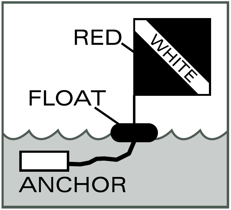
- “Diver down flag” shall be a red field of not less than 10 inches x 10 inches dimension with a white diagonal stripe not less than 1.5 inches wide running upper left to lower right. The flag shall be displayed at all times and be affixed to a separate flotation device. No such flag shall be attached to any navigational device or placed so as to obstruct boat traffic. Divers must come up within 100 feet of flag. All powerboats will remain a minimum distance of 100 feet away from the marker flag. The top of the flag shall be at least 3 feet above the surface of the water.
- Fish taken by spearfishing may not be returned to the water or left on the bank.
Wanton Waste
It is illegal for any person to cause through carelessness, neglect or otherwise to let any edible portion of any game fish to go to waste needlessly. The edible portion is the fillet meat from the gill plate to the tail fin. Edible meat does not include bones, sinew, viscera, meat from the head or neck, meat that has been damaged or rendered inedible by method of taking, or meat that is reasonably lost as a result of boning or close trimming of bones.
Any person violating the provisions of this section is guilty of a misdemeanor and, upon convection thereof, shall be subject to a fine of not less than $100 nor more than $500, or confinement in jail not less than 10 days nor more than 100 days, or both fined and confined; suspension of hunting and fishing license for a period of two years; and a applicable forfeiture and replacement provisions in Chapter 20, Article 2, Section 5a of the code.
Trout Stocking Lakes and Ponds
| Code | No. Stockings | Period |
| Q | One | 1st week of March |
| W | One | One January |
| Two | February | |
| One each week | March – May | |
| X | After April 1 or area is open to public | |
| BW | Two each month | February – April |
| One | May | |
| BA | One January | One January |
| One March | One March | |
| CR or DH | Varies Varies | Varies Varies |
| M | One each month | February – May |
| MJ | One each month | January – April |
| Y | One | April |
| F | One each week | weeks of October 16 and 23 |
| Lake or Pond | County | Code |
| Anawalt | McDowell | M |
| Anderson | Kanawha | BA |
| Baker | Ohio | Q |
| Barboursville | Cabell | BA |
| Bear Rock Lakes | Ohio | BW |
| Berwind | McDowell | M |
| Big Run | Marion | Y |
| Boley | Fayette | M |
| Brandywine | Pendleton | BW-F |
| Brushy Fork | Pendleton | BW |
| Buffalo Fork | Pocahontas | BW-F |
| Cacapon | Morgan | W-F |
| Castleman Run | Brooke, Ohio | BW |
| Cedar Creek | Gilmer | BA |
| Chief Cornstalk | Mason | BA |
| Chief Logan | Logan | MJ |
| Conaway Run | Tyler | MJ |
| Coonskin Park | Kanawha | Q |
| Coopers Rock | Monongalia | BW-F |
| Curtisville | Marion | MJ |
| Deegan Lake | Harrison | MJ |
| Dog Run | Harrison | M |
| Edwards Run | Hampshire | BW |
| Fitzpatrick | Raleigh | MJ |
| Ft. Ashby | Mineral | BW |
| French Creek | Upshur | BW |
| Handley | Pocahontas | Q |
| Hinkle Lake | Harrison | MJ |
| Horse Creek | Wyoming | M |
| Huey Run | Marion | BA |
| Hurricane Water Supply | Putnam | MJ |
| Indian Rocks Lake | Nicholas | M |
| James P. Bailey | Mercer | BA |
| Jimmy Lewis | Mercer | M |
| Kanawha State Forest | Kanawha | Q |
| Kimsey Run | Hardy | BW |
| Krodel | Mason | BA |
| Larenim | Mineral | BA |
| Laurel | Mingo | MJ |
| Lick Creek | Wayne | MJ |
| Little Beaver | Raleigh | MJ |
| Logan County Airport | Logan | Q |
| Mason Lake | Monongalia | M |
| Middle Wheeling Creek | Ohio | BW |
| Miletree | Roane | BA |
| Mill Creek | Barbour | M |
| Millers Fork | Wayne | Q |
| Mountwood | Wood | MJ |
| Newburg | Preston | M |
| New Creek Dam 14 | Grant | BW-F |
| Pendleton | Tucker | MJ-F |
| Pennsboro W. S. Reservoir | Ritchie | BA |
| Pipestem | Summers | M |
| Poorhouse | Berkeley | M |
| Raleigh County Airport | Raleigh | Q |
| Ridenour | Kanawha | BA |
| Rock Cliff | Hardy | XBW-F |
| Rockhouse | Logan | M |
| Rollins | Jackson | MJ |
| Seneca | Pocahontas | BW-F |
| South Mill Creek | Grant | BW |
| Spruce Knob | Randolph | W-F |
| Summit | Greenbrier | W-F |
| Teter Creek | Barbour | BW-F |
| Thomas Park | Tucker | MJ |
| Tomlinson Run | Hancock | MJ |
| Tracy | Ritchie | BA |
| Tuckahoe | Greenbrier | M |
| Turkey Run | Jackson | BA |
| Underwood | Cabell | Q |
| Wallback | Clay, Roane | M |
| Warden | Hardy | BW |
| Watoga | Pocahontas | W-F |
| Wayne Dam | Wayne | MJ |
| Westover Park | Monongalia | Q |
Streams Trout Stocking
| Stream | County | Code |
| Anthony Creek | Greenbrier | W-F |
| Back Fork of Elk River | Webster | M |
| Back Fork of Elk River (C & R) | Webster | CR |
| Beech Fork Lake (Tailwaters) | Wayne | M |
| Bullskin Run | Jefferson | W |
| Big Clear Creek | Greenbrier | BW-F |
| Big Sandy Creek | Preston | BW |
| Blackwater River | Tucker | W-F |
| Blackwater River (C & R) | Tucker | CR |
| Buckhannon River | Upshur | BW-F |
| Buffalo Creek | Brooke | BW |
| Buffalo Creek | Clay | M |
| Buffalo Creek | Logan | M |
| Burnsville Lake (Tailwaters) | Braxton | BW |
| Camp Creek | Mercer | BW |
| Cherry River | Nicholas | BW |
| Clear Fork | McDowell | M |
| Clear Fork | Wyoming | BW |
| Clear Fork (C & R) | Wyoming | DH |
| Clover Run | Tucker | M |
| Nicholas, Pocahontas, Webster | ||
| Cranberry River | W-F | |
| Cranberry River (C & R) | Pocahontas, Webster | CR |
| Deer Creek | Pocahontas | M |
| Desert Fork | Webster | M |
| Dillions Run | Hampshire | BW |
| Dry Fork | McDowell | M |
| Dry Fork | Randolph, Tucker | BW |
| Dunloup Creek | Fayette | M |
| East Fork of the Greenbrier River | Pocahontas | W |
| East Lynn Lake (Tailwaters) | Wayne | M |
| East River of New River | Mercer | BW |
| Elk River | Randolph, Webster | W-F |
| Elk River (C & R) | Randolph | CR |
| Evitts Run | Jefferson | W-F |
| Gandy Creek | Randolph | W |
| Glade Creek (Babcock) | Fayette | BW |
| Glade Creek of New River | Raleigh | BW-F |
| Glady Fork | Randolph | W |
| Greenbrier River (Cass) | Pocahontas | M |
| Greenbrier River | Pocahontas | BW |
| Greenbrier River (Marlinton Section) | Pocahontas | MJ |
| Hills Creek | Pocahontas | M |
| Hopkins Fork | Boone | M |
| Horseshoe Run | Tucker | BW |
| Howard Creek | Greenbrier | MJ |
| Indian Creek of New River | Summers | M |
| Kings Creek | Hancock | MJ |
| Knapps Creek | Pocahontas | W-F |
| Laurel Creek | Fayette | M |
| Laurel Creek | Greenbrier, Nicholas | M |
| Laurel Fork | Randolph | W |
| Laurel Fork | Webster | BW |
| Laurel Fork | Wyoming | Q |
| Left Fork of Buckhannon River | Upshur | M |
| Left Fork of Holly River | Webster | BW |
| Left Fork of Right Fork Buckhannon | Randolph, Upshur | BW |
| Little Clear Creek | Greenbrier | BW |
| Little Kanawha River (Headwaters) | Upshur | M |
| Little River (East Fork) | Pocahontas | W |
| Little River (West Fork) | Pocahontas | W |
| Lost River | Hardy | W-F |
| Marsh Fork | Raleigh | M |
| Mash Fork | Mercer | BW-Q |
| Meadow Creek | Greenbrier | M |
| Meadow Creek | Summers | M |
| Middle Creek | Berkeley | W |
| Middle Fork | Barbour, Randolph, Upshur | M |
| Middle Wheeling Creek (C&R) | Ohio | DH |
| Mill Creek | Berkeley | W |
| Mill Creek | Fayette | M |
| Mill Creek | Hampshire | BW |
| Moores Run | Hardy | M |
| New Creek | Mineral | W |
| North Branch of Potomac River | Mineral | M-F |
| North Bend Lake (Tailwaters) | Ritchie | MJ |
| North Fork of Fishing Creek | Wetzel | MJ |
| North River | Hardy | BW |
| North Fork of Cherry River | Greenbrier, Nicholas | BW |
| North Fork of Lunice Creek | Grant | BW |
| North Fork of Patterson Creek | Grant | W |
| North Fork of South Branch | Grant, Pendleton | W-F |
| North Fork of South Branch (C & R) | Pendleton | CR |
| Opequon Creek | Berkeley, Jefferson | W-F |
| Paint Creek | Fayette, Kanawha | BW |
| Paint Creek (C & R) | Fayette | CR |
| Panther Creek | McDowell | M |
| Paw Paw Creek | Marion | BW |
| Pinch Creek | Raleigh | Y |
| Pinnacle Creek | Wyoming | BW-F |
| Pond Fork | Boone | BW-F |
| Potts Creek | Monroe | M |
| R.D. Bailey Lake (Tailwaters) | Mingo, Wyoming | BW-F |
| Red Creek | Tucker | BW |
| Rhine Creek | Preston | M |
| Rich Creek | Monroe | M |
| Right Fork of Buckhannon River | Upshur | M |
| Right Fork of Middle Fork | Upshur | M |
| Right Fork of Little Kanawha River | Upshur, Webster | M |
| Rocky Marsh Run | Jefferson | W |
| Second Creek (C & R) | Greenbrier, Monroe | CR |
| Shavers Fork (C & R) | Randolph | CR |
| Shavers Fork (Lower C & R) | Randolph | CR |
| Shavers Fork (Lower Section) | Randolph | W-F |
| Shavers Fork (Upper Section) | Randolph | W-F |
| South Branch (Franklin Section) | Pendleton | W-F |
| South Branch (Smoke Hole Section) | Pendleton | W-F |
| South Branch (C & R) | Pendleton | CR |
| South Fork of Cherry River | Greenbrier, Nicholas | BW |
| South Fork of Cranberry River | Pocahontas | MJ |
| South Fork of Fishing Creek | Wetzel | MJ |
| Spruce Laurel Fork | Boone | M |
| Stonewall Jackson Lake (Tailwaters) | Lewis | BW |
| Sugar Creek | Webster | M |
| Summersville Lake (Tailwaters) | Nicholas | BW-F |
| Sutton Lake (Tailwaters) | Braxton | BW-F |
| Tilhance Creek | Berkeley | BW |
| Tomlinson Run | Hancock | MJ |
| Trout Run | Hardy | W |
| Tuscarora Creek | Berkeley | BW |
| Twelvepole Creek | Wayne | MJ |
| Tygart Lake (Tailwaters) | Taylor | M-F |
| Tygart Valley River (Headwaters) | Randolph | BW-F |
| Waites Run | Hardy | W |
| West Fork of Greenbrier River | Pocahontas | W-F |
| West Fork of Twelvepole Creek | Wayne | M |
| Wheeling Creek | Marshall, Ohio | BW |
| Whiteday Creek | Marion, Monongalia | BW |
| Williams River | Pocahontas, Webster | W-F |
| Williams River (C & R) | Pocahontas | CR |
Public Lakes and Ponds
Key
• = the listed feature or activity is available or permitted.
A blank space indicates the feature or activity IS NOT available or permitted.
LAKE OR POND
* = National Forest Stamp required
COE = U.S. Army Corps of Engineers lake
ACCESSIBILITY
USE OF LIVE MINNOWS NIGHT FISHING
C = registered campers only
P = permit required
CAMPING
L = limited primitive
P = permit required
BOATING
NV = no vessels
NM = no motor boats
E = electric motors only
U = unlimited h.p.
5 = 5 h.p. maximum
10 = 10 h.p. maximum (Larger motors must have props removed or motor tilted to the maximum limit.)
* = contains no-wake zones, speed zones and/or other restricted areas (At Upper Mud Lake, all motors greater than 10 h.p. must operate at no wake speed at all times.)
f = fee charged for private boats, May 30 ‒ Labor Day
Rental Boats - check with individual facilities
A USCG approved life preserver is required for each occupant of ALL BOATS. See West Virginia Boating Regulations. All boats propelled by machinery must be licensed.
Lake or Pond | County | Accessibility | Acres | Use of Live Minnows | Night Fishing | Camping | Boating |
Airport Pond | Raleigh | • | 1 | NV | |||
Anawalt | McDowell | • | 6 | • | NV | ||
Anderson | Kanawha | • | 5 | • | NV | ||
Baker | Ohio | • | 2 | • | NV | ||
Barboursville | Cabell | • | 14 | P | NV | ||
Bear Rock Lakes | Ohio | • | 10 | • | E | ||
Beech Fork COE | Wayne | • | 720 | • | • | P | 10* |
Berwind | McDowell | • | 17 | • | P | E | |
Big Ditch | Webster | • | 65 | • | E | ||
Big Run | Marion | 7 | • | • | E | ||
Bluestone COE | Summers | • | 2,040 | • | • | P | U* |
Boley | Fayette | • | 17 | • | P | E | |
Brandywine* | Pendleton | • | 9 | • | P | E | |
Brushy Fork | Pendleton | 23 | • | E | |||
Buffalo Fork* | Pocahontas | • | 22 | • | E | ||
Burnsville COE | Braxton | • | 968 | • | • | P | U* |
Cacapon | Morgan | • | 12 | • | NMf | ||
Cameron | Marshall | 7 | • | • | NV | ||
Camp Run* | Pendleton | 9 | • | E | |||
Castleman Run | Brooke, Ohio | • | 14 | • | • | E | |
Cedar Creek | Gilmer | 10 | • | • | P | NV | |
Charles Fork | Roane | • | 65 | • | E | ||
Cheat Lake | Monongalia | • | 1,730 | • | • | U* | |
Chief Cornstalk | Mason | • | 4 | • | P | E | |
Chief Logan | Logan | • | 6 | • | NV | ||
Conaway Run | Tyler | • | 31 | • | P | E | |
Coonskin Park | Kanawha | • | 2 | NV | |||
Coopers Rock | Monongalia | • | 5 | • | P | NV | |
Curtisville | Marion | • | 29 | • | • | P | E |
Deegan | Harrison | • | 15 | • | E | ||
Dents Run | Marion | 29 | • | E | |||
Dixon | Monongalia | • | 6 | • | NV | ||
Doe Run | Taylor | 18 | • | • | P | E | |
Dog Run | Harrison | 23 | • | E | |||
Dunkard Fork | Marshall | 30 | • | • | E | ||
East Lynn COE | Wayne | • | 1,005 | • | • | P | U* |
Edwards Run | Hampshire | 1 | • | L | NV | ||
Elk Fork | Jackson | • | 209 | • | • | 10 | |
Elk Two Mile (Site12) | Kanawha | 2 | NV | ||||
Elk Two Mile (Site13) | Kanawha | 3 | NV | ||||
Elk Two Mile (Site14) | Kanawha | 3 | NV | ||||
Elkwater Fork | Randolph | 50 | • | • | U | ||
Fairfax | Preston | 47 | • | • | E | ||
Fitzpatrick | Raleigh | 5 | P | P | NV | ||
Flat Run | Marion | 5 | • | • | E | ||
Ft. Ashby | Mineral | 15 | • | • | E | ||
French Creek | Upshur | 2 | NV | ||||
Frozencamp Left Fork | Jackson | 16 | • | E | |||
Frozencamp Right Fork | Jackson | 19 | • | E | |||
Handley Pond | Pocahontas | • | 6 | • | P | E | |
Hawks Nest | Fayette | 234 | • | • | U* | ||
Hinkle | Harrison | • | 6 | • | E | ||
Horse Creek | Wyoming | 8 | • | E | |||
Huey Run | Marion | 18 | • | • | E | ||
Hurricane W.S. Reservoir | Putnam | • | 13 | • | NV | ||
Indian Rock | Nicholas | • | 3 | NV | |||
James P. Bailey | Mercer | • | 28 | NV | |||
Jennings Randolph COE | Mineral | 952 | • | • | P | U* | |
Jimmy Lewis | Mercer | • | 13 | • | E | ||
Kee Reservoir | Mercer | 62 | • | E | |||
Kimsey Run | Hardy | • | 47 | • | E | ||
Krodel | Mason | • | 21 | • | P | E | |
Larenim | Mineral | • | 9 | • | NM | ||
Laurel | Mingo | • | 22 | • | E | ||
Lick Creek | Wayne | 4 | • | • | NV |
Lake or Pond | County | Accessibility | Acres | Use of Live Minnows | Night Fishing | Camping | Boating |
Little Beaver | Raleigh | • | 18 | • | P | E | |
Logan County Airport | Logan | • | 1 | NV | |||
Mason Lake | Monongalia | • | 9 | • | • | E | |
McClintic Ponds | Mason | • | 211 | • | P | E | |
Middle Wheeling Creek | Ohio | 12 | • | • | E | ||
Miletree | Roane | 10 | • | E | |||
Mill Creek | Barbour | • | 9 | E | |||
Millers Fork | Wayne | • | 5 | NV | |||
Moncove | Monroe | • | 93 | • | P | 5 | |
Mount Storm | Grant | 1,170 | • | • | U* | ||
Mountain Valley | Summers | 38 | E | ||||
Mountwood | Wood | • | 41 | • | P | E | |
Newburg Lake | Preston | 6 | NV | ||||
New Creek Dam 14 | Grant | 39 | • | E | |||
North Bend Lake | Ritchie | • | 235 | • | • | P | 10 |
North Bend SP Pond | Ritchie | 1.5 | C | P | NV | ||
O’Brien | Jackson | 197 | • | • | 10 | ||
Parker Hollow | Hardy | 34 | • | E | |||
Pendleton | Tucker | 10 | P | NM | |||
Pennsboro W.S. Reservoir | Ritchie | 9 | • | E | |||
Pettigrew | Kanawha | • | 5 | NM | |||
Pipestem | Summers | • | 18 | • | P | E | |
Plum Orchard | Fayette | • | 175 | • | P | U* | |
Poorhouse Pond | Berkeley | 3 | NV | ||||
R.D. Bailey COE | Mingo, Wyoming | 630 | • | • | P | U* | |
Raleigh County Airport | Raleigh | • | 2 | NV | |||
Ridenour | Kanawha | • | 23 | • | NM | ||
Rock Cliff* | Hardy | • | 12 | C | P | E | |
Rockhouse | Logan | • | 11 | • | E | ||
Rollins | Jackson | • | 41 | • | E | ||
Salt Lick Pond 9 | Braxton | 15 | • | • | E | ||
Seneca | Pocahontas | • | 6 | • | P | E | |
Sherwood* | Greenbrier | 161 | P | P | E | ||
Silcott Fork | Roane | 17 | • | NV | |||
Sleepy Creek | Berkeley | • | 209 | • | • | P | E |
South Mill Creek | Grant | • | 40 | • | E | ||
Spruce Knob* | Randolph | • | 26 | • | P | E | |
Stephens | Raleigh | • | 276 | • | P | U* | |
Stonecoal | Lewis, Upshur | • | 539 | • | • | P | 10* |
Stonewall Jackson COE | Lewis | • | 2,650 | • | • | P | U* |
Summersville COE | Nicholas | • | 2,790 | • | • | P | U* |
Summit* | Greenbrier | • | 37 | • | P | E | |
Sutton COE | Braxton | • | 1,440 | • | • | P | U* |
Teter Creek | Barbour | • | 36 | • | P | E | |
Thomas Park | Tucker | 22 | • | • | L | E | |
Tomlinson Run | Hancock | 23 | • | • | P | E | |
Tracy | Ritchie | 12 | • | L | E | ||
Trout Pond | Hardy | 1 | • | P | NV | ||
Tuckahoe | Greenbrier | • | 43 | • | E | ||
Turkey Run | Jackson | • | 24 | • | • | E | |
Turkey Run | Marshall | 15 | • | • | E | ||
Tygart COE | Taylor | • | 1,750 | • | • | P | U* |
Tygart River Backwaters | Randolph | • | 58 | • | • | E | |
Underwood Lake | Cabell | • | 1 | NV | |||
Upper Cover Run | Hardy | 6 | • | E | |||
Upper Deckers | Preston | 10 | E | ||||
Upper Mud | Lincoln | • | 237 | • | • | U* | |
Wallback | Clay | • | 14 | E | |||
Warden | Hardy | • | 46 | • | E | ||
Watoga | Pocahontas | • | 12 | • | P | E | |
Westover Park | Monongalia | • | 1 | NV | |||
Whetstone | Marion | 8 | • | • | E | ||
Wolf Run | Marshall | 17 | • | E | |||
Woodrum | Jackson | • | 237 | • | • | 10 |
Rules and Regulations Governing Public Use of West Virginia Fishing and Boating Access Sites
Article 1, Section 7, Chapter 20 of the Code of West Virginia, 1961 as amended, the following rules and regulations govern public use of all fishing and boating access sites administered by the Division of Natural Resources, Wildlife Resources Section.
REQUIREMENTS AND PROHIBITIONS:
- Public boating and fishing access facilities shall be used solely for the purpose of launching and retrieving watercraft or fishing from the shore. Fishing from courtesy docks or ramps is not permitted. No other use of access sites is allowed.
- After launching, vehicles shall be parked in available parking spaces.
- Any law enforcement officer acting under proper authority may prohibit an individual from launching a watercraft from any public boating and fishing access sites.
- The following are prohibited at fishing and boating access sites:
- Consumption of alcoholic beverages or possession of an open container of alcoholic beverages.
- Swimming or bathing.
- Camping.
- Open fires.
- Trash disposal except where trash receptacles are provided.
- Discharge of firearms, fireworks and explosives.
- Leaving unattended watercraft.
- Commercial use except as authorized by the Director.
- Parking of any vehicle or the mooring of any watercraft in such a manner as to obstruct any avenue of ingress or egress, except for the purpose of launching.
Any person violating any of these rules and regulations shall be punished in accordance with the provisions of Chapter 20 of the Code of West Virginia and such other laws as may be applicable.
It is the policy of the Division of Natural Resources to provide its facilities, accommodations, services and programs to all persons without regard to sex, race, age, religion, national origin or ancestry, disability or other protected group status. The Division of Natural Resources is an equal opportunity employer.
Boating and Water Safety
Boating Education Requirement
Anglers using boats must obey boating laws. In West Virginia, anyone born on or after December 31, 1986, must successfully complete a NASBLA-approved Boating Education Course before operating a motorboat.
Contact a Natural Resources Police Officer for an available course near you. You can also take the online Boating Education Course available at WVdnr.gov. Click on boating under the Law Enforcement heading.
Personal Flotation Device (PFD)
Most boating fatalities are the result of a boat capsizing or passenger falling overboard. Nearly 80 percent of those who died in boating accidents were NOT wearing a PFD.
If you are fishing from a vessel, West Virginia law requires that you have a PFD (life jacket) that is in good condition, properly sized and readily available for each person on board. Any child under the age of 13, including infants, must wear a PFD while the vessel is underway. Vessels 16 feet and over must have a throwable Type IV PFD ring or cushion on board that can be thrown to a person
in the water in addition to the previously stated PFDs. Tygart and Stonewall Jackson lakes have a federal regulation requiring
mandatory wearing of PFDs regardless of age on all vessels under 16 feet, including kayaks and paddleboards.
Courtesy on the Boat Ramp
Boat ramp traffic jams can be prevented if everyone practices common courtesy at the ramp. Be sure you observe these simple courtesies.
- • Prepare your vessel for launching or for the drive home well away from the ramp.
- • Use at least two experienced people to launch and retrieve the vessel (one to drive the towing vehicle and one to operate the vessel).
- Never block a ramp with an unattended vessel or vehicle.
- • Move the vessel away from the launch lane immediately after removing it from the trailer. Return briefly to pick up the vehicle driver once he or she has parked the vehicle and is back at the ramp.
- • When retrieving, do not pull your vessel into a launch lane until the towing vehicle is at the ramp. The line is formed by vehicles with trailers, not by vessels in the water. Drop off the vehicle driver, and wait offshore and clear of the ramp until he or she arrives with the trailer.
Learn more about boating safety at www.register-ed.com or take an online course at WVdnr.gov.
Safe Boating Rules
Boating accidents usually result from a collision with another boat or an object in the water such as rocks or pilings. A little boating knowledge, common sense and courtesy could prevent most accidents.
Don’t operate a boat under the influence of alcohol or drugs.
- Don’t overload the boat.
- Don’t sit on the edge of the boat.
- If you must stand up, do so carefully away from the sides.
- Drive at a safe speed.
- Use navigation lights at night.
- Keep a lookout for other boats and follow the rules of navigation.
- • Always let someone know where you are going and when you plan to return.
Don’t fish during a thunderstorm.
Every vessel or watercraft must carry the proper safety equipment. A vessel means every description of watercraft, other than seaplane on the water, used or capable of being used as a means of transportation on water. Examples of watercraft include kayaks, canoes, inflatable pontoon boats and other vessels.
Check the weather conditions before you leave. Lightning, strong wind and high waves create hazardous conditions. If caught on a lake in a strong storm, put all fishing gear in the bottom of the boat, stay low in the boat and get off the water as soon as possible. In high waves, the best way to keep from capsizing is to steer the boat at a slight angle into the waves.
ALCOHOL AND DRUGS
Operating a boat under the influence of alcohol or drugs creates the same risks and carries the same penalties as DUI. Intoxication affects your balance, which is already challenged by being in a boat. It also affects your coordination, vision and thinking ability. Alcohol also causes you to lose body heat faster should you fall into the water, increasing the risk of hypothermia. A blood alcohol concentration of 0.08 or above qualifiesas legally intoxicated.
COMMERCIAL RIVER TRAFFIC
While boating on the major rivers of West Virginia, always be alert for large commercial vessels. Large vessels always have the right-of-way because of long stopping distances and blind spots around them. Also, turbulent water around the large vessel could capsize a small boat easily.
Stay out of danger zones and restricted areas around locks and dams.
Person in the Water
Fishing in Cold Weather
Reach-Throw-Row-Go is a method of rescuing a person who is in trouble in water. If the person is close to you, REACH out with a long object such as an oar or tree limb to pull the person into shore or the boat.
If you can’t reach the person, then THROW them a life-saving device. If possible, it should be tied to the end of a line so you can pull the person to you. An inflatable ball or foam cooler can be used if the proper device is not available.
If there is nothing to throw, ROW a boat to the person in trouble. The person should be pulled in over the stern, or back, of the boat if possible to prevent the boat from tipping over. If the boat has a motor, it must be shut off before you get to the person in the water.
GO (swim) to the person ONLY as a last resort and only if you have had life-saving training. People who are drowning often panic and injure or drown someone trying to rescue them.
Safety with Fishing Equipment
Fishing hooks can be dangerous if not handled properly. Look behind you before you cast to make sure your hook will not be caught on a power line, a tree or a person. Do not leave fishing tackle lying loose on the ground. Someone can trip on it and fall or step on a hook.
Hypothermia
Hypothermia is a condition in which your body loses heat faster than it can produce it. Without treatment, your life is in danger. Exposure to the cold along with wind, wetness and exhaustion causes hypothermia. A common misconception is that the air or water temperature must be below freezing before you can become hypothermic. Actually, many cases of hypothermia develop in air temperatures between 30 and 50 degrees. And because water takes away body heat 25 times faster than air of the same temperature, any water colder than 70 degrees can cause hypothermia.
Symptoms of hypothermia include uncontrollable shivering, fumbling hands, slow speech, confusion and exhaustion. To treat hypothermia, get the victim out of the cold, give warm drinks, keep the person awake, remove all wet clothing and get the victim into dry clothes.
To stay warm, wear several layers of clothing. Air trapped between the layers serves as insulation. A wool hat prevents heat loss from your head. Fishing is difficult with most gloves, but lightweight rubber gloves, gloves without fingertips, and gloves that have a flap to expose your fingers allow greater manual dexterity.
Ice fishing
West Virginia doesn’t possess numerous ice fishing opportunities and in some ways, that makes the sport a little riskier. Anglers may be tempted to venture out on a frozen lake or river before checking the thickness of the ice. Ice should be at least four inches thick before it is considered safe. Due to variations in ice thickness on a waterbody, extreme caution should be exercised.
Wading
There are several rules you should follow for safe wading.
Wade with a fishing buddy.
- Wear your PFD.
- Find out whether the bottom is rocky or muddy.
- Shuffle your feet or probe with a stick along the bottom to avoid holes.
- Study how swiftly the water is moving.
- Wear appropriate footwear (considering water temperature and bottom substrate).
Aquatic Invasive Species
Aquatic invasive species are an ever-increasing threat to aquatic ecosystems across the country and in West Virginia waters.
Species such as Asian carp, northern snakehead, rusty crayfish, zebra mussels, didymo and hydrilla have had impacts on and are threatening native fishes of not only West Virginia waters but the Great Lakes, and Ohio and Mississippi River basins. Recreational impacts and economic costs associated with invasive species can be substantial if invasive species do become a problem. Informing
anglers of these threats and how they can help are our best and first line of defense to guard against invasive species.
What anglers can do:
- NEVER move fish from one body of water to another.
- Drain live wells thoroughly before leaving an access area.
- Allow all equipment to dry completely before moving
between waterbodies.
- • Dispose of ALL unwanted bait into a trash receptacle; do not release bait into lakes or streams.
- Do not release aquarium fish into West Virginia’s waters.
- • Report sightings. Take a picture, note the location and report new sightings to [email protected] or WVdnr.gov.
By following these simple steps, anglers can help ensure
West Virginia’s good fishing for future generations. For more information on aquatic invasive species, please visit: WVdnr.gov/Fishing/Invasive_Species.shtm
Anglers are reminded that it is unlawful to release any fish or aquatic organism, alive or dead, or any part, nest or egg thereof into public waters of this State except as permitted by a stocking permit authorized by the Director of the Division of Natural Resources.
ASIAN CARP
Some species of Asian carp (bighead and silver carp) pose a particularly serious threat to West Virginia waters. Native to Asia, they were introduced to the United States in the 1970s for use in the aquaculture industry and have since escaped into the Mississippi River basin. Due to their large size, voracious appetite, and reproductive capabilities, they are regarded as highly invasive and have been expanding their range up the Mississippi and Ohio river basins at an alarming rate. Asian carp eat plankton, which puts them in direct competition with native mussels, other filter feeders such as Paddlefish and Smallmouth Buffalo and other forage fishes such as Gizzard shad and Emerald shiner. Nearly all of our native fish species feed on plankton at some point in their lifecycle, thus there is potential for adverse effects of Asian carp on all fishes. In states where they have become established, Asian carp can comprise up to 90 percent of the fish community.
Learn to identify bighead and silver carp:
- Low set eyes, below midline of body
- Large, upturned mouth lacking barbels
- Silver in color with small scales
- Keel along the abdomen
NORTHERN SNAKEHEAD
The Northern snakehead is a species of predatory fish native to southeast Asia. Snakeheads were introduced to the United States for the aquarium trade and sold to live food markets and have since been introduced to public waterways. Northern snakeheads are voracious predators preying on and competing withnative fishes for forage. They are known to reduce forage availability in some waters. Snakeheads are also facultative air breathers meaning they can breathe air when oxygen levels in the water are low allowing them to survive in stressful conditions, where a native species may not. Currently, there have
been no live reports of northern snakeheads in West Virginia waters, but they are present in the Potomac drainage, so it is important to continue to be vigilant and monitor their expansion.
Learn to identify a northern snakehead:
- Body somewhat elongated with flattened head
- Dark, irregular blotches along their sides
- Long dorsal and anal fins
- Pelvic fins located beneath the pectorals
- No spot at base of tail
How to Properly Disinfect Recreational Equipment
DISINFECTION PROCEDURES
Disinfect boats and personal watercraft prior to moving to another waterbody, watershed, or upstream site.
There are a number of disinfection techniques that will kill most aquatic invasive species and fish and wildlife pathogens, including whirling disease and Didymo. Solutions of bleach or
dishwashing detergent product are suggested as they provide the best combination of availability, cost and effectiveness against these species. It is recommended that all disinfected equipment be rinsed on dry land, away from state waters. It is preferable to drain used solutions into treated wastewater (e.g. sinks, tubs, etc.)
SUGGESTED TECHNIQUES
Non-absorbent items (boats, canoes, rubber waders, etc.)
- Dishwashing Detergent: soak and scrub for at least one minute with a 5 percent solution.
- • Bleach: soak or spray all surfaces for a least one minute in a 2 percent solution of household bleach.
- • Hot Water: soak for at least one minute in very hot water (above 140°F - hotter than most tap water) or for 20 minutes in water kept at 120°F (hot tap water, uncomfortable to touch).
- • Drying: Drying will kill most aquatic pathogens, but slightly moist environments will support some organisms for months. This approach should only be used for gear that can be left in the sun for extended periods of time.
- Freeze: Place item in freezer until solid.
Absorbent items (felt-soled waders, clothing, wetsuits, sandals, etc.)
- These items require longer soaking times to allow thorough penetration into the materials. The thicker and denser the material, the longer it will require for adequate disinfection.
- Bleach solutions are not recommended for absorbent materials.
- • Hot Water: Soak items for at least 40 minutes in very hot water kept above 140°F (hotter than most tap water).
- • Dishwashing Detergent and Hot Water: soak for 30 minutes in a hot 5 percent detergent/water solution kept above 120°F.
Health Benefits of Eating Fish
Fish are nutritious and good to eat. When properly prepared, fish provide numerous health benefits, especially for the heart. The American Heart Association recommends eating two to three fish meals each week.
THE BENEFITS OF EATING FISH INCLUDE:
- Fish offer high-quality protein with fewer calories than a similar- sized portion of meat. Example: Both catfish and ground beef are about 18 percent protein. But, for an 8-ounce meal, the catfish will have only about 232 calories, while the regular ground beef will have about 640calories.
- • Fish are low in sodium and are good sources of potassium, vitamins and other minerals.
- • Fish are generally low in cholesterol and saturated fats, which have been associated with high blood pressure and heart disease.
- • While the benefits of fish on nutrition are still being studied, much of the current research is focused on various kinds of beneficial fats in fish, particularly a kind of omega-3 fatty acids which are in some fish and fish oils. Some studies have indicated that eating these fatty acids have favorable effects on health conditions such as reducing blood cholesterol levels and high blood pressure and hardening of the arteries.
Keeping and Cleaning Fresh Fish
KEEPING YOUR CATCH FRESH
The two best ways of keeping fish fresh on a fishing trip are to keep them alive or chill them. Since keeping fish alive is not always possible, a practicalsolution to the problem is an ice chest. Keep the drain open on the chest, because dead fish left in water will soon lose their flavor.
Although not as effective as an ice cooler, fish stringers are often used out of necessity, especially when wade fishing.
CLEANING
The fresher the fish, the easier it is to clean. Do not freeze the fish whole or put the job off until the skin is dry and brittle. Scaling the fish can bedone in a variety of ways. Fish scalers, which can be purchased from most tackle shops, do an adequate job.
When skinning catfish, drive a nail through the head into a board, with the fish’s belly down. Cut completely through the skin around the back of the head and pull the skin off with pliers. Then, remove the head and entrails. Larger catfish are best filleted after they have been skinned and huge ones may be staked − leaving the backbone in and cutting crosswise in one-inch steaks.
For frying small panfish such as bluegill or crappie whole in a skillet, make a cut down each side of the dorsal and anal fins, then pull the fins out bythe “roots.” After scaling, make a diagonal cut through the fish, thus removing the head, entrails and rib cage in one operation. Leave the tails on.When fried crisp, they make delicious “crunchies.”
Fish Consumption Advisories
The West Virginia Fish Consumption Advisories are presented in the following pages. These recommendations are intended to allow you to receive the nutritional benefits from eating fish while keeping the level of contaminants from fish at levels in your body where health problems are not likely. Fish advisories are not intended to discourage you from eating fish, but should be used as a guide to eating fish in the proper amounts so as not to adversely impact your health. You can reduce your risks by eating fish less likely to contain contaminants, cleaning and cooking them properly, and eating portions that correspond to your body weight.
CONTAMINANTS IN FISH
Some fish take in contaminants (PCBs, for example) from the water they live in and the food they eat. These contaminants build up in the fish over time. Eating contaminated fish can result in a buildup of these chemicals in your body, so it is important to keep your exposure as low as possible. The meal advisory on the following pages is intended to protect people, especially pregnant and nursing women, women who may become pregnant in the next few years, and small children from potential health problems from eating contaminants in fish.
The Statewide Consumption Advisories listed on the following pages are based on analysis of fish collected from waters across the state.
Mercury levels drive the majority of the consumption advisories, with PCBs being much less widespread. Selenium has been measured from certain waters at low levels that do not require consumption restrictions beyond those in place for other contaminants.
Which fish are less likely to contain contaminants?
Some fish such as sunfish, crappie and trout eat insects and other aquatic life and are less likely to contain contaminants at levels that might affect your health. If you eat walleye, bass, and other predatory fish, eat the smaller, younger fish that are less likely to contain contaminants. Eat fewer fish that feed on the bottom of lakes and rivers (for example, carp) and are more likely to contain contaminants.
How should I prepare and cook fish to reduce the amount of contaminants in the fish?
PCBs and Dioxin are contaminants that usually build up in a fish’s fat deposits and just underneath the skin. By removing the skin and fat before cooking, you can reduce the levels of these chemicals.
Mercury and Selenium collect in the fish’s muscle and cannot be reduced by cleaning and cooking methods.
To reduce PCBs and Dioxin contaminants:
- Fillet fish and throw away the fat, skin and internal organs (where contaminants are most likely to accumulate) before you cook them. Fat is concentrated on the belly, the middle of the back, the line along the sides, and under the skin.
- Cooking does not destroy the contaminants, but heat from cooking melts some of the fat and allows some of the contaminated fat to drain away. Broil, grill or bake the trimmed, skinned fish on a rack so the fat drips away. Throw away the fat that comes from cooking fish.