Baitfish Regulations
Waters where the use of baitfish is prohibited
Waters where the use of baitfish is prohibited can be found in the Special Regulations.
Waterbody definition
For the purposes of the Baitfish Regulations section:
Waterbody shall mean any lake, river, pond, stream, or any other distinct mass of water existing in the State of New York, whether publicly or privately owned, including the banks and shores thereof. A waterbody shall also include all tributaries upstream to the 1st barrier impassable to fish, including the banks and shores thereof. For the purposes of this definition, locks and dams shall be considered impassable barriers. In addition, each of the following 12 combined waterbodies, including all tributaries up to the 1st impassable barrier, shall be considered the same waterbody, except that border waters shall only include the portion inside New York:
- Lake Ontario in combination with the Lower Niagara River and the St. Lawrence River;
- Lake Erie in combination with the Upper Niagara River, Black Rock Canal, and waters of the Erie Barge Canal from the Upper Niagara River to Lock E35 in Lockport;
- Onondaga Lake and the Three Rivers complex, including the Seneca River downstream of the Erie Barge Canal Lock E24 and dam in Baldwinsville, the Oneida River downstream of the Caughdenoy Dam and Erie Barge Canal at Lock E23, and the Oswego River upstream of Lock 1 and the dam in Phoenix;
- Oneida Lake and the Erie Barge Canal downstream to Lock E23 and upstream to Lock E22, and the Oneida River downstream to Caughdenoy Dam;
- Mohawk River from the Barge Canal in Rome upstream to Delta Dam;
- Erie Barge Canal from Lock E22 east to Lock E6;
- Lake Champlain, including the Champlain Canal north of Lock 12;
- Hudson River from the Federal Dam at Troy to Bakers Falls in the City of Hudson Falls, and the Champlain Canal up to, but not above, Lock 7 in Fort Edward, and the Erie Barge Canal up to, but not above, Lock E6 in Waterford;
- Hudson River downstream from the Federal Dam at Troy to the Battery at the southern tip of Manhattan Island;
- Susquehanna River downstream of the dam in Oakland, Pennsylvania, and the Chenango River;
- Saranac Chain of Lakes from Lake Flower upstream to Barlett Carry Dam.
Purchased baitfish
Green list baitfish
The following baitfish are the only species that can be purchased and used in any waterbody in New York where it is legal to use fish as bait.
- Golden shiner• Northern hogsucker
- Emerald shiner• Margined madtom
- Common shiner• Brindled madtom
- Spottail shiner• Blacknose dace
- Banded killifish• Longnose dace
- Fathead minnow• White sucker
- Bluntnose minnow• Creek chub
- Stonecat - • Fallfish
- Tadpole madtom• Logperch
- Eastern silvery minnow
- Northern redbelly dace
Other baitfish
The following baitfish may be purchased and only used in specified waters and their tributaries to the 1st impassable barrier.
- Alewife: Canandaigua Lake; Canadice Lake; Cannonsville Reservoir; Cayuga Lake; Cayuta Lake; Conesus Lake; Hemlock Lake; Waneta Lake; Hudson River downstream from Lock C4 and its associated dam in Stillwater to the Battery at the southern tip of Manhattan Island; Keuka Lake; Otisco Lake; Owasco Lake; Lake Ontario; Lake Erie; Lamoka Lake; Pepacton Reservoir; Seneca Lake; St. Lawrence River; Niagara River; Mohawk River, and all waters in Dutchess, Orange, Putnam, Rockland, Sullivan, Ulster, and Westchester counties.
- Rainbow smelt: Canadice Lake; Canandaigua Lake; Cayuga Lake; Cayuta Lake; Conesus Lake; First, Second, Third, Fourth, and Fifth lakes of the Fulton Chain; Hemlock Lake; Honeoye Lake; Keuka Lake; Lake Champlain; Lamoka Lake; Lake Ontario; Lake Erie; Owasco Lake; Seneca Lake; Star Lake (St. Lawrence County); Waneta Lake; the St. Lawrence River; and the Niagara River.
- Mummichog: Hudson River and the tidal portion of Hudson River tributaries downstream of the Federal Dam at Troy; and all waters in Nassau and Suffolk counties.
- Blueback herring and Atlantic menhaden: Hudson River downstream from Lock C4 and its associated dam in Stillwater to the Battery at the southern tip of Manhattan Island; and the Mohawk River and tributaries to the 1st barrier impassable by fish.
- American eel: Delaware River and tributaries to the 1st barrier impassable by fish, 9-inch minimum size limit; and the Hudson River downstream from the Federal Dam at Troy to the Battery at the southern tip of Manhattan Island, between 9 and 14 inches.
Use, possession, and transportation of purchased baitfish
Certified baitfish
- Certified baitfish are those that have been tested and found to be free of specified diseases.
- Certified baitfish purchased from a bait dealer can be transported overland in a motorized vehicle and used in any waterbody where it is legal to do so.
- For baitfish to be considered certified, the seller must provide a receipt that contains:
⊲ the seller’s name, ⊲ date of sale, ⊲ the species of fish, and ⊲ the number of each species sold. The buyer must retain that receipt while in possession of the baitfish.
- Baitfish without a receipt or with a receipt that is older than 10 days shall be considered uncertified bait.
Uncertified baitfish
- Uncertified baitfish are those that have not been tested to verify that they are free of specified diseases.
- Uncertified baitfish purchased from a bait dealer can only be used on the same body of water that they were collected in.
- Uncertified baitfish cannot be transported overland by a motorized vehicle (e.g., car) except within a designated overland transportation corridor.
- The seller of uncertified baitfish outside of an overland transportation corridor is required to provide the same receipt information as for certified baitfish and also include the name of the waterbody in which the uncertified bait fish can be used, and a warning to the purchaser that the baitfish may not be transported overland by motorized vehicle.
Collection, use, and transportation of personally harvested baitfish
- Any person who has a fishing license or is entitled to fish without a license may collect minnows (except carp, goldfish, or endangered or threatened species), killifish, mudminnows, darters, sticklebacks, stonecats, smelt, alewives, and suckers for personal use in hook-and-line fishing only (sale prohibited) by angling and with the gear types listed in the Gear for Taking Baitfish Table below. All other species must be immediately returned to the water.
- Special regulations associated with personally harvesting alewife and blueback herring in the Hudson River.
- Transportation of personally harvested baitfish overland by a motorized vehicle is prohibited, except within a designated overland transportation corridor.
- Baitfish or other legally taken fish species intended to be used as bait may only be used in the same waterbody from which they were caught for bait in hook-and-line fishing. These fish may only be used in a waterbody where it is legal to use fish as bait.
- Smelt, suckers, alewives, and blueback herring taken for human consumption only may be transported at any time.
Baitfish collection exceptions
- Possession or use of minnow traps and nets is prohibited on units of state land/ waters where the use or possession of baitfish is prohibited.
- In the Hudson River downstream of the Troy Dam and in Lake Champlain, Upper and Lower Saranac Lakes, Lake Clear
(Franklin Co.), Chazy Lake, and their
tributaries to the 1st barrier, smelt may be taken only by angling
GEAR FOR TAKING BAITFISH |
||
Gear |
Time |
Water |
Seine or scap net:maximum size 36 square feet |
Sunriseto sunset |
All non-trout waters |
Minnow trap: maximum length 20”, maximum entrance diameter 1”, must be marked with owner’s name and address |
Anytime |
Waters open to baitfish use |
Seine: maximum size 36 square feet |
Anytime |
Lakes Erie & Ontario, excluding their inlets, outlets, bays Niagara River Hudson River below Troy Dam |
Cast net¹ maximum 10 feet in diameter |
Anytime |
Hudson River below Troy Dam |
In addition, alewives are the only fish that may be taken as follows: |
||
Gill nets: maximum length 25 feet, maximum area 200 square feet, maximum size 1” bar |
Anytime |
Canadice, Canandaigua, Cayuga, Hemlock, Keuka, Owasco, Otisco, and Seneca lakes. |
Stunning may be used to collect stonecats. Stunning means tapping a stone with an implement or other stone. |
||
¹ The only place where cast nets may be used is in the Hudson River below the Troy Dam. |
||
Species that may not be used for bait
Carp, goldfish, lamprey larvae, round goby,
European rudd, as well as species listed as endangered or threatened in New York
State may not be used for bait.
Use of dead fish as bait
Any dead fish, or parts thereof, excluding eggs, that are legal to possess and are not prohibited for use as bait, that have been packaged for commercial sale and have been preserved by methods other than by freezing only (e.g., salted minnows), can be used in any waterbody where it is legal to use fish as bait and does not require a receipt. Each package of dead bait fish must be individually labeled, identifying the name of the packager/processor, the name of the species, the quantity of fish contained, and the means of preservation.
Restrictions on use and possession of marine baitfish
Baitfish collected in the Marine and Coastal District may be transported overland only for use in the Marine and Coastal District in the following counties:
Queens, Kings, Richmond, New York, Bronx, Suffolk, Nassau, Rockland, and Westchester.
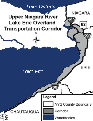
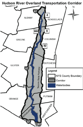
Overland transportation corridors
Three defined overland transportation corridors were designated for the purposes of allowing the transport and use of uncertified baitfish by anglers in specific areas of the state. The three overland transportation corridors are intended to primarily serve anglers fishing three major waterbodies:
- the Lake Erie-Upper Niagara River;
- the Lower Niagara River-Lake Ontario-St.
Lawrence River; and
• the Tidal Hudson River.
Uncertified baitfish are only allowed to be used on the same body of water where they were collected within these corridors.
Transportation of purchased uncertified baitfish within an Overland Transportation Corridor
Uncertified baitfish purchased from a bait dealer may be transported within a designated overland transportation corridor provided a receipt, issued by the seller and retained by the purchaser while in possession of the baitfish, contains
- the seller’s name,
- date of sale,
- the species of fish,
- the number of each species sold,
- the waterbody the baitfish must be used in,
- the overland transportation corridor the baitfish must be transported within, and
- a warning that the baitfish may only be transported within that overland transportation corridor.
Transportation of personally collected baitfish within an Overland Transportation Corridor
Personally collected baitfish taken from a waterbody within an overland transportation corridor may be transported within that corridor. These baitfish may only be used in the same waterbody they were collected in.
Designated Overland Transportation Corridors
The three overland transportation corridors are defined as follows:
1. Upper Niagara River/Lake Erie Overland Transportation Corridor shall mean the geographical area associated with the New York portion of Lake Erie and the Upper Niagara River west of and including a line starting at I-90 at the Pennsylvania border, then continuing east to its intersection with I-290, then continuing north along I-290 to its intersection with State Rte. 62, then continuing west to its intersection with I-190, then north to its intersection with the Lower Niagara River. Baitfish collected from the New York portion of the Upper Niagara River/Lake Erie waterbody may be transported within this corridor.
- Hudson River Overland Transportation Corridor shall mean the geographical area associated with the Hudson River south of the Federal Dam at Troy starting at the eastern shore of the Hudson River at the Federal Dam in Troy, continuing east on
- Glenn Ave. in Troy to its intersection
with State Rte. 4, then continuing south on State Rte. 4 to its intersection with State Rtes. 9 & 20, then continuing easterly
to its intersection with State Rte. 9, then continuing east on State Rte. 82, to its intersection with the Taconic State Parkway, then continuing south on the Taconic State Parkway to its intersection with the Sprain Brook Parkway, then continuing south on the Sprain Brook Parkway to its intersection with I-287, then continuing west on I-287 across the Mario M. Cuomo Bridge to I-87 North, then continuing north on I-87 to where State Rte. 9W crosses I-87 in Greene County, then continuing north on State Rte. 9W to where State Rte. 9W crosses I-87 in Albany County, then continuing north on I-87 to its intersection with State Rte. 7, then continuing east on State Rte. 7 to its intersection with I-787, then continuing north on I-787 to its intersection with Tibbets Ave., then continuing east on Tibbets Ave. to its intersection with Delaware Ave., then proceeding in a straight line to the west edge of the Troy Dam. Baitfish collected from the New York portion of the Tidal Hudson River waterbody may be transported within this corridor.
3. Lower Niagara River/Lake Ontario/ St. Lawrence River Overland Transportation Corridor shall mean the geographical area associated with New York portion of the Lower Niagara River, Lake Ontario, and the St. Lawrence River starting at the intersection of I-190 and the Lower Niagara River, then continuing eastward to its intersection with State Rte. 104, then continuing eastward to its intersection with State Rte. 3, then continuing east on State Rte. 3 to its intersection with State Rte. 104, then continuing eastward on State Rte. 104 to its intersection with State Rte. 11,
then continuing north on State Rte. 11 to its intersection with State Rte. 56, then continuing north along State Rte. 56 to its intersection with State Rte. 37, then continuing east along State Rte. 37 to its intersection with Racquette Point Rd., then continuing north on Racquette Point Rd. to its intersection with Ransom Rd., and then continuing west on Ransom Rd. and terminating at the St. Lawrence River. Baitfish collected from the New York portion of the Lower Niagara River/Lake Ontario/St. Lawrence River waterbody may be transported within this corridor
Waters with Specific Advice For Adirondack and Catskill waters visit www.health.ny.gov/fish Specific advice also applies to connected waters if there are no barriers to stop fish from moving upstream or downstream. This is because chemicals remain in fish when they move from one waterbody to another.