Boundaries and Waters
Reservoir Boundaries
For bag, possession and length limits
- Buchanan Reservoir in Burnet, Lampasas, Llano and San Saba counties comprises all impounded waters of the Colorado River from Lake Buchanan dam upstream to the U.S. Hwy. 190 bridge.
- Caddo Lake in Marion and Harrison counties comprises all impounded waters of Big Cypress Bayou from the Texas-Louisiana border upstream to the State Hwy. 43 bridge.
- Canyon Reservoir in Comal County comprises all impounded waters of the Guadalupe River from the Canyon dam upstream to the U.S. Hwy. 281 bridge.
- Lake Conroe in Montgomery and Walker counties comprises all impounded waters of the West Fork of the San Jacinto River from the Lake Conroe dam upstream to FM Road 1791 bridge.
- Cooper Lake (Jim L. Chapman Lake) in Delta and Hopkins counties comprises all waters within the Corps of Engineers lands on Cooper Lake upstream from State Hwy. 19/154 and downstream from FM Road 71.
- Falcon International Reservoir in Starr and Zapata counties comprises all impounded waters of the Rio Grande from the Falcon Dam upstream to the Zapata/Webb County line.
- Lake Georgetown in Williamson County comprises all impounded waters of the North Fork of the San Gabriel River from the Lake Georgetown dam upstream to U.S. Hwy. 183 bridge.
- Gibbons Creek Reservoir in Grimes County comprises all waters within the Texas Municipal Power Agency property boundaries.
- Inks Lake in Burnet and Llano counties comprises all impounded waters of the Colorado River from the Roy Inks dam (Inks Lake dam) upstream to the Lake Buchanan dam.
- Lake Limestone in Leon, Limestone and Robertson counties comprises all impounded waters of the Navasota River from the Lake Limestone dam upstream to the Fort Parker State Park Lake dam.
- Lake Livingston in Leon, Houston, Madison, Polk, San Jacinto, Trinity and Walker counties comprises all impounded waters of the Trinity River from the Lake Livingston dam upstream to the lock and dam near State Hwy. 7.
- Lake Lyndon B. Johnson in Burnet and Llano counties comprises all impounded waters of the Colorado River from the Alvin Wirtz Dam (Lake Lyndon B. Johnson dam) upstream to the Roy Inks dam (Inks Lake dam) including the Llano River upstream to the State Hwy. 16 bridge and Sandy Creek upstream to the State Hwy. 71 bridge.
- Lake Marble Falls in Burnet County comprises all impounded waters of the Colorado River from the Max Starcke dam (Lake Marble Falls dam) upstream to the Alvin Wirtz dam (Lake Lyndon B. Johnson dam).
- Lake Murvaul in Panola County comprises all impounded waters of Murvaul Creek Bayou upstream from the Lake Murvaul Dam and Murvaul Creek Bayou downstream from the dam to FM Road 1970 bridge.
- Lake O' The Pines in Camp, Marion, Morris and Upshur counties comprises all impounded waters of Big Cypress Creek from the Ferrell's Bridge Dam (Lake O' The Pines dam) upstream to U.S. Hwy. 259 bridge.
- Lake Palestine in Anderson, Cherokee, Henderson, Smith and Van Zandt counties comprises all impounded waters of the Neches River from the Blackburn Crossing dam (Lake Palestine dam) upstream to FM Road 279 bridge including Kickapoo and Flat Creeks in Henderson County.
- Lake Pat Mayse in Lamar County comprises all impounded waters of Sanders Creek from Pat Mayse Lake Dam upstream to County Road 35610.
- Purtis Creek State Park Lake in Henderson and Van Zandt counties comprises all waters within the Purtis Creek State Park boundaries.
- Lake Somerville in Burleson, Lee, Milam and Washington counties comprises all impounded waters of Yegua, East Yegua and Middle Yegua Creeks upstream from the Lake Somerville dam.
- Lake Texoma in Cooke and Grayson counties comprises all impounded waters of the Red River from the Denison Dam upstream to Sycamore Creek.
- Sam Rayburn Reservoir in Angelina, Jasper, Nacogdoches, Sabine, and San Augustine counties comprises all impounded waters of the Angelina River from the Sam Rayburn Dam upstream to the Union Pacific railroad bridge.
- Toledo Bend Reservoir in Newton, Panola, Sabine and Shelby counties comprises all impounded waters of the Sabine River from Toledo Bend Dam upstream to the Texas-Louisiana state line in Panola County.
- Lake Travis in Burnet and Travis counties comprises all impounded waters of the Colorado River from the Mansfield dam (Lake Travis dam) upstream to the Max Starcke dam (Lake Marble Falls dam) including the Pedernales River upstream to the Hammetts Crossing-Hamilton Pool Road bridge.
Freshwater/Saltwater Boundary
All public waters east and south of the following boundary are considered salt water:
- beginning at the International Toll Bridge in Brownsville, northward along U.S. Hwy. 77 to the junction of Paredes Lines Road (FM Road 1847) in Brownsville, thence
- northward along FM Road 1847 to the junction of FM Road 106 east of Rio Hondo, thence
- westward along FM Road 106 to the junction of FM Road 508 in Rio Hondo, thence
- northward along FM Road 508 to the junction of FM Road 1420, thence
- northward along FM Road 1420 to the junction of State Hwy. 186 east of Raymondville, thence
- westward along State Hwy. 186 to the junction of U.S. Hwy. 77 near Raymondville, thence
- northward along U.S. Hwy. 77 to the junction of the Aransas River south of Woodsboro, thence
- eastward along the south shore of the Aransas River to the Junction of the Aransas River Road at the Bonnie View boat ramp, thence
- northward along the Aransas River Road to the junction of FM Road 2678 to the junction of FM Road 774 in Refugio, thence
- eastward along FM Road 774 to the junction of State Hwy. 35 south of Tivoli, thence
- northward along State Hwy. 35 to the junction of State Hwy. 185 between Bloomington and Seadrift, thence
- northwestward along State Hwy. 185 to the junction of FM Road 616 in Bloomington, thence
- northeastward along FM Road 616 to the junction of State Hwy. 35 east of Blessing, thence
- southward along State Hwy. 35 to the junction of FM Road 521 north of Palacios, thence
- northeastward along FM Road 521 to the junction of State Hwy. 36 south of Brazoria, thence
- southward along State Hwy. 36 to the junction of FM Road 2004, thence
- northward along FM Road 2004 to the junction of Interstate Hwy. 45 between Dickinson and La Marque, thence
- northwestward along Interstate Hwy. 45 to the junction of Interstate Hwy. 610 in Houston, thence
- east and northward along Interstate Hwy. 610 to the junction of Interstate Hwy. 10 in Houston, thence
- eastward along Interstate Hwy. 10 to the junction of State Hwy. 73 in Winnie, thence
- eastward along State Hwy. 73 to the junction of U.S. Hwy. 287 in Port Arthur, thence
- northwestward along U.S. Hwy. 287 to the junction of Interstate Hwy. 10 in Beaumont, thence
- eastward along Interstate Hwy. 10 to the Louisiana State Line.

The following public waters are not considered salt water:
- waters of Spindletop Bayou inland from the concrete dam at Russels Landing on Spindletop Bayou in Jefferson County;
- north of the dam on Lake Anahuac in Chambers County;
- the waters of Taylor Bayou and Big Hill Bayou inland from the saltwater locks on Taylor Bayou in Jefferson County;
- Galveston County Reservoir on State Hwy. 146 and Galveston State Park Ponds #1 through #7 in Galveston County;
- Lakeview City Park Lake, West Guth Park Pond and Waldron Park Pond in Nueces County;
- Lake Burke-Crenshaw and Lake Nassau in Harris County;
- Fort Brown Resaca, Resaca de la Guerra, Resaca de la Palma, Resaca de los Cuates, Resaca de los Fresnos, Resaca Rancho Viejo and Town Resaca in Cameron County; and
- Little Chocolate Bayou Park Ponds #1 and #2 in Port Lavaca in Calhoun County.
Requirements for Federal, State & Border Waters
Requirements for Federal Waters and State Tidal Waters
Recreational anglers must have a Texas fishing license and saltwater endorsement to:
- Possess in state water any fish taken in federal waters
- Possess fish on a vessel in the tidal waters of Texas (see Fishing in Federal Waters)
Requirements for Border Waters
All fish landed in Texas must comply with Texas bag and length limits. No exceptions.
Texas-Arkansas
In Arkansas waters of the Red River, requirements of that state apply.
Texas-Oklahoma
- In Oklahoma waters of the Red River, requirements of that state apply.
- A person may fish in Texas or Oklahoma waters on Lake Texoma only with the appropriate license from Texas or Oklahoma, unless the person possesses a Lake Texoma fishing license.
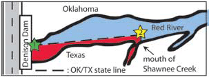
- A person must have a valid Texas fishing license to fish from the Texas bank from Denison Dam to Shawnee Creek (south of the line between border markers 1 and 2 on the map illustration). GPS coordinates are as follows: Marker 1(Lat 33.81892, Long -96.56806), Marker 2 (Lat 33.81986, Long -96.5556). An Oklahoma fishing license is required to wade-fish or fish from a boat in these waters.
- An Oklahoma resident 65 years of age or older is exempt from fishing license requirements in Texas, including on Lake Texoma.
- The upstream boundary of Lake Texoma is Sycamore Creek at Latitude 33°53.663’, Longitude -96°59.009’.
Texas-Louisiana
Residents of either state, who are properly licensed in their state (or are exempt because of age), or persons who hold valid non-resident fishing licenses issued by either state may fish in any portion of the lakes and rivers forming a common boundary between Louisiana and Texas inland from a line across Sabine Pass between Texas Point and Louisiana Point. Fish landed in Texas must adhere to the Texas bag and length limits.
Texas-Mexico
Border States Include Tamaulipas, Nuevo León, Coahuila, Chihuahua
A recreational fishing license or Permiso de Pesca Deportiva [managed by the Mexican federal agency CONAPESCA (Comisión Nacional de Acuacultura y Pesca)] is required to fish in Mexican waters. Recreational anglers can buy permits for a single day, week, month or year.
Fishing in Federal Waters
Anglers fishing more than 9 nautical miles off the coast of Texas are in federal waters and are subject to rules and regulations that may differ from those in state waters. One example is the federal requirement to use non-stainless circle hooks when fishing for reef fish. Recreational anglers must have a Texas fishing license and saltwater endorsement to possess in state water or land in Texas any fish taken in federal waters. TPWD has the authority to open and close the red snapper fishery in federal water. Anglers may not possess more than 4 red snapper while fishing. See the latest information regarding red snapper season dates. Federal commercial and recreational fishing rules are available on the Gulf of Mexico Fishery Management Council website.
The limits and restrictions in this guide apply to aquatic life caught in the public waters of Texas out to 9 nautical miles in the Gulf of Mexico, and to aquatic life caught between 9 and 200 nautical miles in the Exclusive Economic Zone (EEZ) and possessed in state waters or landed in this state. Federal law also regulates species between 9 and 200 nautical miles managed under a Federal Fishery Management Plan. See Importation of Wildlife Resources.
Fishing on state-sponsored offshore artificial reefs is subject to the same regulations as other offshore locations.
It is unlawful to posses aquatic life in Texas waters that was illegally taken in federal waters.