Several Type 3 and 4 streams have a year- round reduced daily possession limit of one (1) Rainbow Trout 20" or greater (see pp. 42-65).
Great Lakes and Great Lakes Connecting Waters - Lake Trout & Splake
The daily possession limit between the two species has been combined (see p. 21).
Lake Huron Lake Trout Management Unit MH-1
The daily possession limit for Lake Trout and Splake combined (total in any combination) has been increased from 2 to 3 in MH-1 (see p. 21).
Attention Charter Boat Captains and Inland Sportfishing Guides
Beginning on March 1, 2024, inland sportfishing guides will be required to acquire a license that is valid for 3 years. Additionally, licensed inland sportfishing guides will be required to submit monthly catch activity reports to the Michigan Department of Natural Resources. For more information visit Michigan.gov/Fishing.
Fishing License Requirements and Special Provisions
You must purchase a license if you are 17 years of age or older.
If you are under 17, you may fish without a license, but you are required to observe all fishing rules and regulations.
When fishing, you must carry your license and the identification used to purchase that license and exhibit both upon request of a Michigan Conservation Officer, a Tribal Conservation Officer or any law enforcement officer.
The Michigan Department of Natural Resources has an electronic license that allows an individual to display a copy of the fishing license using a smart phone or similar device.
Your annual fishing license is valid from March 1 of a given year through March 31 of the following year.
To purchase a fishing license you must have:
A valid Michigan Driver's License; or
A valid Michigan ID Card (issued by the Secretary of State); or
A valid driver's license from your state of residency; or A DNR Sportcard (issued by license dealers). If the information on your DNR Sportcard from a previous year is still accurate, you may continue to use it. NOTE: when purchasing a DNR Sportcard you will be asked to provide two proofs of Michigan residency.
To qualify for a resident fishing license, you must:
Be a person who resides in a settled or permanent home or domicile within the boundaries of this state with the intention of remaining in this state, or
Be a full-time student at a Michigan college or university, and reside in Michigan, or
Serve full-time in the U.S. Military and be either officially stationed in Michigan or maintain residency in Michigan.
The ownership of land in Michigan by itself is not qualification for a resident license.
Other special provisions:
U.S. Military Personnel: Fishing license fees are waived for full-time, federal, active-duty U.S. military personnel who have maintained resident status.The individual must present military ID, leave papers, duty papers, military orders or other evidence verifying that he/she is an active-duty member of the military, along with a valid Michigan driver's license or voter registration card. This license, available at DNR Customer Service Centers and at license retail outlets statewide, is valid for the license year. Military members receiving a free license must present the license, along with proof of military status, if requested
by a Conservation Officer. NOTE: nonresident,
active-duty military personnel officially stationed in Michigan qualify for Michigan resident rates.
Michigan Veterans with Disabilities: A resident veteran with a disability is eligible to obtain a fishing license, that does not require a separateapplication, free of charge if one of the following conditions is met: the person has been determined by the U.S. Department of Veteran Affairs to bepermanently and totally disabled as a result of military service and entitled to veterans' benefits at the 100% rate, for a disability other than blindness, or the person has been rated by the U.S. Department of Veteran Affairs as individually unemployable.
Residents who are blind: A resident who is declared legally blind is eligible to purchase the senior fishing license.
Persons with developmental disabilities or residents of a home for the aged (licensed under the Public Health Code): A developmentally disabled individual or a resident of a home for the aged licensed under the Public Health Code may obtain a permit from the DNR to fish without a license if the developmentally disabled individual or the resident of the licensed home for the aged is a member of a group accompanied by 1 or more adults who hold a valid license to fish. Permits are available at DNR Customer Service Centers.
Description of Inland Waters
Inland waters are all waters within the jurisdiction of the state except the Great Lakes, and the bays and connecting waters. The connecting waters betweenLake Superior and Lake Huron include that portion of the St. Marys River located within this state. The connecting waters of Lake Huron and Lake Erie include the St. Clair River (begins at the Fort Gratiot Light), Lake St. Clair and the Detroit River (beginning at the imaginary line extending due south ofthe Windmill Point Light, Wayne County, and ending at the imaginary east-west line drawn through the most southerly point of Celeron Island). Inlandwaters include all inland lakes, streams and tributaries to the Great Lakes.
Closed Seasons (Spawning Closures)
Michigan prohibits fishing for various species at certain times of the year. These seasonal closures generally coincide with spawning periods and are often referred to as spawning closures. Many anglers and managers tend to think of these regulations as providing specific protection to spawning fish,and the timing and length of closed seasons are generally related to the timing and duration of spawning seasons. These closures are indicated by lake or stream in the county listing. Lakes and streams are closed to all fishing during the period listed.
Native American Fishing on Inland Waters
Federal treaties exist between the United States government and tribes residing in Michigan. Although the entire State of Michigan is covered by treaties, only two treaty areas are currently subject to fishing b y t ribal g overnments. T he Treaty of Washington, signed in 1836, covers the eastern Upper Peninsula and the northern Lower Peninsula of Michigan. The Treaty of La Pointe, signed in 1842, covers the western Upper Peninsula and areas of northern Wisconsin.
Seasons and possession limits for tribal members may differ somewhat from state regulations. In addition, under a permit system, tribal members mayuse spears and may place impoundment nets on designated public waters. The use of gill nets is prohibited in inland waters. If you encounter these activities, do not disrupt the fishers or interfere with their nets. For more information please visit Michigan.gov/TribalCoordination.
DID YOU KNOW:
Violators of fishing rules & regulations can face fines, jail time, loss of fishing equipment and/or revocation of their fishing license?
Species
Fine
Jail
Revocation of License / Permit
Violation under section 41105
Fish - 1st Offense
Up to $100 (1st offense); OR
Up to 60 days (1st offense)
Optional
Violation under section 41105
Fish - 2nd or Subsequent Offense
$50 - $250; OR
20-90 days
Optional
Violation under section 48702a*
Fish - 1st Offense
$500 - $1,000 (plus costs of prosecution)
Up to 93 days
Required
Violation under section 48702a*
Fish - 2nd or Subsequent Offense
$1,000 - $2,500 (plus costs of prosecution)
Up to 1 year
Required
*NOTE: Violations under section 48702a could lead to a fine, jail or both.
DEFINITIONS & TERMS
Artificial Flies: Known as wet and dry flies, streamers, or nymphs, is defined as a single-pointed hook, or not more than two single-pointed hooks connected in-line (the second hook commonly known as a stinger hook), crafted with natural, artificial and/ or synthetic materials attached to the hook with thread. An artificial fly may not include a spinner, spoon, scoop, lip or any other fishing lure or bait attached. Material of any type cannot be attached above the eye of the hook. The fly or leader may be weighted, but no weight shall be attached to the terminal tackle in a manner that allows the weight to be suspended from or below the hook. Single- pointed hooks are restricted to measuring 1/2-inch or less from point to shank.
Artificial Lure: A manmade lure manufactured to imitate natural bait. Artificial lures include spoons, spinners, flies and plugs made of metal, plastic, wood and other non-edible materials. They also include plastic products made to resemble worms, eggs, fish and other aquatic organisms. NOTE: On the following waters from Aug. 1 - Nov. 15, terminal fishing gear is restricted to single-pointed hooks or jigs, measuring 1/2-inch or less from point to shank or treble hooks 3/8-inch or less from point to shank ONLY when attached to a body bait, plug, spinner or spoon. An artificial lure is not a device primarily constructed of lead: all waters of the Betsie R. (Benzie and Manistee Cos.), all waters of Bear Cr. (Manistee Co.), the Manistee R. from Tippy Dam downstream to Railroad Bridge below M-55 (T22N, R16W, S31; Manistee Co.), Big Sable R. from mouth upstream to Hamlin Lake Dam (Mason Co.), all waters of the Pere Marquette R. (Lake, Mason, Newaygo and Oceana Cos.), all waters of the Little Manistee R. (Lake, Manistee and Mason Cos.), White R. from mouth upstream to Hesperia Dam (Muskegon and Oceana Cos.), all waters of N. Br. White R. (Muskegon and Oceana Cos.) Muskegon R. upstream to Croton Dam (Muskegon and Newayago Cos.), and all waters of the N. Br. Pentwater R.(Mason and Oceana Cos.), S. Br. Pentwater R. upstream to Hart Dam (Mason and Oceana Cos.).
Cast Net: A net without walls or sides that is thrown to take minnows, alewife, smelt and shad in the Great Lakes and Connecting Waters. There is no restriction onthe size of cast nets allowed.
Catch-and-Immediate-Release (CIR): The act of returning fish immediately to the water without injury and without holding in a livewell or similar device.Anglers may continue to fish CIR given they have reached their daily possession limit for a given species.
Chumming: Luring or attracting or attempting to lure or attract fish by scattering organic material into the water. Material commonly used as chumincludes fish eggs, corn, rice, noodles, oatmeal and maggots.
Cisco: Also known as lake herring.
Competitive Fishing Event: Any organized competition among anglers involving prize distribution or the declaration of a winner that is not defined as a fishing tournament with specific rules applying to that particular event.
Daily Possession Limit: The total number of fish, amphibians or reptiles that may be caught and retained in one calendar day and includes those that areconsumed or given away. See also Possession Limit.
Dates: Whenever dates are listed they are considered inclusive.
Designated Trout Lake: Any lake so designated by law , that contains a significant population of trout or salmon. All Type A and Type D lakes are designated trout lakes.
Designated Trout Stream: Any stream, so designated by law, that contains a significant population of trout or salmon. All of the following: Type 1, Type 2, Gear Restricted Streams, and Brook Trout Research Areas, and most Type 3 and Type 4 waters are designated trout streams.
Dip Net: A square net constructed from a piece of webbing of heavy twine, hung on heavy cord or frame so as to be without sides or walls, and suspended from the corners and attached in such a manner that when the net is lifted no part is more than 4 feet below the plane formed by the imaginary lines connecting the corners from which the net is suspended. As used in fishing, it shall be lowered and raised vertically as nearly as possible (also referred to as adrop net or umbrella net).
Dropper Line: A line in addition to the main fishing line that contains a hook. Dropper lines are usually attached to the main line.
Drop-Shotting: Using a weight suspended below a single-pointed hook that is tied directly to the main fishing line.
Drowned River Mouth Lakes (Type F): A lake- like area of a river where it enters the Great Lakes. Considered inland waters and are listed below.
Eviscerated: To have internal organs removed from the body cavity or have gills severed to ensure the organism is dead.
Fishing License: A required item for any resident or nonresident angler age 17 or older targeting fish, amphibians, crustaceans or reptiles in Michigan. Annual licenses are valid from March 1 of a given year through March 31 of the following year.
Fishing Season: The period of time a body of water is open to fishing. It is unlawful to fish in any body of water outside of the fishing season.
Fishing Tournament: An organized, competitive fishing event among anglers, or teams of anglers, with specific rules applying to that particular event. See also FishingTournamentInformation.
Fishing Tournament Information System: An electronic system fishing tournament directors use to register their fishing tournaments.
Great Lakes Connecting Waters (Connecting Waters): Specific bodies of water in Michigan that connect the Great Lakes. The designated connecting waters are L. St. Clair, St. Marys R., St. Clair R. (begins at the Fort Gratiot Light) and the Detroit R.(begins at the imaginary east/west line extending due south of the Windmill Point Light, Wayne Co., andending at the imaginary east/west line drawn through the most southernly point of Celeron Isl.). NOTE: Portage/Torch Lakes (Houghton Co.) are not designated as Great Lakes Connecting Waters.
Hand Net and Landing Net: A mesh bag of webbing or wire, suspended from a circular, oval or rectangular frame attached to a handle. These are the most common fishing nets used in Michigan.
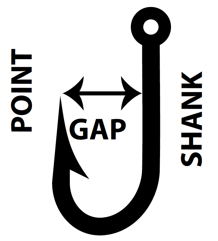
Hook & Hook Gap Measurement: A single, double or treble pointed hook. All hooks - single, double or treble pointed and attached to a manufactured artificial lure shall be counted as 1 hook. Please refer to diagram to the right. The same method is used for single and multi-pointed hooks.
Inland Trout & Salmon Regulation Maps: Maps are available online to assist anglers in identifying which trout and salmon regulations apply on specific stream reaches and inland lakes categorized by Type. The maps are posted at Michigan.gov/Fishing.
Inland Waters: All waters in Michigan EXCEPT the Great Lakes and the Great Lakes ConnectingWaters.
Minnows: Chubs, shiners, dace, stonerollers, sculpins (muddlers), mudminnows, and suckers of a size used for bait in hook-and-line fishing.
MutilatedFish: A fish that is unidentifiable or cannot be measured.
Possession Limit: In addition to 1 day’s daily possession limit of fish, a person may possess an additional 2 daily possession limits of fish taken during previous fishing days provided the additional limits of fish are processed (canned, cured by smoking or drying, or frozen). This provision does not apply to lake sturgeon or muskellunge. Anglers who have not attained the age of 17 are entitled to the possession limit even though they do not have a fishing license. A person fishing waters bordered by other states or provinces AND possessing multiple fishing licenses may possess the limit allowed for ONLY ONE license while in transit. When fishing in Michigan waters, Michigan possession and size limits must be followed.
Possession Season: The portion of the fishing season during which it is legal to harvest fish.
Protected Slot Limit: Prohibits the possession or harvest of fish that fall within a protected minimum and maximum size interval.
River vs. Stream: The same regulations apply whether a body of water is designated as a river or a stream. They are regulated the same in Michigan.
Round Whitefish: Also known as Menominee.
Snag or Snagging: Taking or attempting to take a fish in a manner or methods where the fish does not take, or have the chance to take, the hook voluntarily in its mouth. Snagging shall include, but not be limited to, fishing by manipulating a hook or hooks and other tackle or lures, whether baited or not, in such a manner as to pierce orhook a fish in any part of the body, circumventing the voluntary action of the fish to take the bait or lure in the mouth.
Tournament Registration: Following the appropriate process to register bass and walleye tournaments or muskellunge competitive fishing events with the department.
Trapping: Catching or taking fish by use of a device, such as a cage or net, designed to capture a fish or animal.
Type: Refers to the regulation category that an inland stream or inland lake is classified as. Inland Trout & Salmon Lake Regulations are categorized as Types A - F.Inland Trout & Salmon Regulations are categorized as Types 1 - 4, Brook Trout Restoration Areas (BTRA) and Gear Restricted Streams (GR).
Weir: A fence or structure set in water to block or retain fish.
Youth Fishing License: a voluntary fishing license for young anglers under 16 years of age. All youth fishing licenses sold result in a federal match (of $9 per license)garnering additional funding to be used for sport fishing programs in Michigan.
LAWFUL FISHING METHODS
Artificial Lights: Artificial lights may be used for fishing; however, artificial lights may not be used to spear frogs.
Bait: Any fish and frogs may be used as bait when legally taken and possessed, EXCEPT lampreys, live carp, goldfish or live gobies. Wigglers (mayfly nymphs) and other aquatic nymphs and larvae also may be used for bait, but may not be taken from any trout stream except for personal use on the same stream. Crayfish may be taken for bait and personal use (see below). See exceptions on the Michigan Wisconsin Boundary Waters. To help reduce the spread of invasive species, anglers are reminded to properly dispose of all bait containers including worms and soil, crayfish and minnows in a trash receptacle. NOTE: Bait fish may only be used in the waters where collected.
Bow Fishing: Bow and arrow and crossbow may be used on certain waters for certain species. See Table 3 Bow and Spear Fishing Regulations.
Crayfish: Native crayfish may be harvested in all waters as long as the water body is open to fishing. In designated trout waters, crayfish may only be taken during the fishing season for trout. Anglers may use traps, nets, hook-and-line or hands to harvest crayfish. All crayfish traps must bear the owners nameand address. There is no minimum size limit or possession limit. Crayfish species not native to Michigan waters, including (but not limited to) red swamp crayfish (Procambarus clarkii) may not be used for bait, whether alive or dead, on any waters of this state whether those waters are public or private. However,rusty crayfish may be harvested live for personal consumption, or harvested and used as bait if they are dead. On Michigan-Wisconsin boundary waters, crayfishmay not be possessed or used for bait, whether alive or dead.
Dip Nets: Dip nets may be used for bowfin, carp, longnose gar, smelt and suckers in waters that are not designated trout streams. A permit is required if equipment is to be left overnight. See Table 5 General Netting Regulations.
Drop-Shotting: The practice of having a weight suspended below a single-pointed hook that is tied directly to the main fishing line is lawful on inland lakes,drowned river mouths, Great Lakes and Great Lakes Connecting Waters only. This gear may not be used on rivers or streams.
Gaffs: Gaffs may be used to help land lawfully hooked fish on all waters EXCEPT on a designated trout stream. Never use a gaff on fish that are not legal to harvest or fish you plan to release.
Hand Nets: Hand nets of any handle length may be used to help land lawfully hooked fish. Hand nets may also be used to take bowfin, carp, longnose gar,smelt and suckers. See Table 5 General Netting Regulations.
Hook-and-Line Fishing: Fish not hooked in the mouth must be returned to the water immediately. No more than 3 lines per person (including tip-ups) ormore than 6 hooks or lures may be used. All hooks attached to an artificial bait or “night crawler harness” are counted as 1 hook (EXCEPTION: for crappie/perch rigs and umbrella rigs each hook is counted separately as part of total allowed). Hooks must be baited or attached to an artificial bait. All tip-ups and other similar devices must be marked with the name and address of the owner in legible English, either directly on the object or securely fastened to it bya plate or tag. All lines must be under immediate control. Hook and size regulations exist on certain streams (see Exceptions to General Regulations by County).
Hoop Nets: May be used for burbot only on certain waters Dec. 15 – last day of Feb. A permit is required through a local DNR office. See Table 5 General Netting Regulations. Hoop nets shall be no larger than 36" in diameter, and no longer than 7' in length.
Minnowsfor Personal Use: Minnows for personal use may only be taken with hook-and-line, seines, dip nets, hand nets and traps with a valid fishing licenseandmayonlybeusedinthewaterswheretheyare collected. In designated trout lakes and streams, minnows may only be taken during the open season for trout by hook-and-line or minnow traps. NOTE: Minnows may not be taken from LEELANAU CO.: Hatlem’s Cr. Gear restrictions are as follows: seines must not be over 12 feet by 4 feet; hand nets not over 8 square feet and without sides or walls; and minnow traps not over 24" long and need to have a funnel opening no larger than 1 1/2". Minnow traps must bear the owner's name and address. Cast nets may be used to take minnows, alewife, smelt and shad in the Great Lakes, L. St. Clair, and the Detroit R., St. Clair R., and St. Mary’s R.
Spearing: Hand, rubber or spring-propelled spears may be used for certain species. See Table 3 Bow and Spear Fishing Regulations.
UNLAWFUL ACTIVITIES
It Is Unlawful To:
Chum with organic material in all stream types.
Possess or transport any live transgenic (genetically engineered) organism or any live specimen of the following non-native fish, crayfish, o r f reshwater m ollusk: b ighead c arp, black carp, silver carp, grass carp (white amur), members of the snakehead family (Channidae), Wels catfish,bitterling, stone moroko, zander, Ide, Japanese weatherfish, rudd, tench, Eurasian ruffe, tubenose goby, round goby, red swamp crayfish, yabby crayfish,rusty crayfish (except for personal consumption as noted), killer shrimp, zebra mussel, golden mussel or quagga mussel. To do so may result in civilfines up to $10,000.
Use red swamp crayfish for bait, whether alive or dead, on any waters of this state.
Import, plant or transplant live fish including viable eggs of any fish without permit.
Buy or sell fish or parts of fish, reptiles, amphibians or crayfish taken under a sport fishing license.
Take fish for the sole purpose of removing the eggs.
Harvest, attempt to harvest, or possess any threatened or endangered species except as authorized by the DNR. For more information, look at Michigan's Rare Plants & Animals list at mnfi.anr.msu.edu/species.
Harvest or attempt to harvest freshwater mussels (clams or bivalves) whether living or dead, including the shell or parts thereof, from any waters of thestate.
EXCEPTION: A special cultural or collectors permit may be obtained from the DNR for the taking of freshwater mussels.
Use multi-pointed hooks exceeding 3⁄8" between point and shank and/or single-pointed hooks exceeding ½" between point and shank on all streams (including tributaries to the Great Lakes) from Aug. 1 - May 31.
Use lures exceeding one ounce on all streams from Aug. 1 to May 31 except when fishing in the Detroit R., St. Clair R., and St. Marys R.
Possess or sell a multi-pointed hook with a weight permanently attached.
Take or possess on any waters over which this state has jurisdiction any fish that is so mutilated
that the identification or measurement of that fish is impossible.
Possess more than the Michigan daily possession limit when fishing in Michigan waters, even if holding licenses from more than one state or province.
Commercially take, possess or sell rusty crayfish in Michigan.
Commercially take amphibians or reptiles in Michigan.
Disturb or remove reptile eggs from the wild without a permit.
Fish for any species or possess fishing devices along a stream or lake closed to fishing.
Fish with your hands, firearms, explosives, setlines, poisons or methods other than lawful fishing methods.
Fish anywhere in a fish ladder or within 100 feet of a lamprey control weir.
Use a net to take a fish within 100 feet of a dam (landing nets are allowed to secure a legally hooked fish).
Use a seine for any species other than minnows.
Use cast nets in any inland water.
Shoot reptiles or amphibians with a firearm (including spring, air or gas propelled), bow and arrow or crossbow.
Have a weight rigidly attached to a multi-point hook, or suspended from a multi-point hook.
Fish on a river or stream (see NOTE 2) using a weight suspended below any hook, unless the hook is on a dropper line (a leader) that is at least 3"long.
Fish on a drowned river mouth (Type F) using a weight suspended below any multi-pointed hook or single-pointed hooks exceeding a 1/2" between point and shank.
Deposit litter, fish offal or any foreign matter in any waters of the state or any lands, private or public.
Takeor attempt to take fish outside of the open season for that species (unless there is a specified CIR season for that species).
Commercially harvest wigglers from any state waters from June 1 – Sep. 1.
Snag a fish, attempt to snag a fish, or possess a fish that was snagged.
Possess a Prohibited or Restricted Species, the possession of a fish species listed as prohibited or restricted per MCL 324.41301 or Invasive Species Order Amendment No. 1 of 2020 is prohibited unless it is eviscerated or adheres to criteria described within MCL 324.41301(2).
GENERAL FISHING REGULATIONS
This table provides general statewide regulations for the species listed. However, there are many waters in the state that have fishing regulations which differ from those inthis table. For instance, it is unlawful to possess fishing gear or fish for suckers on designated trout waters during the closed fishing season. Please refer to theMichigan-Wisconsin Boundary Waters, Sylvania Wilderness Area, Exceptions to General Regulations by County, and Inland Trout &Salmon Regulations for exceptions. Table notes are found below. ATTENTION ANGLERS: There are regulations requiring all bass and walleye tournaments and muskellunge contests be registered.
Table 1: General Fishing Regulations
Species (NOTE 1)
Minimum Size (inches)
Daily Possession Limit
Possession Seasons
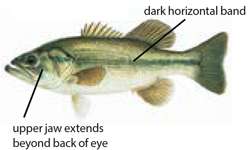
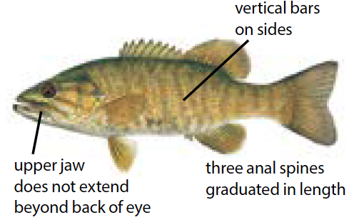
Largemouth Bass Smallmouth Bass (NOTE 2)
14"
5 in any combination
3rd. Sat. in June - Dec. 31: L. St. Clair, St.
Clair R., Detroit R. (See NOTE 2)
Sat. before Memorial Day - Dec. 31: All other waters including Gr. Lakes (except those listed in NOTE 2)
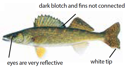
Walleye
(NOTE 3)
15"
5
May 15 – March 15: Upper Peninsula Gr. Lakes and inland waters, and St. Marys R. Last Sat. in April – March 15: Lower Peninsula inland waters
Open All Year: Lower Peninsula Gr. Lakes, L.
St. Clair, St. Clair R. and Detroit R.
Northern Pike
(NOTE 4)
24"
2
Flathead Catfish
15"
5
Open All Year
Channel Catfish
12"
10
Muskellunge (including Tiger Muskellunge) (See NOTE 4)
42" (SeeNOTE
4 for exceptions)
Only 1 per angler
per license year (Mandatory Registration)
1st Sat. in June – March 15: All Gr. Lakes and inland waters and St. Marys R.
1st Sat. in June – Dec. 31: L. St. Clair, St.
Clair R. and Detroit R.
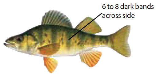
Yellow Perch
(NOTE 5)
No size limit
25
Open All Year
Sunfishes
(NOTE 6)
25 in any
combination of the
listed species
White Bass
25 on Gr. Lakes,
L. St. Clair, St. Marys R., St. Clair
R., and Detroit R.
10 on inland waters
Cisco, Lake Whitefish, Round Whitefish
(NOTE 7)
10 in any
combination on Gr. Lakes, Connecting
Waters and Type F lakes, 5 in any
combination on other inland waters
Lake Sturgeon
Please see Table 2, p. 15 for Lake Sturgeon Regulations
Smelt
No size limit
2 gallons
Open All Year
(See p. 23, Table 5 for Netting Regulations)
All others
(NOTE 8)
No size limit
No possession limit
Open All Year
NOTES for Table 1
NOTE 1 - All Warmwater Fish:
Warmwater fish include all species listed in this table. Regulations for trout and salmon on inland waters are provided on below along with Great Lakes trout and salmon.
NOTE 2 - Largemouth & Smallmouth Bass:
Catch-and-Immediate-Release (CIR) seasons: CIR fishing for bass is allowed all year on all waters, unless otherwise closed to fishing. All bass caught must be immediately returned to the water.
On L. Michigan, within one-half mile of the following islands of the Beaver Island Archipelago: Beaver, Garden, High and Hog, (Charlevoix Co.) the possession season is July 1 - Dec. 31 and open to bass CIR all year.
NOTE 3 - Walleye
L. Huron waters of MH-4 (see p. 20) including Saginaw Bay and lower Saginaw R. including tributaries (Bay and Saginaw Counties) from the mouth of the river, upstream to the West Center Street (Douglas G. Schenk) Bridge. The daily possession limit for walleye is 8 with a 13" minimum size limit and open all year. Any changes will be announced online at Michigan.gov/fishingand in a prerecorded message at 888-367-7060.
L. Erie, Detroit R., L. St. Clair and St. Clair R.: The daily possession limit is 6 walleye through April 30, 2024. The daily possession limit for walleye will be set on May 1, 2024. The daily possession limit will be announced on the DNR website (Michigan. gov/Fishing) and in a prerecorded message at 888-367-7060. Minimum size limit for walleye: L. Erie, Detroit R. L. St. Clair and St. Clair R. - 15".
L. Michigan waters of Little Bay de Noc (Delta Co.): No more than 1 walleye over 23" may be possessed in daily limit north of a line drawn from Peninsula Point Lighthouse to the mouth of the Bark R.
L. Michigan waters of Green Bay: from the mouth of the Menominee R. northward to latitude/ longitude (45.5505, -87.2637) located approximately 6 miles north of the Cedar R. from March 2 - Fri. before 1st Sat. in May the daily possession limit is 1 walleye and from the 1st Sat. in May - March 1 the daily possession limit is 5 walleye.
Cheboygan R. from the south end of the outermost breakwall at Mullett L. downstream to Cheboygan Dam, and Black R. from Alverno Dam downstream to its confluence with the Cheboygan R.: the possession season for walleye shall be May 15 - March 15.
Ontonagon R. (Ontonagon Co.): No more than 1 walleye over 23" may be possessed in daily possession limit.
Portage and Torch L. systems (Houghton Co.): No more than 1 walleye over 23" may be possessed in daily possession limit.
Muskellunge harvest is limited to only 1 muskellunge per angler per year (April 1 - March 31).
Catch-and-Immediate-Release (CIR) seasons: CIR fishing for muskellunge is allowed all year on all waters, unless otherwise closed to fishing. All muskellunge caught must be immediately returned to the water (see Definitions & Terms) .
Special Muskellunge Regulations:
50" Minimum Size Limit Waters:
Antrim: L. Bellaire (including all tribs upstream to Bellaire Dam), Clam L. (including all tribs), Torch L. (including all tribs); Antrim & Grand Traverse: Elk L. (above Elk Rapids Dam, including all tribs); Antrim, Grand Traverse & Kalkaska: L. Skegemog (including all tribs); Barry: Thornapple L. (from McKeown Rd. to Barger Rd.); Iron: Chicagon L. (including all tribs).
46" Minimum Size Limit Waters:
Antrim: Beals L. (including all tribs), Benway L. (including all tribs), Ellsworth L. (including all tribs), Hanley L. (including all tribs), Scotts L. (including all tribs), Wilson L. (including all their tribs), Intermediate L. (from Bellaire Dam upstream, including all tribs); Antrim & Charlevoix: Saint Clair L. (including all tribs), Sixmile L. (including all tribs); Barry: Gun L. ; Cheboygan & Presque Isle: Black L. (including all tribs); Cheboygan: Black R. (including all tribs upstream to Kleber Dam), Mullett L., Indian R., Burt L., Cheboygan R.; Cheboygan & Emmet: Crooked R. (downstream from Crooked Lake confuence); Chippewa: St. Marys R. (from compensating gates downstream to DeTour/ Drummond Island Ferry Docks); Kent: Grand R. (downstream from Sixth Street Dam);Murray L.; Ottawa: L. Macatawa, Grand R. (downstream from Sixth Street Dam); Muskegon: Mona L.
38" Minimum Size Limit Waters:
Luce: Tahquamenon R. and tribs (upstream from Upper Falls); Van Buren: Round L.; Hillsdale: L. Diane.
Special Muskellunge & Northern Pike Regulations:
Lakes with Muskellunge & Northern Pike possession seasons from the first Sat. in June - Nov. 30: Barry: Thornapple L. (from McKeown Rd. to Barger Rd.) Lenawee: L. Hudson.
Special Northern Pike Regulations:
Waters with 24” – 34” protected slot limit on Northern Pike and daily possession limit of 2 Northern Pike: Alger: Grand Sable L. Allegan: Pine Cr. Flooding Cass: Magician L. Kalamazoo: Long L. (T3S, R10W, S17/18/19/30) Kent: Bass L. (T10N, R9W, S12/13/14), and Wabasis L. Luce: Blind Sucker Flooding and Bodi L. Montcalm: Townline and Sand L. Van Buren: Magician L.
Waters where up to 5 Northern Pike of any size may be taken with only one 24" or greater allowed in the daily possession limit: Alcona: Badger L. andMcCollum L. Alger: Echo, Nawakwa, Trout and 16 Mile Lks and Au Train Basin (Forest Lake). Antrim: Beals, Benway, Ellsworth, Hanley, Scotts, Six Mile, St. Clair, and Wilson Lks. Baraga: Vermillac (Worm) L. Benzie: Long L. Charlevoix: Deer, Fox, Geneserath, Six Mile, and St. Clair and Susan Lks. Cheboygan: Black L. and tributaries, Black R. from Alverno Dam upstream, Black R. (upstream of Tower Dam includes Tower Pond and tributaries), Paradise (Carp), Silver and Wildwood Lks. Chippewa: Frenchman and Trout (Carp) Lks. Clare: Eight Point L., Little Long L., Long L. and L. Thirteen Crawford: Big Creek Imp., River and PickerelLks. Delta: Carr, Chicago, Hamilton (McDonald), Lyman and Round (T43N, R20W, S1) Lks. and Escanaba R. (upstream from first dam at US-2) Dickinson: Hamilton L., L. Louise, L. Mary, Norway, Rock, and Sawyer L. Emmet: Crooked L., French Farm and O’Neal L. Floodings, Paradise (Carp) L. and Pickerel L. Gladwin: L. Lancelot, L. Lancer and Wiggins L. Gogebic: African (Big and Little), Chaney, Cisco, Clearwater, East Bay, Fishhawk, Indian, L. Gogebic, Lindsley, Morley, Poor, Record, Sunday L. and Thousand Island Lks. Grand Traverse: Boardman L. and L. Dubonnet. Houghton: Prickett Imp. and Rice L. Ionia: Long L., Iosco: Chain Lks. Iron: Bass L., Bone, Brule, Buck, Dawson, Indian, Iron, L. Mary, Paint L., Perch L. Railroad, Runkle, Shank L., Sunset and Winslow Lks., Paint R. Pond (downstream of Horserace Rapids and upstream of Frog Island), Hemlock Falls and Michigamme Reservoir, Michigamme Falls and Peavy Reservoir, L. St. Kathryn, Deer R., Net R., and Net R. Wide Waters. Kent: Scram L. Keweenaw: Schlatter L. Leelanau: Florence L. (S. Manitou Is.). Luce: East L., Kaks L. and Muskallonge L. Mackinac: East, Millecoquins and South Manistique Lks. Manistee: Bar and Chief Lks. Marquette: Bass (East), Cedar, Engman, Shag (Big) and Witch Lks., Dead R. Storage Basin, Middle Br. Escanaba R., Big and Cataract Reservoirs) Mason: Hackert (Crystal) L. Mecosta: Canadian Lks. (in T14N, R8W, S20,29,30; north of Pierce Rd. and south of Buchanan Rd. in S19), Haymarsh and Horsehead Lks. Menominee: Bass L., L. Ann, Shakey Lakes Chain (Baker, Beecher, East, Long, Resort and Spring Lks.), Westman Imp. Missaukee: Missaukee L. Montcalm: Crystal L. and Indian L. Montmorency: Robarge L., East and West Town Corner and Pug Lks., North and South Tomahawk Lks., Black R. and tributaries. Muskegon:Big Blue L. Newaygo: Bills L., Diamond, Emerald, Kimball, Nichols, Pickerel, Ryerson (Long) and Sylvan Lks. Oceana: Round (Wykof) L. Ogemaw: East Twin Lake, L. Ogemaw and Sage L. Osceola: McCoy L., L. Miramichi, Diamond, Rose and Wells Lks. Oscoda: McCollum L. and Pickerel L. Ontonagon: L. Gogebic. Otsego: Black R. and tributaries. Presque Isle: Black L., Francis and Orchard Lks., Ocqueoc R. and tributaries, Ocqueoc Watershed Lakes (Ann, Bullhead, Ella, Emma, Ferdelman, Gorman, Horseshoe, Lost, Louise, Lower and Upper Barnhart, May, McIntosh, Moore, Mud and Nettie, andOcqueoc Lks.), Black R. and tributaries and Tomahawk Flooding. Roscommon: L. St. Helen, Cut R. (from the river mouth at Houghton L. upstream to CO 100 just downstream of Higgins L.), L. James, Houghton L., Backus Cr. from the stream mouth upstream, including all tributaries, Little Mud L. Flooding, Backus Cr. Flooding, and Backus L. Flooding. Schoolcraft: Boot, Colwell L., Crooked, Gulliver L., Kennedy, MacDonald L., Stanley and Thunder Lks., Worchester (Wolf) L. Seney National Wildlife Refuge Pools: contact Refuge office (906- 586-9851). Wexford: Pleasant L. and Stone Ledge L.
Waters where up to 5 Northern Pike 24" or greater allowed in the daily possession limit: Lake St. Clair, St. Clair R., and Detroit R.
NOTE 5 - Yellow Perch:
L. Erie: The daily possession limit for yellow perch is 50.
L. Gogebic (Gogebic and Ontonagon Cos.): The daily possession limit for yellow perch is 25 with no more than 5 yellow perch 12" or greater.
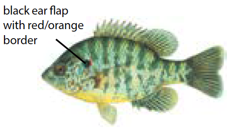
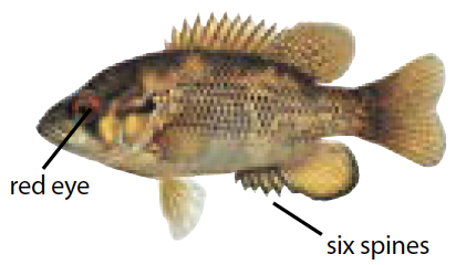
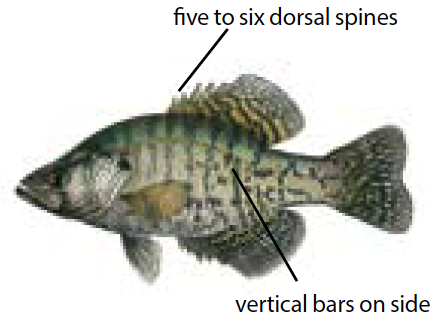
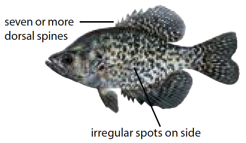
NOTE 6 - Sunfishes:
Includes: black and white crappies, bluegill, green and hybrid sunfish, longear, pumpkinseed,redear, rock bass and warmouth.
NOTE 7 - Round Whitefish:
In Lake Superior the daily possession limit shall include up to an additional ten (10) roundwhitefish.
NOTE 8 - Other Species:
Those species not listed above and not considered trout or salmon or threatened and endangered species which are protected from harvest.
LAKE STURGEON REGULATIONS
Lake sturgeon harvest is limited to only 1 lake sturgeon per angler per year (April 1 - March 31). Harvest of lake sturgeon is limited to thewaters of the state listed in the table below. Spearing for lake sturgeon is prohibited, except in Black Lake (Cheboygan & Presque Isle Cos.), duringa special winter season; pre-registration is required. For more information, visit Michigan.gov/Sturgeon.
Mandatory Reporting Information for Harvesting a Lake Sturgeon
An angler who harvests a lake sturgeon is required to report the harvest within 24 hours. Anglers can report their harvest online (Michigan.gov/RegisterFish), by calling 888-636-7778, or in person at any DNR Customer Service Center during normal state business hours with advanced notice of arrival. EXCEPTION: Lake sturgeon harvested from Black Lake (Cheboygan & Presque Isle Cos.) must be immediately registered on-site with DNR personnel.
Table 2: Lake Sturgeon
Hook & Line Fishing Only (except as indicated above)
Waters
Seasons
Regulations and Size Restrictions
Detroit River
Fishing Season:
July 16 - March 15
All lake sturgeon must be released immediately.
Lake St. Clair and St. Clair R.
Fishing Season: July 16 – March 15 Possession Season: July 16 – Sep. 30
Between 42" - 50". Lake sturgeon less than 42" and greater than 50" must be released immediately.
Otsego Lake (Otsego Co.)
Fishing and Possession Season:
July 16 – March 15
50" minimum size limit. Lake sturgeon less than 50" must be released immediately.
All MI-WI Boundary Waters
(see pp. 24-25 for more details)
Fishing and Possession Season:
1st Sat. in Sep. – Sep. 30
60" minimum size limit. Lake sturgeon less than 60" must be released immediately.
Black Lake (Cheboygan & Presque Isle Cos.)
Fishing and Possession Season:
1st Sat. in Feb. through the following Wed. or until the quota is reached (whichever comes first)
No size limit. All harvested lake sturgeon must be reported immediately to DNR on site. Contact DNR Gaylord office (989) 732-3541 for details.
St. Marys River (Chippewa Co.)
From the Soo Locks/Compensating Works downstream to the DeTour Village and Drummond Island ferry terminals to the south, and from Hay Point to Cherry Island then north to the international boundary for the northeast.
Fishing Season:
July 16 - March 15
All lake sturgeon must be released immediately.
Portage and Torch Lakes
(Houghton Co.)
This includes Portage River, Portage Canal and north and south entry.
Fishing Season:
July 16 - March 15
All lake sturgeon must be released immediately.
Ontonagon River (Ontonagon Co.) from Lake Superior up to the Victoria Dam Road
Fishing Season:
July 16 - March 15
All lake sturgeon must be released immediately.
All Other Waters
NO FISHING SEASON
It is unlawful to fish for lake sturgeon, except in the waters listed above.
Waters
Seasons
Regulations and Size Restrictions
Detroit River
Fishing Season:
July 16 - March 15
All lake sturgeon must be released immediately.
Lake St. Clair and St. Clair R.
Fishing Season: July 16 – March 15 Possession Season: July 16 – Sep. 30
Between 42" - 50". Lake sturgeon less than 42" and greater than 50" must be released immediately.
Otsego Lake (Otsego Co.)
Fishing and Possession Season:
July 16 – March 15
50" minimum size limit. Lake sturgeon less than 50" must be released immediately.
All MI-WI Boundary Waters
(see pp. 24-25 for more details)
Fishing and Possession Season:
1st Sat. in Sep. – Sep. 30
60" minimum size limit. Lake sturgeon less than 60" must be released immediately.
Black Lake (Cheboygan & Presque Isle Cos.)
Fishing and Possession Season:
1st Sat. in Feb. through the following Wed. or until the quota is reached (whichever comes first)
No size limit. All harvested lake sturgeon must be reported immediately to DNR on site. Contact DNR Gaylord office (989) 732-3541 for details.
St. Marys River
(Chippewa Co.)
From the Soo Locks/Compensating Works downstream to the DeTour Village and Drummond Island ferry terminals to the south, and from Hay Point to Cherry Island then north to the international boundary for the northeast.
Fishing Season:
July 16 - March 15
All lake sturgeon must be released immediately.
Portage and Torch Lakes
(Houghton Co.)
This includes Portage River, Portage Canal and north and south entry.
Fishing Season:
July 16 - March 15
All lake sturgeon must be released immediately.
Ontonagon River
(Ontonagon Co.)
Fishing Season:
July 16 - March 15
All lake sturgeon must be released immediately.
All Other Waters
NO FISHING SEASON
It is unlawful to fish for lake sturgeon, except in the waters listed above.
The seasons, gear, waters and species where a spear, bow and arrow, or crossbow may be used as indicated in the table below and lists that follow (except asotherwise prohibited). Spearing gear shall be limited to: hand-propelled spear, rubber-propelled spear, and spring-propelled spear. In addition, bow and arrow, and crossbow may be used. Artificial lights may be used. It shall be unlawful to use a rubber-propelled spear or a spring-propelled spear withoutbeing submerged and the spear must be attached to a line not exceeding twenty feet in length. It is unlawful to spear any fish in a waterbody closed tofishing, except as noted in the spearing exceptions list (p. 17). Unless noted otherwise, all general regulations apply for the species listed (see pp. 12-14). Anglers shouldcontact local enforcement offices for information concerning local weapons ordinances banning the use of bow and arrow or crossbow in some locations. Fishing in any manner other than hook-and-line is prohibited in National Parks.
Table 3: Bow & Spear Fishing Regulations (for species as indicated below)
Season
Gear
Waters- (NOTE 1)
Species- (NOTE 2)
Open All Year
Spear or bow and arrow or crossbow (as listed above)
ALL WATERS except: Designated Trout Lakes and Streams andMichigan-
Wisconsin boundary waters. Also see Spearing Exceptions List below.
In addition to year-round opportunities listed above, the following spearfishing provisions allow for the possession of additional species listed below:
Dec. 1 - March 15 (through the ice)
Hand-propelled spear (only)
ALL WATERS except: Designated Trout Lakes and Streams andMichigan-
Wisconsin boundary waters. Also see Spearing Exceptions List below.
Northern Pike and Muskellunge
(see pp. 13-14 NOTE 4)
Species and location specific
(see NOTE 3) for Northern Pike season exception)
Underwater spear (see NOTE 4)
Lake Michigan: waters south of the southernmost pier at Grand Haven
Lake Huron: waters south of the southernmost pier of the Thunder Bay River, extending south to the mouth of the St. Clair River (Fort Gratiot Light)
Lake Trout, Northern Pike, Walleye
NOTE 1- All Type A and D lakes are Designated Trout Waters. All Type 1 and 2 streams, Gear Restricted Streams, Brook Trout Restoration Areas, and nearly all Type 3 and 4 streams are Designated Trout Waters.
NOTE 2- The term suckers refers to: suckers (longnose, white, northern hog, spotted), redhorse (silver, golden, black, greater, shorthead), buffalo (bigmouth, black), lake chubsucker and quillback carpsucker.
NOTE 3- When using an underwater spear the possession season for Northern Pike shall be July 1 - March 15.
NOTE 4- For underwater spearfishing Lake Trout, Northern Pike, and Walleye the following regulations apply:
All recreational anglers who intend to engage in underwater spearfishing shall request and be issued a free annual underwater spearfishing license.
All underwater spearfishing anglers shall provide monthly effort and harvest reports to the Department using an online reporting tool provided by the Department.
To use an underwater spear in compliance with the table within this order, the angler/diver shall be fully submerged beneath the waters surface when attempting to harvest fish.
The species and location specific size limits for Lake Trout, Northern Pike, and Walleye shall apply.
Underwater spearfishing shall be prohibited daily from 30 minutes after sunset to 30 minutes before sunrise.
This activity shall be prohibited within 150 feet of designated swimming areas, boat docks, boat access or egress sites and power intake tubes.
This activity shall be prohibited where placement of a diver-down flag would restrict boater navigation or access to a boating access site.
All spearguns shall have the bands unloaded from the spear and the safety on when divers are moving between fishing areas and when entering and exiting the water.
Use of artificial breathing devices such as scuba, re-breather or similar devices shall be prohibited while underwater spearfishing.
Spearing Exceptions List
Waters Closed to Northern Pike and Muskellunge Spearing
It shall be unlawful to fish by any means other than hook-and-line for northern pike or muskellunge in the following waters:
Alger: Kingston L.; Alpena/Montmorency: Fletcher Floodwaters; Barry: Lower Crooked L., Thornapple L. (from McKeown Rd. to Barger Rd.); Clare:Budd L.; Clinton: L. Ovid; Delta: Dana L.; Dickinson: East, Island, South, and West Lks (all within Groveland Mines); Iron: Brule and Chicagon Lks., L. Emily, Paint L., Paint (Brule Isle Imp.) Pond, Stanley and Swan Lks.; Kent: Campau and Murray Lks.; Keweenaw: L. Gratiot; Lenawee: L. Hudson; Schoolcraft: Grassy and McKeever Lks.; St. Joseph: Long L. (Fabius Twp. T6S, R12W, S7); Van Buren: Bankson and Round Lks. (KeelerTwp. T4S, R16W, S31).
Waters Closed To Muskellunge Spearing
It shall be unlawful to fish for muskellunge by any means other than hook and line in the following waters: L. Erie, L. St. Clair, Detroit R., and St. Clair R. Waters with Spearing and Gaff Hook Restrictions It shall be unlawful to take or attempt to take any species of fish with spearing gear or gaff hook from April 1 – June 15 from the following waters of Cheboygan Co.: Black R., Cheboygan R., and Indian R.
L. St. Clair Yellow Perch Spearing
Macomb, St. Clair & Wayne: A hand-propelled spear or bow and arrow or crossbow may be used to harvest yellow perch from Dec. 1 - March 15.
Designated Trout Streams Open To Spring Spearing
The following designated trout streams listed by county are open to the use of spearing gear from April 1 - May 31, for taking bowfin, bullheads, burbot, carp, catfish, cisco, drum, longnose gar, gizzard shad, goldfish, grass carp, smelt, **suckers and lake whitefish:
Alcona: Bryant Cr. from Vaughn L. downstream to Little L.; Buff Cr.; Sucker Cr. from confluence of Vincent Cr. (T27N, R8E, S9) downstream to Hubbard L. (T28N, R7E, S36); Calhoun: Nottawa Cr. from Calhoun Co. line (T4S, R8W, S31) upstream to T3S, R5W, S35; Rice Cr. South Branch Rice Cr. from confluence of Rice Cr. and Kalamazoo R. (T2S, R6W, S25) upstream to Concord Rd. (Jackson Co.); Chippewa: Trout Cr. downstream of Big Trout L. (T42N, R3E, S31); Prentiss Cr. (T42N, R2E,); Delta: Squaw Cr. downstream of Co. Rd 513; Mackinac: Doe Cr. (T43N, R10W); Foley Cr. downstream of I-75; Hoban Cr. downstream of State St.; Hudson Cr. (T41N, R11W, S8); Martineau Cr. downstream of I-75; McClouds Cr.; Milakokia R. fromMilakokia L. downstream to Heinz L.; Norton Cr. from M-135 downstream to South Manistique L.; Nunn’s Cr. downstream of Highway M -134; Pearson’s Cr. T42N, R1W and R1E; Rabbits Back Cr. downstream of Mackinac Trail; Scrams Cr. (T42N, R11W, S11); Taylor Cr. (T43N, R12W, S2, 11, 12 and 13); Mason: Sable R. from Freesoil Rd. downstream to Custer Rd. (T20N, R16W, S22); Van Buren: Dowagiac R. and tributaries upstream of 50th Street (T4S, R15W, S35); Lake of the Woods Outlet to confluence with Dowagiac R. (T45N, R15W, S34).
The regulations in this table apply to fishing on the Great Lakes for the following species: Atlantic salmon, brook trout (NOTE 1), brown trout, Chinook salmon, coho salmon, lake trout (NOTE 3), pink salmon, rainbow trout (steelhead) and splake (NOTE 3). For regulations that pertain to fishing for trout and salmon on inland waters, see below.
Great Lakes Trout & Salmon Regulations
Seasons by Water Type
Minimum Size
Daily Possession Limit (NOTES 1, 2, 3)
Open All Year: (NOTE 3)
L. Superior, L. Michigan, L. Erie,
L. Huron, L. St. Clair, St. Marys R., St. Clair R. and Detroit R.
10"
(NOTES 1, 3)
(also see Table 4)
Great Lakes, L. St. Clair, St. Marys R., St.
Clair R., and Detroit R.:
5 total in any combination; no more than 3 of any one species, except up to 5 coho, Chinook or pink salmon allowed.
On the St. Marys R.:
5 additional pink salmon allowed from last Sat. in April - Sep. 30.
NOTE 1
Brook Trout: For L. Superior, the minimum size limit for brook trout is 20" and possession limit is 1fish. Within 4.5 miles of Isle Royale (Isle Royale National Park waters), catch-and-immediate-release; no possession.
NOTE 2
Drowned River Mouth Lakes: On the following inland waters trout and salmon regulations are asfollows: 5 total trout and salmon in any combination; no more than 3 of any one species, except up to 5 coho or Chinook salmon; minimum size limit is 10"; fishing season and possession season are open all year. For all other species of trout and salmon, the possession season is open all year. Allegan: Kalamazoo and Silver Lks. Benzie: Betsie L. Charlevoix: L. Charlevoix (including Round L.) Manistee: Arcadia, Manistee, and Portage Lks. Mason: Pere Marquette L. Muskegon: Duck, Mona, Muskegon, and White Lks. Oceana: Pentwater, Silver, and Stony Lks. Ottawa: Macatawa and Pigeon Lks.
NOTE 3
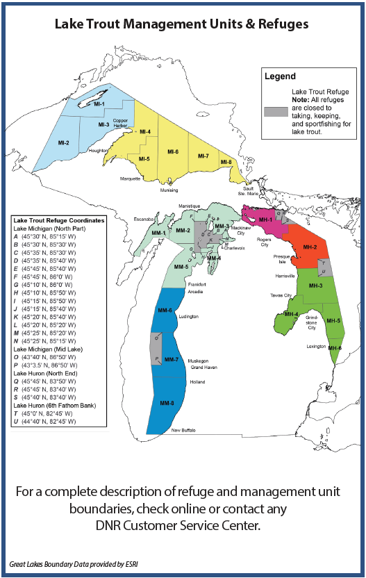
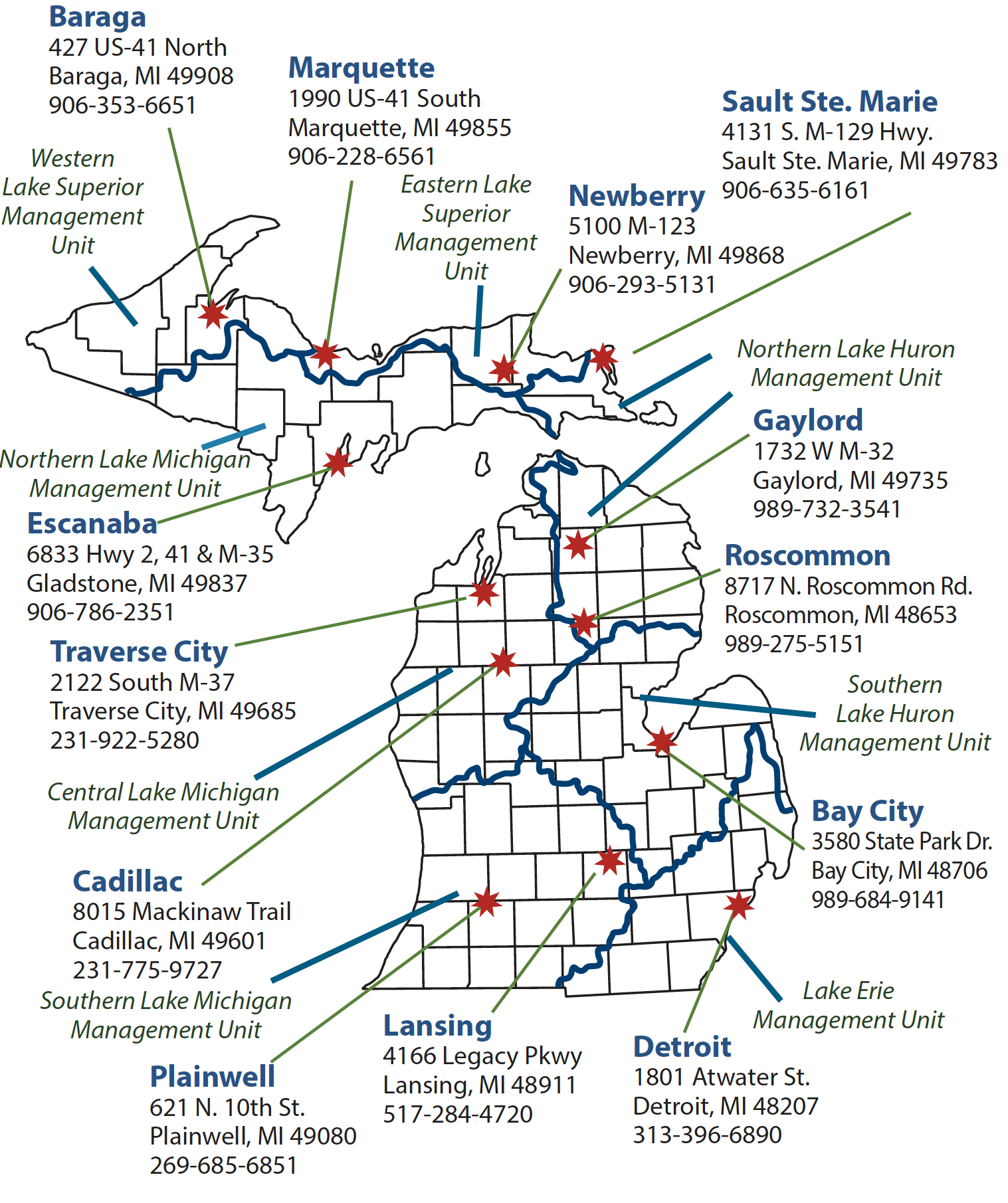
Lake Trout and Splake Regulations: Lake trout and splake regulations for the Great Lakes are listed by Lake Trout Management Unit. The daily possession limit for Lake Trout andSplake is now combined, in any combination. To help identify Management Unit boundaries, a few major ports are listed for each. The map on p. 20 provides a graphic to further define the boundaries. For a complete description of Lake Trout Management Unit boundaries, contact any DNR CustomerService Center or check online at Michigan.gov/DNR.
Michigan's Creel Survey Program
A "creel" is a basket used to collect fish. The Michigan creel survey program is used to collect fish data! When returning from your fishing trip, you may find a creel clerk waiting to interview you and take samples from your fish. Creel clerks collect information about the length of your fishing trip and what fish you caught and released. Biologists use this data to study fish populations, evaluate stocking, and measure the impact of fishing regulations. Creel clerks also wantto listen to your concerns and answer questions.
The next time you see a friendly face in a DNR shirt approaching you with a clipboard, introduce yourself! We appreciate your participation in the survey and thank you for your time.
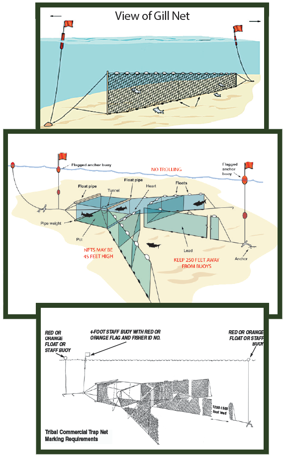
Great Lakes Commercial Fishing or DNR Research Nets
Illustrations courtesy of Michigan Sea Grant
Anglers and boaters on the Great Lakes may encounter commercial fishing gear such as trap nets and gill nets in Michigan waters. All state-licensed or Native American commercial fishing gear are required to be marked with floats or staff/flag buoy combinations depending on the gear type fished and the licensing entity. Anglers and boaters should give wide berth to any markers they see on the water, since the net and anchor lines may extend several hundred feet in any direction from thefloats or flags. The diagrams to the right will give sport anglers and boaters an idea about some of the markings they might encounter and assist them in avoiding entanglement of fishing gear or boat propellers (these are just examples). Tampering with commercial fishing gear and DNR fishing nets is illegal and can create safety problems for other boaters on the water.
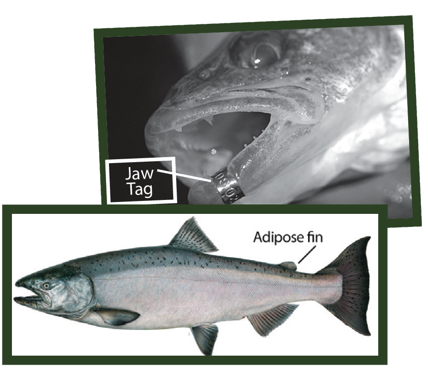
In evaluating fish stocks, the DNR and natural resource partners often mark fish with a visible tag, an internal tag or fin clips. If youcatch a marked fish, please go online at Michigan.gov/EyesInTheField. Here you will be able to report information about your marked fish, such as: species, length, weight, sex, type of mark, tag number (if applicable), and the date and location of catch. Some tags have an associated monetary reward for their return. Anglers catching a reward-tagged fish should report the tag at Michigan.gov/EyesInTheField, and additionally follow any specific instructions on the tag(e.g., contact phone number, address, extraction of internal tag). Please do not remove any tags from Lake Sturgeon.
Many Great Lakes trout or salmon have been marked with a microscopic coded-wire tag implanted in the snout (part of head from behind the eyes forward) of the fish. Fish with these tags can be identified by the absence of the adipose fin. If you catch and keep a trout or salmon with ONLY its adipose fin missing, that fish could have such a tag. Please record the species, length, weight, sex and the date and location of catch; freeze only the snout and take it to your nearest drop off location.Drop off locations can be found at Michigan.gov/ TaggedFish, along with information about most MDNR fish marking studies.
Table 4: Lake Trout & Splake Regulations
For lake trout and splake, the size limit information and the season information is noted in the table below. The daily possession limit for lake trout andsplake (see note) is 3 total combined, with no more than 3 of any one species in any combination, EXCEPT in L. Superior where up to 5 lake trout andsplake combined may be possessed, as noted in Table 4 below.
Any changes will be posted on the DNR website (Michigan.gov/Fishing) and in a pre-recorded message at 888-367-7060.
Lake Trout Management Unit, Major Ports
Possession Season
Size Restrictions (inches)
Lake Trout and Splake CombinedPossession Limit
LAKE SUPERIOR: map color coded by unit regulations
MI 1-3: Windigo, Ontonagon, Copper Harbor
Open All Year
The minimum size limit for lake trout and splake shall be 15"; the daily possession limit shall not include more than 1 lake trout 34" or greater.
3
MI 4-8: Big Bay, Marquette, Au Train, Munising, Grand Marais, Pendills Bay, Brimley State Park
5
LAKE HURON: map color coded by unit regulations
MH 1: DeTour, Cedarville, St. Ignace, Mackinaw City, Cheboygan, Rogers City
Jan. 1 - Sep. 30 (lake trout and splake)
The minimum size limit for lake trout and splake shall be 15".
3
MH-2: Presque Isle, Rockport, Alpena, Black R.
Jan. 1 - Sep. 30 (lake trout and splake)
The minimum size limit for lake trout and splake shall be 15".
3
MH 3-6: Harrisville, Tawas, Grindstone, Harbor Beach, Lexington
Open All Year (lake trout and splake)
The minimum size limit for lake trout and splake shall be 15".
3
LAKE MICHIGAN: map color coded by unit regulations
MM 1-5: Menominee, Escanaba, Manistique, Harbor Springs, Charlevoix, Elk Rapids, Traverse City, Northport, Leland, Frankfort, Platte Bay
Jan. 1 - Sep. 30 (lake trout and splake)
The minimum size limit for lake trout and splake shall be 15".
2
MM 6-8: Arcadia, Manistee, Ludington, Grand Haven, Holland, New Buffalo
Open All Year (lake trout and splake)
The minimum size limit for lake trout and splake shall be 15".
3
Note: The lake trout and splake daily possession limit has been combined between the two species.
AMPHIBIANS & REPTILES
Regulations for Frogs, Toads, Salamanders, Turtles, Lizards & Snakes
Amphibians and reptiles MAY NOT be shot with firearms (including spring, air, or gas propelled), bow and arrow, or crossbow.
The following shall not be taken or possessed except as authorized by the Director of the Department of Natural Resources: Blanding’s, spotted, wood, and eastern box turtles; black rat snake, Butler's garter snake, eastern fox snake, copper-bellied water snake, Kirtland’s snake, queen snake, smooth green snake, and easternmassasauga rattlesnake; boreal chorus frog, Blanchard’s cricket frog, pickerel frog, and Fowler's toad; mudpuppy; small-mouthed salamander, marbled salamander, six-lined racerunner, western lesser siren, northern two- lined salamander, northern dusky salamander, and mink frog; all reptile eggs; and amphibians and reptiles protected under Part 365 (Endangered Species) of 1994 P.A. 451. For further information check online at Michigan.gov/Fishing or contact any Customer Service Center.
Personal Use: A fishing license is required to take amphibians and reptiles for personal use. Reptiles and amphibians may not be bought, sold or offered for sale.
Hand, trap, nets, seines (up to 12 x 4 feet overall dimensions), and hook-and-line may be used. Set lines may not be used to take turtles. Frogs may be speared but NOT with the aid of an artificial light.
Traps must have a plate or tag attached bearing the name and address of the user in legible English. For taking turtles, no more than 3 traps may be used, mesh traps must be no less than 1" mesh, and traps must be set to allow turtles to surface and breathe.
It is illegal to possess or transport in the field, dressed or processed reptiles or amphibians that cannot be measured or identified.
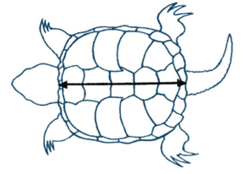
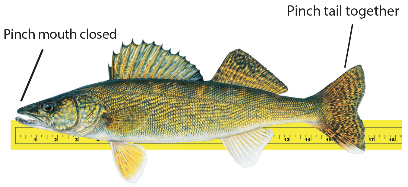
Snapping turtle carapace length: to obtain the carapace (top of shell) length, use a flexible tape to measure from the nuchal scute (the scute directly behind the turtle’s head) to the base of the notch where the two most posterior scutes meet (see image below).
Species
Season
Minimum Size (inches)
Daily Possession Limit
Total
Possession Limit
Frogs, toads, salamanders
Last Sat. in May - Nov. 15
none
10 in any combination
10 in any combination
Snapping turtles (NOTE 1)
July 15 - Sep. 15
13" minimum carapace length
2 in combination (no more than 1 of either species)
4 total in combination (no more than2
of eitherspecies)
Softshell turtles
none
All other turtles (painted, musk, map, red-eared slider); snakes and lizards
Open All Year
none
3 in combination (However, no more than
2 turtles and no more than 1
of any one turtle species)
6 total in combination (However, no more than 4 turtles and no more than
2 of any one turtle species)
Note 1: Carapace length: use a flexible tape to measure from the shell behind the turtle’s head to the posterior end of the shell.
Image courtesy of PA Fish & Boat Commission.
The following restrictions apply for the species, seasons and waters listed below:
Nets and seines may not be fished within 100’ of any dam.
Hand nets may be of any circumference and handle length, except for taking minnows.
Dip nets may not exceed 9' x 9' square and permit is required if equipment is to be left overnight. Permits are available from local DNR Customer Service Center.
There is a two-gallon daily possession limit on smelt.
Seines may not exceed 12’ x 4’ and may only be used for minnows except under a scientific collector’s permit issued by the DNR.
Hoop nets shall be no larger than 36" in diameter and no longer than 7' in length.
NOTE: Check Definitions and Terms for more information.
All Great Lakes, L. St. Clair, St. Clair R., Detroit R., and St. Marys R. including all tributaries to those waters from the mouth to ½ mile upstream (except that Thompson Cr. ([Schoolcraft Co.], is closed). See List A for additional inland streams open to hand netting.
All Lower Peninsula and Upper Peninsula streams, except Designated Trout Streams. See List B for additional streams closed to dip netting.
Dec. 15 –
end of Feb.
Hoop Net
Burbot (permit requiredfrom
local DNR office)
Peshekee R. (Marquette Co.); Au Train R. (Alger Co.) from Au Train L. to mouth; Sturgeon R. (Baraga Co.) from M-38 bridge to mouth; Sturgeon R. (Houghton Co.).
Open all year
Seine, Hand Net, Dip Net
Minnows
All waters, except Designated Trout Lakes & Streams
and those waters closed to minnow harvest (see p.
10).
Open all year
Cast Net
Alewife, Minnows, Smelt, Gizzard Shad
Great Lakes, L. St. Clair, St. Clair R., Detroit R., and St.
Marys R.
*The term “suckers” refers to: suckers (longnose, white, northern hog, spotted), redhorse (silver, golden, black, greater, shorthead), buffalo (bigmouth, black), lake chubsucker, and quillback carpsucker. The term “minnows” refers to small baitfish used as bait: chubs, shiners, dace, stonerollers, sculpins (muddlers), mudminnows, and suckers. Review the netting exceptions list below for regulations that differ from those listed in the table above.
**Review the netting exceptions list below for regulations that differ from those listed in the table above.
Netting Exceptions
LIST A – Additional Inland Waters Open to Hand Netting
The following inland waters are open to use of hand nets from March 1– May 31 for bowfin, carp, goldfish, gizzard shad, longnose gar, smelt and suckers:
Alger: Towes Cr.; W. Br. Whitefish R. from Sea Lamprey Barrier (T44N, R21W, S29) downstream 500’ to posted signs; Charlevoix: L. Charlevoix and tributariesto 1/2 mile upstream; Chippewa: Trout Cr. down from Big Trout L. (T42N, R3E, S31); Prentiss Cr. (T42N, R2E); Delta: Days R. from sea lamprey barrier downstreamfor 500’; Rapid R. from Rapid River Falls (T42N, R21W, S19) down to Co. Rd S15; Escanaba R. from mouth to 1st dam upstream of US-2; Ford R. down fromJaeger Rd.; Houghton: Portage L. and tributaries to 1/2 mile upstream; N. and S. Portage Canal and tributaries to 1/2 mile upstream; Torch L. and tributaries to 1/2mile upstream; Luce: Little Two Hearted R. from mouth upstream to bridge on Co. Rd. 412 (T50N, R9W, S25); Mackinac: Doe Cr. (T43N, R10W, S9); Foley Cr. down from I-75; Hoban Cr. down from State St.; Hudson Cr. (T41N, R11W, S8); Martineau Cr. down from I-75; McClouds Cr.; Milakokia R., Milakokia L. down to Heinz L.; Norton Cr. from M-135 down to S. Manistique L.; Nunn’s Cr. from M-134 to mouth; Pearson’s Cr. (T42N, R1W and R1E); RabbitsBack Cr. down from Mackinac Trail; Scrams Cr. (T42N, R11W, S11); Taylor Cr. (T43N, R12W, S2, 11, 12, 13); Manistee: Little Bear Cr. down from Bear L. to trunkline US-31; Menominee: Big Cedar R. down from mouth of Elwood Cr. (T35N, R25W, S11).
LIST B – Inland Streams Closed to Dip Netting
It shall be unlawful to take or attempt to take any species of fish with dip nets on the following streams:
Arenac: Au Gres R. from Saginaw Bay upstream to M-65 (T22N, R5E, S26); Rifle R. from Steve’s Rd. (T19N, R5E, S9) upstream; Benzie: Cold Cr. from Crystal L. (T26N, R15W, S26) upstream; Grand Traverse: Unnamed Cr. from Green L. (T26N, R12W, S20) upstream to Bridges L.; Iosco: Au Gres R. from Saginaw Bay upstream to M-65 (T22N, R5E, S26); Leelanau: Houdek Cr. from North Lake Leelanau (T31N, R12W, S35) upstream; Monroe: Huron R. from L.Erie upstream to Belleville Dam; Stony Cr. from L. Erie upstream to Finzel Rd. (T5S, R8E, S23); Wayne: Huron R. from L. Erie upstream to Belleville Dam.
MICHIGAN-WISCONSIN BOUNDARY WATER REGULATIONS
Michigan and Wisconsin share several boundary waters and while the states strive to have consistent regulations across the border there are somediscrepancies. Anglers are strongly encouraged to familiarize themselves on fishing regulations for both states. Anglers with a valid Michigan or Wisconsin fishing license can fish either state’s boundary waters, however, anglers are required to adhere to the state- specific regulations based on their location while fishing these shared boundary waters. For example, anglers fishing in Michingan waters must follow Michigan's fishing regulationsand anglers fishing within Wisconsin's portion of the boundary waters must follow Wisconsin's fishing regulations.
The interstate boundary waters in which fishing is to be governed by the special regulations are: The L. Michigan waters between the breakwalls at the mouth of the Menominee R. beginning at an imaginary line drawn between the most lakeward point of each breakwall. Menominee R., its sloughs and impoundments (Menominee, Dickinson, Iron Cos., Michigan; Florence, Marinette Cos., Wisconsin); Brule R. (Iron Co., Michigan; Florence and Forest Cos., Wisconsin); Brule Island Impoundment, upstream to a line runningeast-west through the first island upstream from the junction of the Brule and Paint Rivers (Iron Co., Michigan; Florence Co., Wisconsin); Smoky L. (Iron Co., Michigan; Vilas Co., Wisconsin); Norwood L., Lac Vieux Desert, CrystalL., Mill L., Big Bateau L., Mamie L. (Cisco Chain), West Bay L. (Cisco Chain), Big L. (Cisco Chain), Crampton L., Plum L., Tenderfoot L., RoachL., Little Presque Isle L., Cyrus L., Basin L., Stateline L. (Gogebic Co., Michigan; Vilas Co., Wisconsin); East Fork Montreal R. up to the mouthof Layman Cr. (Gogebic Co., Michigan; Iron Co., Wisconsin); Montreal R. (Gogebic Co., Michigan; Iron Co., Wisconsin).
NOTE: Cowboy Lake (Dickinson Co.), west of Iron Mountain, is NOT part of the MI-WI Boundary Waters.
Legal fishing methods
All residents of Michigan and Wisconsin holding a resident sport fishing license from their respective state, or residents of states other than Michigan andWisconsin holding a sport fishing license issued by either Michigan or Wisconsin may fish in the boundary waters.
Up to 3 lines per person with a total of 3 hooks or baits may be used.
Lines must be attended at all times.
Crayfish may not be possessed or used for bait on Michigan-Wisconsin boundary waters.
Dip nets not exceeding 9 feet square or in diameter, without walls may be used in the Menominee R. from April 1- May 14 for taking of suckers, redhorse, carp, smelt, and burbot (except from Hattie Street Bridge in Marinette- Menominee to Menominee Dam upstream and within 200 feet of all other dams).
Fish shanties used in ice fishing must be legibly marked with the name and address of owner, and persons placing a shanty on these waters shall remove the shanty by midnight of March 15. In Wisconsin boundary waters, fish shanty doors cannot be locked from inside during occupancy.
Weekly Fishing Report
Each week discover the latest fishing hot spots and tips used to catch specific species throughout Michigan—all courtesy of the DNR’s Weekly Fishing Report! Here’s how you can access the report online at Michigan.gov/FishingReport or to your email inbox by signing up atMichigan.gov/DNR.
Table 6: Michigan-Wisconsin Boundary Water Regulations
(Hook & Line Only -- Use of spear, bow & arrow and crossbow prohibited)
Species
Waters
Seasons
Minimum Size (inches)
Daily Possession Limit
Smoky L., Montreal R., and Menominee
R. mouths to 1st
dam.
Open All Year
10"
5
Last Sat. in April - Sep. 30
7"
Brook Trout 8"
Brown Trout 12"
All boundary waters
Open All Year
Catch-and-Immediate-Release
14"
5 in any combination
All boundary waters except rivers and impoundments
1st Sat. in May - March 1
15"
5 in any combination
March 2 - Fri. before 1st Sat. in May
1
5 in any
combination (See NOTE 2)
All boundary waters
1st Sat. in May -
March 1
none
5
All boundary waters
Open All Year
none
25 in any combination
All boundary waters
Open All Year
Catch-and-Immediate-Release
50" (Mandatory
Registration)
(See NOTE 3)
All boundary waters
1st Sat. in Sep. - Sep. 30
60" (Mandatory
Registration)
(See NOTES 3 & 4)
All boundary waters
Open All Year
none
10
All boundary waters
Open All Year
none
10 in any combination
All boundary waters
Open All Year
none
none
NOTE 1: Fishing for trout is not allowed during the closed season in the Brule R. upstream from U.S. Hwy 2 Bridge (T41N, R32W, S9) Iron Co., MI and the Montreal R. above Superior Falls flowage. NOTE 2: On Lac Vieux Desert, the daily limit for walleye is3 with a minimum size limit of 18". NOTE 3: Muskellunge and lake sturgeon harvest are both limited to 1 per angler per year (April 1 - March 31). Anglers who harvest a muskellunge or a lake sturgeon must report by calling 888-636-7778 or by going online at Michigan.gov/RegisterFish. NOTE 4: For the Menominee River, from Grand Rapids Dam downstream to the end of the breakwalls in Green Bay, the daily possession limit for lake sturgeon is 0, catch-and-immediate-release sturgeon fishing only.
MICHIGAN - INDIANA BORDER LAKES
Residents of Indiana or Michigan may fish the whole lake, but must abide by the regulations in the waters they are fishing. Nonresident license holders(for either state) may only fish in the waters under which the jurisdiction applies for that nonresident license. Nonresidents would need Indiana and Michigan nonresident licenses to fish both sides.
South Clear Lake - Indiana, St. Joseph Co./Michigan, Berrien Co., Indiana Lake - Indiana, Elkhart Co./ Michigan, Cass Co., Fish Lake - Indiana,La Grange Co./Michigan, St. Joseph Co., Lake George - Indiana, Steuben Co./Michigan, Branch Co., Long Lake -Indiana, Steuben Co./Michigan,Hillsdale Co.
SYLVANIA WILDERNESS AREA REGULATIONS
The following lakes in Gogebic Co. are subject to special regulations: Banks, East Bear, West Bear, Clark, Corey, Cub, Deer Island, Dorothy, Elsie,Fisher, Florence, Germain, Glimmerglass, Golden Silence, Hay, Helen, High, Honey, Jay, Johnston Springs, Katherine, Kerr, Liluis, Lois, Loon,Louise, Marsh, Moss, Mountain, Snap Jack, Trapper and Whitefish. NOTE: Crooked Lake is covered under general statewide fishing regulations.
Seasons: Statewide seasons apply for all fish species, except that no fishing shall be allowed before the last Sat. in April or after Oct. 31 of each year.
Size Limits
Lake trout: minimum 30"
Walleye: minimum 20"
Northern pike: minimum 30"
All other species: no size limit
Possession Limits
Largemouth and smallmouth bass must be returned immediately to the water without injury andmay not be possessed on the special regulation lakes of the Sylvania Wilderness Area.
Northern pike, walleye and lake trout: not more than 1 fish of any of these species.
All other species: 10 singly or in any combination of species.
Method of Take
Hook-and-line fishing only, not to exceed 3 lines to which may be attached a total of 6 hooks on all lines. All hooks attached to a manufactured artificial lure shall be counted as 1 hook.
Only artificial lures with barbless hooks may be used. “Artificial lure” means any lure that is man-made, in imitation of or as a substitute for natural bait, used to attract fish for the purpose of taking them, and shall include artificial flies. Barbless hooks are defined as a hook from which all barbshave been deleted when manufactured, filed off, or pinched down.
Live bait, dead or preserved bait or organic or processed food may not be used or possessed at any time on special regulation Sylvania Wilderness Area lakes.
VIRAL HEMORRHAGIC SEPTICEMIA VIRUS REGULATIONS
A fish disease called Viral Hemorrhagic Septicemia (VHS) has been found in our state. You can help slow the spread of this and other fish diseases by following the regulations on this page. The regulations in effect focus on the use of fish species which are known to be susceptible to VHS. Visit Michigan.gov/VHS for more information.
Baitfish Exclusion Zones
The following locations are vital to hatchery operations and require greater protection. Therefore,baitfish shall not be used or possessed on the following waters:
Benzie Co.: Brundage Cr. and tribs., Kinney Cr. and Stanley Cr., from its confluence with the Platte R. (T26N, R13W, S7), to their headwaters, including Brundage Spring Pond.
Chippewa Co.: Pendills L. (T47N, R4W, S25, 26) including tributary Pendills Cr. downstream to its confluence with L. Superior (T47N, R4W, S28). Sullivan Cr. from its headwaters (T46N, R4W, S32) downstream to its confluence with the N. Br. of the Pine R. (T45N, R4W, S23). Viddian Cr. from its headwaters (T47N, R4W, S32) downstream to its confluence with Pendills Cr. (T47N, R4W, S28).
Marquette Co.: Cherry Cr. from the location of the Cherry Creek Rd. (T47N, R24W, S18) to the headwaters at County Rd 480 (T47N, R25W, S22).
Wexford Co.: Slagle Cr. from M-37 upstream.
General Statewide Provisions
A person shall not stock baitfish, live fish or roe in public waters of the state prior to receiving a Fish Stocking Permit from the DNR and the permit must be in possession when transporting and stocking the fish.
It is unlawful to import any uncertified live, dead, preserved, frozen and cut baitfish species found on the list of VHS Fish Species (top right) that are not labeledwith their scientific andcommonname, location ofcapture, and testing status including the testing certification number. View Fishing Order 245 at Michigan.gov/Fishing.
Fish caught in a waterbody should only be released into the waterbody where originally caught and not transferred into another location where the fish could not have freely moved to.
All baitfish or fish collected for personal use as bait or cut bait shall only be used for fishing purposes in the original waters of collection and must be used on a hook.
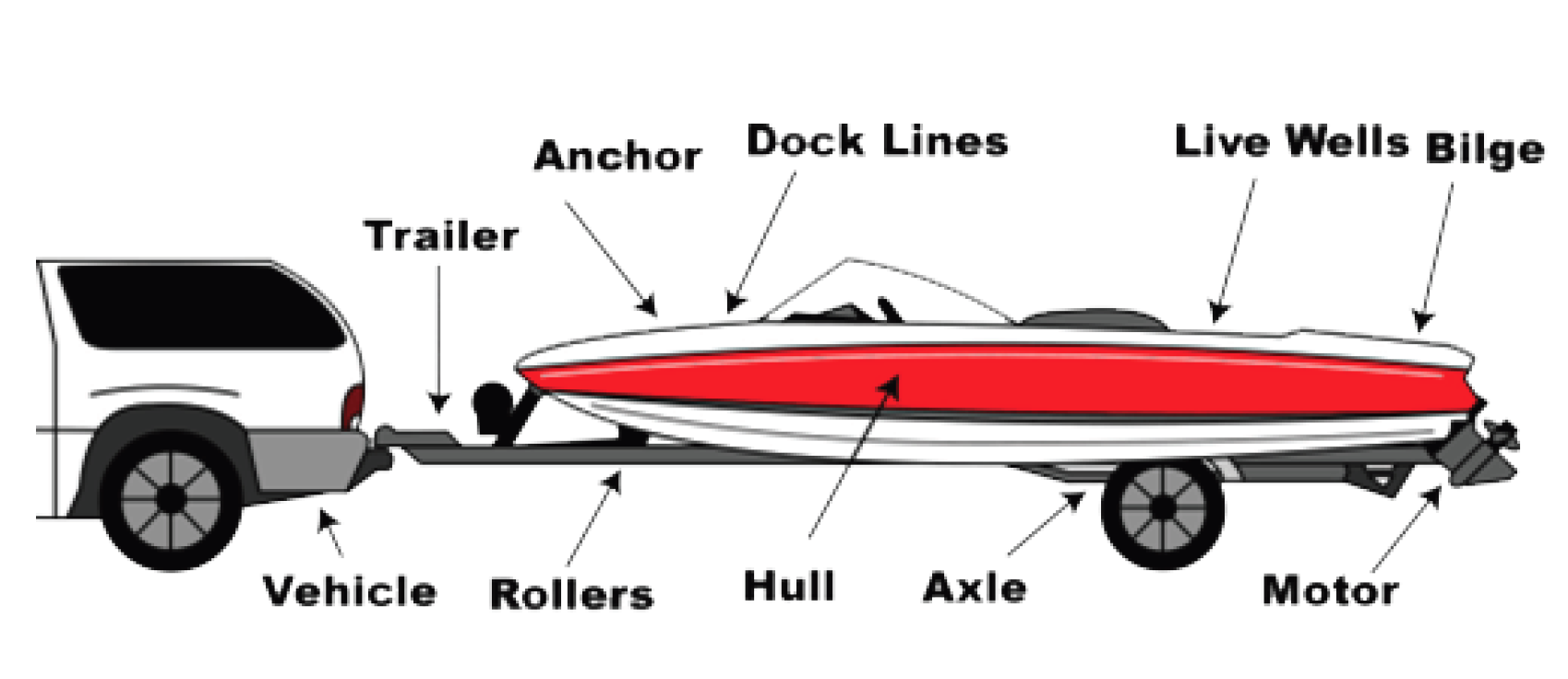
A person who trailers a boat over land shall drain all water from the live well(s) and the bilge of their boatupon leaving any body of water.
It shall be unlawful to purchase and use baitfish, crayfish, or other live organisms from any location not licensed under Part 487 of 1994 PA 451 including, but not limited to, pet shops and live fish markets.
VHS Fish Species (susceptible to VHS)
Anchovies
Atlantic herring
Atlantic menhaden
Atlantic salmon
Black bullhead
Black crappie
Bluegill
Bluntnose minnow
Brook trout
Channel catfish
Cisco (lake herring)
Common shiner
Creek chub
Emerald shiner
Eulachon
Flathead minnow
Flathead catfish
Gizzard shad
Golden shiner
Green sunfish
Hybrid sunfish
Lake trout
Lake whitefish
Largemouth bass
Muskellunge
Northern pike
N. redbelly dace
Pacific herring
Pumpkinseed
Rainbow smelt
Rainbow trout
Redear sunfish
Rock bass
Sand shiner
Smallmouth bass
Spotfin shiner
Spottail shiner
Walleye
Warmouth
White bass
White crappie
White sucker
Yellow bullhead
Yellow perch
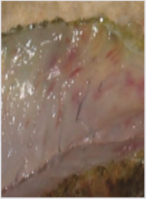
VHS Clinical Signs
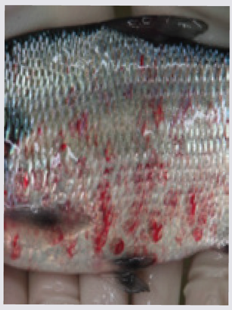
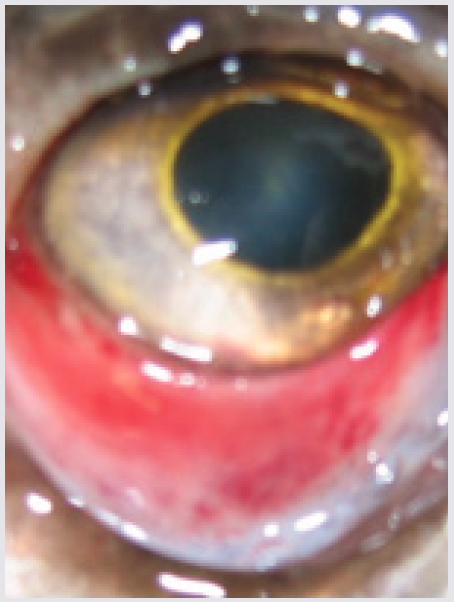
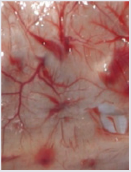
Photos from Dr. Mohamed Faisal, MSU
Hemorrhagic areas on skin
Gizzard shad, Lake St. Clair
Hemorrhagic areas near eye
Yellow perch, Lake St. Clair
Typical hemorrhagic areas in swim bladder
Yellow perch, Lake St. Clair
Hemorrhagic areas in muscle tissue
Yellow perch, Lake St. Clair
Exceptions to General Regulations by County
Many water bodies have special regulations that differ from the general Hook & Line Fishing (Table 1), General Netting (Table 5), and Bow and Spear Fishing regulations (Table 3). The following is a list of waters, organized by county, with special regulations that are NOT included in the following sections of the Fishing Guide: General Regulations tables cited above;Special Northern Pike and Muskellunge Regulations; Michigan-Wisconsin Boundary Regulations; and Sylvania Wilderness Area Regulations.
Alger:
Rock R. closed to fishing from dam to lower foot bridge downstream from M-28 April 1 - June 30. Duck and Echo Lks. (Grand Island), catch-and release on smallmouth bass. Pictured Rocks National Lakeshore (contact park for regulation specifics 906-387–3700).
Allegan:
Swan Cr. from mouth upstream to the dam on 118th Ave. restricted to only one single-pointed, unweighted hook no larger than 1/2" from point to shank.
Antrim:
Intermediate R. closed to all fishing from Bellaire Dam to M-88 Bridge April 1 - May 14. Torch R. from the Crystal Beach Rd Bridge downstream to L. Skegemog including Rapid R. up to Aarwood Rd Bridge - From May 1 - July 1, it shall be unlawful to use other than one single-pointed unweighted hook measuring 1/2-inch or less from point to shank.
Arenac:
Saganing Cr. (upstream from State Rd.) and Pine R. (upstream from State Rd.) closed to fishing March 16 - Fri. before last Sat. in April.
Baraga:
Lakes of Craig Lake State Park (Clair, Craig, Crooked, Keewaydin, Nelligan, Teddy, and Thomas Lks.) artificial lures only; northern pike, muskellunge, largemouth bass, and smallmouth bass must be released, minimum size on walleye is 15", no size limit on other species; possession limit on walleye is 2; otherwise, all general rules apply. Motorboats of all types prohibited on all except Thomas and Keewaydin Lks.; Sturgeon R. from Prickett Dam downstream to mouth of Clear Cr. (T50N, R35W, S12) closed to all fishing April 1 - June 30.
Barry:
Williams L. open season is last Sat. in April - Dec. 15, catch-and-immediate-release only.
Bay:
Kawkawlin R. and all tributaries upstream of Euclid Ave., and Saganing Cr. (upstream from State Rd.) and Pine R. (upstream from State Rd.) closed to fishing March 16 - Fri. before the last Sat. in April. On the Kawkawlin R. downstream from Euclid Ave. and the Saginaw R. from upstream of the West Center Street (Douglas G. Schenk) Bridge and all tributaries, the following regulations apply from March 16 - Fri. before the last Sat. in April: Anglers are limited to using unweighted single- pointed hooks, natural bait, and sinkers or weights or artificial lures with unweighted single-pointed hooks.
Benzie:
Platte R. restricted to only one single-pointed, unweighted hook no larger than 1/2" from point to shank; closed to fishing within 300 ft. of upper (hatchery) weir and lower weir whenever either weir is in place; closed to fishing from US-31 bridge at Veteran’s Park downstream to Platte L. Jan. 1 – March 31. Betsie R. Homestead Dam closed to fishing Nov. 16 - July 31 within 100 feet of lamprey barrier and fish passage facility (T25N, R15W, S2). Betsie River Homestead Dam closed to fishing from August 1 – November 15 within 300 feet of the lamprey barrier and fish passage facility (T25N, R15W, S2). On all waters of the Betsie R. special artificial lure regulations apply.
Berrien:
Townsend Cr. (T6S, R17W, S19), and the mouth area of Lake Chapin, to a point 100 yards below the Townsend Cr. mouth into Lake Chapin), it is unlawful touse other than one single-pointed, unweighted hook measuring 1/2" or less from point to shank.
Calhoun:
Harts L. catch-and-release only for all species.
Cass:
Corey, Little Crooked and Stone Lks. bass minimum size limit is 10". Indiana L. no possession of cisco (lake herring).
Charlevoix:
Medusa Cr. and area of L. Michigan for a radius of 100’ of mouth closed to fishing when weir is in place. Boyne R. from mouth upstream to dam (T32N,R5W, S5) restricted to one single-pointed, unweighted hook no larger than 1/2" from point to shank. On L. Michigan, within one-half mile of the following islands of the Beaver Island Archipelago: Beaver, Garden, High and Hog the possession season for largemouth and smallmouth bass is July 1 - Dec. 31 and open to bass catch-and-immediate-release all year.
Cheboygan:
Cheboygan R. from the south end of the outermost breakwall at Mullett L. downstream to Cheboygan Dam, and Black R. from Alverno Dam downstream to its confluence with the Cheboygan R. the possession season for walleye shall be May 15 - March 15. Cheboygan R., Indian R., or Black R. unlawful to fish during April 1 - June 15 with spear, bow and arrow, crossbow, dip net or gaff. Black R. between Kleber Dam and Red Bridge (T35N, R1E, S5) unlawful to fish in any manner during April 1 - June 15. Lower Black R. from Alverno Dam down to Mograin Bridge, no fishing April 1 - May 14. Black L. and tributaries no commercial minnow take; sturgeon fishing prohibited except under special season.
Chippewa:
Potagannissing R. from Potagannissing Dam downstream to Maxton Rd. (T42N, R6E, S15) closed to fishing March 16 - May 14.
Crawford:
Wakeley L. open season last Saturday in April – September 30, catch-and-release fishing with artificial lures only. It shall be unlawful to use or possess live bait, dead bait or organic or processed food at any time on the shore or water. Jones L. open season last Saturday in April – September 30, catch-and-release fishing with artificial lures only. It shall be unlawful to use or possess live bait, dead bait or organic or processed food at any time on the shore or water.
Delta:
Little Bay de Noc north of a line drawn from Peninsula Point Lighthouse to the mouth of the Bark R.; no more than 1 walleye 23" or greater in daily possession limit. Rapid R. Borrow Pit (Stockyard Pond, T40N, R21W, S5) closed to fishing all year.
Dickinson:
See also Michigan-Wisconsin Boundary Waters Regulations (see pp. 24-25). Fumee L. county ordinance currently prohibits access for the purpose of fishing.
Emmet:
Bear R. from foot bridge north of Lake Street upstream to Lake Street Dam (T34N, R5W, S6) restricted to one single-pointed, unweighted hook no largerthan 1/2" from point to shank.
Genesee:
Flint R. downstream from Holloway Dam and all tributaries, the following regulations apply from March 16 - Fri. before the last Sat. in April: Anglers are limited to using unweighted single-pointed hooks, natural bait, and sinkers or weights or artificial lures with unweighted single-pointed hooks.
Gogebic:
L. Gogebic the daily possession limit for yellow perch is 25 with no more than 5 yellow perch 12" or greater. See also Michigan-Wisconsin Boundary Waters Regulations. Sylvania Wilderness Area regulations.
Grand Traverse:
Boardman R. closed to fishing whenever weir is in place from the downstream side of the Front Street Bridge to the upstream side of the pedestrian bridge in the vicinity of the Boardman River weir in Traverse City. Arbutus and Spider Lks. bass minimum size limit is 10".
Ionia:
Woodard L. bass minimum size limit is 10".
Iosco:
Au Gres R. from 50’ upstream of Allen Rd. bridge to 500’ downstream closed to all fishing March 16 - Fri. before last Sat. in April. E. Br. Au Gres R. between DNR lamprey barrier and Legget Rd. closed to fishing Dec. 1 - Fri. before last Sat. in April. Au Sable R. from Foote Dam downstream to the downstream edge of the apron of the dam closed to fishing all year.
Iron:
See also Michigan-Wisconsin Boundary Waters Regulations (see pp. 24-25). L. Ottawa no possession of bass. Fire and Indian Lks. bass possession limit is1 fish and minimum size limit is 18".
Kalkaska:
Cub L. (T27N, R5W, S19) bass minimum size limit is 10". Torch R. from the Crystal Beach Rd Bridge downstream to L. Skegemog including Rapid R. up to Aarwood Rd Bridge - From May 1 - July 1 - it shall be unlawful to use other than one single- pointed unweighted hook measuring 1/2-inch or less from point to shank.
Kent:
Pratt L. bass minimum size limit is 10".
Keweenaw:
Isle Royale National Park: Michigan fishing laws apply and state license required on L. Superior waters of park. On L. Superior, within 4.5 miles of IsleRoyale, no possession of brook trout. (Contact park for specific regulations 906-482-0984 or www. nps.gov/isro/planyourvisit/fishing.htm.)
Lake:
Little Manistee R. 300’ above and below the DNR weir is closed to fishing all year; from 300’ above DNR weir to Spencers Bridge closed to fishing Jan. 1 - March 31; also from 300’ below DNR weir to mouth closed to fishing Sep. 1 - Nov. 14 and Jan. 1 - March 31. On all waters of the Pere Marquette R. and Little Manistee R. an artificial lure is defined as a body bait, plug, spinner or spoon. Big Bass L. (T20N, R14W, S34) bass minimum size limit is 10".
Leelanau:
North Manitou L. bass minimum size limit is 18", the possession limit is 1; fishing restricted to artificial lures only; live bait, dead or prepared bait or organic orprocessed food may not be possessed on the water or the shore. Florence L. (S. Manitou Is.) fishing restricted to artificial lures only; live bait, dead or prepared bait or organic or processed food may not be possessed on the water or the shore. Hatlem's Cr., it is unlawful to take or attempt to take minnows for personal use.
Livingston:
Spring Mill Pond (Island Lake Recreation Area) March 15 - March 31 no fishing; April 1 - Fri. before the last Sat. in April, catch-and-immediate-release of trout with artificial lures only; last Sat. in April - March 14 statewide regulations apply.
Luce:
Unlawful to launch or retrieve motorized vessel (greater than 5 horsepower) from state land on the E. Br. Fox R. from M-28 to the mouth of Cold Cr.
Macomb:
Clinton R. cut-offchannel(T2N, R13E): from spillway weir to the Harper Rd. Bridge: the following regulations apply from March 16 - Fri. before the last Sat. in April: Anglers are limited to using unweighted single- pointed hooks, natural bait, and sinkers or weights or artificial lures with unweighted single-pointed hooks.
Manistee:
Little Manistee R. 300’ above and below the DNR weir is closed to fishing all year; from 300’ above DNR weir to Spencers Bridge closed to fishing Jan. 1 - March 31; also from 300’ below DNR weir to mouth closed to fishing Sep. 1 - Nov. 14 and Jan. 1 - March 31. On all waters of the Betsie R., all waters of Bear Cr. (Manistee Co.), all waters of the Little Manistee R., and the Manistee R. from Tippy Dam downstream to Railroad Bridge below M-55 (T21N, R16W, S6), special artificial lure regulations apply.
Marquette:
Deer L. Basin, Carp R./Carp Cr. downstream from M-28 (T47N, R27W, S4), and all other tributaries to Deer L. Basin fishing restricted to artificial lures, catch-and-release only; live bait, dead or prepared bait or organic or processed food may not be possessed on the water or the shore. Fish L. bass minimum size 18" and possession limit is 1 bass only. Salmon-Trout R., from Lower Falls to mouth closed to fishing Aug. 15 - Fri. before last Sat. in April.
Mason:
On the Sable R. from mouth upstream to Hamlin Lake Dam, all waters of the Little Manistee R., all waters of the N. Br. Pentwater R., and on all waters of the Pere Marquette R. special artificial lure regulations apply.
Menominee:
Lake Michigan waters of Green Bay: see also Michigan-Wisconsin Boundary Waters Regulations.
Midland:
Tittabawassee R. between Sanford Dam site and mouth of the Salt R. and between Dow Dam and Gordonville Bridge, closed to fishing from March 16 - Fri. before last Sat. in April. Tittabawassee R. downstream from Sanford Dam site, Chippewa, Pine, Salt and all their tributaries the following regulations apply from March 16 - Fri. before the last Sat. in April: Anglers are limited to using unweighted single-pointed hooks, natural bait, and sinkers or weights or artificial lures with unweighted single-pointed hooks.
Monroe:
Crystal Waters State Game Area for all waters - the fishing season is open all year and no possession allowed, catch-and-immediate-release fishingonly.
Montmorency:
East Fish, West Fish, and Middle Fish Lks., Hunt Cr. (above Section Z bulkhead T29N, R2E, S25), and Fuller Cr. (in the Hunt Cr. Trout Research Station Area), no fishing. North and South Blue and Walled Lks., open season is the last Sat. in April - Sep. 30, catch-and-immediate-release only, artificial lures only.
Muskegon:
On all waters of the White R. (from mouth upstream to Hesperia Dam) and all waters of the N. Br. White R. and Muskegon R. (upstream to Croton Dam) special artificial lure regulations apply.
Newaygo:
Baptist L., no possession of walleye, channel catfish, flathead catfish or bullheads; Brush and Sand Lks. no possession of channel catfish, flathead catfish or bullheads. Crystal L., no possession of walleye. On all waters of the Pere Marquette R. and Muskegon R. (upstream to Croton Dam) special artificial lure regulations apply.
Oakland:
Upper Bushman L. catch-and-immediate-release only for all species.
Oceana:
On all waters of the Pere Marquette R., White R. (from mouth upstream to Hesperia Dam) and all waters of the N. Br. White R. and all waters of the N. Br.Pentwater R. and S. Br. Pentwater R. (upstream to Hart Dam) special artificial lure regulations apply.
Ontonagon:
L. Gogebic the daily possession limit for yellow perch is 25 with no more than 5 yellow perch 12" or greater. W. Br. Ontonagon R. from its confluence with the Victoria Hydro station tailrace (T50N, R39W, SE 1/4 of the SW 1/4 of S29) upstream to Victoria Dam, including the trailrace canal closed to fishing April 1 - Jun. 10. Lake of the Clouds fishing restricted to artificial lures only. It shall be unlawful to use or possess live bait, dead bait or organic or processed food at any time on the shore or water. No spearing, no possession of smallmouth bass. Ontonagon R. no more than 1 walleye over 23" may be possessed in the daily possession limit.
Otsego:
Otsego L. Pike Marsh closed to fishing March 16 - June 15. Otsego L. for lake sturgeon regulation.
Presque Isle:
Clinton Cr. closed to fishing April 1 - May 14. Grand L. Pike Marsh unlawful for any person other than state employee to use or operate a motorized vehicle on the access road leading from US-23 to the Grand L. Pike Marsh during March - May, closed to fishing whenever marsh is operating. Rainy R. from confluence with Black L. upstream to N. Allis Rd. Bridge (T35N, R2E, S15) closed to fishing April 1 - May 14. Shuberts Cr. (Monaghan Cr.) from Long L. upstream to Clinton Cr. Rd. (T33N, R7E, S14), closed to fishing April 1 - May 14. Swan R. from 300’ above weir to mouth closed to fishing whenever weir is in place.
Roscommon:
Denton Cr. from the Lake James Dam downstream to Houghton L. closed to fishing March 23 - April 23. Cut R. from confluence with Backus Cr. upstream to outlet at Marl L. closed to fishing March 23 - April 23.
St. Joseph:
Big Pleasant and Corey Lks. minimum size limit for bass is 10".
Saginaw:
Bad R., Cass R., Flint R., Saginaw R. from upstream of the West Center Street (Douglas G. Schenk) Bridge, Shiawassee and Tittabawassee Rivers and all their tributaries the following regulations apply from March 16 - Fri. before the last Sat. in April: Anglers are limited to using unweighted single-pointed hooks, natural bait, and sinkers or weights or artificial lures with unweighted single- pointed hooks.
Schoolcraft:
Thompson Cr. closed to use of hand nets. Seney National Wildlife Refuge waters have limited fishing, contact Refuge office (906-586-9851) or visit www.fws.gov/refuge/Seney. On the Big
Island Lakes Complex (Big Island, Bluegill, Byers, Center, Coattail, Cucumber, Farm [Blush], Jarr, Klondike, McInnes, Mid, Neville, Onega, Pear, Townline, Upper and Vance) no wheeled or motorized vehicles (including electric
or outboard motors) are allowed; artificial lures only; no spearing, no netting, and use of live bait prohibited; muskellunge (including tiger muskellunge) fishing season is May 15 - Nov. 30, possession season is 1st Sat. in June - Nov. 30, minimum size limit 42", possession limit is 1 fish per angler per season, anglers must register all harvested muskellunge; northern pike open season May 15 - Nov. 30, minimum size limit 24", and possession limit is 2 northern pike; bass fishing is open from Sat. before Memorial Day - Nov. 30, minimum size limit 18", and possession limit is 1; perch, bluegill andpumpkinseed open season is from last Sat. in April – Nov. 30, possession limit is 5 fish in combination; all other fish no open season. Unlawful to launch or retrieve motorized vessel (greater than 5 horsepower) from state land on the E. Branch Fox R. from M-28 to the mouth of Cold Cr.
Van Buren:
Crooked and Little Crooked Lks. bass minimum size limit is 10". S. Br. Black R. and all tributaries upstream of Breedsville (Mill Str.) restricted to only one single-pointed, unweighted hook no larger than 1/2" from point to shank.
Washtenaw:
Huron R. from Mast Rd. Bridge in Dexter (T1S, R5E, S32) downstream to Delhi Rd. Bridge (T2S, R5E, S2) catch-and-immediate-release only on bass. Horseshoe L. bass possession limit is 1, minimum size is 14"; northern pike possession limit is 1, sunfish (NOTE 6) possession limit is 10.
EAT SAFE FISH – Michigan’s Eat Safe Fish Guide
There are many health benefits to eating fish. However, to get the most benefits, the Michigan Department of Health and Human Services (MDHHS) recommends eating fish that are low in chemical contaminants. You can use the Eat Safe Fish Guide (ESF Guide) to find fish that have been tested for chemicals and are safe for everyone to eat.
MDHHS tests only the parts of the fish that you eat for chemicals. That’s the information used to make the guidelines inthe ESF Guide.
The guidelines in the ESF Guide are safe for everyone to use - including pregnant women, children, and those with illnesses, like cancer or diabetes.
You can’t see or taste the chemicals that can cause health problems. The only way to know if they’re in your fish is to use the MDHHS ESF Guide. Get yours today!
Chemicals can be found in fish from anywhere in the world. The Eat Safe Fish Guide can help you find safer options when eating fish from Michigan. To get a free copy of the MDHHS Eat Safe Fish Guide and other helpful information about choosing and eating safe fish, visit Michigan.gov/EatSafeFish or call MDHHS at 1-800-648-6942.
Be aware of PFAS
The Michigan Department of Health & Human Services releases Eat Safe Fish Guides annually in the spring and emergency advisories as needed. Fish across the state are tested for PFAS (per- and polyfluoroalkyl substances).
Additionally, they are tested for other chemicals such as mercury as all fish have some amount of mercury. As new guidelines are set as a result of elevated levels of PFAS, Michigan is releasing those advisories outside of the annual Eat Safe Fish Guides update. To be
sure you have the most up-to-date information about PFAS fish results, visit Michigan.gov/PFASResponse.
ANGLER RIGHTS ON PUBLIC STREAMS
Angler Rights On Public Streams
On fenced or posted property or farm property, an angler wading or floating a navigable public stream (for more information call the DNR's Law Enforcement Division at 517-284-6000) may, without written or oral consent, enter upon property within the clearly defined banks of the stream, orwithout damaging farm products, walk a route as closely proximate to the clearly defined bank as possible when necessary to avoid a natural or artificial hazard or obstruction, including, but not limited to a dam, deep hole or fence or other exercise of ownership by the riparian owner.
However, per the Michigan Penal Code Section 552c, a person is prohibited from intentionally and without authority or permission from entering in or upon premises or structures belonging to another person that is a "key facility" if that key facility is completely enclosed by a physical barrier of any kind. A key facility includes: a chemical manufacturing facility; a refinery; an electric utility facility; a water intake structure or water treatment facility; a natural gas facility; gasoline, propane, liquid natural gas, or other fuel terminal or storage facility; a transportation facility; a pulp or paper manufacturing facility; a pharmaceutical manufacturing facility; a hazardous waste storage, treatment or disposal facility; and a telecommunication facility.
Railroad Rights-Of-Way
Railroad rights-of-way are private property. Trespassing on railroad property, including the trestles and bridges, is a misdemeanor. Written permission must be obtained from the railroad company to be exempt from railway trespass.
Angler Harassment Information
Anglers in Michigan have the right to enjoy their sport free from unreasonable and deliberate interference. Michigan law prohibits individuals from obstructing or interfering with the lawful taking of aquatic species. The DNR supports fishing as a legitimate form of recreation and as a useful tool in the management of aquatic resources. Michigan Conservation Officers are committed to protecting anglers from the intentional disruption of the fishing experience. Individuals whose fishing is being obstructed should promptly report the violation by calling or texting toll free to 800-292-7800 (Report AllPoaching hotline).
Personal Flotation Devices (PFD)
When selecting a PFD, be sure to read the label to verify that it is appropriate for the person's size, weight and intended activity. Try your PFD on to make sure it fits properly and check to make sure it is U.S. Coast Guard approved.
Craft under 16 feet long:
For Great Lakes and connecting waterways, the U.S. Coast Guard requires all vessels less than 16 feet to carry one wearable U.S. Coast Guardapproved life jacket for each person on board. For inland waters not connected to the Great Lakes, each person on board must have either a wearable or throwable PFD.
Craft 16 feet or longer:
If your boat is 16 feet or longer, you must have at least one U.S. Coast Guard approved wearable PFD for each person on board:
Offshore Life Jacket (Type I)
Near-shore Bouyant Vest (Type II)
Flotation Aid (Type III)
PLUS you must have one throwable PFD (Type
on board:
Michigan law requires:
Everyone operating, riding on or being towed by a personal watercraft must wear a non-inflatable Type I, II or III PFD.
Persons less than 6 years old must wear a Type I or Type II PFD when riding on the open deck area of a boat.
MASTER ANGLER INFORMATION
The Master Angler Patch is awarded to all entries meeting the established minimum length criteria and that adhere to program requirements described below. All fish must be taken by legal Michigan sportfishing methods, during the open season, and in Michigan waters OPEN TO THE PUBLIC. A photo of the fish being measured by a standard ruler or measuring tape MUST be included in the entry application. Only one entry will be accepted per fish species that are the same length and submitted by the same angler. DNR Fisheries Division reserves the right to reject any application if theentry does not meet the established criteria. Only 1 patch per species will be awarded to each angler per year.
The Master Angler patch is awarded to anglers who meet the species-specific minimum length and other program requirements. Anglers catching a State Record fish also receive a patch.
Measuring the length of your fish: Measure your fish from the tip of the nose (or lower jaw) to tip ofthe tail in a straight line. Do NOT measure in a curve or over the body. Measure to the closest 1/8". Use a standard ruler or measuring tape and take a picture while measuring the fish as required for the program.
Applications are only accepted via the online form found at Michigan.gov/MasterAngler. The deadline for submitting an entry is Jan. 10, 2024. Color photos of the fish, including at least one of the entire fish being measured with a device that clearly shows and verifies the length must be submitted along with the application. Applications and photos may ONLYbe submitted via the online form. Need help submitting? Call 517-284-5830.
State Record Fish are recognized by weight only. To qualify, your fish must exceed the current listed State Record weight and identification must be verified by a DNR fisheries biologist. See the list of Customer Service Centers and plan on calling ahead for fisheries biologist availability.
Measure fish from tip of nose (or lower jaw) to tip of tail in a straight line (DO NOT measure in a curve around the body from nose to tail). Measure to the closest 1/8". Tail and jaw should be pinched to get proper measurement.
When releasing a fish...
Please follow these suggestions to reduce the risk of injury to the fish when practicing catch-and-release:
Never use a gaff.
Land your catch carefully and quickly. Avoid handling the fish at all and remove the hook gently with pliers.
Use a landing net made of soft or knotless mesh and always try to net your fish head first.
Try to keep the fish in the water and gently cradle it while carefully removing the hook.
Leave your fish in the water until you are ready to take a photo.
Do not squeeze the fish and keep your fingers out of the fish’s gills since a torn gill could cause the fish to bleed to death.
Touch your fish as little as possible. Always wet your hands before touching your fish.
Cut the line near the hook if a fish is deeply hooked. A steel hook will rust away leaving the fish unharmed.
Release your fish, pointing it into a slow current or gently moving it back and forth until its gills are working properly and the fish regains its balance. Once fully recovered, allow the fish to swim from your hands (large fish may take longer to recover).
Minimum Entry Lengths & Current State Records
Must meet minimum length and include a picture of fish being measured. Submit entries at Michigan.gov/MasterAngler
The information in this section provides fishing regulations that pertain only to the taking of trout and salmon from inland waters. Check the county listings on for specific waters and the regulations placed on each according to the Type listed for that entry. Regulations for lakes and streams are listed in either the lake regulations table (below), stream regulations table, or the gear restricted streams section. Maps have been developed to assist anglers in identifying inland trout waters and the regulations associated with each Type as indicated by color scheme and text. Maps are only available online at Michigan.gov/Fishing. During closed season dates on inland trout and salmon waters, fishing is prohibited for all species. Anglers shouldcheck the It is Unlawful To section for restrictions on hooks and lures and the Exceptions to General Regulations by County for otherrestrictions.
FO - Flies Only
ALO - Artificial Lures Only
A person shall not at any time take, attempt to take, or possess an Arctic Grayling taken from any of the waters over which the state hasjurisdiction.
The following regulations pertain only to inland lake Types A - F as listed. Maps are available online at: Michigan.gov/FishingGuide
Lake Type
Fishing and Posession Season
Tackle
Daily Possession Limit
Brook Trout
Brown Trout, Rainbow Trout, & Splake
Lake Trout
Coho, Chinook, & Pink Salmon
Atlantic Salmon
Minimum Size Limit (inches)
A
(61
lakes)
Last Sat. in April - Oct. 31
All except minnows
5/3*
10"
12"
15"
10"
15"
B
(55
lakes)
Open All Year
All
5/3*
10"
12"
15"
10"
15"
C
(28
lakes)
Open All Year
All
5/3*
8"
8"
8"
10"
15"
D
(21
lakes)
Last Sat. in April - Oct. 31
ALO
**
1
15"
15"
15"
10"
15"
E
(11
lakes)
Open All Year
All
3
15"
15"
15"
10"
15"
F
(16
lakes)
Open All Year
All
5/3^
10"
10"
10"
10"
10"
* 5 fish, with no more than 3 trout 15“ or greater.
** On Type D lakes, it is unlawful to use or possess live bait, dead or preserved bait or organic or processed food on any of the waters or on shore.
^ 5 fish in any combination, but no more than 3 fish of any one species, except up to 5 salmon (Chinook or coho) may be retained.
Designated Trout Lakes:
All Type A and all Type D lakes are designated trout lakes.
Regulations for Lakes Not Classified as Lake Type:
Except for lakes in the Michigan-Wisconsin Boundary Waters and Sylvania Wilderness Area, any other inland lake not classified by Type is open all year to the taking of trout with an8-inch minimum size limit and 5 fish daily possession limit, no more than 3 of which may be 15" or greater. Artificial lures and all types of natural bait may be used. See pp. 24-26 forMichigan-Wisconsin Boundary Waters and Sylvania Wilderness Area regulations, respectively.
The following regulations pertain only to inland stream Types 1-4, and Brook Trout Restoration Areas (BTRA). Maps are available online at: Michigan.gov/Fishing.
All types of natural and artificial baits may be used on stream
Types 1-4. NOTE: Chumming is prohibited on all stream types listed below and Gear Restricted Streams.
Minimum Size Limit (inches)
Daily
Possession Limit
StreamType (Colors below areindicated
accordingly on the maps online.)
Fishing Season
Possession Season
Brook Trout
Brown Trout
Atlantic,
Chinook,
Coho & Pink Salmon,
Lake Trout, Rainbow Trout (Steelhead), Splake
All Trout and Salmon
1
(Approx. 1,400 streams)
Last Sat. in April - Sep. 30
Last Sat. in April
- Sep. 30
7"
8"
10"
5 fish, but no more than 3 trout
15" or greater
2
Last Sat. in
Last Sat. in April
10"
12"
(13 streams)
April - Sep. 30
- Sep. 30
3
Open All Year
Open All Year
15"
15"
(58 streams)
Last Sat. in
April - Sep. 30
for Brook Trout,
4
(128 streams)
Open All Year
Brown Trout, and
Atlantic Salmon
7"
10"
Open all year for
all other Trout and
Salmon
Brook Trout Restoration Areas (BTRA)
The following locations have more restrictive brook trout regulations. Fishing regulations on these waters shall supersede those in other sections which in any way conflict with the following: the harvest season for Brook Trout is from the last Saturday in April - Sep. 30, the minimum size limit on Brook Trout, Lake Trout, and Splake shall be 20 inches with a daily possession limit of one (1) Brook Trout, Lake Trout or Splake total combined.
Big Garlic River and tributaries (Marquette Co.), from County Road 550 (T50N, R26W, S33) downstream to Lake Superior (T50N, R26W, S21).
Big Huron River (Baraga and Marquette Cos.), from Big Eric’s Bridge (T52N, R30W, S35) downstream to Lake Superior (T52N, R29W, S18).
Iron River (Marquette Co.), from Lake Independence Dam (T51N, R27W, S13) downstream to Lake Superior (T51N, R26W, S18).
Little Huron River (Marquette Co.), from unnamed bridge crossing located at the southern border of section 20 (T52N, R29W, S20) downstream to Lake Superior (T52N, R29W, S17).
Pilgrim River and tributaries(Houghton Co.), from the headwaters downstream to Portage Lake (T54N, R33W, S5).
Portage/Torch Lake system (including the Portage River, Portage Canal, North Entry and South Entry, Houghton Co.).
Ravine River (Baraga Co.), from Sicotte Road (T51N, R31W, S2) downstream to Huron Bay (T51N, R31W, S4).
Silver River (Baraga Co.), from Silver River Falls (T51N, R32W, S26) downstream to Huron Bay (T51N, R31W, S18).
Slate River (Baraga Co.), from Slate River Falls (1/2 mile upstream from Skanee Road T51N, R31W, S9) downstream to Huron Bay (T51N, R31W, S8).
Salmon-Trout River (Marquette Co.) from Lower Falls (T51N, R28W, S13) down to Lake Superior. NOTE: Fishing season: last Saturday in April - August 14; Possession season: last Saturday in April - August 14.
Regulations for Streams Not Classified as Stream Type or Listed as a Gear RestrictedStream
Except for streams in the Michigan-Wisconsin Boundary Waters, any other inland stream not classified by Type is open to trout fishing all year with an 8"minimum size limit (except 7" for brook trout) and a 5 fish daily possession limit, no more than 3 of which may be 15" or greater, except up to 5 salmon(Chinook or coho) 15" or greater may be retained in the daily possession limit on these waters. Artificial lures and all types of natural bait may be used.Please see pp. 24-25 for Michigan-Wisconsin Boundary Waters regulations.
Designated Trout Streams:
All Type 1, all Type 2, all Gear Restricted Streams (GR), and all Brook Trout Restoration Areas (BTRA) are designated trout streams. Most Type 3 and most Type 4 streams are designated trout streams (check the online maps at Michigan.gov/Fishing for more information).
Gear Restricted Streams
The following streams have regulations that differ from those in Types 1–4 as listed. On all streams managed under gear restrictions, it shall beunlawful to use or possess live bait, dead or preserved bait or organic or processed food on any of the waters or on shore (this restriction does not apply when a stream is under Type regulations). NOTE: It shall be unlawful to use or possess scented material on flies-only Gear Restricted Streams. Gear Restricted Streams are indicated in red coloron the maps online at Michigan.gov/Fishing.
Au Sable River
[FO] - Flies Only
[ALO] - Artificial Lures Only
[FO] Mainstream (Crawford Co.) from Burton’s Landing (T26N, R3W, S11) to South Wakeley Bridge Rd. (Wakeley Bridge): Fishing Season: open all year; Tackle: artifcial flies only; Possession Season: closed all year; except for children under 12 the possession season is open all year; Daily Possession Limit: zero trout; except children under 12 may keep 1 trout; Size Limits: for children under 12 there is an 8-inch minimum size limit and a 12-inch maximum size limit for trout. Mileage: 9.0 miles.
[ALO] Mainstream (Crawford Co.) from South Wakeley Bridge Rd. (Wakeley Bridge) to McMasters Bridge Rd. (McMasters Bridge): Fishing Season: open all year; Possession Season: last Sat. in April – Sep. 30 for brook trout and brown trout; open all year for rainbow trout; Tackle: artificial lures only; Daily Possession Limit: 2 trout with no more than 1 trout 18" or greater; Size Limits: minimum size limit: brook trout and rainbow trout — 10"; brown trout — 18". Mileage: 8.0 miles.
[ALO]Mainstream (Oscoda Co.) from Mio power line (T26N, R3E, S7; 44° 39’ 40.550" N/ 84° 7’ 24.280" W) to Evans Rd. (McKinley Bridge): Fishing Season: open all year; Possession Season: last Sat. in April – Sep. 30 for brook trout and brown trout; open all year for rainbow trout; Tackle: artificial lures only; Daily Possession Limit: 2 trout with no more than 1 trout 18" or greater; Size Limits: minimum size limit: brook trout – 7"; brown trout – 18"; rainbow trout – 10". Mileage: 15.0 miles.
[FO] North Branch (Crawford Co.) from Sheep Ranch (T28N, R2W, S12; 44° 49’ 40.470" N/ 84° 29’ 25.933" W) to confluence with Mainstream: Fishing Season: Open all year; Possession Season: last Sat. in April – Sep. 30 forbrook trout and brown trout; open all year for rainbow trout; Tackle: artificial flies only; Daily Possession Limit: 2 trout with no more than 1 trout 18" or greater; Size Limits: minimum size limit: brook trout and rainbow trout — 10"; brown trout — 18". Mileage: 20.7 miles
[FO] South Branch (Crawford Co.) from Chase Bridge Rd. (Chase Bridge) to Lower High Banks (T25N, R2W, S13; 44° 33’ 49.735" N/ 84° 29’ 59.107" W): Fishing season: open all year; Possession Season: closed all year; except for children under 12 the possession season is open all year; Tackle: artificial flies only; Daily Possession Limit: zero trout; except children under 12 may keep 1 trout; Size Limits: for children under 12 there is an 8- inch minimum size limit and a 12-inch maximum size limit for trout. Mileage: 4.3 miles.
[FO] South Branch (Crawford Co.) from Lower High Banks (T25N, R2W, S13; 44° 33’ 49.735" N/ 84° 29’ 59.107" W) to confluence with Mainstream: Fishing Season: open all year; Possession Season: last Sat. in April – Sep. 30 forbrook trout and brown trout; open all year for rainbow trout; Tackle: artificial flies only; Daily Possession Limit: 2 trout with no more than 1 trout 18" or greater; Size Limits: minimum size limit: brook trout and rainbow trout — 10"; brown trout — 18". Size Limits: minimum size limit: brook trout and rainbow trout — 10"; brown trout — 18". Mileage: 11.5 miles.
Black River:
[ALO]Otsego and Montmorency Cos.) from Tin Shanty Bridge Rd. to the Town Corner Lake Stairs (T32N, R1E, S31 SE/SE; 45° 6’ 50.872" N/ 84° 21’ 0.488" W): Fishing Season: open all year; Possession Season: last Sat. in April – Sep. 30 for brook trout; open all year for brown trout and rainbow trout; Tackle: artificial lures only; Daily Possession Limit: 5 trout; with no more than 2 brook trout; Size Limits: minimum size limit: brook trout and rainbow trout — 10"; brown trout — 8". Mileage: 4.4 miles.
Cooks Run:
(Iron Co.) from US Forest Hwy 16 to confluence with South Branch Paint River:
From the last Sat. in April – Sep. 30, this reach of stream shall be managed under Type 2 regulations, except the minimum size limit for brook trout is7".
[FO]From Oct. 1 – the Fri. before the last Sat. in April, this reach of stream shall be managed under gear restricted regulations as follows: FishingSeason: Oct. 1 – the Fri. before the last Sat. in April; Possession Season: closed; except for children under 12 the possession season is open; Tackle:artificial flies only; Daily Possession Limit: zero trout; except children under 12 may keep 1 trout; Size Limits: for children under 12 there is an 8-inchminimum size limit and a 12-inch the maximum size limit for all trout. Mileage: 4.5 miles.
Duck Creek:
[ALO](Gogebic Co.) from Railroad Bridge (T44N, R39W, S16) to confluence with Middle Branch Ontonagon River: Fishing Season: open all year; Possession Season: last Sat. in April - Sep. 30 for brook trout and brown trout; open all year for rainbow trout; Tackle: artificial lures only; Daily Possession Limit: 2 trout; Size limits: minimum size limit: all trout – 10". Mileage: 6.5 miles.
Escanaba River:
[ALO](Delta Co.) from Boney Falls Dam to Mouth of Silver Creek: Fishing Season: open all year; Possession Season: last Sat. in April – Sep. 30 for brook trout and brown trout; open all year for rainbow trout; Tackle: artificial lures only; Daily Possession Limit: 2 trout; Size Limits: minimum size limit: brook trout — 10"; brown trout and rainbow trout — 12". Mileage: 14.2 miles.
Fox River:
(Schoolcraft Co.) from Fox River State Forest Campground (T46N, R14W, S11; 46° 24’ 1.668" N/ 86° 1’ 50.271" W) to M-28:
From the last Sat. in April – Sep. 30, this reach of stream shall be managed under Type 1 regulations.
[ALO] From Oct. 1 – the Fri. before the last Sat. in April, this reach of stream shall be managed under gear restricted regulations as follows: FishingSeason: Oct. 1 – the Fri. before the last Sat. in April; Possession Season: closed; except for children under 12 the possession season is open; Tackle:artificial flies only; Daily Possession Limit: zero trout; except children under 12 may keep 1 trout; Size Limits: for children under 12 there is an 8-inch minimum size limit and a 12-inch maximum size limitfor all trout. Mileage: 7.6 miles.
Huron River:
(Oakland Co.) from 50 yards below Proud Lake Dam (T2N, R8E, S18) to 100 yards below Wixom Road (T2N, R7E, S13):
From the last Sat. in April – Sep. 30, this reach of stream shall be managed under Type 1 regulations.
[FO] From April 1 – the Fri. before the last Sat. in April, this reach of stream shall be managed under gear restricted regulations as follows: Fishing season: April 1 – the Fri. before the last Sat. in April; Possession Season: closed; except for children under 12 the possession season is open; Tackle: artificial flies only; Daily Possession Limit: zero trout; except children under 12 may keep 1 trout; Size Limits: for children under 12 there is an 8-inch minimum size limit and a 12-inch maximum size limitfor all trout. Mileage: 2.0 miles.
Little Manistee River:
[FO] (Lake Co.) from North Peacock Trail (Spencer’s Bridge) to Johnson Rd. (Johnson’s Bridge): Fishing Season: April 1 – Dec. 31;Possession Season: last Sat. in April – Sep. 30 for brook trout and brown trout; open April 1 – Dec. 31 for all other trout and salmon; Tackle: artificial flies only; Daily Possession Limit: 2 fish, any combination of trout and salmon; Size Limits: minimum size limit: brown trout — 15"; all other trout and salmon — 10". Mileage: 7.5 miles.
Manistee River:
[ALO] (Crawford Co.) from CO. Rd. 612 to M-72: Fishing Season: open all year; Possession Season: last Sat. in April – Sep. 30 for brook trout andbrown trout; open all year for rainbow trout; Tackle: artificial lures only; Daily Possession Limit: 2 trout; with no more than 1 trout 18" or greater; SizeLimits: minimum size limit: brook trout and rainbow trout — 10"; brown trout — 18". Mileage: 9.2 miles.
[FO] (Crawford and Kalkaska Cos.) from M-72 to Sunset Trail Rd. (CCC Bridge): Fishing Season: open all year; Possession Season: last Sat. in April – Sep. 30 for brook trout and brown trout; open all year for rainbow trout; Tackle: artificial flies only; Daily Possession Limit: 2 trout; with no more than 1 trout 18" or greater; Size Limits: minimum size limit: brook trout and rainbow trout — 10"; brown trout — 18". Mileage: 16.7 miles.
Paint Creek:
[ALO] (Oakland Co.) from Gunn Rd. to Tienken Rd.: Fishing Season: last Sat. in April – Sep. 30 for all trout; Possession Season: last Sat. in April – Sep. 30 for all trout; Tackle: artificial lures only; Daily Possession Limit: 2 trout; Size Limits: minimum size limit: all trout — 14". Mileage: 5.0 miles.
Paint River:
South Branch (Iron Co.) from the Mouth of Cooks Run to the Mouth of the North Branch of the Paint River:
From the last Sat. in April – Sep. 30, this reach of stream shall be managed under Type 2 regulations, except the minimum size limit for brook trout is 7".
[FO] From Oct. 1 – the Fri. before the last Sat. in April, this reach of stream shall be managed under gear restricted regulations as follows: FishingSeason: Oct. 1 – the Fri. before the last Sat. in April; Possession Season: closed; except for children under 12 the possession season is open; Tackle:artificial flies only; Daily Possession Limit: zero trout; except children under 12 may keep 1 trout; Size Limits: for children under 12 there is an 8-inch minimum size limit and a 12-inch maximum size limit forall trout. Mileage: 10.0 miles.
Pere Marquette River:
[FO] (Lake Co.) from M-37 to the Downstream Edge of the Boat Ramp/Slide at Gleason’s Landing (T17N, R14W, S13; 43° 52’ 14.521" N/ 85° 55’ 21.752" W): Fishing Season: open all year; Possession Season: closed all year; except for children under 12 the possession season is open all year; Tackle: artificial flies only; Daily Possession Limit: zero trout and salmon; except children under 12may keep 1 trout or salmon; Size Limits: for children under 12 there is an 8-inch minimum size limit and a 12-inch maximum size limit for all trout and salmon. Mileage: 8.5 miles.
(Lake Co.) from the Downstream Edge of the Boat Ramp/Slide at Gleason’s Landing (T17N, R14W, S13; 43° 52’ 14.521" N/ 85° 55’ 21.752" W) tothe Upstream Edge of the Boat Ramp at Rainbow Rapids (T18N, R14W, S27; 43° 55’ 5.321" N/ 85° 58’ 30.719" W):
From Sep. 1 – the Fri. before the last Sat. in April, this reach of stream shall be managed under Type 4 regulations, with the following exceptions: Fishing Season: Sep. 1– the Fri. before the last Sat. in April; Possession Season: Sep. 1 – the Fri. before the last Sat. in April; Daily Possession Limit: 1 rainbow trout; Size Limits: rainbow trout — 10".
[FO] From the last Sat. in April – Aug. 31, this reach of stream shall be managed under gear restricted regulations as follows: Fishing Season: lastSat. in April – Aug. 31; Possession Season: last Sat. in April –Aug. 31; Tackle: artificial lures only; Daily Possession Limit: 2 trout or salmon; with no more than 1 brown trout 18" or greater, and no more than 1 rainbow trout; Size Limits: minimum size limit: all salmon — 10"; brook trout, brown trout, and rainbow trout – 8"; except that the harvest of fish greater than 14" and less than 18" shall be prohibited for brook trout, brown trout, andrainbow trout. Mileage: 10.5 miles.
Pigeon River:
[ALO] (Cheboygan and Otsego Cos.) from Elk Hill Campground Horse Trail (T32N, R1W, S10; 45° 10’ 50.753" N/ 84° 25’ 27.866" W) to Pine Grove Campground Stairs (T33N, R1W, S17; 45° 14’ 38.497" N/ 84° 26’ 47.983" W): Fishing Season: open all year; PossessionSeason: last Sat. in April – Sep. 30 for brook trout and brown trout; open all year for rainbow trout; Tackle: artificial lures only; Daily Possession Limit: 2 trout; with no more than 1 brown trout; Size Limits: minimum size limit: brook trout and rainbow trout — 10"; brown trout — 12". Mileage: 5.3 miles.
County Listing of Lakes and Streams
Alcona
Lakes
Type
Reid Lake
B
South Hoist Lake
B
Streams
Type
Au Sable River Mainstream from Evans Rd. (McKinley Bridge) downstream to 4001 Bridge.
2
Au Sable River Mainstream
4
from Alcona Dam to S. Branch River.
Black River
4
from confluence with N. Branch Black River downstream to Lake Huron.
Pine River
3
from F-41 downstream to Lake Huron.
Alger
Lakes
Type
Ackerman Lake
B
Addis Lakes
A
Bette’s Pond
A
Brian’s Pond
A
Cheryl’s Pond (T44N, R19W, S25)
B
Cox Pond
A
Grand Marais Lake
A
Hike Lake
A
Irwin Lake
A
Kay’s Pond
B
Mirror Lake
B
North (Upper) Shoe Lake
B
Rock River Pond
A
Rock Lake
A
Sawaski Pond (T44N, R19W, S14)
B
Sitka Lake
A
Sullivan Lake
A
Trueman Lake
A
West John’s Lake
A
Streams
Type
Anna River
4
from Railroad Bridge (T46N, R19W, S14) downstream to L. Superior.
Au Train River
4
from Powerhouse below M-94 downstream to L. Superior.
Hurricane River
3
from Truck Trail (CO Rd 724, T49N, R15W, S25) downstream to L. Superior.
Laughing Whitefish River from Forks (T47N, R22W, S22) downstream to L. Superior.
4
Miner’s River
4
from Miner’s Falls downstream to L. Superior.
Rock River
4
from Railroad Bridge (T47N, R21W, S22) downstream to L. Superior.
SC - Closed to Fishing - April 1 – Jun. 30
between dam and its downstream-most foot bridge located downstream from M-28 in T47N, R21W, S15.
Sable Creek
4
Sucker River
4
upstream limit is old Grand Marais/ Seney Road Bridge.
Allegan
Lakes
Type
Kalamazoo Lake/Silver Lake
F
from US-31 down to L. Michigan.
Streams
Type
Black River Mainstream
3
from confluence of North and South branches down to L. Michigan.
Gun River Mainstream
4
from 122nd Ave. (T2N, R11W, S12)
downstream to US 131 Bridge (T1N, R11W, S18).
Kalamazoo River
3
from Calkins Dam (T2N, R14W, S15) downstream to US-31.
Middle Branch Black River
4
from confluence of Spring Brook Creek (T1N, R15W, S22) downstream to confluence of Main Branch Black River.
North Branch Black River from 111th Ave. (T1N, R16W, S3) downstream to confluence with Mainstream.
3
Pine Creek Tributary
4
from 101st Ave. to confluence with Pine Creek (T1N, R12W, S33).
Rabbit River Mainstream
4
from US-131 Bridge (T4N, R11W, S31) downstream to confluence with Kalamazoo River (T3N, R15W, S16).
Silver Creek
2
from M-89 Bridge (T1N, R11W, S26) downstream to confluence with Kalamazoo River.
Swan Creek
4
from 109th Ave. (T1N, R14W, S7) downstream to confluence with Kalamazoo River (T2N, R14W, S9).
Hook Restriction: On Swan Creek from
mouth upstream to the dam at 118th Ave. it shall be unlawful to use other than one single-pointed unweighted hook measuring 1/2" or less from point to shank.
Alpena
Streams
Type
Devils River
4
from US-23 Bridge downstream to
L. Huron.
Long Lake Creek
4
downstream limit is L. Huron.
Thunder Bay River
3
from Ninth Street Dam downstream to
L. Huron.
Antrim
Lakes
Type
Bellaire Pond
C
Elk Lake
E
Green Lake
B
Torch Lake
E
Streams
Type
Elk River
3
from Power Dam below Elk Lake downstream to L. Michigan.
Elk River Bypass
4
from Bypass Dam downstream to
L. Michigan.
Grass River (inc. Clam River) from Lake Bellaire downstream to Torch Lake.
4
Intermediate River
4
from Intermediate Dam downstream to Lake Bellaire.
SC - Closed to Fishing - April 1 - May
14 Bellaire Dam to Highway M-88 Bridge.
Jordan River
4
from Graves Crossing (T31N, R6W, S32) downstream to Lake Charlevoix.
Manistee River
2
from headwaters downstream to CO. Rd. 612.
Torch River
4
from Torch Lake downstream to Lake Skegemog.
Hook Restriction: From May 1 – July 1
on Torch River from the Crystal Beach Rd Bridge downstream to Lake Skegemog including Rapid River up to Aarwood Rd Bridge it shall be unlawful to use other than one single-pointed unweighted hook measuring ½-inch or less from point to shank.
Arenac
Streams
Type
East Branch Au Gres River (Whitney Drain)
3
from M-55 downstream to Saginaw Bay.
Rifle River
3
from Sage Lake Road (T23N, R3E, S22) downstream to Saginaw Bay.
Baraga
Lakes
Type
Roland Lake
B
Streams
Type
Big Huron River
4
from Big Eric’s Bridge (T52N, R30W, S35) downstream to L. Superior (T52N, R29W, S18).
BTRA
Falls River
3
from US-41 to L. Superior.
Otter River
3
from confluence of N. and W. Br. Otter River downstream to Sturgeon River.
Ravine River
4
from Sicotte Road (T51N, R31W, S2) downstream to Huron Bay (T51N, R31W, S4).
BTRA
Silver River
4
from Silver River Falls (T51N, R32W, S26) downstream to Huron Bay (T51N, R31W, S18).
BTRA
Slate River
4
from Slate River Falls (1/2 mile upstream from Skanee Road T51N, R31W, S9) downstream to Huron Bay (T51N, R31W, S8).
BTRA
Sturgeon River
2
from US-41 downstream to Prickett Dam.
Sturgeon River
3
from Prickett Dam downstream to L. Superior.
SC - Closed to Fishing - April 1 - Jun. 30
from the Prickett Dam downstream to mouth of Clear Creek (T50N, R35W, S12).
Barry
Lakes
Type
Deep Lake
B
Gull Lake
E
Streams
Type
Augusta Creek
4
from Little Gilkey Lake and Fair Lakes outlets downstream to Knappen Mills Dam.
Bassett Creek
4
from Baker Lake downstream to confluence with Thornapple River.
Coldwater River
2
from M-43 Bridge (T4N, R8W, S16) downstream to Freeport Road Bridge.
Coldwater River
4
from Freeport Rd. downstream to confluence with Thornapple River.
Turner Creek
4
from (T3N, R10W, S23) downstream to confluence with Baker Creek (T3N, R10W, S9).
Bay
Streams
Type
Saginaw River
3
Benzie
Lakes
Type
Betsie Lake
F
from M-22 down to L. Michigan.
Crystal Lake
E
Streams
Type
Betsie River
4
from Kurick Rd. downstream to M-22. Year-round only one (1) Rainbow Trout 20" or greater allowed in daily possession limit.
SC - Closed to Fishing - Betsie River Homestead Dam - Nov. 16 - July 31 within 100 ft. of the lamprey barrier and fish passage facility at T25N, R15W, S2.
SC - Closed to Fishing - Betsie River
Homestead Dam – Aug. 1 – Nov. 15 within 300 ft of lamprey barrier and fish passage facility.
Special Artificial Lure Regulations:
apply Aug. 1 - Nov. 15.
Otter Creek
4
from Otter Lake outlet (T27N, R15W, S13) downstream to L. Michigan.
Platte River
4
from US-31 bridge at Veteran’s Park downstream to L. Michigan.
NOTE: The daily possession limit shall be
1 rainbow trout from Upper Hatchery Weir to L. Michigan.
Hook Restriction: On the Platte
River, Benzie Co., it shall be unlawful to use other than one single-pointed
unweighted hook measuring 1/2" or less from point to shank.
SC – Closed to Fishing – within 300 ft. of
the upper (hatchery) weir infrastructure whenever weir is in place.
SC – Closed to Fishing – whenever weir
is in place within 300 ft of the lower weir. SC – Closed to Fishing – Jan. 1 – March 31 from US-31 bridge at Veteran’s Park downstream to Platte Lake.
Berrien
Lakes
Type
Singer Lake
C
Streams
Type
Blue Creek
4
Dowagiac River
4
from source downstream to confluence with St. Joseph River.
Galien River Mainstream
4
downstream limit is L. Michigan.
South Branch Galien River Mainstream only,
4
downstream limit is the confluence with Galien River.
St. Joseph River
3
from Indiana state line downstream to
L. Michigan.
Townsend Cr.
1
(T6S, R17W, S19), and the mouth area of Lake Chapin, to a point 100 yards
below the Townsend Cr. mouth into Lake Chapin),
Hook Restriction: It is unlawful to
use other than one single-pointed, unweighted hook measuring 1/2" or less from point to shank.
Branch
Lakes
Type
Cary Lake
C
Streams
Type
Prairie River Mainstream
4
from Bowers Road (T8S, R7W, S4) downstream to McKale Road (T7S, R9W, S8).
Calhoun
South Branch Rice Creek
4
from Concord Rd. downstream to confluence with Kalamazoo River.
Nottawa Creek
4
Cass
Lakes
Type
Birch Lake
B
Harwood Lake
C
Hemlock Lake
B
Streams
Type
Curtis Creek Tributaries
2
Dowagiac Creek
2
from Mckenzie Street (T5S, R14W, S31) downstream to M-62.
Dowagiac Drain
4
Mill Creek and Tributaries
4
from Preston Road (T7S, R12W, S7) downstream to impoundment at T7S, R12W, S32.
Dowagiac River Mainstream (including Dowagiac Drain)
4
from source downstream to confluence with St. Joseph River.
Charlevoix
Lakes
Type
Lake Charlevoix (including Round Lake)
F
Thumb (Louise) Lake
B
Walloon Lake
B
Streams
Type
Bear River
4
from Walloon Lake downstream to northern edge of foot bridge north of Lake Street
Hook Restriction: On the Bear River,
from the northern edge of foot bridge north of Lake Street upstream to Lake Street Dam (T34N, R5W, S6) it shall be unlawful to use other than one single- pointed unweighted hook measuring 1/2" or less from point to shank.
Boyne River
4
from P. H. Dam downstream to Lake Charlevoix.
Hook Restriction: On the Boyne River,
from the mouth upstream to dam (T32N, R5W, S5) it shall be unlawful to use other than one single-pointed unweighted hook measuring 1/2" or less from point to shank.
Jordan River
4
from Graves Crossing (T31N, R6W, S32) downstream to Lake Charlevoix.
Medusa Creek
SC - Closed to Fishing - whenever weir is in place. Tributary to L. Michigan (T34N, R8W, S28) and including an area of L. Michigan in a radius of 100 ft from the mouth of Medusa Creek.
Cheboygan
Lakes
Type
Hemlock Lake
D
Silver Lake
B
Tower Pond (from dam to M-68)
E
Weber Lake
B
Streams
Type
Cheboygan River
3
from Cheboygan Dam downstream to
L. Huron.
Maple River
4
from Woodland Rd. in Emmet Co. downstream to mouth.
Mill Creek
4
Pigeon River
GR
from Elk Hill Campground Horse Trail to Pine Grove Campground Stairs.
Pigeon River
4
from Pine Grove Campground Stairs (T33N, R1W, S17) to East Mullet Rd.
Sturgeon River
4
from Afton Rd. (Also called Webb Rd. or Wolverine Rd.) downstream to mouth at Burt Lake.
Chippewa
Lakes
Type
Dukes Lake
B
Highbanks Lake
A
Naomikong Lake
A
Naomikong Pond
A
Streams
Type
Albany Creek
4
from bridge below lamprey weir to L. Huron.
Carp River, Mainstream
4
Halfaday Creek
4
from Lakeshore Drive downstream to L. Superior.
Pendill’s Creek
4
from Second Dam (T47N, R4W, S28) downstream to L. Superior.
Pine River
4
from H-40 Bridge downstream to L. Huron.
Crawford
Lakes
Type
Bright Lake
B
Kneff Lake
A
Shupac Lake
A
Streams
Type
Au Sable River Mainstream
2
from Business Loop 75 (James St.) downstream to Burton’s Landing (T26N, R3W, S11).
Au Sable River Mainstream
GR
from Burton’s Landing downstream to South Wakeley Bridge Rd. (Wakeley Bridge).
Au Sable River Mainstream
GR
from South Wakeley Bridge Rd. (Wakeley Bridge) to McMasters Bridge Rd. (McMasters Bridge).
Au Sable River Mainstream
4
from McMasters Bridge Rd. (McMasters Bridge) downstream to Rainbow Bend power line (T26N, R2E, S3).
Manistee River
2
from headwaters downstream to CO. Rd. 612.
Manistee River
GR
from CO. Rd. 612 to M-72.
Manistee River
GR
from M-72 downstream to Sunset Trail Rd. (CCC Bridge T26N, R6W, S26).
North Branch Au Sable River from Sheep Ranch downstream to confluence with Mainstream.
GR
South Branch Au Sable River
GR
from Chase Bridge Rd. (Chase Bridge) to Lower High Banks.
South Branch Au Sable River
GR
from Lower High Banks downstream to confluence with Mainstream.
Delta
Lakes
Type
Bear Lake
A
Carr Lake
A
Carr Ponds
A
Kilpecker Pond
A
Norway Lake
A
Wintergreen Lake
A
Zigmaul Pond
A
Streams
Type
Bark River
4
from 9 Road (Section Line Between T38N, R24W, S20 & 29) downstream to L. Michigan.
Big Fishdam River
4
from County Road 2222 Bridge (T41N, R18W, S9) downstream to L. Michigan.
Days River
4
from Highway M-35 Bridge downstream to L. Michigan.
Escanaba River
GR
from Boney Falls Dam downstream to mouth of Silver Creek (T40N, R23W, S11).
Ford River
4
from Northland Truck Trail (T43N, R27W, S35) downstream to L. Michigan.
Rapid River
4
from County Road S-15 (T42N, R21W, S19) downstream to L. Michigan.
Sturgeon River
4
from County Road 442 Bridge (T42N, R20W, S13) downstream to L. Michigan.
Tacoosh River
4
from 29th Lane (County Road G-24) downstream to L. Michigan.
Whitefish River
4
from 38th Road (U.S.F.S. 2236) downstream to US-2 bridge in T41N, R21W, S28. Year-round only one (1) Rainbow Trout 20" or greater allowed in daily possession limit.
Dickinson
Streams
Type
Ford River
4
from Northland Truck Trail (T43N, R27W, S35) downstream to L. Michigan.
Eaton
Streams
Type
Sebewa Creek and Tributaries
4
Emmet
Lakes
Type
Walloon Lake
B
Streams
Type
Bear River
4
from Walloon Lake downstream to northern edge of foot bridge north of Lake Street.
Hook Restriction:On the Bear River, from
the northern edge of foot bridge north of Lake Street upstream to Lake Street Dam (T34N, R5W, S6) it shall be unlawful to use other than one single-pointed unweighted hook measuring 1/2" or less from point
to shank.
Carp Lake River
3
from Bridge in (T39N, R4W, S32) downstream to L. Michigan.
Maple River
4
from Woodland Rd., Emmet Co. downstream to mouth.
Gladwin
Streams
Type
North Branch Cedar River
4
from (T20N, R2W, S2) downstream to confluence with Cedar River (T19N, R2W, S20).
Gogebic
Lakes
Type
Beatons Lake
B
Castle Lake
A
Cornelia Lake
A
Imp Lake
B
Moon Lake
B
Redboat Lake
C
Streams
Type
Big Carp River
3
from a point 100 yards downstream of Bathtub Falls (T50N, R45W, S1) to L. Superior.
Black River
3
from Rainbow Falls (T49N, R46W, S10) downstream to L. Superior.
Black River
2
from US-2 downstream to Rainbow Falls.
Duck Creek
GR
from Railroad Bridge (T44N, R39W, S16) to confluence with Middle Branch Ontonagon River.
Little Carp River
3
from Traders Fall (T50N, R45W, S2) downstream to L. Superior.
Maple Creek
3
from Bridge in (T49N, R46W, S18) downstream to L. Superior.
Middle Branch Ontonagon River
2
downstream limit is Agate Falls.
Omans Creek
3
from County Road 505 downstream to
L. Superior.
Presque Isle River
3
from Manabezho Falls to L. Superior.
Grand Traverse
Lakes
Type
Duck Lake
B
Elk Lake
E
Green Lake
B
Sand Lake #1
C
Streams
Type
Boardman River
4
from Beitner Rd. downstream to L. Michigan.
SC - Closed to Fishing - Whenever weir
is in place from the downstream side of the Front Street Bridge to the upstream side of the pedestrianbridge in the vicinity of the Boardman River weir in Traverse City.
Hillsdale
Lakes
Type
Bear Lake
C
Bird Lake
C
Houghton
Portage/Torch Lake system (including the Portage River, Portage Canal, North Entry and South Entry.
BTRA
Lakes
Type
Clear Lake
D
Penegor Lake
A
Perrault Lake
D
Streams
Type
Big Traverse River
3
upstream limit is Gay-Lake Linden Road.
East Branch Ontonagon River
3
upstream limit is Hwy. M-28.
Elm River
4
from Road Bridge between (T53N, R36W, S3 &10) downstream to L. Superior.
Graveraet River
4
from mouth of Deer Creek (T54N, R36W, S2) downstream to L. Superior.
Little Elm River
4
from Agate Beach Road (T53N, R36W, S6) downstream to L. Superior.
Otter River
3
from confluence of N. and W. Br. Otter River downstream to Sturgeon River.
Pilgrim River
3
upstream limit is Hwy US-41.
BTRA
Pilgrim River
1
and all tributaries from the headwaters downstream to Portage Lake (T54N, R33W, S5).
BTRA
Salmon Trout River
3
from Redridge Dam downstream to L. Superior.
South Branch Elm River
4
from bridge (T54N, R36W, S29 & S32) downstream to L. Superior.
Sturgeon River
2
from US-41 downstream to Prickett Dam.
Sturgeon River
3
from Prickett Dam downstream to L. Superior.
SC - Closed to Fishing - April 1 - June 30
from the Prickett Dam downstream to mouth of Clear Creek (T50N, R35W, S12).
Trap Rock River
4
upstream limit is Cemetery Road (T56N, R32W, S29).
Huron
Streams
Type
Bird Creek
3
Pigeon River
3
Pinnebog River
3
Ionia
Streams
Type
Fish Creek
4
from Sidney Rd. (T10N, R6W, S20) downstream to confluence with Maple River.
Prairie Creek
Year-round only one (1 ) Rainbow Trout 20" or greater allowed in daily possession limit.
4
Sebewa Creek and Tributaries
4
Iosco
Streams
Type
Au Sable River Mainstream
3
from Foote Dam downstream to L. Huron. SC - Closed to Fishing - Year-round, from Foote Dam to the downstream edge of the apron of the dam.
Au Sable River Mainstream
4
Alcona Dam to S. Br. River.
East Branch Au Gres River (Whitney Drain)
3
from M-55 downstream to Saginaw Bay SC - Closed to Fishing - Dec. 1 - Friday before last Saturday in April between DNR lamprey weir and Legget Road (T21N, R6E, S10).
Pine River
3
from F-41 downstream to Lake Huron.
Tawas River
3
Van Etten Creek
3
from Van Etten Lake downstream to mouth.
Iron
Lakes
Type
Chicagon Lake
B
Deadman’s Lake
A
Ellen Lake
B
Forest Lake
D
Fortune Pond
A
Golden Lake
B
Killdeer Lake
A
Lake on Three
B
Madelyn Lake
A
Lake Ottawa
B
Skyline Lake
A
Spree Lake
A
Timber Lake
D
Streams
Type
Cooks Run
GR
from US Forest Hwy 16 to confluence with S. Br. Paint River (T44N, R36W, S28).
Paint River, South Branch
GR
from the Mouth of Cooks Run (T44N, R36W, S28) to the Mouth of the N. Br. of the Paint River (T44N, R35W, S8).
Isabella
Streams
Type
Chippewa River
3
from Outlet of Lake Isabella, (T15N,
R6W, S35) Isabella Co. downstream to confluence with the Tittabawassee River, (T14N, R2E, S21), Midland Co.
Jackson
Lakes
Type
Farwell Lake
C
Swains Lake
C
Streams
Type
South Branch Rice Creek
4
from Concord Rd. downstream to confluence with Kalamazoo River.
Kalamazoo
Lakes
Type
Gull Lake
E
Little Paw Paw Lake
C
Ruppert Lake
C
Streams
Type
Augusta Creek
4
from Little Gilkey Lake and Fair Lakes outlets downstream to Knappen Mills Dam.
Portage Creek
4
downstream limit is Kilgore Rd. (T3S, R11W, S3).
Silver Creek
2
from M-89 Bridge (T1N, R11W, S26) downstream to confluence with Kalamazoo River.
Kalkaska
Lakes
Type
Bear Lake
B
Big Blue Lake
B
Big Guernsey Lake
C
Big Twin Lake
C
North Blue Lake
B
Starvation Lake
C
Streams
Type
Manistee River
GR
from M-72 downstream to Sunset Trail Rd. (CCC Bridge T26N, R6W, S26).
Manistee River
4
from Sunset Trail Rd. (CCC Bridge T26N, R6W, S26) downstream to M-115.
Rapid River
4
from Antrim (Rugg) Pond downstream to Torch River.
Hook Restriction: from May 1 – July 1,
on Torch River from the Crystal Beach Rd Bridge downstream to Lake Skegemog including Rapid River up to Aarwood Rd Bridge it shall be unlawful to use other than one single-pointed unweighted hook measuring ½-inch or less from point to shank.
Torch River
4
from Torch Lake downstream to Lake Skegemog.
Hook Restriction: from May 1 – July 1,
on Torch River from the Crystal Beach Rd Bridge downstream to Lake Skegemog including Rapid River up to Aarwood Rd Bridge it shall be unlawful to use other than one single-pointed unweighted hook measuring ½-inch or less from point to shank.
Kent
Streams
Type
Ball Creek
4
downstream limit is confluence with Rogue River.
Buck Creek
4
downstream limit is confluence with Grand River.
Coldwater River
4
from Freeport Rd. downstream to confluence with Thornapple River.
Nash Creek
4
downstream limit is confluence with Rogue River.
Rogue River
4
downstream limit is confluence with Grand River.
Year-round-From Rockford Dam at East Bridge St. downstream to confluence with Grand River only one (1) Rainbow Trout 20" or greater allowed in daily possession limit.
Keweenaw
Lakes
Type
Lost Lake
D
No Name Pond (T57N, R31W, S8)
A
Streams
Type
Big Traverse River
3
upstream limit is Gay-Lake Linden Road.
Eagle River
4
upstream limit is dam at Eagle River Village.
Fanny Hooe River
4
upstream limit is Lake Fanny Hooe.
Gratiot River
4
from Bridge (T57N, R32W, S19,20) downstream to L. Superior.
Silver Creek
4
upstream limit is Falls (T58N, R32W, S26).
Silver River
4
upstream limit is Hwy M-26.
Tobacco River
4
upstream limit is mouth of Black Brook Creek.
Lake
Streams
Type
Little Manistee River
GR
from North Peacock Trail (Spencer’s Bridge T19N, R13W, S5) to Johnson’s Road (Johnson’s Bridge T20N, R14W, S24).
SC - Closed to Fishing - Jan. 1 - Mar. 31
- from a point 300 feet upstream of the DNR weir to Spencer’s Bridge.
Little Manistee River
4
from Johnson Rd. (Johnson’s Bridge) downstream to the boundary with Manistee Lake, which is defined as the power line crossing downstream of Stronach Road Bridge (also referred to as Water Street on some maps).
SC - Closed to Fishing - Jan. 1 - Mar. 31 -
from a point 300 ft. upstream of the DNR weir to Spencer’s Bridge.
Year-round from Johnson Rd downstream to 300 feet above the Little Manistee River Weir - only one (1) Rainbow Trout 20" or greater allowed in daily possession limit.
Special Artificial Lure Regulations:
apply Aug. 1 - Nov. 15.
Pere Marquette River
GR
from M-37 to the downstream edge of the boat ramp/slide at Gleason’s Landing.
Pere Marquette River
GR
from the downstream edge of the boat ramp/slide at Gleason’s Landing to the upstream edge of the boat ramp at Rainbow Rapids.
Year-round from upstream edge of the boat ramp/slide at Gleason's Landing downstream to Reek Rd (Indian Bridge) - only one (1) Rainbow Trout 20" or greater allowed in daily possession limit.
Special Artificial Lure Regulations:
apply Aug. 1 - Nov. 15.
Pere Marquette River
4
from the upstream edge of the boat ramp at Rainbow Rapids (T18N, R14W, S27) downstream to Reek Rd. (Indian Bridge).
Year-round- only one (1) Rainbow Trout 20" or greater allowed in daily possession limit.
Special Artificial Lure Regulations:
apply Aug. 1 - Nov. 15.
Pine River
2
from Elm Flats Public Access Site to confluence with Tippy Dam backwaters.
Lapeer
Streams
Type
Belle River
4
Leelanau
Lakes
Type
Big Glen Lake
E
Lime Lake
C
North Lake Leelanau
E
Streams
Type
Crystal River
3
from Fisher Dam downstream to L. Michigan.
Leland (Carp) River
3
Shalda Creek
4
from Little Traverse Lake outlet (T29N, R13W, S10) downstream to L. Michigan.
Lenawee
Lakes
Type
Allens Lake
C
Deep Lake
C
Livingston
Lakes
Type
Spring Mill Pond, (Island Lake Recreation Area): No fishing March 15 - March 31. Catch-and-release fishing for trout - artificial lures only - April 1 - the Fri. before the last Sat. in April; from the last Sat. in April - March 14, 5 fish limit, 8-inch minimum size limit, no more than 3 fish 15" or larger, artificial and natural baits may be used.
Luce
Lakes
Type
Bennett Springs Lake
A
Brockies Pond (T46N, R11W, S1)
A
Bullhead Lake
A
Camp 8 Lake
C
Dairy Lake
A
Deer Lake
D
Holland Lake
A
Jack Lake
A
Little Whorl Lake
A
Moon Lake
D
Pratt Lake
A
Pretty Lake
B
Sid Lake
D
Silver Creek Pond
A
Syphon Lake
A
Tank Lake
B
Trout Lake
A
Ward Lake
A
Wolverine Lake
A
Youngs Lake
A
Streams
Type
Blind Sucker River
4
upstream limit is Blind Sucker Flooding Dam.
Two-Hearted River
4
from Co. Rd. 407 (High Bridge) downstream to L. Superior.
Mackinac
Lakes
Type
Millecoquins Pond
A
Streams
Type
Black River
4
upstream limit is Peters Truck Trail Footbridge.
Brevoort River
4
upstream limit is Brevoort Lake.
Carp River Mainstream
4
Crow River
4
upstream limit is outfall of Amadon Pond.
Milakokia River
4
Inland-Limstone Co. Railroad Bridge (T41N, R13W, S1) downstream to L. Michigan.
Millecoquins River
4
from H-40 bridge downstream to L. Michigan.
Pine River
4
from H-40 Bridge downstream to L. Huron.
Macomb
Streams
Type
Clinton River
4
from Yates Dam above Dequindre Rd. downstream to Lake St. Clair.
North Branch Clinton River
4
from 32 Mile Rd. downstream to confluence with Clinton River.
Manistee
Lakes
Type
Arcadia Lake
F
from M-22 to L. Michigan.
Manistee Lake
F
from Railroad Bridge below M-55 (T21N, R16W, S6) to L. Michigan.
Portage Lake
F
Streams
Type
Bear Creek
3
from County Road 600 (T23N, 14W, S6) downstream to confluence with Manistee River.
Year-round only one (1) Rainbow Trout 20" or greater allowed in daily possession limit.
Special Artificial Lure Regulations: apply Aug. 1 - Nov. 15.
Betsie River
4
from Kurick Rd. downstream to M-22.
Year-round only (1) Rainbow Trout 20" or greater allowed in daily possession limit.
Special Artificial Lure Regulations: apply Aug. 1 - Nov. 15.
Bowens Creek
4
from St. Pierre Road downstream to M-22.
Little Manistee River
4
from Johnson Rd. (Johnson’s Bridge) downstream to the boundary with Manistee Lake, which is defined as the power line crossing downstream of Stronach Road Bridge (also referred to as Water Street on some maps).
SC - Closed to Fishing - Sep. 1 - Nov. 14
and Jan. 1 - March 31 from a point 300 feet downstream from the DNR weir in T21N, R16W, S25 down to the boundary with Manistee Lake, which is defined as the power line crossing downstream of Stronach Road Bridge (also referred to as Water Street on some maps).
SC - Closed to Fishing - Year-round within
300 feet of the DNR weir, T21N, R16W, S25. SC - Closed to Fishing - Jan. 1 - March 31 from a point 300 feet upstream of the DNR weir to Spencer’s Bridge.
Year-round from Johnson Rd downstream to 300 feet above the Little Manistee River Weir - only one (1) Rainbow Trout 20" or greater allowed in daily possession limit. NOTE: The daily possession
NOTE: The daily possession limit shall be
1 rainbow trout from 300’ downstream of Little Manistee River Weir down to the boundary with Manistee Lake, which
is defined as the power line crossing downstream of Stronach Road Bridge (also referred to as Water Street on some maps).
Special Artificial Lure Regulations:
apply Aug. 1 - Nov. 15.
Manistee River
4
from Hodenpyl Res. downstream to Red Bridge.
Manistee River
3
from Tippy Dam downstream to Railroad Bridge below M-55 (T21N, R16W, S6).
Year-round only one (1) Rainbow Trout 20" or greater allowed in daily possession limit.
Special Artificial Lure Regulations: apply Aug. 1 - Nov. 15.
Pine River
2
from Elm Flats Public Access Site to confluence with Tippy Dam backwaters.
Marquette
Lakes
Type
Bass Lake
B
Big Trout Lake
E
Brocky Lake
B
Cedar Lake
B
Cranberry Lake
A
Forestville Basin
B
Island Lake (T45N, R30W, S14)
A
Just Lake
A
Lake Arfelin
E
Little Brocky Lake
B
Little Shag Lake
B
Moccasin Lake
A
Perch Lake
B
Rockingchair Lake, North
D
Rockingchair Lake, South
D
Section 13 Lake
A
Silver Lake Basin
B
Slough Lake
A
South Kidney Lake (T45N, R26W, S28)
D
Sporley Lake
E
Strawberry Lake
D
Swanzy Lake
A
Twin Lake (T45N, R30W, S23)
B
Streams
Type
Big Garlic River
4
from Forks (T49N, R27W, S12) downstream to L. Superior.
Big Garlic River and tributaries from County Road 550 (T50N, R26W, S33) downstream to L. Superior (T50N, R26W, S21).
1
BTRA
Big Huron River
4
from Big Eric’s Bridge (T52N, R30W, S35) downstream to L. Superior (T52N, R29W, S18).
BTRA
Carp River
2
from Deer Lake Dam (T48N, R27W, S27) downstream to Morgan Creek.
Carp River
3
from Morgan Creek downstream to L. Superior.
Year-round- only one (1) Rainbow Trout 20" or greater allowed in daily possession limit.
Chocolay River
3
from confluence of Big Creek (T47N, R24W, S9) downstream to L. Superior.
Ford River
4
from T43N, R27W, S33 (Dickinson Co.) downstream to L. Michigan.
Harlow Creek
4
from Railroad Bridge (T49N, R26W, S24) downstream to L. Superior.
Iron River
4
from Lake Independence Dam (T51N, R27W, S13) downstream to L. Superior (T51N, R26W, S18).
BTRA
Little Huron River
1
from unnamed bridge crossing located at the southern border of section 20 (T52N, R29W, S20) downstream to L. Superior (T52N, R29W, S17).
BTRA
Salmon-Trout River
1
from Lower Falls (T51N, R28W, S13) down to L. Superior.
BTRA
No fishing - Aug. 15 - the Friday before
the last saturday in April.
Mason
Lakes
Type
Pere Marquette Lake
F
from Old 31 Highway to L. Michigan.
Streams
Type
Big Sable River
4
from Bridge Crossing (T19N, R15W, S3) downstream to Hamlin Lake.
Big Sable River
3
from Hamlin Lake Dam downstream to
L. Michigan.
Special Artificial Lure Regulations:
apply Aug. 1 - Nov. 15.
Big South Branch Pere Marquette River
4
from confluence of Beaver/ Winnepesaug creeks downstream to confluence with Pere Marquette River.
Year-round only one (1) Rainbow Trout 20" or greater allowed in daily possession limit.
Special Artificial Lure Regulations:
apply Aug. 1 - Nov. 15.
Lincoln River
3
from confluence of N. and S. Br. of Lincoln River, (T19N, R17W, S32) downstream to L. Michigan.
Little Manistee River
4
from Johnson Rd. (Johnson’s Bridge) downstream to the boundary with Manistee Lake, which is defined as the power line crossing downstream of Stronach Road Bridge (also referred
to as Water Street on some maps).
SC - Closed to Fishing - Jan. 1 - March 31 from a point 300 feet upstream of the DNR weir to Spencer’s Bridge.
Year-round from Johnson Rd. downstream to 300 feet above the Little Manistee River Weir - only one (1) Rainbow Trout 20" or greater allowed in daily possession limit.
Special Artificial Lure Regulations:
apply Aug. 1 - Nov. 15.
Pentwater River and all tributaries Special Artificial Lure Regulations: apply Aug. 1 - Nov. 15.
Pere Marquette River
4
from the upstream edge of the boat ramp at Rainbow Rapids (T18N, R14W, S27) downstream to Reek Rd. (Indian Bridge).
Year-round from upstream edge of the boat ramp/slide at Gleason's Landing downstream to Reek Rd (Indian Bridge) - only one (1) Rainbow Trout 20" or greater allowed in daily possession limit.
Special Artificial Lure Regulations:
apply Aug. 1 - Nov. 15.
Pere Marquette River
3
from Reek Rd. (Indian Bridge) downstream to Old US-31.
Year-round only one (1) Rainbow Trout 20" or greater allowed in daily possession limit.
Special Artificial Lure Regulations:
apply Aug. 1 - Nov. 15.
Mecosta
Streams
Type
Little Muskegon River
4
Muskegon River
4
from US-10 downstream to River Bend Bluffs Public Access Site (T15N, R9W, S31).
Tamarack Creek
4
Menominee
Streams
Type
Big Cedar River
4
from Veterans Memorial Park Dam (T38N, R26W, S9) downstream to L. Michigan.
Ford River
4
from T43N, R27W, S35 (Dickinson Co.) downstream to L. Michigan.
Walton Creek (River)
4
from Westmann Dam (T35N, R25W, S18) down to L. Michigan.
Midland
Streams
Type
Chippewa River
3
from outlet of Lake Isabella, (T15N,
R6W, S35) Isabella Co. downstream to confluence with the Tittabawassee River, (T14N, R2E, S21), Midland Co.
Tittabawassee River
3
from Sanford Dam site downstream to confluence with the Saginaw River.
SC - Closed to Fishing - March 16 - Fri.
before last Sat. in April between Sanford Dam and the mouth of the Salt River (T15N, R1W, S24).
SC - Closed to Fishing - March 16 - Fri.
before last Sat. in April between the Dow Dam and Gordonville Bridge (T13N, R2E, S1).
Missaukee
Streams
Type
Manistee River
4
from Sunset Trail Rd. (CCC Bridge T26N, RW, S26) downstream to M-115.
Monroe
Streams
Type
Huron River
4
from Belleville Lake Dam in Wayne Co. downstream to L. Erie
Montcalm
Lakes
Type
Marl Lake
C
Nevins Lake
C
Streams
Type
Fish Creek
4
from Sidney Rd. (T10N, R6W, S20) downstream to confluence with Maple River.
Little Muskegon River
4
Prairie Creek
Year-round only one (1) Rainbow Trout 20" or greater allowed in daily possession limit.
4
Tamarack Creek
4
Montmorency
Lakes
Type
Avalon Lake
B
Clear Lake
B
McCormick Lake
B
Streams
Type
Black River
GR
from Tin Shanty Bridge Rd. downstream to the Town Corner Lake Stairs (T32N, R1E, S31).
Hunt Creek
(T29N, R3E) East Fish, West Fish and Middle Fish lakes, and 2.4 miles of Hunt Creek from
the Section Z bulkhead south to the Montmorency- Oscoda Co. line, and all of Fuller Creek, all in Sections25-27 and 34-36 is closed to fishing.
Thunder Bay R.
4
from Atlanta dam to Sucker Cr. confluence upstream of Hillman Pond.
Muskegon
Lakes
Type
Duck Lake
F
from Nestrom Rd. to L. Michigan.
Half Moon Lake
C
Mona Lake
F
from US-31 to L. Michigan.
Muskegon Lake
F
from M-120 to L. Michigan.
White Lake
F
from Business Route US-31 (in Whitehall) to L. Michigan.
Streams
Type
Cedar Creek
3
from River Rd. (T11N, R15W, S33) downstream to confluence with Muskegon River.
Crockery Creek Mainstream from Moore Rd. (T10N, R13W, S4) in Muskegon Co. downstream to
4
confluence with Grand River (Ottawa Co.).
Muskegon River
3
from Croton Dam downstream to M-120.
Year-round - only one (1) Rainbow Trout 20" or greater allowed in daily possession limit.
Special Artificial Lure Regulations:
apply Aug. 1 - Nov. 15.
North Branch Crockery Creek mainstream from Kenowa Ave. (T10N, R13W, S36) downstream to confluence with Crockery Creek mainstream at Ravenna.
4
White River
4
from Hesperia Dam downstream to White Lake (Business Route US-31 in Whitehall)
Special Artificial Lure Regulations:
apply Aug. 1 - Nov. 15.
Newaygo
Lakes
Type
Condon Lake
C
Streams
Type
Big South Branch Pere Marquette River
4
from confluence of Beaver/ Winnepesaug creeks downstream to confluence with Pere Marquette River.
Year-round only one (1) Rainbow Trout 20" or greater allowed in daily possession limit.
Special Artificial Lure Regulations: apply Aug. 1 - Nov. 15.
Little Muskegon River
4
Muskegon River
3
from Croton Dam downstream to M-120.
Year-round - only one (1) Rainbow Trout 20' or greater allowed in daily possession limit.
Special Artificial Lure Regulations:
apply Aug. 1 - Nov. 15.
Rogue River
4
downstream limit is confluence with Grand River.
Tamarack Creek
4
Oakland
Lakes
Type
Maceday Lake
C
Streams
Type
Huron River
GR
from 50 yards below Proud Lake Dam (T2N, R8E, S18) to 100 yards below Wixom Rd. (T2N, R7E, S13).
Paint Creek
GR
from Gunn Rd. to Tienken Rd.
Oceana
Lakes
Type
Pentwater Lake
F
from Long Bridge Rd (B15) to L. Michigan.
Silver Lake
F
downstream limit is L. Michigan.
Stony Lake
F
from inlet of Stony Creek to L. Michigan.
Streams
Type
Big South Branch Pere Marquette River
4
from confluence of Beaver/ Winnepesaug creeks downstream to confluence with Pere Marquette River.
Year-round only one (1) Rainbow Trout 20" or greater allowed in daily possession limit.
Special Artificial Lure Regulations: apply Aug. 1 - Nov. 15.
North Branch Pentwater River from Oceana Dr. downstream to confluence with mainstream of Pentwater River.
4
Special Artificial Lure Regulations:
apply Aug. 1 - Nov. 15.
North Branch White River from Arthur Rd. downstream to confluence with White River.
Year-round only one (1) Rainbow Trout 20" or greater allowed in daily possession limit.
4
Special Artificial Lure Regulations:
apply Aug. 1 - Nov. 15.
Pentwater River
4
from Hart Dam downstream to confluence with Pentwater Lake (Long Bridge Rd. or B15).
Special Artificial Lure Regulations:
apply Aug. 1 - Nov. 15.
White River
4
from Hesperia Dam downstream to White Lake (Business Route US-31 in Whitehall)
Special Artificial Lure Regulations:
apply Aug. 1 - Nov. 15.
Ogemaw
Lakes
Type
Lake George
B
Streams
Type
Rifle River
3
from Sage Lake Road (T23N, R3E, S22) downstream to Saginaw Bay.
Ontonagon
Courtney Lake
B
Mirror Lake
C
Trout Creek Pond
B
Streams
Type
Big Iron River
3
from Koshak Rd. Bridge
(T49N, R43W, S2) downstream to L. Superior.
East Branch Ontonagon River
3
upstream limit is Hwy. M-28.
East Sleeping River
3
from railroad trestle (T53N, R38W, S25) downstream to L. Superior.
Firesteel River
3
(including East & West Branch) upstream limit is Hwy. M-26.
Little Iron River
3
upstream limit is Nonesuch Falls (T50N, R43N, S1).
Middle Branch Ontonagon River
2
downstream limit is Agate Falls.
Middle Branch Ontonagon River
3
Agate Falls is upstream limit.
Misery River
3
upstream limit is bridge in T53N, R37W, S15.
Ontonagon River
3
Union River
4
from South Boundary Rd. (T51N, R42W, S22) downstream to L. Superior.
West Branch Big Iron River
3
from Burnt Dam Bridge (T50N, R44W, S36) downstream to confluence with Big Iron River.
West Branch Ontonagon River upstream limit is confluence with Victoria Hydro Station tail race (T50N, R39W, S29).
3
SC - Closed to Fishing - April 1 - June
10 from its confluence with the Victoria Hydro Station tail race in the SE1/4 of the SW1/4 of T50N, R39W, S29 upstream to Victoria Dam.
Osceola
Lakes
Type
Center Lake
C
Streams
Type
Muskegon River
4
from US-10 downstream to River Bend Bluffs Public Access Site (T15N, R9W, S31).
Oscoda
Lakes
Type
Crater Lake
A
Loon Lake
B
Streams
Type
Au Sable River Mainstream
4
from McMasters Bridge Rd. (McMasters Bridge) downstream to Rainbow Bend power line (T26N, R2E, S3).
Au Sable River Mainstream
4
from Mio Dam down to the Mio power line at (T26N, R3E, S7).
Au Sable River Mainstream
GR
from Mio power line (T26N, R3E, S7) downstream to Evans Rd. (McKinley Bridge).
Au Sable River Mainstream from Evans Rd. (McKinley Bridge) downstream to 4001 Bridge.
2
Otsego
Lakes
Type
Big Chub Lake
B
Bridge Lake
B
Ford Lake
D
Heart Lake
B
Lost Lake
D
North Twin Lake
D
Pickerel Lake
B
Section Four Lake
D
South Twin Lake
D
West Lost Lake
D
Streams
Type
Black River
GR
from Tin Shanty Bridge Rd. downstream to the Town Corner Lake Stairs (T32N, R1E, S31).
Manistee River
2
from headwaters downstream to Co. Rd. 612.
Pigeon River
2
from Old Vanderbilt Rd. downstream to Elk Hill Campground Horse Trail (T32N, R1W, S10).
Pigeon River
GR
from Elk Hill Campground Horse Trail to Pine Grove Campground stairs.
Ottawa
Lakes
Type
Lake Macatawa
F
from River Ave. to L. Michigan.
Pigeon Lake
F
from Lakeshore Drive to L. Michigan.
Streams
Type
Crockery Creek Mainstream from Moore Rd. (T10N, R13W, S4) in Muskegon Co. downstream to
4
confluence with Grand River (Ottawa Co.).
North Branch Crockery Creek mainstream from Kenoa Ave. (T10N, R13W, S36) downstream to confluence with Crockery Creek mainstem at Ravenna.
4
Sand Creek
4
Presque Isle
Lakes
Type
Bear Den Lake (T33N, R2E, S32)
B
Streams
Type
Ocqueoc River
4
from Barnhart Lake down to L. Huron.
Swan River
3
from US-23 Bridge downstream to L. Huron.
SC - Closed to Fishing - Whenever weir
is in place - from 300 feet above weir to mouth (T35N, R6E, S20 & S29).
Trout River
3
from dam (T35N, R5E, S17) downstream to L. Huron.
Roscommon
Lakes
Type
Higgins Lake
E
Saginaw
Streams
Type
Saginaw River
3
Tittabawassee River
3
from Sanford Dam site downstream to confluence with the Saginaw River.
Schoolcraft
Lakes
Type
Banana Lake
B
Bear (Nineteen) Lake
B
Kings Pond
A
Lost Lake
A
Ned’s Lake
D
Spring Pond
A
Twilight Lake
D
Streams
Type
Fox River
GR
from Fox River State Forest Campground (T46N, R14W, S11) to M-28.
Manistique River
4
from Papermill Dam downstream to Lake Michigan.
March 15 - May 15 - only one (1)
Rainbow Trout allowed in daily possession limit.
Milakokia River
4
Inland-Limstone Co. Railroad Bridge (T41N, R13W, S1) downstream to L. Michigan.
St. Clair
Streams
Type
Belle River
4
Black River
3
from private dam in Port Huron State Game Area downstream to confluence with St. Clair R.
Mill Creek
4
downstream limit is confluence with Black R.
St. Joseph
Streams
Type
Curtis Creek and Tributaries
2
Mill Creek and Tributaries
4
from Preston Road (T7S, R12W, S7) downstream to impoundment at T7S, R12W, S32.
Prairie River Mainstream
4
from Bowers Road (T8S, R7W, S4) downstream to McKale Road (T7S, R9W, S8).
Unnamed Tributary (T6S, R10W, S26).
4
Van Buren
Lakes
Type
Shafer Lake
C
Streams
Type
Black River Mainstream
3
from confluence of N. and S. Br. down to
L. Michigan.
Brush Creek (Except Reynolds Lake Drain)
4
from 63rd Ave. downstream to confluence with Paw Paw River.
Dowagiac River Mainstream (including Dowagiac Drain)
4
from source downstream to Pucker Street (T7S, R17W, S13).
Pine Creek
4
downstream limit is 101st Ave. (T1N, R12W,S32).
South Branch of the Black River
3
from Hamilton Street Bridge (T2S, R16W, S1) downstream to confluence with mainstream (T1S, R17W, S2). Type 1 from Hamilton St.Bridge up to Bangor City Dam.
Hook Restriction: South Branch Black
River and all Tributaries upstream of Breedsville (Mill Str.) - it shall be unlawful to use other than one single-pointed unweighted hook measuring 1/2" or less from point to shank.
South Branch Paw Paw River (aka Gates Drain or West Branch) and tributaries
4
downstream to the railroad bridge downstream of I-94 (T3S, R14W, S14).
Wayne
Streams
Type
Huron River
4
from Belleville Lake Dam in Wayne Co. downstream to L. Erie.
Wexford
Streams
Type
Manistee River
4
from Sunset Trail Rd. (CCC Bridge T26N, R6W,S26) downstream to M-115.
Pine River
2
AQUATIC INVASIVE SPECIES
Aquatic Invasive Plants and Animals
Michigan’s waters are threatened by aquatic invasive plants and animals which negatively affect recreational fishing and harm the economic and natural resources of the state.Species such as the zebra mussel, round goby, sea lamprey, Eurasian ruffe, European frog-bit, Eurasian watermilfoil, and rusty crayfish are causing significant damage to our waters, and others are knocking at the door. The DNR works alongside the Department of Environment, Great Lakes, and Energy (EGLE) and the Department of Agriculture and Rural Development (MDARD) to prevent, detect, and control invasive species when possible.
You can help reduce the spread of invasive species by properly disposing of bait in the trash, cleaning gear before leaving a waterbody, and reporting any potential invasive species at Michigan.gov/Invasives.
The following illustrations show a few of the most serious aquatic invasive species threatening Michigan:
Adult bighead and silver carp are large fish that can be easily identified by the position of their eyes. Both species have eyes that are below a linefrom the fork of the tail to the mouth. Juvenile invasive carp can be easily confused with minnows and you may find one in your bait bucket. Anglers are reminded to dispose of any unused bait in the trash!
Juvenile Bighead Carp
Adult Bighead Carp
Juvenile Silver Carp
Adult Silver Carp
If you believe you have seen or caught an invasive carp, DO NOT RELEASE IT. Please TAKE A PHOTO and visit Michigan.gov/Invasives to fillout an online invasive carp reporting form, or call the DNR at 517-284-5830.
Help Stop the Spread!
It's the Law!
DO NOT launch or transport a watercraft or trailer unless it is free of aquatic organisms, including plants.
DO NOT transport a watercraft without removing all drain plugs and draining water from bilges, ballast tanks and live wells.
DO NOT release unused bait into the water.
DO NOT move fish or fish parts from one body of water to another.
Recommended steps to prevent the introduction and spread of invasive species and fish disease:
CLEAN your boat, trailer, waders and equipment.
DRAIN live wells, bilges and all water by pulling drain plugs.
DRY boats and equipment for five days before moving to a new waterbody.
DISPOSE of unwanted bait in the trash.
PURCHASE live bait from a retailer or collect it from the same waterbody where you will be fishing.
The DNR wants to emphasize the importance of reporting anything unusual you see, including unidentified fish. Anglersshould make a note of the day, time and location of the discovery and take a picture, if possible. Submit these reports byvisiting Michigan.gov/Invasives
GENERAL BULLETINS
Fishing Tournament Information
The following shall be registered online using the DNR's Michigan Fishing Tournament Information System:
All bass fishing tournaments
All walleye fishing tournaments
All competitive fishing events targeting muskellunge
Tournaments and muskellunge competitive fishing events must register online at: www.mcgi. state.mi.us/fishingtournaments/. Tournament directors shall verify all tournament participants and provide a unique registration receipt to all participating anglers. Tournament directors shall report tournament results tothe DNR by December 31, annually.
A fishing tournament is considered one that meets all of the following criteria: (a) the determination of a winner is based on the cumulative weight or length of thetargeted fish species caught by an angler or team of anglers; (b) occurs during a defined period, which can be on one or multiple days but does not exceed fivedays; (c) is anchored to a single boating access site or designated nearby location where fish caught by participating anglers or teams are to be weighed-in,entered or the group is otherwise operating their event from; and (d) is limited to a single waterbody or connected waterbodies [ex: Lake St. Clair, Detroit River and Lake Erie] that are accessed by a common access site.
A fishing tournament is not where "winning" or prize distribution is determined solely on one or more of the following criteria: (a) who caught the largest fishor some combination of big fish awards;
(b) who caught the smallest fish; (c) who caught the first fish; (d) who caught the most fish species; and/or (e) any other format that does not involve anangler or team of anglers entering a cumulative weight or length of the target species.
A competitive fishing event is considered to be any other organized competition among anglers involving prize distribution or the declaration of a winner thatis not defined as a fishing tournament. For more information, consult Fisheries Order 250 at Michigan.gov/FishingTournaments.
The Fishing Tournament Information System can be used by the public to determine where and when fishing tournaments are scheduled.
Boat Registration
For information about boat registration, please see “The Handbook of Michigan Boating Laws & Responsibilities” available online at Michigan.gov/Boating. Boat registrations are handled through the Secretary of State.
Lead Alternatives
The DNR would like to remind anglers that lead can cause mortality when ingested by mammals and birds. There are nontoxic alternatives to lead such as tin, bismuth, steel and tungsten-nickel alloy for use in jigs, sinkers and other gear. These materials can be found at established sporting goods retailers and online.
Ice Shanties
A person placing a shanty on the ice for fishing shall permanently affix their name and address OR drivers license number OR DNR sportcard number on ALL SIDES of the shanty in legible alphanumeric letters that are at least 2" in height. The letters shall be readily visible and consist of material not soluble
in water. The information identifying the owner must be on the shanty and may not be placed on a board or other material that is then attached to the shanty. Tents or other temporary shelters must be removed from the ice at the conclusion of each day's fishing activity and do not require identification.
Persons placing a shanty on the waters of the Upper Peninsula shall remove the shanty by midnight of March 31 each year. Persons
placing a shanty on Michigan-Wisconsin boundary waters shall remove the shanty by midnight of March 15 each year (see pp. 24-25).
Persons placing a shanty on waters in the counties of Alcona, Alpena, Antrim, Arenac, Bay, Benzie, Charlevoix, Cheboygan, Clare, Crawford, Emmet, Gladwin, Grand Traverse, Iosco, Isabella, Kalkaska, Lake, Leelanau, Manistee, Mason, Mecosta, Midland, Missaukee, Montmorency, Newaygo, Oceana, Ogemaw, Osceola, Oscoda, Otsego, Presque Isle, Roscommon or Wexford
shall remove the shanty by midnight of March 15 each year. Persons placing a shanty upon the waters of the remaining portion of the Lower Peninsula
shall remove the shanty by midnight on March 1 each year. Shanties placed on L. St. Clair shall be removed before sunset on the first Sunday after Feb. 20 each
year. In all areas, a shanty must be removed if ice conditions become unsafe, regardless of the date. After the above dates, a shanty must be removed at the end of each day’s fishing activity.
Parasites and Diseases of Fish
Occasionally anglers catch fish with black, pinhead- size spots which cause the fish to have a peppered appearance, or a fish may be caught which has white-to-yellow-colored grubs under the skin or in the flesh. Yellow perch taken from the shallower waters of the Great Lakes often contain red worms coiled within the body cavity. These conditions are caused by common fish parasites. Fish with these parasites are safe to eat because the parasites are killed by cooking. Black spot and yellow grub parasites are most common in bass, sunfish (all species) and northern pike. These parasites may be found in otherspecies of fish as well. Red worm is specific to yellow perch.
It is not unusual for anglers to catch walleye with pink, whitish or yellowish wart-like growths on their bodies and fins. These markings are caused by fishviruses, the most common of which is called lymphocystis. This is primarily a skin disease, and the flesh is usually not affected. Lymphocystis is harmless to humans and affected fish are safe to eat. Skinning the fish usually removes all diseased tissue. If a legal-size fish is heavily affected and appearsaesthetically unpleasing, it should be kept for disposal because a fish that is released will only spread more virus. Please note, if you keep a fish for disposal itis still part of your daily possession limit.
Northern pike from some waters occasionally are caught with various size and colors of external tumors which may be whitish, creamy, pink or red. Inadvanced stages, the tumors are ugly open sores tinged with red and often are referred to as red sore. These tumors are caused by a naturally occurring virus which is specific to northern pike and muskellunge. The disease is not known to be infectious to other animals or humans; however, affected fishare not aesthetically pleasing and should not be eaten. Affected fish (of legal size) should be kept for disposal because a fish that is released may spread the infection to other fish. Please note, if you keep a fish for disposal it is still part of your daily possession limit. Anglers are encouraged to report unusual looking fish or fish with lesionsor pathogens using the sick or dead aquatic species form at Michigan.gov/EyesinTheField.
Seasonal Fish Mortalities
Throughout the year, it is not uncommon to witness dead or dying fish in ponds and lakes across the state. Many incidents stem from natural causes such aswinter kill, brought about by a depletion of oxygen supplies coincident with heavy snow and ice cover; stress (brought about by low oxygen levels); periods of unusually rapid temperature increase or natural stresses associated with spawning. The deaths may be viewed as nature’s way of reducing the fish population and selecting those fish which are most fit for survival. If you suspect a fish kill is caused by non-natural causes, please fill out the sick or deadaquatic species form at Michigan.gov/EyesinTheField.