Location: The Hanauma Bay Marine Life Conservation District is located offshore of the City and County of Honolulu’s Hanauma Bay Beach Park on the southeastern coast of O‘ahu, from the highwater mark seaward to a line from Palea Point to Pai‘olu‘olu Point. Hanauma Bay has also been designated as a State Underwater Park of the Division of State Parks. Rules of the State Park system also apply to the use of the underwater park.
Permitted
To possess in the water a knife for personal safety.
With a permit, to engage in activities otherwise prohibited by law for scientific, propagation or other purposes.
Prohibited
To fish for, take or injure any marine life (including eggs), or possess in the water any device that may be used for the taking of marine life.
To take or alter any sand, coral or other geological feature or specimen, or possess in the water any device that may be used for the taking or altering of a geological feature or specimen.
To introduce any food or other substance into the water to feed or attract marine life.
To operate any watercraft.
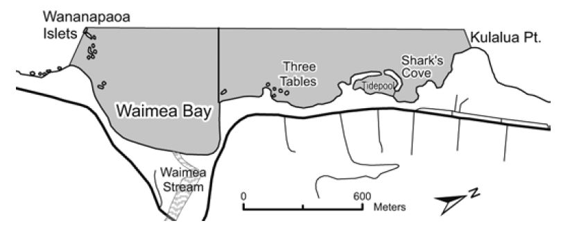
Pūpūkea Marine Life Conservation District
Location: The Pūpūkea Marine Life Conservation District is located on the northern coast of O‘ahu, from the highwater mark seaward, bounded by a line extending due west from Kulalua Point to a point 100 yards offshore, then south to the most seaward exposed rock of
Wananapaoa Islets on the south side of Waimea Bay (including the islets), then due southeast to shore, as shown.
Permitted
To take and possess up to two pounds (combined total, squeezed dry) of limu kohu and limu lipe‘epe‘e by hand harvest only, provided the limu's holdfast is left in place.
To possess a knife for personal safety only.
Within Waimea Bay only:
To take and possess any finfish with hook-and-line from shore, with not more than two poles per person and one line per pole with no more than two hooks per line.
To take with legal nets and possess ‘opelu during August and September, and akule during November and December.
Prohibited
To fish for, take, injure, kill, possess or remove any marine life (including eggs), except as indicated in permitted activities above.
To take or alter any geological feature or specimen.
To possess in the water any device that may be used to take marine life, or alter any geological feature or specimen.
To introduce any food or other substance into the water to attract marine life, except as permitted for fishing in Waimea Bay.
To snag any akule while fishing from the shore of Waimea Bay according to permitted activities above.
Warning: Hazardous to enter water during periods of high surf along the North Shore.
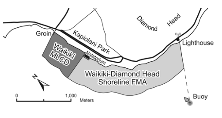
Waikīkī Marine Life Conservation District
Location: The Waikīkī Marine Life Conservation District extends from the groin at Kapahulu Avenue to the ewa wall of the Waikīkī War Memorial Natatorium, from the highwater mark out to a minimum seaward distance of 500 yards, or to the seaward edge of the fringing reef if one occurs beyond 500yards.
Permitted
To possess in the water any knife and any shark billy, bang stick, powerhead or carbon dioxide injector.
With a permit to engage in activities otherwise prohibited by law for scientific, propagation or other purposes.
Prohibited
To fish for, take or injure any marine life (including eggs), or possess in the water any device that may be used for the taking of marine life.
To take or alter any sand, coral or other geological feature or specimen, or possess in the water any device that may be used for the taking or altering of a geological feature or specimen.
Waikīkī-Diamond Head Shoreline Fisheries Management Area
Location: The Waikīkī-Diamond Head Shoreline Fisheries Management Area extends from the ‘Ewa wall of the Waikīkī War Memorial Natatorium to the Diamond Head Lighthouse, from the highwater mark out to a minimum seaward distance of 500 yards, or to the seaward edge of the fringing reef if one occurs beyond 500 yards.
Fishing periods
“Open to fishing” from January 1 to December 31 of even-numbered years.
“Closed to fishing” from January 1 to December 31 of odd-numbered years.
Permitted
To fish for, take or possess any legal size marine life in season during the“open to fishing” period, provided that only hook-and-line, thrownet, handnet to land hooked fish, and spear fishing and hand harvesting methods are employed.
With a permit to engage in activities otherwise prohibited by law for scientific, propagation or other purposes.
Prohibited
To fish for, take or injure any marine life (including eggs), or to possess in the water any fishing gear during the “closed to fishing” period.
To use any spear between the hours of 6:00 pm to 6:00 am, or have or possess in the water any trap or net except throw net or hand net to land hooked fish during the “open to fishing” period.
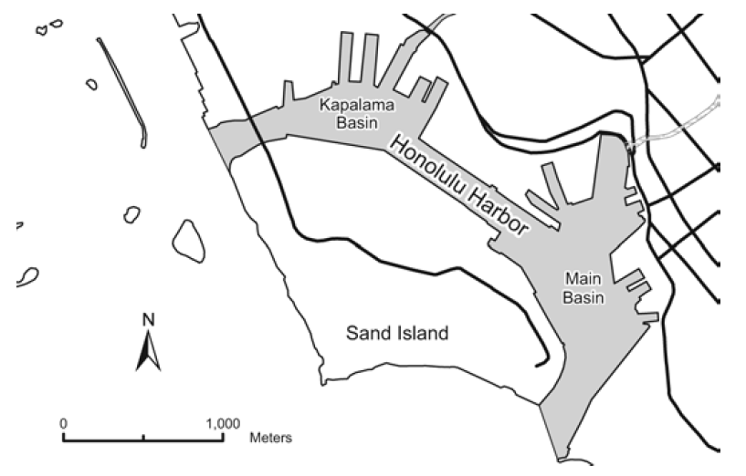
Honolulu Harbor
Location: Honolulu Harbor is the primary port on the southern coast of O‘ahu.
Permitted
Commercial Marine licensees with a Bait License may take baitfish during periods scheduled by the harbor master.
Prohibited
Unlawful to take fish by means of any draw, drag or seine net.
Note: All boaters must be in contact with the harbor controller (VHF Ch. 12) whenever operating in Honolulu Harbor.
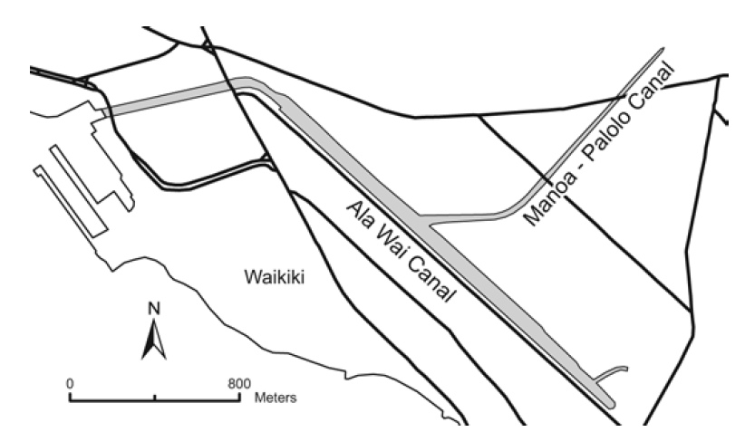
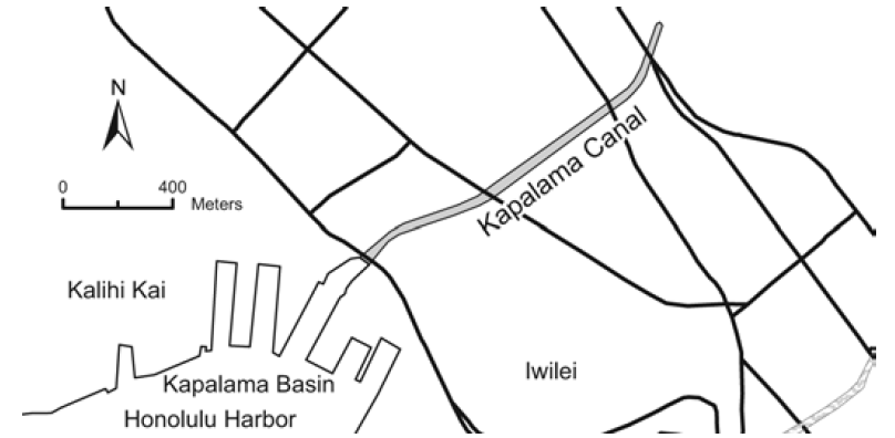
Ala Wai Canal, Kapālama Canal
Location: Ala Wai Canal is located immediately north of Waikīkī, and for the purposes described here includes the Manoa-Pālolo drainage canal at the mouth of Manoa and Pālolo Streams.
Kapālama Canal is located at the mouth of Kapālama Stream, north of Sand Island.
Permitted
To take any legal size fish in season with one line, or one rod and line, with no more than two hooks.
To take crabs with not more than 10 nets, provided the nets are not more than two feet in diameter.
To take shrimp for bait with a hand net, provided that the net is not more than three feet in any dimension.
Within the Ala Wai Canal only, take up to 50 “tabai” or mosquito fish, ‘o‘opu akupa, tilapia or a combination thereof per day for non-commercial purposes, with a single small mesh net, provided the net including the handle and any attachment is not more than three feet in any dimension.
Commercial Marine licensees with a Bait License may take baitfishes.
Licensed pond owners or operators may take young mullet (pua) or other small fish for stocking their fishpond.
Prohibited
To fish in or take aquatic life, except as indicated in permitted activities above.
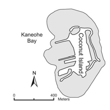
Coconut Island — Hawaii Marine Laboratory Refuge
Location: The Hawaii Marine Laboratory Refuge consists of the reefs and bay waters surrounding Coconut (Moku-o-Loe) Island located in Kāne‘ohe Bay, from the high water mark on the island seaward to twenty-five feet beyond the outer edges of the reefs.
Prohibited
Unlawful to take any aquatic life from within the boundaries of the refuge.
Exceptions
This restriction does not apply to any officer, faculty member, employee or student of the University of Hawai‘i, or licensee of the Board of Regents of the University of Hawai‘i while employed in catching or taking of aquatic life for scientific purposes. All authorized taking of aquatic life must follow minimum size and closed seasons for certain species, gear restrictions, etc.
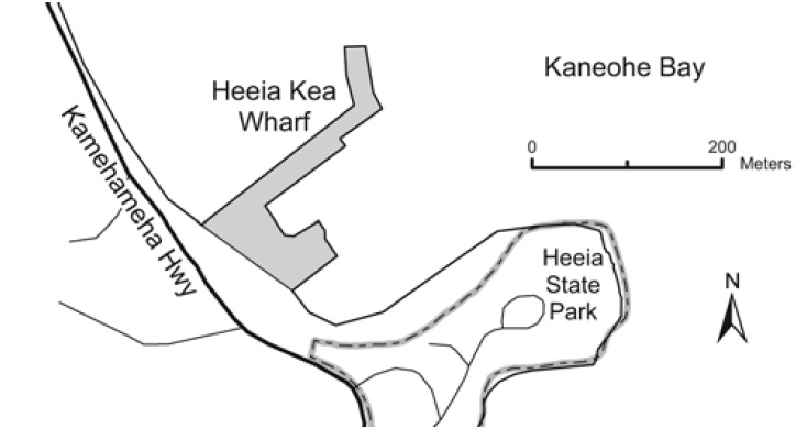
He‘eia Kea Wharf
Location: He‘eia Kea Wharf is located at He‘eia Kea Boat Harbor on Kāne‘ohe Bay, O‘ahu.
Permitted
To take any legal size fish in season with one line, or one rod and line, with no more than two hooks.
To take crabs with not more than 10 nets, provided the nets are not more than two feet in diameter.
To take shrimp for bait with a hand net, provided that the net is not more than three feet in any dimension.
Commercial Marine licensees with a Bait License may take baitfishes.
Licensed pond owners or operators may take young mullet (pua) or other small fish for stocking their fishpond.
Prohibited
To fish in or take aquatic life, except as indicated in permitted activities above.
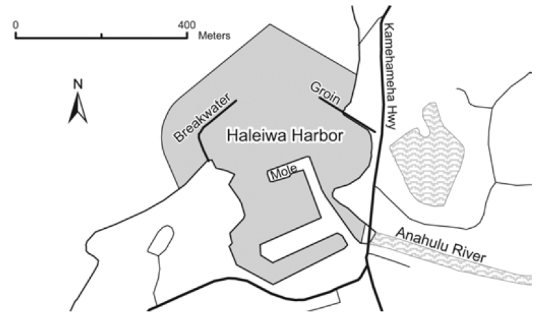
Waialua Bay (Hale‘iwa Harbor)
Location: That portion of Waialua Bay at Hale‘iwa bounded by lines drawn 100 yards seaward of and parallel to the Hale‘iwa Harbor Breakwater and 100 yards seaward of and parallel to the Hale‘iwa Beach Groin, and inland by a line ten yards downstream of and parallel to the Anahulu Bridge.
Permitted
To take any legal size fish in season with one line, or one rod and line, with no more than two hooks.
To take crabs with not more than 10 nets, provided the nets are not more than two feet in diameter.
To take shrimp for bait with a hand net, provided that the net is not more than three feet in any dimension.
Commercial Marine licensees with a Bait License may take baitfishes.
Licensed pond owners or operators may take young mullet (pua) or other small fish for stocking their fishpond.
Prohibited
To fish in or take aquatic life, except as indicated in permitted activities above.
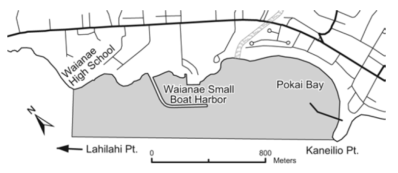
Pōka‘ī Bay
Location: That portion of Pōka‘ī Bay including the Pōka‘ī Boat Harbor and the Wai‘anae Small Boat Harbor, the seaward boundary a straight line from Kane‘ilio Point to Lahilahi Point, and the northwestern boundary a straight line extending southwest from the point immediately seaward of Wai‘anae High School.
Permitted
To take any legal size fish in season with one line, or one rod and line, with no more than two hooks.
To take crabs with not more than 10 nets, provided the nets are not more than two feet in diameter.
To take shrimp for bait with a hand net, provided that the net is not more than three feet in any dimension.
Commercial Marine licensees with a Bait License may take baitfishes.
Licensed pond owners or operators may take young mullet (pua) or other small fish for stocking their fishpond.
Prohibited
To fish in or take aquatic life, except as indicated in permitted activities above.
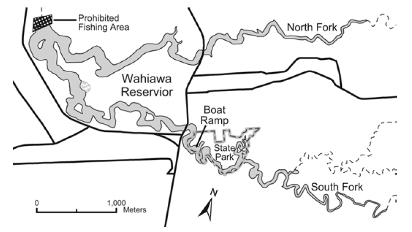
Wahiawā Public Fishing Area
Location: The Wahiawā Public Fishing Area includes a portion of the privately-owned Wahiawā Reservoir (Lake Wilson) in the central portion of O‘ahu. The Wahiawā State Freshwater Park is located along the South Fork of the Reservoir and includes a boat launching ramp and vehicle-trailer parking areas. The Park is a facility of the Division of State Parks. Rules of the State Parks System apply to the use of the facility.
Permitted
To fish with hook-and-line with not more than one lure or baited hook or two artificial flies attached to a single line, provided that on weekends and holidays only one line may be used, and on weekdays other than holidays two lines may be used.
To use attended traps and dip nets up to two feet long, wide, or high, excluding the handle, to land hooked fish or to take certain baitfishes, provided that tucunare, bass, channel catfish and oscar shall not be used as bait.
Prohibited
To enter into or fish without a valid Freshwater Game Fishing License and entry permit or other appropriate license or permit, and a USCG approved personal flotation device, and provided that all licensees or permittees under 15 years of age are accompanied by an adult.
To enter onto, fish from, or approach within 200 feet of the spillway dam and its shoreline, or to enter into or fish within the Forest Reserve along the NorthFork.
To swim, water ski, camp, picnic, build fires, dispose of refuse or pollute the waters, or damage public or private property.
To possess any firearms, air rifles or pistols, bows and arrows, spear, trotlines, nets other than dip nets, chemicals or other illegal fishing gear.
To snag any fish.
To operate a boat exceeding 18 feet in length, or for purposes other than fishing, or at speeds in excess of five miles per hour, or constructed of material other than wood unless provided with flotation to render the boat unsinkable.
Exceptions to size and bag limits
Bass and tucunare. Catch and release fishing only. Unlawful to keep, retain, hold, or kill any bass or tucunare. Bass or tucunare brought to shore or on board a vessel must be returned to the water immediately.
Oscar. Bag limit 1.
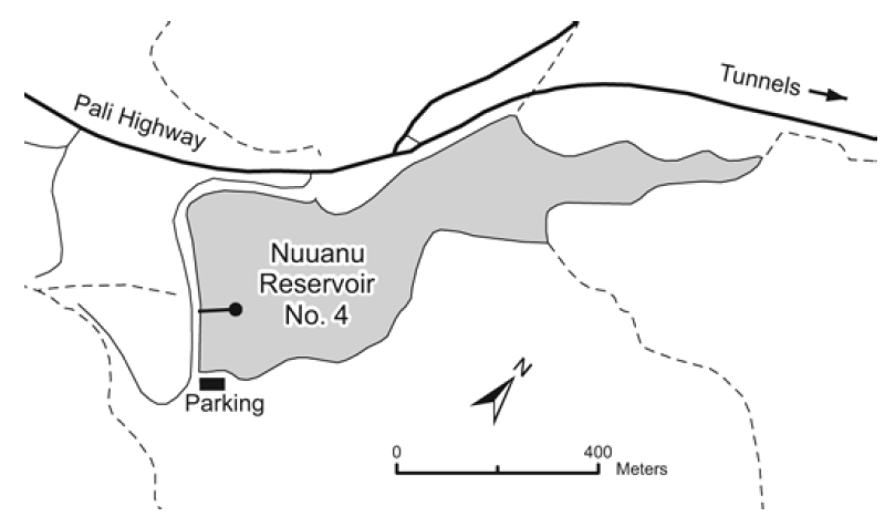
Nu‘uanu Freshwater Fish Refuge
Location: The Nu‘uanu Freshwater Fish Refuge includes the City and County of Honolulu’s Nu‘uanu Reservoirs No. 2, 3, and 4, located between Honolulu and Kailua off the Pali Highway on O‘ahu.
Prohibited
To enter into refuge unless accompanied by an agent of, or with a permit issued by the Board of Land and Natural Resources.
Nu‘uanu Reservoir No. 4 is now closed to fishing.
‘Ewa Limu Management Area
Location: The ‘Ewa Limu Management Area is located in the waters off ‘Ewa Beach on the south shore of O‘ahu, and extends from the western edge of the gunnery range to Mu‘umu‘u Place, from the shoreline 150 feet seaward.
Permitted
To hand-pick up to one pound of all types of limu combined per person per day from 6:00 am to 6:00 pm during the months of July, November, and December.
To exercise native Hawaiian gathering rights and traditional cultural practices as authorized by law.
Prohibited
To pick, gather, harvest or otherwise take limu except as described above without a permit.
HAWAI‘I
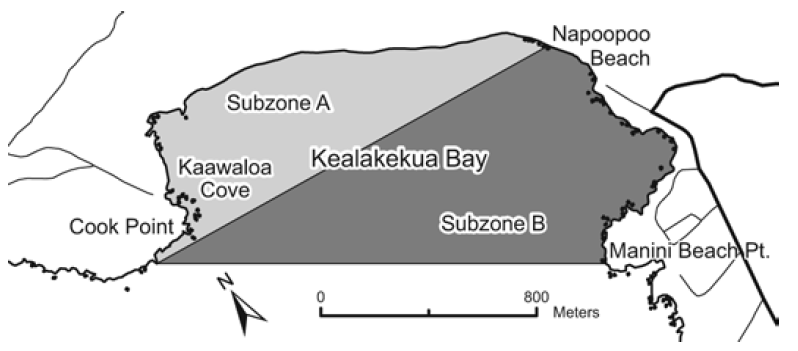
Kealakekua Bay Marine Life Conservation District
Location: The Kealakekua Bay Marine Life Conservation District is located offshore of the Kealakekua Bay Historical State Park on the western coast of the island of Hawai‘i, from the highwater mark seaward to a line from Cook Point to Manini Beach Point. A line from Cook Point to the north end of Nāpō‘opo‘o Beach divides the District into Subzone A to the north, and Subzone B to the south. The Division of Boating and Ocean Recreation has also established provisions relating to boating, anchoring and mooring within the Marine Life Conservation District.
Permitted
Within Subzone B only, to fish for, take or possess any finfish with or by the use of hook-and-line and thrownet, provided that any legal fishing device or method except traps may be used for the taking of akule, ‘opelu and crustaceans.
To possess in the water any knife and any shark billy, bang stick, powerhead or carbon dioxide injector.
With a permit to engage in activities otherwise prohibited by law for scientific, propagation or other purposes.
Prohibited
To fish for, take or injure marine life (including eggs), except as indicated in “Permitted” activities above.
To take or alter any sand, coral or other geological feature or specimen.
To engage or attempt to engage in fish feeding.
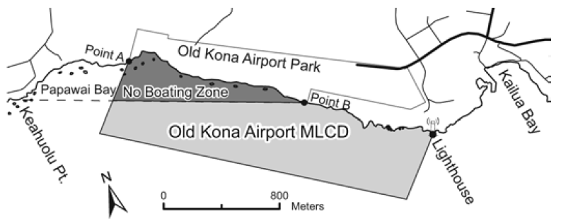
Old Kona Airport Marine Life Conservation District
Location: The Old Kona Airport Marine Life Conservation District (MLCD) includes (1) the waters offshore of the Old Kona Airport to the Kailua Lighthouse, bounded by a straight line from Point “A” seaward 500 yards, to a straight line from the Kailua Lighthouse seaward 500 yards; and (2) a “No Boating Zone” within the MLCD bounded by a straight line from Keahuolū Point to the southwestern corner of the private property at Point “B”.
Permitted
To fish for, take, possess or remove akule by handline at night, and ‘ōpelu by lift or ‘ōpelu net method using bait or chum for commercial or home consumption.
To fish for, take, possess or remove any finfish for home consumption by throw net or pole-and-line (without reel) with bait from shore.
To collect wana, wana halula, and hā‘uke‘uke with hand tool, and without use of scuba gear, from June 1 to October 1.
To use the state mooring not longer than three hours per boat each day on a first come, first served basis for non-commercial use.
Commercial dive/tour operations may be conducted at the mooring and from shore with a permit.
Prohibited
To fish for, take, injure, kill, possess or remove any marine life, including live sea shell and ‘opihi, live coral, algae or limu, or other marine life, or their eggs, except as indicated in permitted activities above.
To take or alter any sand, shell, coral, rock or other geological feature or specimen, or to possess in the water any device that may be used for the taking or altering of marine life, geological feature or specimen.
To feed or introduce any food material, substance or device as an attractant, directly to or in the vicinity of any aquatic organism except for the purpose of catching and removing that organism as permitted.
To anchor a water craft in the MLCD, or operate a motorboat or other motor powered water craft within the “No Boating Zone” except for emergency or enforcement purposes.
To conduct commercial dive/tour activities except as indicated in permitted activities above.
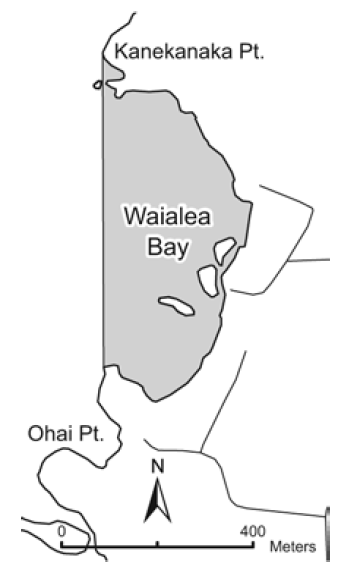
Waialea Bay Marine Life Conservation District
Location: The Waialea Bay Marine Life Conservation District is located offshore of Waialea Bay along the northwestern coast of the island of Hawai‘i, from the highwater mark seaward to a line from Kānekanaka Point to the point immediately north of ‘Ōhai Point.
Permitted
To have or possess any fishing pole and hook-and-line, and to fish for, take or possess any finfish using such gear.
To possess in the water any knife and any shark billy, bang stick, powerhead or carbon dioxide injector.
With a permit to possess and use legal nets to fish for, take or possess finfishes over the sandy bottom areas within the District, and to engage in activities otherwise prohibited by law for scientific, propagation or other purposes.
Prohibited
To fish for, take or injure any marine life (including eggs), or possess in the water any device that may be used for the taking of marine life, except as indicated in permitted activities above.
To take or alter any sand, coral or other geological feature or specimen, or possess in the water any device that may be used for the taking or altering of a geological feature or specimen.
To engage or attempt to engage in fish feeding.
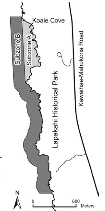
Lapakahi Marine Life Conservation District
Location: The Lapakahi Marine Life Conservation District encompasses Subzone A (Koai‘e Cove) and Subzone B, the adjacent shoreline area extending approximately 500 feet offshore of the Lapakahi State Historical Park on the northwestern coast of the island of Hawai‘i.
Permitted
Within Subzone B only, to fish for, take or possess any ‘ōpelu by lift or ‘ōpelu net, or any finfish or crustacean by hook-and-line or thrownet.
To possess in the water any knife and any shark billy, bang stick, powerhead or carbon dioxide injector.
With a permit to engage in activities otherwise prohibited by law for scientific, propagation or other purposes.
Prohibited
To fish for, take or injure any marine life (including eggs), or possess in the water any device that may be used for the taking of marine life.
To take or alter any sand, coral or other geological feature or specimen, or possess in the water any device that may be used for the taking or altering of a geological feature or specimen.
To engage or attempt to engage in fish feeding.
Hilo Bay, Wailoa River, and Wailuku River
Location: “Hilo Harbor” refers to that portion of the bay in Hilo bounded seaward by the breakwater, and a line from the tip of the breakwater southwestward to Āle‘ale‘a Point. “Wailoa River” is that part of Wailoa River bounded by a line drawn across the mouth of the river and the footbridge at the mouth of Waiākea Pond, and includes Waiolama Canal upstream to the highest wash of the tidal water. “Wailuku River” is that part of Wailuku River between the Māmalahoa Highway bridge and Wainaku Avenue bridge.
Permitted
Use of throw nets, ‘opae nets not exceeding three feet in any dimension, and nehu nets not longer than fifty feet to take nehu for family consumption or bait purposes.
Taking of crabs with baited lines, provided that a dip net may be used to land crabs lured to the bait, or with not more than five crab nets not exceeding two feet in longest straight line dimension and stretched mesh of not less than two inches, provided such nets are attended to at all times.
Commercial Marine licensees with a Bait License may take baitfishes.
Licensed pond owners or operators may take young mullet (pua) or other small fish for stocking their fishpond, except in Wailoa River.
Prohibited
To take or possess any aquatic life in violation of a season, minimum size, or other law, except pua as indicated above.
Use of nets, except as indicated in permitted activities above.
To take or possess more than 20 fish of mullet, moi, and all species of ulua (including pāpio and ‘omilu), provided such bag limit shall not include more than15 moi or 10 mullet per day.
To fish with more than two poles with one line each, or two handlines, or with more than two hooks or lures per line.
To use traps.
To spear any crab, or take or possess any crab with external eggs or with missing or mutilated abdomen or tail, or with a puncture wound.
To take or possess more than three Samoan crabs per day
To snag any fish.
To use or possess a throw net or spear in Wailoa River.
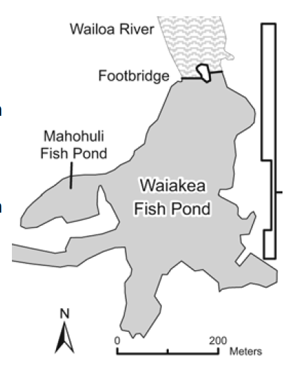
Waiākea Public Fishing Area
Location: The Waiākea Public Fishing Area includes that portion of the Waiākea fish pond in the Wailoa River State Park in Hilo, south of the footbridge over Wailoa River, including the flood control channel and Mahohuli fish pond. A boat launching ramp is located within the park. Rules of the state parks system also apply to the use of the facility.
Permitted
To fish with not more than one line and one lure, or two single hooks in tandem no more than two inches apart.
To use a dip net not exceeding 18 inches in diameter to land crabs lured to baited lines or to catch shrimp for bait purposes.
To fish for, take or possess an overall total of 20 fishes that include āholehole, ulua (including pāpio) and mullet, provided mullet shall not comprise more than ten fishes.
With a valid Freshwater Game Fishing License, to fish for, take or possess any introduced freshwater game fishes.
Prohibited
To operate boats for purposes other than fishing; to use boats constructed of material other than wood unless provided with flotation to render the boat unsinkable; for any juvenile under 13 years old to operate any boat unless accompanied by an adult 18 years of age or older; to propel any boat with a fossil fuel motor; to operate any boat between 7:30 pm and 6:30 am; or to operate a boat at any time without a life preserver for each occupant.
To permanently moor any boat.
To swim, water ski or engage in any other activity requiring immersion.
To snag any fish.
To enter into or fish in any area posted as fishing reserves or prohibited fishing zones.
To fish for mullet during the closed season.
To take or possess more than 3 Samoan crabs per day, or any Samoan crab less than 6 inches in width.
To possess or use a spear.
West Hawai‘i Regional Fishery Management Area
Location: The West Hawai‘i Regional Fishery Management Area (FRA) extends along the west coast of the Island of Hawaii from Ka Lae, Ka‘ū (South Point) to ‘Ūpolu Point, North Kohala, and from the highwater mark on shore seaward to the limit of the State's management authority. It includes the Fish Replenishment Areas, Netting Restricted Areas, and Marine Reserve depicted in the accompanying maps and described fully in the administrative rule (available at DAR offices and web site), as well as all other Marine Life Conservation Districts and Fisheries Management Areas along the West Hawai‘i shoreline.
Permitted
All types of fishing, except as indicated in prohibited activities below.
Prohibited within the West Hawaii Regional FMA
To take, kill, possess, sell, or offer for sale, any specimen of the following: Hawaiian stingray, broad stingray, pelagic stingray, spotted eagle ray, blacktip reef shark, gray reef shark, whitetip reef shark, tiger shark, whale shark, horned helmet, and Triton's trumpet. See administrative rule (available at DAR offices and web site) for species list.
To possess more than five yellow tang larger than 4.5 inches total length, or more than five yellow tang smaller than 2 inches total length
To engage in SCUBA spearfishing, possess both SCUBA gear and a spear at the same time, or possess SCUBA gear and any specimen of speared aquatic life at the same time.
To possess aquarium collecting gear, or take or possess any specimen of aquatic life for aquarium purposes between sunset and sunrise, without a valid aquarium permit or in violation of its conditions, or while on a vessel that does not conform to registration requirements.
To possess or use any net or container underwater to capture or hold aquatic life alive for aquarium purposes, which is not labeled with the commercial marine license number(s) of the person(s) owning, possessing, or using the equipment.
Prohibited in selected areas
Fish feeding within any of the Fish Replenishment Areas (FRA), Netting Restricted Areas (NRA), Marine Reserve, or any other West Hawaii Regional managed area.
While within any Fish Replenishment Area, Marine Life Conservation District, or Fisheries Management Area (other than Kiholo Bay FMA):
To collect aquatic life for aquarium purposes.
To possess aquarium collecting gear, or take or possess any aquatic life for aquarium purposes, except aboard a vessel in active transit through those areas, provided no collecting gear is in the water during transit. Boats adrift, anchored, or moored are not considered to be in transit.
Lay net fishing within the following Fish Replenishment Areas (FRA) and Netting Restricted Areas (NRA) is prohibited: Puakō-‘Anae-ho‘omalu FRA, Kikaua Point-Mākole‘a NRA (Kekaha Kai State Park); Nenue Point (Red Hill FRA)-Kealakekua Bay NRA, Hanamalo Point-Kānewa‘a Point NRA, Kanonohe-Kalīpoa NRA, Kaloko-Honokōhau FRA. Exception: lay net fishing is allowed in Kaloko-Honokōhau FRA using a locally constructed, handmade lay net of natural fibers, which is registered and used in accordance with other lay net restrictions (below).
Prohibited in Ka‘ūpūlehu Marine Reserve
To take any aquatic life, except the following may be taken seaward of the 20-fathom depth contour: ‘ōpakapaka, kalekale, lehi, gindai, onaga, ehu,hāpu‘upu‘u, uku, ta‘ape, roi, toau, nabeta, aku, ahi and tombo, a‘u, ono, and mahimahi by hook-and-line; also Kona crab by Kona crab net. See administrative rule for species names.
To possess any marine life except as indicated above.
Possess or use any fishing gear other than hook-and-line and/or Kona crab net.
Deploy any fishing gear shoreward of the 20 fathom depth contour.
Lay nets
Possession or use of the following is prohibited:
A lay net not registered with DLNR.
More than one lay net per person.
Lay nets exceeding 125 feet in length or seven feet in stretched height; with stretched mesh less than 2-3/4 inches (three inches in Kailua Bay FMA); two or more nets joined for combined total length exceeding 250 feet.
Multi-panel nets.
A lay net without at least four identification tags as specified by DLNR; tags must be attached at each end of float and lead lines.
Lay net fishing
The following is prohibited:
Use of a lay net not marked by buoys as specified.
Use of a lay net within 1,200 feet of another lay net (except two joined nets).
Use of a lay net in water more than 80 feet deep.
Use of a lay net for more than four hours during one set, or within 24 hours after the end of a set, or to set another lay net within 24 hours.
To leave a lay net unattended for more than 1/2 hour
Retrieval in a manner that causes coral breakage from its attachment or into smaller pieces.
Failure to inspect entire net within two hours after beginning of set.
To discard or leave any lay net or portion thereof in the water longer than four hours.
To falsely identify a lay net.
Persons using a vessel or float may use a total maximum of 250 feet of lay net, provided that at least two people are present and associated with the same vessel or float.
If a registered lay net is no longer in the possession of the registered owner, the owner is responsible for the lay net until a report is filed and confirmed by DLNR.
Further details regarding lay net fishing can be obtained from DAR at time of registration.
Aquarium collecting permits and vessel registration
A West Hawaii aquarium permit is required to engage in aquarium collecting activities.
Holders of an aquarium permit may only take certain species, and there are daily bag limits for achilles tang and certain sized kole. A copy of the "white list" and other restrictions may be obtained at the Kona DAR office or by downloading the administrative rule.
All aquarium-fishing vessels shall:
Be registered yearly with DLNR to take marine life for that purpose.
Permanently display the letters "AQ" on both sides as specified by rule.
Fly a stiffened flag or pennant with the letter "A" as specified.
Display a dive flag when divers are in the water.
In the event an aquarium collecting vessel becomes inoperable, the operator shall immediately notify DOCARE or the United States Coast Guard by VHF radioand/or cellular phone.
Further details regarding aquarium collecting can be obtained from DAR at time of registration.
Site descriptions and boundaries can be obtained from the administrative rule, available at DAR offices and web site.
Kona Coast
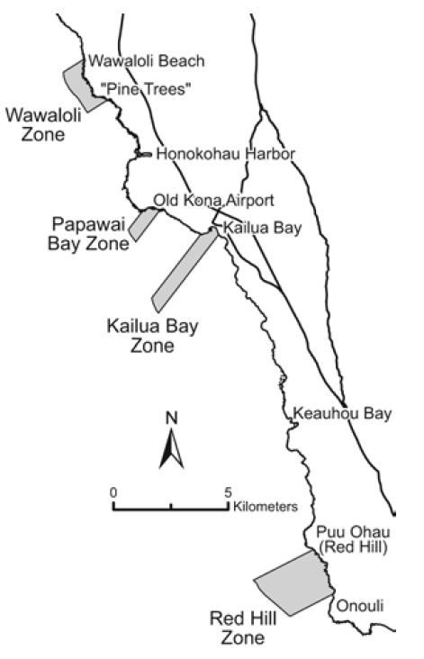
Location: “Kona Coast” refers to the following four Fisheries Management Area Zones on the southwestern portion of Hawai‘i, each bounded by two lines extending seaward at right angles from shore and marked by signs on shore:
(a) the “Wawāloli Zone”, from south of Wawāloli Beach to south of Wāwahiwa‘a Point; (b) the “Papawai Bay Zone”, from Keahuolu Point to the northwestern end of the runway of the Old Kona Airport; (c) the “Kailua Bay Zone”, from Kukailimoku Point near the Kailua lighthouse, to the former swimming pool at the Kona Inn Shopping Village; and (d) the “Red Hill Zone”, from Pu‘u Ōhau (“Red Hill”) to Onouli. The seaward boundary is at a depth of 100 fathoms (600 ft).
Permitted
To catch fish in the Zones with legal fishing gear for personal consumption.
Prohibited
To collect any aquarium fish within the Zones.
To engage in fish feeding within the Zones, except for ‘ōpelu fishing.
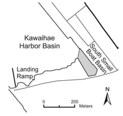
Kawaihae Harbor
Location: Kawaihae Harbor is located at Kawaihae, South Kohala, on the northwest coast of the island of Hawai‘i. Restrictions apply to the south small boat basin as indicated in the map at right.
Permitted
To take any legal size fish in season with not more than two lines, or two poles or rods and lines.
To use hand nets not exceeding three feet in any dimension to take shrimp or nehu for bait purposes, or to land fish already hooked.
Prohibited
To snag or attempt to snag any fish.
To use any type of net, except handnets as indicated in permitted activities above.
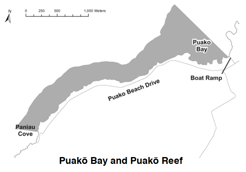
Puakō Bay and Puakō Reef
Location: The Puakō Bay and Puakō Reef Fisheries Management Area includes that portion of the reef from the shoreline at the western most edge of the boat ramp, along a line drawn parallel with the ramp seaward to the edge of the fringing reef north of Puakō Point, then southwesterly following the fringing reef a minimum seaward distance of 250 yards or to the edge of the fringing reef if one occurs beyond 250 yards, to a line due west of the small cove at the southern end of Puakō Beach Road.
Permitted
To possess aboard any boat or watercraft any legal fishing gear and any fish or other aquatic life taken outside of the area.
With a permit to engage in activities otherwise prohibited by law for scientific, propagation or other purposes.
Prohibited
To possess or use any type of net except thrownet.
To engage or attempt to engage in fish feeding.
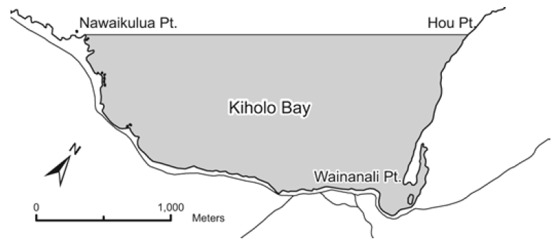
Kiholo Bay
Location: The Kiholo Bay Fisheries Management Area includes that part of Kiholo Bay enclosed by a straight line drawn from Nāwaikūlua Point to Hou Point as shown, including the lagoon known as Wainānāli‘i Pond, but not Luahinewai Pond.
Permitted
Aquarium fish permittees may use small-meshed nets other than thrownets, provided the person is within visual range of the net at all times.
Prohibited
To possess gill nets within the Fisheries Management Area.
To engage or attempt to engage in fish feeding.
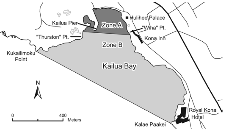
Kailua Bay
Location: The Kailua Bay Fisheries Management Area includes that portion of Kailua Bay enclosed by a straight line drawn from Kukailimoku Point to the seawall of the Royal Kona Resort. A line from the northern edge of the channel at “Thurston Point” to the corner (“Wīha Point”) south of Hulihe‘e Palace and north of the former Kona Inn Hotel separates “Zone A” in the northwestern portion of the FMA from the seaward “Zone B”, as shown.
Permitted
To take any legal size fish in season with not more than two lines, or two rods and lines, and with not more than two hooks each.
To take crabs with not more than 10 nets, provided the nets are not more than two feet in diameter.
To take shrimp for bait with a hand net, provided that the net is not more than three feet in any dimension.
To possess any spear or thrownet while transiting Zone A.
Within Zone B only, to use nets of mesh size not less than 3 inches to take fish, or akule net to take akule only, provided that nets shall not be in the water between sunset and sunrise, or remain in the water except during active retrieval or unloading of fish from that net.
Within Zone B only, to use spears or thrownets.
Commercial Marine licensees with a Bait License may take baitfishes.
Licensed pond owners or operators may take young mullet (pua) or other small fish for stocking their fishpond.
Prohibited
To snag or attempt to snag any fish.
To herd, chase or pa‘ipa‘i fish out of Zone A by swimming, diving or from a boat, which results in fish being taken by net.
To otherwise fish for or take aquatic life, except as indicated in permitted activities above.
To engage or attempt to engage in fish feeding.
Keauhou Bay
Location: The Keauhou Bay Fisheries Management Area is that portion of the bay bounded by a straight line drawn from Haiku'ua Point to Kaukala‘ela‘ePoint.
Permitted
To take any legal size fish in season with not more than two lines at the same time.
To use hand nets not exceeding three feet in any dimension to take shrimp for bait purposes only, or to land fish already hooked.
To use thrownets in the zone bounded by a straight line from “Doc Hill” to the north end stairs in the wall fronting the volleyball court, as shown in the map above.
Prohibited
To snag or attempt to snag any fish.
To use or possess nets, except as indicated in permitted activities above.
To herd or chase any fish out of the area by swimming, diving or using a boat.
To engage or attempt to engage in fish feeding.
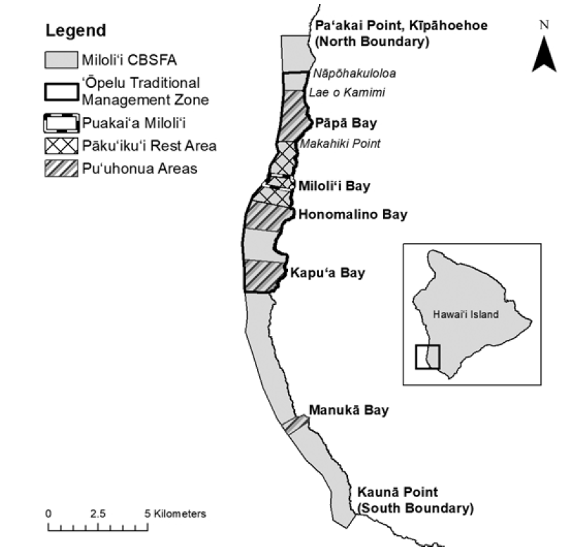
Miloli‘i Community-Based Subsistence Fishing Area
Location: The Miloli‘i Community-Based Subsistence Fishing Area (CBSFA) includes the waters and submerged lands from the shoreline to the 100-fathom depth contour on the southwest coast of Hawai‘i Island, from Pa‘akai Point at Kīpāhoehoe in the north to Kaunā Point in the south and contains numerous sub-zones, as shown. GPS coordinates can be found on the DAR website on the administrative rules page in Part II, Chapter 60.10.
Sub-zones and their shoreline boundaries:
‘Ōpelu Traditional Management Zone:
From Nāpōhakuloloa (“2-Stone”) in the north to Kāki‘o Point (Kaupō) in the south.
Pu‘uhonua Pāpā:
From Lae o Kamimi in Pāpā Bay in the north to Makahiki Point in the south.
Pāku‘iku‘i Rest Area:
From Makahiki Point in the north to Kapulau (Honomalino Point) in the south.
Puakai‘a Miloli‘i:
From Kapukawa‘aiki (Miloli‘i Lighthouse) in the north to Lae Loa in the south.
Pu‘uhonua Honomalino:
From Kapulau (Honomalino Point) in the north to Pūke‘oke‘o (Pōhaku Ke‘oke‘o) in the south.
Pu‘uhonua Kapu‘a:
From Kalapili (Okoe Bay) in the north to Kāki‘o Point (Kaupō) in the south.
Pu‘uhonua Manukā:
From Kamoi Point (north point of Manukā Bay) in the north to the south point of Manukā Bay.
Permitted:
To possess prohibited gear and restricted species while onboard a vessel in active transit through the area, provided no prohibited gear is in the water.
To fish outside the four Pu‘uhonua except as indicated in prohibited activities below.
Within the four Pu‘uhonua:
To fish from shore using throw net, scoop net, and hook-and-line;
To fish from a vessel using hook-and-line;
To fish using a pole spear;
To fish for akule using legal nets.
Prohibited:
Aquarium fishing.
To take or possess female ‘a‘ama crab with eggs.
To take or possess kole during the months of March through June. From July through February the bag limit for kole is 20 per person per day, and minimum size is five inches.
To take or possess ‘opihi kō‘ele.
To take or possess more ‘opihi makaiauli and ‘opihi ‘ālinalina (with shell) than can fit in a one-gallon size bag per person per day.
To take or possess pāku‘iku‘i before July 1, 2027. Beginning July 1, 2027 pāku‘iku‘i bag limit is five per person per day, and minimum size is five inches.
To spear uhu at night using any gear type.
To take or possess uhu ‘ele‘ele or uhu uliuli.
To take or possess uhu ‘ahu‘ula or uhu pālukaluka during the months of March through May. From June through February the minimum size for these species is 14 inches and maximum size is 20 inches, and the bag limit is one fish per person per day.
To take or possess more than three other uhu per person per day; only one may be a terminal-phase uhu.
To take or possess more than two ula per person per day.
To take or possess any ‘ū‘ū from April through June.
Prohibited within selected areas:
‘Ōpelu Traditional Management Zone:
To take any ‘ōpelu except by hook-and-line from February through August.
The four Pu‘uhonua:
To harvest any ‘opihi;
To fish using any gear or method other than indicated in “Permitted” activities above.
Pāku‘iku‘i Rest Area:
To take or possess any pāku‘iku‘i. Puakai‘a Miloli‘i:
To use or possess any spear except pole spear;
To spear any uhu, pāku‘iku‘i, weke ‘ula, moano kea, or ‘ū‘ū;
To use a lay net at night.
Scientific names of regulated species
‘A‘ama crab - Grapsus tenuicrustatus
‘Opihi ‘ālinalina - Cellana sandwicensis
‘Opihi kō‘ele - C. talcosa
‘Opihi makaiauli - C. exarata
‘Ū‘ū - genus Myripristis
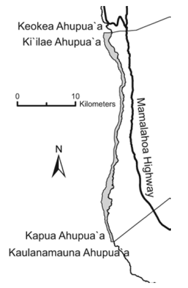
South Kona (Miloli‘i)
Location: The waters off the coast of South Kona between the Ki‘ilae-Kēōkea boundary and the Kapua-Kaulanamauna boundary.
Prohibited
l To fish for or take ‘ōpelu with fish or animal bait, except with hook and line.
KAUA‘I
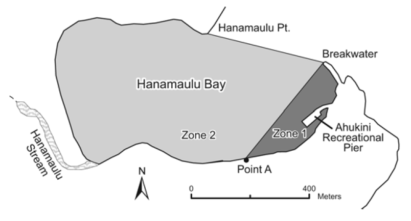
Hanamā‘ulu Bay and Ahukini Recreational Pier
Location: The regulated region of the Hanamā‘ulu Bay Fisheries Management Area is that portion of the bay, from the highwater mark seaward, bounded by a straight line from the tip of the breakwater westward to point "A," as shown. The Ahukini recreational pier is a public fishing pier, and a facility of the Division of State Parks. Rules of the State Park system also apply to use of the facility.
Prohibited
To swim in Zone 1.
To use any draw, drag, seine, or other type of net except thrownet, crab net, or landing net not more than 3 feet in any dimension, excluding handle in Zone1.
To take or possess more than 75 akule or more than 5 mullet per person per day in Zone 1.
To use any thrownet or spear within 50 yards of the Ahukini recreational pier, or from the adjoining pier frame.
To snag any fish or possess any thrownet while on the Ahukini recreational pier.
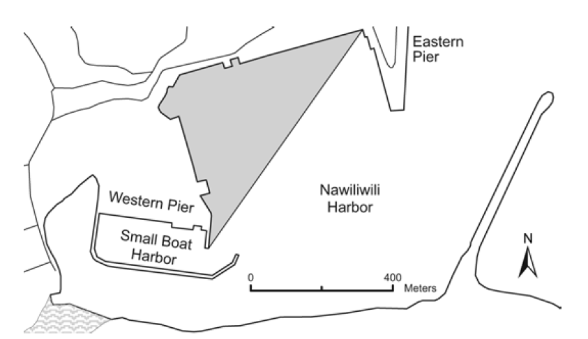
Nāwiliwili Harbor
Location: The regulated region of the Nāwiliwili Harbor Fisheries Management Area is that portion of the harbor, from the highwater mark seaward, bounded by a straight line from the southernmost tip of the western pier northeast to the corner formed where pier 1 meets the eastern pier, as shown.
Prohibited
To use any net, except a landing net not more than 3 feet in any dimension, excluding handle.
To snag any fish.
To take or possess more than 75 akule per person per day.
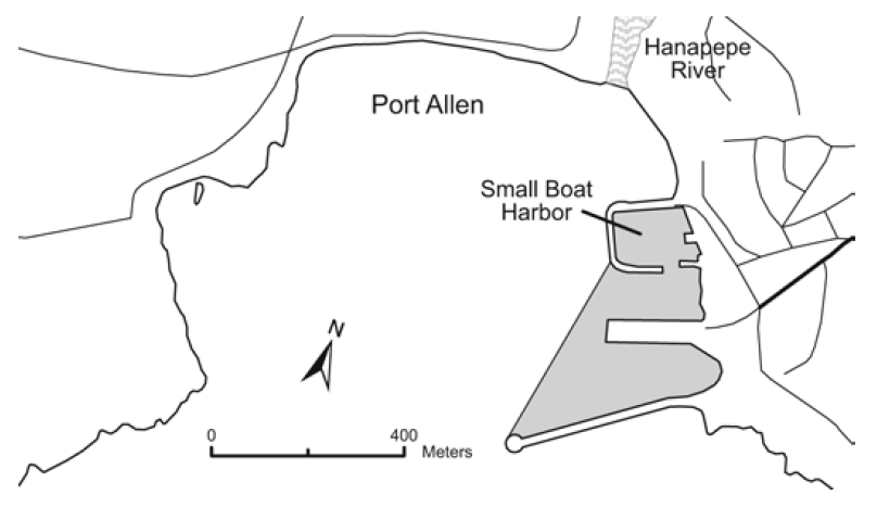
Port Allen
Location: The regulated region of the Port Allen Fisheries Management Area is that portion of the Port Allen waters, from the highwater mark seaward, bounded by a straight line from the tip of the main breakwater northward to the bend in the breakwater of the small boat harbor, as shown.
Prohibited
To use any net, except a landing net not more than 3 feet in any dimension, excluding handle.
To snag any fish.
To take or possess more than 75 akule per person per day.
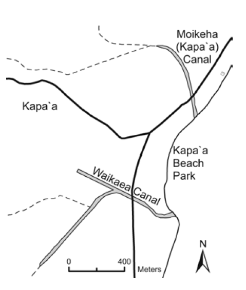
Kapa‘a and Waika‘ea Canals
Location: Kapa‘a and Waika‘ea Canals are located in the city of Kapa‘a on the east coast of Kaua‘i.
Permitted
To take any legal size fish in season with one line, or one rod and line, with no more than two hooks.
To take crabs with not more than 10 nets, provided the nets are not more than two feet in diameter.
To take shrimp for bait with a hand net, provided that the net is not more than three feet in any dimension.
Commercial Marine licensees with a Bait License may take baitfishes.
Licensed pond owners or operators may take young mullet (pua) or other small fish for stocking their fishpond.
Prohibited
To fish for or take aquatic life, except as indicated in permitted activities above.
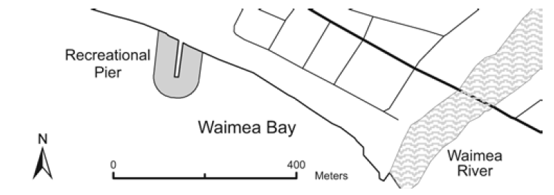
Waimea Bay and Waimea Recreational Pier
Location: Waimea Recreational Pier is a public fishing pier located in Waimea Bay on the southern coast of Kaua‘i. The Waimea Recreational Pier is a facility of the Division of State Parks. Rules of the State Park System also apply to the use of the facility.
Prohibited
Within 50 yards of the Waimea Recreational Pier, to use any spear, trap or any type of net except crab net.
While on Waimea Recreational Pier, to
possess more than two fishing poles with one line each, or fish with more than two fishing lines, or leave any unattended fishing line in the water;
possess any thrownet;
reserve or occupy any space between the marks other than the one space personally occupied for fishing; or
fish from any space between the marks already occupied by a fisherman.
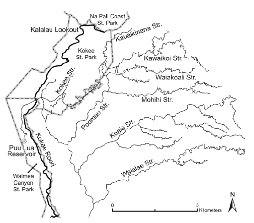
Kōke‘e Public Fishing Area
Location: The Kōke‘e Public Fishing Area includes certain streams, reservoirs and ditches in the Kōke‘e State Park on Kaua‘i.
Permitted
During an open season as announced by the Department on or about January 1 each year, and with a valid Freshwater Game Fishing License, to fish for, possess, or remove rainbow trout with one pole and line, or one line using one baited hook attached to the single line.
To fish only during a daily time period as determined by the Department for that open season.
To use a dip net up to two feet in longest axis, excluding the handle, to land hooked trout.
To take up to the maximum number of trout per licensee per day during the open season as determined by the Department for that season.
All anglers must report before and after fishing activities at designated checking stations, and must allow inspection of any bag, container, vehicle, or conveyance used to carry or transport aquatic life.
Prohibited
To fish for, take or possess any rainbow trout except as described in permitted activities above.
To use any form of corn for bait.
To use treble hooks or more than one hook.
To possess spears, chemicals, trotlines, nets (except as indicated in permitted activities above) or other illegal fishing gear.
To enter into or fish in the prohibited fishing zone along a portion of Kōke‘e Stream and its tributaries above Camp Sloggett, or any other area which may be posted as a prohibited fishing zone.
To damage or mutilate any private or public property, or contaminate or pollute any stream, ditch, spring, water hole or reservoir.
To operate any vehicle in any fishing area except on roads for vehicular use, or use any aircraft to gain access for fishing purposes.
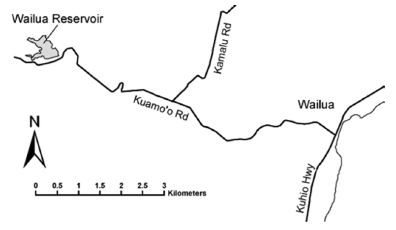
Wailua Reservoir Public Fishing Area
Location: The Wailua Reservoir Public Fishing Area is located off Kuamo‘o Road approximately five miles mauka of Kūhi‘ō Hwy, above the city of Wailua on Kaua‘i.
Permitted
With a valid Freshwater Game Fishing License, to fish using one pole and line, or one line with one lure or baited hook attached to the single line.
To use a dip net up to two feet in longest axis, excluding the handle, to land hooked fish.
To take up to an aggregate total of three fish per licensee per day, provided that fishers must allow inspection of any bag or container, or any vehicle or other conveyance used to carry or transport aquatic life.
To fish only during the day (no night fishing).
Prohibited
l To fish for, take or possess any fish except as described in permitted activities above.
l To possess spears, chemicals, trotlines, or nets, except as indicated in permitted activities above.
l To snag any fish.
l To possess or use any live animal or plant as bait.
l To enter into or fish from any irrigation infrastructure, including catwalks, valve towers, or ditches.
l To launch or use any vessel or floatable object, motorized, non-motorized, or wind-powered, on the reservoir.
l To swim, bathe, or conduct any activity in the reservoir other than fishing.
l To enter into or fish for any aquatic life at any portion of the reservoir designated as a wildlife or waterbird sanctuary.
l To contaminate or pollute the reservoir, ditch, or stream.
Bag and size limits
Bluegill. Bag limit 2, minimum size 7 inches total length (TL).
Smallmouth bass. Bag limit 2, minimum size 9 inches TL.
Largemouth bass. Bag limit 2, minimum size 9 inches TL, maximum size 14 inches TL.
Tucunare. Bag limit 2, minimum size 12 inches TL, maximum size 15 inches TL.
Note: bag limits are listed for individual species. The aggregate total bag limit of three fish applies.
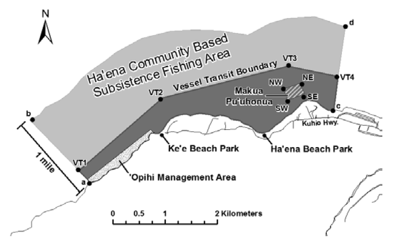
Hā‘ena Community-Based Subsistence Fishing Area
Location: The Hā‘ena Community-Based Subsistence Fishing Area (CBSFA) includes the waters and submerged lands from the shoreline to a distance of one mile off the northwestern coast of Kaua‘i, bounded by a straight line extending seaward at the boundary between Hā‘ena State Park and Nā Pali State Park, and a straight line extending seaward at the boundary between Hā‘ena and Wainiha, as shown.
Permitted
Pole spears 8 feet or less.
Up to two fishing poles per person, with no more than two hooks per line.
Throw nets.
Pa‘ipa‘i net or surround gill net fishing methods, as long as the nets are deployed from shore or from a vessel less than 14 feet long. Two people must be within five feet of the net at all times while it is deployed.
Scoop nets, but may not be used at night (between 6:00 pm and 6:00 am). Limit of three specimens of marine life may be taken with scoop net per day.
Taking of limu by hand harvest only.
Vessels with prohibited gear onboard may transit through the CBSFA as long as they remain outside the Vessel Transit Boundary (see boundaries below).
Prohibited
Fish feeding.
Taking of live shells.
Taking of live or empty shells while using SCUBA.
Spear guns.
Spearing at night (between 6:00 pm and 6:00 am).
Lay nets.
Selling or offering for sale any marine life taken from within the area.
Possession of prohibited fishing gear, except outside the Vessel Transit Boundary.
Taking, altering, defacing, destroying, possessing, or removing any sand, coral, rock, or other geological feature or specimen.
Bag limits
‘Opihi, pipipi, kūpe‘e, and pūpū: limit of 20 total combined per day from the ‘Opihi Management Area only.
Lobster: limit of two per day, hand harvest only
Urchins: limit of five per species per day.
He‘e: limit of two per day; may be taken only by hand harvest or with a stick no more than two feet in length.
Regulated areas
‘Opihi Management Area
Waters and submerged lands from the shoreline to a distance of 300 feet, from the Hā‘ena/Nā Pali boundary of the CBSFA to a line extending seaward at the western edge of Ke‘e Beach, as shown.
Only place where ‘opihi, pipipi, kūpe‘e, and pūpū may be harvested, beginning December 1, 2017.
Makua Pu‘uhonua
Waters and submerged lands of Makua lagoon; a four-sided area bounded by straight lines between the points as shown, with the following coordinates.
SW: 22o13'33.88" N, 159o33'42.41" W
NW: 22o13'41.15" N, 159o33'44.67" W
NE: 22o13'44.57" N, 159o33'34.71" W
SE: 22o13'38.26" N, 159o33'31.56" W
No entry without a special activity permit (applies to vessels and individuals).
Vessel Transit Boundary
Waters and submerged lands bounded by a line drawn along the CBSFA boundary from the shoreline between Hā‘ena State Park and Nā Pali State Park (Point "a") at 22o12'42.50" N, 159o35'44.50" W to a point 1,000 feet offshore at 22o12'49.98" N, 159o35'51.79" W (VT1), eastward to a point 1,300 feet offshore at 22o13'35.57" N, 159o34'59.73" W (VT2), then to a point 2,300 feet offshore at 22o13'55.42" N, 159o33'42.00" W (VT3), then to a point 2,100 feet offshore at 22o13'48.84" N, 159o33'10.76" W (VT4), then along the CBSFA boundary to a point on the shoreline between Hā‘ena and Wainiha (c) at 22o13'28.00" N, 159o33'13.50" W, as shown.
Allows vessels with prohibited gear onboard to transit through the CBSFA as long as they remain outside the Vessel Transit Boundary. This boundary does not affect general vessel operation or access to any area.
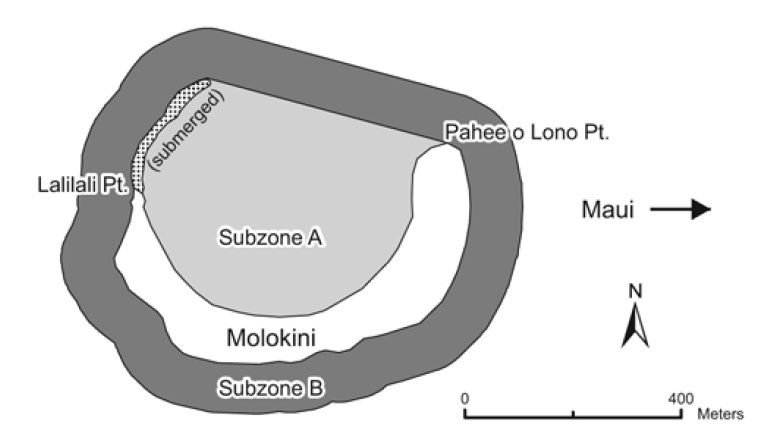
Location: The Molokini Shoal Marine Life Conservation District is located offshore of Molokini Shoal, about three miles from the southwestern coast of Maui. "Subzone A" includes the waters and submerged lands within the crater bounded seaward by a straight line from the end of the submerged ridge extending off Lalilali Point to Pahe‘e O Lono Point. "Subzone B" includes the waters and submerged lands 100 yards seaward of Molokini Shoal and Subzone A as shown.
Permitted
To fish for, take or possess finfish by trolling in Subzone B only.
To possess in the water any knife and any shark billy, bang stick, powerhead or carbon dioxide injector.
With a permit to engage in activities otherwise prohibited by law for scientific, propagation or other purposes.
To engage in commercial activities, excluding the taking of marine life, with a permit.
Prohibited
To fish for, take or injure any marine life (including eggs), or possess in the water any device that may be used for the taking of marine life, except as indicated in permitted activities above.
To take or alter any sand, coral or other geological feature or specimen, or possess in the water any device that may be used for the taking or altering of a geological feature or specimen.
To feed or deliberately introduce any food material, substance or attractant directly to or in the vicinity of any aquatic organism by any means or for any purpose except for trolling in Subzone B.
To moor boats for commercial activities, except as provided for by a permit.
To anchor boats when a day use mooring system is established by the Department
Honolua-Mokulē‘ia Bay Marine Life Conservation District
Location: The Honolua-Mokulē‘ia Bay Marine Life Conservation District is located along the northwestern coast of Maui, bounded seaward by a line from ‘Alaelae Point to Kalaepiha Point, then to the point at the northwestern corner of Honolua Bay as shown.
Permitted
To possess aboard any boat or watercraft any legal fishing gear and fish or other aquatic life taken outside of the District.
To possess in the water any knife and any shark billy, bang stick, powerhead or carbon dioxide injector.
With a permit, to bag and remove akule netted outside of the District provided the net is moved only over the sandy bottom areas of the District, and to engage in activities otherwise prohibited by law for scientific, propagation or other purposes.
Prohibited
To fish for, take or injure any marine life (including eggs), or possess in the water any device that may be used for the taking of marine life, except as indicated in permitted activities above.
To take or alter any sand, coral or other geological feature or specimen, or possess in the water any device that may be used for the taking or altering of a geological feature or specimen.
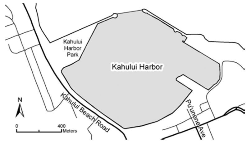
Kahului Harbor
Location: Kahului Harbor is the primary port on the northern coast of Maui. The Fisheries Management Area is bounded seaward by a line between the seaward edges of the breakwaters, as shown. Permitted activities shall not be construed as allowing activities within any portion of the harbor which may otherwise be prohibited by laws or rules of the Department of Transportation.
Permitted
To use a landing net with stretched mesh of 2 inches or greater to secure hooked or otherwise detained marine life.
To use a hand net while on shore to take shrimp or other marine life, provided the diameter of the net is not more than 8 inches and the handle is not more than14 inches long.
Prohibited
To use any net, except as indicated in permitted activities above.
To take or possess a total of more than 50 marine life per person per day.
To snag any marine life.
To use more than two poles with one line and up to two hooks per pole, each hook having only one point, except that double or treble hooks are allowed with lures.
To take, attempt to take, or possess any marine life from the area or use any fishing gear in the area that may otherwise be prohibited.
Kahekili
Location: Kahekili Herbivore Fisheries Management Area is located off north Kā'anapali. The northern boundary is a straight line extending 1292 yards west from Honokōwai Beach Park, the southern boundary is a straight line extending 335 yards west from Hanaka'ō'ō Beach, and the seaward boundary is a straight line connecting the seaward endpoints of the northern and southern boundaries, as shown.
Permitted
To fish for, injure, kill, possess, or remove any finfish or invertebrate, except prohibited species indicated below.
To use bait or other attractants while fishing for permitted marine life.
Prohibited
To injure, kill, possess, or remove any rudderfish (nenue), parrotfish (uhu), or surgeonfish.
To injure, kill, possess, or remove any sea urchin.
To feed or deliberately introduce any attractant, directly to or in the vicinity of any marine life, except while fishing for permitted marine life.
LĀNA‘I
Mānele-Hulopo‘e Marine Life Conservation District
Location: The Mānele-Hulopo‘e Marine Life Conservation District is located in the waters offshore of Palawai and Kamao on the southwestern coast of Lāna‘i. Subzone A refers to the area bounded seaward by a line from Kaluako‘i Point to Flat Rock, then to Pu‘u Pehe Rock. Subzone B refers to the area bounded seaward by a line from Pu‘u Pehe Rock to Kalaeokahano Point. The Division of Boating and Ocean Recreation has established rules relating to boating, anchoring and mooring within the Mānele-Hulopo‘e Marine Life Conservation District, as indicated.
Permitted
To fish for, take or possess any finfish or ‘a‘ama crab by pole-and-line from the shoreline only.
To possess the following gear: pole and line, one knife, one hand net with frame no more than 3 feet in diameter (excluding handle), any legal fishing gear while on a vessel transiting to or from Mānele Boat Harbor within the harbor channel or the Harbor, but that fishing gear may not be in the water.
With a permit to engage in activities otherwise prohibited by law for scientific, propagation or other purposes.
Prohibited
To fish for, take or injure any marine life (including eggs), or possess any fishing gear, except as indicated in permitted activities above.
To take or alter any sand, coral or other geological feature or specimen.
To operate, anchor or moor any vessel within Subzone A. (Manually-propelled Hawaiian outrigger canoes may be operated, but not anchored or moored, in theSubzone.)
To operate, anchor or moor a vessel in such a way as to damage marine life or geological features anywhere in the MLCD.
Mānele Harbor
Location: Mānele Harbor is a small boat harbor on the southern coast of Lāna‘i. Area 1 refers to the shoreline portion of the entrance channel and basin, bounded seaward by a line connecting the seaward tip of the three groins along the shoreline. Area 2 refers to the breakwater portion of the entrance channel. Permitted activities should not be construed as allowing activities within any portion of the harbor which may otherwise be prohibited by laws or rules of the Division of Boating and Ocean Recreation.
Permitted
To use and possess crab nets, hand nets for shrimp, and landing nets within Areas 1 and 2, provided the net’s frame is no more than 3 feet in diameter (excluding handle).
To possess but not use nets on board vessels within Area 2.
Commercial fishers with a Bait License may use and possess nets within Areas 1 and 2 to take baitfishes.
Prohibited
To use or possess any type of net within Areas 1 and 2 except as indicated in permitted activities above.
CATCH AND RELEASE
To help improve the quality of fishing in Hawai‘i, fishers are encouraged to take only what you need from the sea, and release fish safely whenever possible. To enhance survival of released fish, please follow these guidelines.
Quickly play and release fish.
Keep fish in water as much as possible.
Gentle handling is essential.
Remove hook quickly with pliers, or cut line. Barbless hooks are preferred.
Revive unconscious fish by holding upright in water and moving back and forth, forcing water over gills.
Don't hold by eye sockets. Blindness or death may result.
Be selective about the fish your take. If you catch an undesirable fish, let it go carefully so it can remain part of the food chain. By fishing wisely, we can maintain an important renewable resource.
MOLOKA‘I
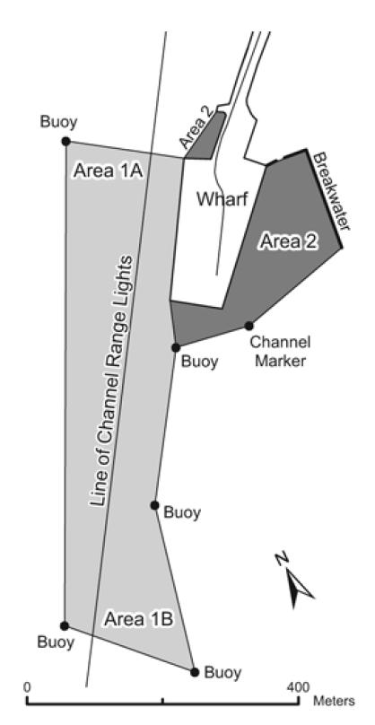
Kaunakakai Harbor
Location: Kaunakakai Harbor is located on the southern coast of the island of Moloka‘i. As shown in the map at right, portions of the commercial harbor designated “Area 1A” and “Area 1B” are separated by a line extending from the Channel Range Lights, and portions of the small craft harbor are designated “Area 2”.
Permitted
Within Area 1A, fishing with thrownet or pole and line; taking baitfish in season, with a bait license; and fishing with nets a) with a permit from the Board of Land and Natural Resources, b) with clearance from the Department of Transportation, and c) except at night when nets may not be set, nor remain in the water unless to complete unloading fish.
Within Area 1B, fishing with thrownet or pole and line.
Within Area 2, fishing with pole and line; using hand nets no longer than 3 feet in any dimension to take shrimp or land fish already hooked.
Prohibited
Within Area 1A, using nets except as described above; obstructing passage of vessels.
Within Area 1B, using any type of net except thrownet.
Within Area 2, using any type of net, except hand nets as described above.
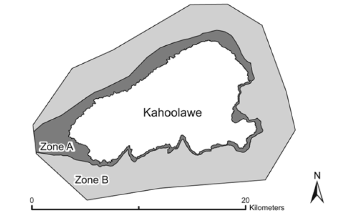
Kaho‘olawe Island Reserve
Location: Kaho‘olawe Island Reserve includes the island of Kaho‘olawe and surrounding waters seaward to a distance of two nautical miles.
DANGER: The Reserve is a former military range, and unexploded ordnance is present on the island and in surrounding waters.
Permitted:
Cultural, spiritual, subsistence, preservation, restoration, educational, and fishing activities specifically authorized by the Kaho‘olawe Island ReserveCommission.
Prohibited:
All entrance into and activities within the Kaho‘olawe Island Reserve, including all manner of boating, fishing, and diving, unless specifically authorized by theCommission.
Contact the Kaho‘olawe Island Reserve Commission at 586-0761 (Oahu) or 243-5889 (Maui) for further information.
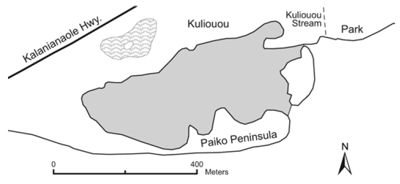
Paikō Lagoon Wildlife Sanctuary — O‘ahu
Location: The Paikō Lagoon Wildlife Sanctuary includes all of the State owned land areas adjacent to Paikō Lagoon, and water areas within Paikō Lagoon.
Prohibited:
To remove, disturb, injure, kill or possess any form of plant or wildlife (no fishing).
To introduce any form of plant or wildlife.
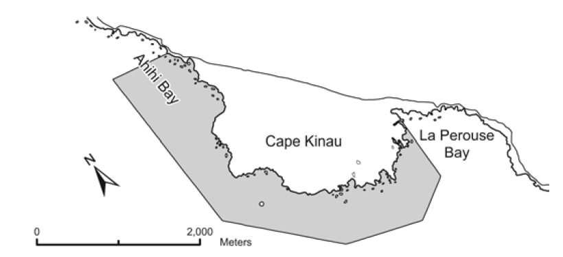
‘Āhihi-Kīna‘u Natural Area Reserve — Maui
Location: ‘Āhihi-Kīnau shore waters include the waters seaward of Cape Kīnau a distance of 2000 to 3000 feet as shown above.
Prohibited
To remove, injure or kill any form of plant or animal (no fishing).
To introduce any form of plant or animal life.
To operate, anchor or moor any motorized vessel.
Fishing and other activities may be restricted in other areas of the State under the jurisdiction of other divisions of the Department of Land and Natural Resources and other governmental agencies. Some of these areas include:
Department of Land and Natural Resources — Alaka‘i Wilderness Preserve, Kaua‘i; Waikīkī restricted areas, O‘ahu; Kanahā Pond Wildlife Sanctuary, Maui; Waimanu Estuarine Sanctuary, Hawai‘i; Hawai‘i State Seabird Sanctuary (various statewide islands and islets); small boat harbor facilities.
Department of Transportation — Commercial harbor facilities.
U.S. Fish and Wildlife Service — National Wildlife Refuge areas.
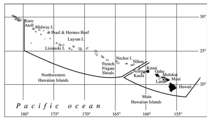
NORTHWESTERN HAWAIIAN ISLANDS
Location: The Northwestern Hawaiian Islands Marine Refuge includes the waters extending three miles seaward of any coastline from Nihoa Island to Kure Atoll, excluding Midway Atoll.
Entry into the refuge is prohibited without a permit.
Fishing or taking of marine life within the refuge is prohibited.
Native Hawaiian traditional and customary practices are allowed with a permit.
GEAR RESTRICTIONS
Thrownets
Minimum size 2 inch stretched mesh.
Possession of thrownets with mesh size less than 2 inches in or near the water where fish may be taken is unlawful.Unlawful to sell thrownets with mesh size less than 2 inches.
Gill, draw, drag or seine, or other nets
Minimum size for nets generally 2 inch stretched mesh.
Unlawful to leave any gill net unattended without visually inspecting the net every two hours and releasing or removing any undersized, illegal or unwanted catch.
Unlawful to leave any gill net in the water for a period of more than four hours in any twenty-four hour period.
Exceptions
All persons may use hand nets or scoop nets of smaller mesh to take fish and other marine life for noncommercial purposes only, provided the net, including handle and other attachments, does not exceed three feet in any dimension.
Licensed pond owners or operators may use nets of smaller mesh to take young mullet (pua) to stock their ponds.
Commercial Marine licensees with a Bait License may use nets of smaller mesh to take ‘iao, Marquesan sardine, gold-spot herring, or any other species for which the Department declares an open season for use as bait.
All persons may use nets of smaller mesh to take shrimp (‘ōpae), ‘ōpelu, and makiawa.
All persons using surround nets with SCUBA may use nets of not less than one and one-half inches to bag and transport fish captured with legal gear to the shore or boat.
See provisions relating to the taking of akule (halalū) and nehu, and provisions affecting particular areas.
Akule nets
Unlawful for any person without a valid commercial marine license to take akule with any net that has less than 2¾" stretched mesh, except landing nets as indicated below.
Unlawful for any person without a valid commercial marine license to take akule using the bag net fishing method.
Unlawful for any commercial marine licensee to take akule while using:
lay net fishing method with net that has less than 2¾" stretched mesh;
surround net fishing method with net that has less than 2½" stretched mesh;
bag net fishing method with net that has less than 1½" stretched mesh;
Unlawful for any commercial marine licensee to keep akule in a bag net in the ocean for more than 3 days without notifying the department, explaining the reasons, and when the bag net will be removed. Immediate removal may be required if necessary to prevent waste of akule or alleviate public safety risk.
Use of landing nets of any mesh size is permitted, provided the opening of the landing net is less than 4 feet in any dimension, excluding handle.
Drift nets
Possession or use of drift gill nets prohibited in State waters.
Lay nets Dimensions
Minimum size 2¾ inch stretched mesh; maximum net size 125
Registration and identification
Nets must be registered with the Department, and tagged as specified, attached at each end of the float line and the lead line (four attachment points per net).
Unlawful to falsely tag any lay net not registered with the Department.
Nets must be marked by surface buoys as specified; buoys shall display the registration number, be marked with reflective tape, and be visible above the surface of the water. Buoys must be attached to each end of the float line (two buoys per net).
Any lay net in, on, or about the water that is not registered or does not have proper identification tags or surface buoys will be considered contraband and subject to immediate seizure by the Department.
Registered owners are responsible for any lay net that is lost, destroyed, sold, traded, stolen, given away, or otherwise no longer their property or in their possession until a report is filed with and confirmed by the Department.
Fishing
Lay nets may not be used during the period from ½ hour after sunset to ½ hour before sunrise.
Unlawful to fish with more than one lay net at a time.
Unlawful to leave a lay net unattended for more than ½ hour.
Lay nets must be inspected completely within 2 hours after the beginning of the set. All threatened, endangered, prohibited, or unwanted species must be released.
Lay nets may not be used for more than 4 hours during any set. After the end of one set, the same lay net may not be used again within 24 hours. The same person may not set another lay net within 24 hours after the end of a set.
Lay nets may not be used in water more than 25 feet deep, except that commercial marine licensees may use lay nets in water up to 80 feet deep.
Unlawful to use a lay net within 250 feet of another lay net.
Multi-panel lay nets are prohibited.
Unlawful to retrieve a lay net in a manner that causes any stony coral to break from its attachment to the bottom, or into smaller pieces. No stony coral may be brought to the surface in the net.
Unlawful to discard, abandon, or leave any lay net, or portion thereof, in the water for longer than 4 hours.
Lay nets may not be used in freshwater streams or stream mouths.
Prohibited areas
Unlawful to use lay nets within 3 miles of the shoreline around the entire island of Maui, and in the following waters off O‘ahu: south shore from Kawaihoa Pt. to Keahi Pt.; Kailua Bay from Mōkapu Pt. to Wailea Pt.; Kāne‘ohe Bay between the sampan and ship channels. Detailed maps available at DAR offices.
Moloka‘i special rules for lay nets
Maximum net size 750 feet long and 7 feet high; minimum size 2-3/4 inches stretched mesh.
Nets must be registered with the department, and tagged as specified.
Nets must be marked with at least 2 surface buoys at each end; buoys must display the registration number, be marked with reflective tape, and be large enough to be visible to the naked eye from a distance of 1,320 feet.
Lay nets may not be set for more than 12 hours, and once finished, cannot be used again for at least 24 hours.
Lay nets may not be set within 1,320 feet of another lay net already set.
Lay nets must be inspected at least twice along the entire length during the set. All unwanted, prohibited, threatened or endangered species must be released.
Traps
Minimum mesh size: Netting – stretched mesh 2 inches; Rigid material – 2 inches by 1 inch. Entrance cones for traps have no minimum mesh size.
Traps for shrimp and ‘opae have no minimum mesh size.
Traps must be portable and not exceed 10 feet in length or 6 feet in height or width.
Aquarium purposes
Any person with facilities for keeping live fish in reasonably good health may apply for an Aquarium Fish Permit to legally use fine mesh traps or nets (other than thrownets) for taking certain aquatic life.
Noncommercial aquarium fish collectors are limited to a combined total of 5 fish or aquatic life specimens per person per day.
Bullpen traps
Total length of a “bullpen” trap may not exceed 2,000 feet (including the length of the guide(s) and pen), and total soak time may not exceed 16 hours. Bullpen traps must be set more than 1,000 yards from shore, except on Moloka‘i where they may be set beyond 500 yards from shore west of KaunakakaiWharf, and beyond 200 yards from shore east of Kaunakakai Wharf.
Unlawful to discard or otherwise dispose of any fishing net, trap, or gear, or parts thereof, in the waters of the State.
Firearms and spears
Fishing with spears allowed for all fishes, but must follow minimum size for spearing of certain species, closed seasons and other restrictions. Unlawful to spear any crustacean (except introduced freshwater prawn), turtle or aquatic mammal at any time.
Unlawful to pursue, take or kill any fish, crustacean, mollusk, turtle, or marine mammal with firearms, except tuna and billfish that have been gaffed, and sharks.
Drones (unmanned aerial vehicles)
Unlawful to possess or use any drone for the purpose of taking aquatic life except with a permit.
Drones may be used for simple reconnaissance.
Explosives, electro-fishing devices, chemicals, poisons and intoxicants
Unlawful to fish with, attempt with, or to have in possession on or near the shore where fish can be taken.
Permits may be issued for certain legitimate purposes.
O‘AHU AQUARIUM FISHING
Unlawful, within three nautical miles of the O‘ahu shoreline, while possessing a small mesh net authorized under a commercial or recreational aquarium fish permit:
to possess a small mesh net more than 30 feet long or six feet high, or to join more than two such nets together for a combined length of more than 60 feet;
to take or possess any ornate butterflyfish, oval butterflyfish, or reticulated butterflyfish.
Unlawful, within three nautical miles of the O‘ahu shoreline, while possessing a small mesh net authorized under a commercial aquarium fish permit:
to possess a small mesh net and take or possess a daily bag limit of more than:
six of any of the following: yellow tang less than 1½ inches in length, yellow tang more than 5 inches in length, kole more than 5 inches in length, cleaner wrasse of any size;
two bandit (banded) angelfish more than 5½ inches in length. l to operate a vessel with more than the above daily bag limits for the number of permittees on board, or more than three times the number of any bag limit, regardless of the number of permittees on board.
Note: Commercial aquarium collection is prohibited pending compliance with HRS Chapter 343 environmental review.
SPECIAL PROVISIONS, LICENSES, PERMITS
Closed Season License (lobster and Kona crab)
During the closed season, a dealer may sell, or a hotel or other public eating establishment may serve spiny lobster, slipper lobster, or Kona crab lawfully caught in the waters of the State during the open season by first obtaining an appropriate Special Marine Animal or Product Possession and Sale License.Also, see special provisions applicable to commercial fishing in the Northwestern Hawaiian Islands, and to imported marine life. License fee $50. Duplicate $10.
Baitfish License
Commercial fishermen may apply for a license to take baitfish other than nehu for use in fishing operations where fish are caught and landed in the State. No baitfish caught may be sold or transferred except for bait purposes. License fee $50. Duplicate $10.
A license for taking nehu may be issued to persons employed on live-bait tuna boats, only if the person’s principal means of livelihood is derived from tuna fishing and the sale of tuna, and the fish are caught and landed in the State; such nehu may not be sold to others.
Each license shall cover the operation of one fishing vessel, and must be carried aboard the boat at all times. Each licensee must furnish monthly baitfish catch reports to the Department of Land and Natural Resources.
Imported marine life
Unlawful to possess, sell or offer for sale any aquatic life or product thereof of any size taken outside the waters of the State, when the taking, possession or sale of the same species is restricted if taken within the waters of the State, without first obtaining an appropriate Special Marine Animal or Product Possession and Sale License. License fee $50. Duplicate $10.
Scientific, educational or propagation purposes
Any person with a bona fide scientific, educational or propagation purpose may apply in writing to obtain a Special Activity Permit to legally take certain aquatic life, use certain gear, and gain entrance into certain areas otherwise prohibited.
Freshwater game fishing
Unlawful to fish for, catch or take any freshwater game fish without first obtaining a Freshwater Game Fishing License. License fee $5 (residents over 15 years of age, military personnel on active duty in the State and their spouse and dependents over 15 years of age); $3 (all minors between nine and 15 years of age); no charge (all senior citizens 65 years of age or over); $25 (non-resident); $10 (7-day tourist), and $20 (30-day tourist). Minors below nine years of age may fish without a license when accompanied by a licensee. Duplicate $1.
Where bag limits are specified, each licensee may take only one bag per day. The catch of a child below nine years of age will be considered part of the catch of the licensed supervising adult accompanying the child. A child below nine years of age who wishes to take a bag limit on his/her own must purchase a valid freshwater fishing license.
Unlawful to sell introduced freshwater game fish.
FISHER HARASSMENT
Unlawful to prevent or attempt to prevent the lawful taking of fish by licensed freshwater anglers, including by means of affecting behavior of fish, affecting personal property for fishing, or obstructing access to fishing areas.
Unlawful to enter or remain on public lands or waters, or private lands or waters without landowner’s permission, for this purpose.
LONGLINE FISHING
Defined: Longline fishing is conducted with gear consisting of at least one mainline over one nautical mile in length, to which is attached a number of branchlines with baited hooks. The mainline is suspended below the surface by floatlines attached to surface floats.
Unlawful to engage in longline fishing within state waters, or sell or offer for sale any marine life taken with longline fishing gear within state waters.
Unlawful to possess, sell or offer for sale any marine life taken by longline fishing gear which is prohibited by or in violation of rules adopted by the Western Pacific Fishery Management Council through the National Oceanic and Atmospheric Administration.
COMMERCIAL FISHING
Individuals or vessels engaged in taking, selling or offering for sale any marine life for commercial purposes (including charter fishing services) must obtain aCommercial Marine License. License fee resident $100, non-resident $250. Dup. $10.
“Commercial purpose” means the taking of marine life for profit or gain, or as a means of livelihood, when the marine life is taken in or outside of the State, and when the marine life is sold, offered for sale, landed, or transported for sale anywhere in the State.
Every commercial marine licensee shall furnish to the Department of Land and Natural Resources a monthly report with respect to marine life taken and any bait used. The report shall be submitted not later than the tenth day of the month following the month in which the marine life was taken. Failure or refusal to submit a monthly catch report shall be cause for revocation of the commercial marine license.
RELEASE of NON-NATIVE AQUATIC LIFE
No person shall release any live non-native fish or other live non-native aquatic life into any waters of the State.
DIVE FLAGS
Spearfishers and other divers must mark their position with a dive flag, and may not surface more than 100 feet from the dive flag while diving in ocean waters(50 feet in navigable streams) except in an emergency.
Dive flags shall be displayed only when diving is in progress, and must be removed from the water when no diving is in progress.
Dive flags displayed on the surface of the water must be a minimum of 12”x12”. If mounted on a vessel greater than 16 feet in length, dive flags must be a minimum of 20”x24” and displayed with a blue and white alpha flag.
Between sunset and sunrise dive flags must be illuminated so as to be identifiable from 100 feet away.
BOTTOM FISHING
"Deep 7" bottomfish species covered by these rules include: ‘ula‘ula koa‘e or onaga, ‘ula‘ula or ehu, kalekale, ‘ōpakapaka, ‘ūkīkiki or gindai, hāpu‘u, and lehi. (For species names see p. 16.)
Closed season
Unlawful to fish for, possess, or sell bottomfish species listed above during the announced closed season, except by permit.
Gear restrictions
Unlawful to take bottomfish with any trap, trawl, bottomfish longline or net. Unlawful to possess, while on board a vessel, both bottomfish and any trap, trawl, bottomfish longline, or net other than scoop net or Kona crab net. Scoop nets may be used to bring on board a vessel any bottomfish that has already been caught. Kona crab nets may be used to take Kona crabs.
Trip reporting
Commercial fishers must report all “Deep 7” bottomfish catches within five days after the end of a trip.
Minimum size
Onaga and ‘ōpakapaka minimum size for sale is one pound.
Non-commercial bag limits
Unlawful for any person without a current commercial marine license to take or possess more than a combined total of five bottomfish per day.
Bottomfish restricted fishing areas (BRFAs)
All BRFAs are now open to bottom fishing.
Bottomfish fishing vessel identification number
All vessels fishing for or possessing bottomfish must first be registered with the department and must display the bottomfish fishing vessel identification number. This number consists of the HA number, NMFS federal fishing number, Coast Guard documentation number, or DAR-issued number, followed by the letters “BF” as a suffix. Letters must be no less than six inches high and three inches wide in black or contrasting solid color to the background and placed on both sides of either the hull or the superstructure. The bottomfish fishing vessel identification number shall be valid from Sep 1 to Aug 31, and must be renewed annually.
SHARK FINS
Unlawful to possess, sell, offer for sale, trade, or distribute shark fins. Shark fin is defined as the raw or dried fin or tail of a shark.
SHARK FEEDING
Unlawful to conduct any activity related to the feeding of sharks in state waters.
Persons engaged in taking marine life that results in captured, injured or dead fish being incidentally eaten by sharks are not in violation, provided the purpose of taking marine life is not the feeding of sharks.
Persons may feed sharks for traditional Hawaiian cultural or religious practices, provided the feeding is not part of a commercial activity.
SHARKS and RAYS
Unlawful to knowingly capture, take, possess, abuse, or entangle a shark or ray, whether alive or dead, or kill any shark or ray within state waters.
CLEANING and DISCARDING CATCH
In the interest of safety, fishers are strongly encouraged to avoid cleaning their catch and discarding fish parts in areas frequented by swimmers and other water users.
FISH AGGREGATING DEVICES (FADS)
Prohibited
Unlawful to attach, moor or tie any boat or watercraft, or any rigging or structure to, or to board, deface, damage, remove or destroy any fish aggregating device.
Exceptions
Permits may be issued for certain activities.
Catch Reporting
Commercial fishermen must report FAD catches on their monthly catch reports.
Current Fish Aggregating Device locations and status can be found on the DAR website at http://dlnr.hawaii.gov/dar/fis... Links to downloadable maps (locations) and the UH FAD site (status) are at the bottom of the page.
SAFE FISHING PRACTICES FOR SEA TURTLES
Prevention
Do not cast your line where turtles are seen surfacing to breathe.
If you hook or entangle a turtle
Gently bring turtle close to you. Use dip net or firmly hold front flippers and shell to safely lift out of water.
Cut line close to hook and remove line that has become entangled around turtle. AVOID turtle’s mouth and flipper claws; use blunt scissors/knife to cut line.
Do not lift turtle above water by pulling line - this will result in further injury. If distance to you from boat/pier/cliff is too great or turtle is too large, cut line as short as possible to release turtle.
Do not remove hook unless turtle is lightly hooked and it can be taken out without further injury. If uncertain, DO NOT remove hook.
Turtles with serious cuts, ingested or deeply embedded hooks need veterinary care. Keep turtle in shade. Immediately call the NOAA Turtle Research Program hotline at 725-5730. Weekends and holi-days call the DOCARE hotline at 643-DLNR (3567).