Marine Area 7
(All marine waters north of the Trial Island line described under Area 6 to the United States-Canada boundary)
Species |
Season |
Additional Rules |
Trout |
Year-round |
Catch-and-release. |
Steelhead |
Year-round |
Daily limit 2 hatchery steelhead. |
Sturgeon |
Year-round |
Catch-and-release. |
Mackerel |
Year-round |
No min. size. No daily limit. |
Herring, Anchovy, Sardine, Sand Lance, and Smelt |
Year-round |
No min. size. Daily limit 10 lbs., all species combined. All smelt caught must be kept and count toward the daily limit except Closed to eulachon (Columbia River smelt). Herring - Closed year-round north of a line from Sandy Point to Patos Island to the Canadian boundary. For smelt: Jig gear may be used 7 days a week. Dipnets may be used from 6:00 a.m. until 10:00 p.m. Fridays through Tuesdays. |
Pacific Halibut |
Check the WDFW website at https://wdfw.wa.gov/fishing/regulations/halibut or call (360) 902-2700 in April for information on Pacific halibut seasons and regulations. No min. size. Daily limit 1. Annual limit 4. Descending device required onboard vessels. |
|
Other Food Fish |
Year-round |
No min. size. Daily limit 2 of each species. See Definitions. |
All Other Fish |
CLOSED |
CLOSED to fishing for, retaining, or possessing. |
Salmon |
||
Entire Area |
July 13-July 15 |
Chinook - min. size 22”. Other salmon species - no min. size. Daily limit 2 including no more than 1 Chinook. Release chum, wild coho, and wild Chinook. Additional openings may occur based on available quota. Check the WDFW website at |
Aug. 1-Aug. 31 |
No min. size. Daily limit 2. Release Chinook, chum, and wild coho. |
|
Sept. 1-Sept. 30 |
No min. size. Daily limit 2. Up to 1 coho may be retained. Release Chinook and chum. |
|
Lummi Bay |
July 13-July 15 |
Chinook - min. size 22”. Other salmon species - no min. size. Daily limit 2 including no more than 1 Chinook. Release chum, wild coho, and wild Chinook. Additional openings may occur based on available quota. Check the WDFW website at |
Aug. 1-Aug. 31 |
No min. size. Daily limit 2. Release Chinook, chum, and wild coho. |
|
Sept. 1-Sept. 4 |
No min. size. Daily limit 2 including no more than 1 coho. Release Chinook and chum. |
|
Sept. 5-Sept. 30 |
CLOSED. |
|
Samish Bay |
Year-round |
CLOSED. |
Yellow and Low Islands Preserve |
Year-round |
CLOSED. |
Southern Rosario Strait/Eastern Strait of Juan de Fuca |
Year-round |
CLOSED. |
Bellingham Bay |
July 1-Aug. 15 |
CLOSED. |
Aug. 16-Sept. 30 |
Chinook - min. size 22”. Other salmon species - no min. size. Daily limit 4. |
|
Oct. 1-June 30 |
CLOSED. |
|
Bottomfish |
||
Year-round season. Daily limit is a total of 15 bottomfish (see Definitions) subject to individual limits and seasons shown below. See closures . Fishing for bottomfish prohibited in waters deeper than 120’. Descending device required onboard vessels. |
||
Lingcod |
May 1-June 15 |
Hook and line season. Min. size 26”. Max. size 36”. Daily limit 1. |
May 21-June 15 |
Spearfishing season. Max. size 36”. Daily limit 1. |
|
Surfperch |
Year-round |
No min. size. Daily limit 10. Except shiner perch daily limit 15: not included in bottomfish limit. |
Rockfish |
CLOSED |
CLOSED to fishing for, retaining, or possessing. |
Pacific Cod, Pollock, Hake |
Year-round |
No min. size. Daily limit 2 of each species. |
Cabezon |
May 1-Nov. 30 |
Min. size 18”. Daily limit 1. |
Wolf-Eel |
Year-round |
CLOSED to retention. |
Sixgill, Sevengill, and Thresher Sharks |
CLOSED |
CLOSED to fishing for, retaining, or possessing. Sixgill shark may not be removed from the water. |
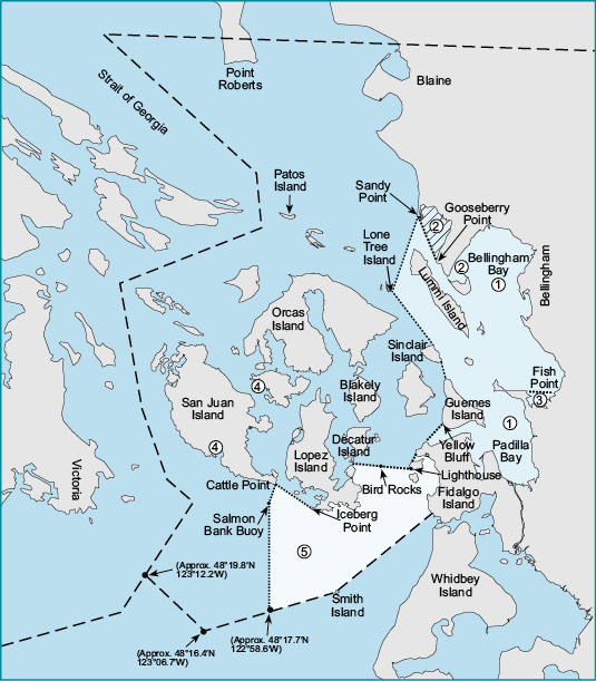
1Bellingham Bay: Waters of Bellingham and Padilla bays south and east of a line from Sandy Pt. to the northern most point of Lone Tree Island, easterly to the northeast point of Sinclair Island, then from the southeastern most point on Sinclair Island to Clark Pt. and true west from Yellow Bluff (southwest corner of Guemes Island) to Yellow Bluff Reef Range Marker to Washington State Dept. of Transportation ferry terminal dock east of Shannon Pt. and north of the railroad bridges at Swinomish Slough.
2Lummi Bay: Waters east of a line from Gooseberry Point to Sandy Point. Reservation Closed to non-Indian fishing and/or access.
3Samish Bay Closure: Waters of Samish Bay lying south of a line running true east from Fish Point.
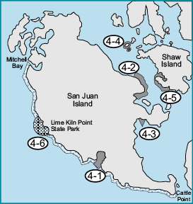
4San Juan Islands Marine Preserve (False Bay, Friday Harbor, Argyle Lagoon, Yellow and Low Islands, and Shaw Island): Closed to all shellfish and bottomfish activity (except crabbing in Parks Bay on Shaw Island).
4-1False Bay: The tidelands and bedlands of False Bay on San Juan Island, including all University of Washington (UW)-owned tidelands beginning at a marker 400’ east of the east entrance of False Bay and extending to the entrance of False Bay, all UW-owned tidelands and bedlands within a line beginning at the UW marker on the shore at the east entrance of False Bay, projected 500 yards offshore, then northwest to a point 500 yards offshore along a line projected from a UW marker on the shore at the west side of a small peninsula at the west entrance of False Bay, then to shore along the line to the marker, and all UW-owned tidelands west of the marker to a UW marker 600’ west of the small peninsula.
4-2Friday Harbor: Those tidelands and bedlands adjacent to San Juan Island within a line beginning on the shore 500 yards west of Point Caution, then 500 yards offshore, then south and east following the shoreline to the intersection with a line projected from a UW marker located 100’ north of the north entrance of the floating breakwater of the Port of Friday Harbor and projected toward Reid Rock Buoy, then along the line to shore on San Juan Island.
4-3Argyle Lagoon: Those UW-owned tidelands and all bedlands enclosed by the inner spit of Argyle Lagoon on San Juan Island.
4-4Yellow and Low Islands Preserve: All tidelands and bedlands within 300 yards of Yellow Island and 300 yards of Low Island.
4-5Shaw Island: Those tidelands and bedlands within a line beginning at a UW marker on the shore at Hicks Bay 122°58.25’W longitude, then due south 500 yards, then north and west at a distance of 500 yards from shore to the intersection with a line projected 261° true from a UW marker on the shore of Parks Bay, which passes just south of the unnamed island at the north end of Parks Bay, then along the line to the shore of Shaw Island, including all tidelands and bedlands of Parks Bay south of the line.
4-6Voluntary Whale Protection Zone: WDFW encourages anglers to avoid waters extending a quarter-mile from shore from Mitchell Bay to Cattle Point except around Lime Kiln Point where the zone extends a half mile from shore.
5Southern Rosario Strait/Eastern Strait of Juan de Fuca: Waters of Area 7 in Rosario Strait and the eastern portion of the Strait of Juan de Fuca southerly of a line running true south from the westernmost point on Fidalgo Head to Burrows Island, then westerly and southerly along the shore of Burrows Island to the Burrows Island Lighthouse, then westerly to Bird Rocks, then westerly from Bird Rocks to the southernmost point on Decatur Island, then southerly across Lopez Pass to Lopez Island and following the shore of Lopez Island southerly and westerly to Iceberg Point, then from Iceberg Point to Cattle Point, then south southwest to the Salmon Bank Buoy and then true south from the Salmon Bank Buoy to the Area 7 boundary.