Access Sites
Please see below for a map of saltwater boating access sites throughout Rhode Island. The sites are State-owned and currently in usable condition. A list of these locations with brief descriptions is found below. More boating access sites, such as town-owned ramps, and additional information can be found on the Marine Fisheries website at http://www.dem.ri.gov/programs/bnatres/fishwild/boatlnch.htm#salt.
When utilizing these boating access sites, please be respectful of other users and properly dispose of all trash and waste.
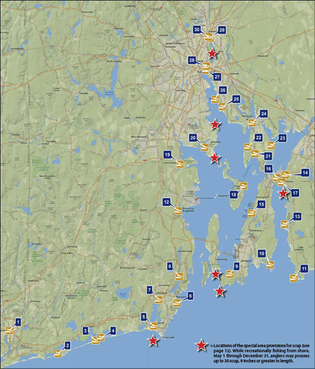
Town |
Site # |
Name |
Description |
Depth |
Westerly |
1 |
Main Street |
Main St., concrete slab ramp |
4 ft. |
Charlestown |
2 |
Quonochontaug Breachway |
Off West Beach Rd., concrete plank ramp |
3 ft. |
3 |
Charlestown Breachway |
West end of Charlestown Beach Rd., linked concrete slabs |
3 ft. |
|
4 |
Charlestown |
Off of Charlestown Beach Rd. Natural Shoreline, gravel base |
N/A |
|
Narragansett |
5 |
Galilee |
Corner of Galilee Rd., and Great Island Rd., southeast side of Great Island Bridge. Linked concrete planks - double ramp |
4 ft. |
6 |
Monahan's Dock |
East Side of Ocean Rd., at South Pier Rd., concrete - steep drop |
3 - 4 ft. |
|
South Kingstown |
7 |
Narrow River |
Off Middlebridge Rd. on Pollock Ave., concrete planks |
3 ft. |
8 |
Marina Park |
Route 1., concrete slabs |
N/A |
|
Newport |
9 |
Fort Adams |
Off Harrison Ave. |
3 ft. |
Middletown |
10 |
Third Beach |
Concrete ramp. Parking fee when beach is open |
N/A |
Little Compton |
11 |
Sakonnet Point |
Sakonnet Point Rd. (Rt. 77). North side of Town Landing Rd., linked concrete planks |
2 ft. |
North Kingstown |
12 |
Wilson Park |
East end of Intrepid Dr., off Post Rd., Rt. 1, near fire station. Linked concrete plank - moderately steep |
3 ft. |
Tiverton |
13 |
Fogland |
End of Fogland Rd., at High Hill Rd. Linked concrete planks |
N/A |
14 |
Sakonnet River Bridge |
Underneath new Sakonnet bridge., off Riverside Dr. concrete planks, strong currents |
N/A |
|
Portsmouth |
15 |
Weaver Cove |
On Burma Rd. South of Melville complex. Concrete slabs |
4 ft. |
16 |
Gull Cove |
Accessed via turnoff from RI 138 E/24 E. Linked concrete planks |
2 ft. |
|
17 |
Stone Bridge |
Off Rte. 138 at junction of Park Ave and Point Rd., at Teddy's Beach |
3 ft. |
|
Prudence Island |
18 |
Homestead |
On Prudence Island, off Narragansett Ave., north of Prudence Variety |
N/A |
East Greenwich |
19 |
Greenwich Cove |
Pole #6, Crompton Ave. Concrete slab |
N/A |
Warwick |
19 |
Goddard |
Goddard State Park |
N/A |
20 |
Oakland Beach |
Warwick Cove. Oakland Beach Ave. Take last left. East side of Oakland Beach. Concrete ramp |
<4 ft. |
|
Bristol |
21 |
Independence Park |
At the foot of Church St., off of Rt. 114. Linked concrete slab |
N/A |
22 |
Colt State Park |
Off of Hope St. (Rt. 114), concrete ramp |
4 ft. |
|
23 |
Annawanscutt |
Annawanscutt Dr., off Metacom Ave. (Rt. 136), past Veteran's Home. Linked concrete planks |
>2 ft. |
|
Warren |
24 |
Warren |
West side of Water St., at Wheaton St., cement slab |
N/A |
Barrington |
25 |
Haines Park |
On Bullock's Cove, off Metropolitan Park Dr. concrete slab |
4 ft. |
East Providence |
26 |
Sabin Point |
Off Bulluck's Point Ave. Hard packed Sand |
N/A |
27 |
Bold Point |
Off Veteran's Memorial Pkwy., via Mauran Ave. at the end of Pier Rd. Concrete slab |
4 ft. |
|
Providence |
28 |
Gano Park |
End of of East Transit St. Concrete slab |
N/A |
Pawtucket |
29 |
Festival Pier |
End of Tim Healey Way, off of School St. (Rt. 114). Concrete slab |
N/A |
30 |
Pawtucket |
East side of Taft St., just south of Rt. 95 bridge. Linked concrete planks |
N/A |
|
* Please note that some boating access sites may require a permit or fee for parking and/or use. N/A= Information not available |
||||