Western Oregon Unit Map
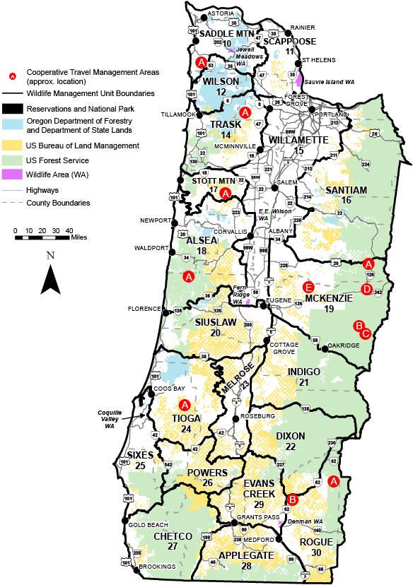
Wildlife Management Units
For the purpose of managing Oregon’s wildlife, the state has been divided into separate wildlife management units. Unit numbers are identifiable in smaller subunits by the last 2 digits of the number assigned to the rule description.
Maps are available from the Bureau of Land Management (BLM), National Forest (NF), or Oregon Department of Forestry (ODF), as indicated following each description.
Alsea #18
42% public lands. Beginning at Corvallis; southwest on State Hwy 34 to Decker Rd; southeast on Decker Rd to Bellfountain Rd; south on Bellfountain Rd to Bellfountain; east on Dawson Rd (Co Rd 45200) to State Hwy 99W; south on State Hwy 99W to Monroe; south on Territorial Rd to State Hwy 36; southwest on State Hwy 36 to north shoreline of Triangle Lk; southwest on Triangle Lk shoreline, Lk Cr, Siuslaw Rvr and north shoreline of Siuslaw Bay to Pacific Ocean; north on Pacific Ocean coastline to north shoreline of Siletz Bay; east on north shoreline of Siletz Bay, Siletz Rvr and S Fork of Siletz Rvr to Valsetz; east on Valsetz-Falls City main Co Rd to Falls City; southeast on Bridgeport Rd (No. 864), Gardner Rd (No. 865) and Airlie Rd (No. 7) to State Hwy 99W; south on Hwy 99W to Corvallis, point of beginning. (Maps: Siuslaw NF, Eugene/Salem BLM)
Applegate #28
57% public lands. Beginning at Grants Pass; east and southeast on I-5 to Oregon-California state line; west on state line to US Hwy 199; northeast on US Hwy 199 to Grants Pass, point of beginning. (Maps: Siskiyou NF, Rogue Rvr NF, Medford BLM)
Chetco #27
82% public lands. Beginning at Gold Beach; east on Rogue Rvr to Grants Pass; southwest on US Hwy 199 to Oregon-California state line; west on state line to Pacific Ocean; northwest on Pacific Ocean coastline to Gold Beach, point of beginning. (Maps: Siskiyou NF, Coos Bay/Medford BLM)
Dixon #22
77% public lands. Beginning at Shady Cove; northwest on State Hwy 227 and Douglas Co Rd 1 to Prospect-Days Creek power transmission line at a point approximately 2 mi west of Days Cr; northwest along Prospect-Days Creek, Dixonville-Meridian, Dixonville Loop power transmission line to N Umpqua Rvr; east on N Umpqua Rvr to Toketee; south on Toketee Rd to State Hwy 138; east and south on Hwy 138 to State Hwy 230; southwest on Hwy 230 to State Hwy 62; southwest on Hwy 62 to Shady Cove, point of beginning. (Maps: Umpqua NF, Rogue Rvr NF, Medford-Roseburg BLM)
Evans Cr #29
43% public lands. Beginning at Grants Pass; northwest on Rogue Rvr to Grave Cr bridge; northeast on Grave Cr-Wolf Cr Rd to I-5 at Wolf Cr; north on I-5 to Canyonville; east and south on Douglas Co Rd 1 and State Hwy 227 to Shady Cove; south on State Hwy 62 to Medford; northwest on I-5 to Grants Pass, point of beginning. (Maps: Umpqua NF, Medford BLM)
Indigo #21
68% public lands. Beginning at Oakridge; southeast on State Hwy 58 to Pacific Crest Trail; south on Pacific Crest Trail to State Hwy 138; north and west on Hwy 138 to Toketee junction; north on Toketee Rd to N Umpqua Rvr; west on N Umpqua Rvr to Dixonville loop power transmission line; north on Dixonville-Albany main power transmission line to Shoestring Rd; east on Shoestring Rd 0.8 mi to London Rd; north on London Rd and South 6th St to I-5; north on I-5 to State Hwy 58; southeast on Hwy 58 to Oakridge, point of beginning. (Maps: Willamette NF, Umpqua NF, Eugene/Roseburg BLM)
McKenzie #19
60% public lands. Beginning at Lebanon; east on US Hwy 20 to Pacific Crest Trail; south on Pacific Crest Trail to State Hwy 58; northwest on Hwy 58 to I-5; north on I-5 to State Hwy 34; east on Hwy 34 to Lebanon, point of beginning. (Maps: Willamette NF, Eugene/Salem BLM)
Melrose #23
16% public lands. Beginning at Dixonville power substation; south along Dixonville-Meridian, Dixonville-Days Creek, Prospect-Days Creek power transmission line to Douglas Co Rd 1 at a point approximately 2 mi west of Days Cr; southwest on Douglas Co Rd 1 to Canyonville; south on I-5, 3/4 mi to Grants Pass - Dixonville, Hanna Tap power transmission line; west on Grants Pass-Dixonville, Hanna Tap main power transmission line to Southern Pacific railroad tracks adjacent to the Nickel Mtn Rd junction; southwest on SPRR tracks to Union Cr Rd; north on Union Cr Rd to Live Oak Cr Rd; northeast on Live Oak Cr Rd through Horse Prairie to Olalla Cr Rd; north on Olalla Cr Rd to Ireland Rd; west on Ireland Rd to Benedict Rd; north on Benedict Rd to Tenmile; north on Reston, Coos Bay Wagon, Flournoy Valley, and Melrose Rds to Melrose; north and east on Melqua Rd and Ft McKay Rd to Umpqua Rvr; north on Umpqua Rvr to State Hwy 38 at Elkton; east on Hwy 38 to Drain; northeast on State Hwy 99 to Curtin; northeast on I-5 to South 6th St; south on South 6th St to London Rd; south on London Rd to Shoestring Rd; west 0.8 mi on Shoestring Rd to the Alvey-Dixonville power transmission line; south along Alvey-Dixonville, Dixonville Loop power transmission line to Dixonville power substation, point of beginning. (Only specified hunts include the BLM N Bank Habitat Mgt Area) (Maps: Roseburg BLM)
Powers #26
49% public lands. Beginning at Grave Cr Bridge on Rogue Rvr; west on Rogue Rvr to Illahee; north on posted FR to Powers; northwest on Powers Hwy to State Hwy 42; east on Hwy 42 to Tenmile; south on Benedict Rd to Ireland Rd; east on Ireland Rd to Olalla Cr Rd; south on Olalla Cr Rd through Horse Prairie to Live Oak Cr Rd; southwest on Live Oak Cr Rd to Union Cr Rd; south on Union Cr Rd to Southern Pacific railroad track; northeast on SPRR tracks to Grants Pass-Dixonville Hanna Tap power transmission line adjacent to Nickel Mtn Rd; east on Grants Pass-Dixonville Hanna Tap power transmission line to I-5; south on I-5 to Wolf Cr; south-west on Wolf Cr-Grave Cr Rd to Grave Cr Bridge, point of beginning. (Maps: Siskiyou NF, Medford-Coos Bay-Roseburg BLM)
Rogue #30
57% public lands. Beginning at Medford; north on State Hwy 62 to State Hwy 230; northeast on Hwy 230 to State Hwy 138; south and east on Hwy 138 to Pacific Crest Trail; south on Pacific Crest Trail to boundary of Crater Lk NP; west, south and east on Crater Lk NP boundary to Pacific Crest Trail; south on Pacific Crest Trail; southeast on Forest Trail 993 along Fourmile Lk; south on FR 3661 to State Hwy 140; west on Hwy 140 to FR 3601; south on 3601 to Dead Indian Rd; southwest on Dead Indian Rd to Jackson-Klamath Co line; south on Jackson-Klamath Co line to State Hwy 66; west on Hwy 66 to Copco Rd; south on Copco Rd to Oregon-California state line; west on state line to I-5; north on I-5 to Medford, point of beginning. (Maps: Rogue NF, Medford BLM)
Saddle Mtn #10
25% public lands. Beginning at the mouth of Columbia Rvr; east on state line to mouth of Clatskanie Rvr; south on Clatskanie Rvr to Clatskanie; south on State Hwy 47 to Timber-Vernonia Hwy; southwest on Timber-Vernonia Hwy to US Hwy 26; northwest on US Hwy 26 to State Hwy 53 at Necanicum Junction; southwest on Hwy 53 to N Fork Nehalem Rvr; southwest on N Fork Nehalem Rvr and north shoreline of Nehalem Bay to Pacific Ocean; north on Pacific Ocean coastline to state line at mouth of Columbia Rvr, point of beginning. (Maps: ODF-Astoria)
Santiam #16
63% public lands. Beginning at Lebanon; north on Brewster Rd to Lacomb Rd; east on Lacomb Rd to Kowitz Rd; north on Kowitz Rd to Baptist Church Dr; west on Baptist Church Dr to Richardson Gap Rd; north on Richardson Gap Rd to State Hwy 226; northeast on Hwy 226 to State Hwy 22; west on Hwy 22 to Cascade Hwy; north on Cascade Hwy to State Hwy 213 at Silverton; northeast on Hwy 213 to State Hwy 211; northeast on Hwy 211 to Sandy; north on Teneyck Rd to Sandy Rvr; northwest down Sandy Rvr to state line in Columbia Rvr; northeast on state line to Multnomah-Hood Rvr Co line; southeast on Multnomah-Hood Rvr Co line to Lolo Pass; southeast on Pacific Crest Trail to Barlow Pass; west on Hwy 35 to Hwy 26; southeast on Hwy 26 to Hwy 216; west and then south along the west boundary of The Confederated Tribes of Warm Springs Tribal Reservation (CTWSRO) (McQuinn Strip line) to summit of Mt Jefferson; south along the west CTWSRO boundary and the Cascade crest (Jefferson/Linn Co line) to the junction of the Pacific Crest National Scenic Trail (PCT) in T11S, R8E Sec 17 then south on PCT to US Hwy 20/126 at Santiam Pass; PCT west on US Hwy 20 to Lebanon, point of beginning. (The McQuinn Strip portion of White Rvr Unit and Warm Springs Tribal Reservation was closed to public hunting Sept. 21, 1992 until further notice). (Maps: Mt Hood NF, Willamette NF, Salem BLM)
Scappoose #11
9% public lands. Beginning at Vernonia; northeast on State Hwy 47 to Clatskanie; north on Clatskanie Rvr to state line in Columbia Rvr; southeast on state line to Willamette Rvr; southwest on Willamette Rvr to Multnomah Channel; northwest on Multnomah Channel to US Hwy 30 at Sauvie Island bridge; northwest on US Hwy 30 to Cornelius Pass Rd; southwest on Cornelius Pass Rd to US Hwy 26; northwest on US Hwy 26 to State Hwy 6; west on Hwy 6 to Glenwood; northwest on Glenwood-Timber-Vernonia Hwy to State Hwy 47; north on Hwy 47 to Vernonia, point of beginning. (Maps: Salem BLM and Co maps)
Siuslaw #20
40% public lands. Beginning at I-5-Belt Line Rd junction north of Eugene; south on I-5 to Drain junction and State Hwy 99; southwest on Hwy 99 to Drain; west on State Hwy 38 to Umpqua Rvr at Elkton; west on Umpqua Rvr and south shoreline of Winchester Bay to Pacific Ocean; north on Pacific Ocean coastline to north shoreline of Siuslaw Bay; northeast on north shoreline of Siuslaw Bay, Siuslaw Rvr, Lk Cr and north shoreline of Triangle Lk to State Hwy 36; south on Hwy 36 to Poodle Cr junction; south on Poodle Cr Rd to State Hwy 126; east on Hwy 126 to Belt Line Rd; northeast on Belt Line Rd to I-5, point of beginning. (Maps: Siuslaw NF, Coos Bay-Eugene-/Roseburg BLM)
Sixes #25
29% public lands. Beginning at Gold Beach; north on Pacific Ocean coastline to south shoreline of Coos Bay; easterly on south shore of Coos Bay to US Hwy 101; south on US Hwy 101 to State Hwy 42; southeast on Hwy 42 to Powers Hwy; southeast on Powers Hwy to Powers; south on posted FR to Rogue Rvr at Illahee; southwest on Rogue Rvr to Gold Beach, point of beginning. (Maps: Siskiyou NF, Coos Bay BLM)
Stott Mtn #17
22% public lands. Beginning at Dallas; south on State Hwy 223 to Gardner Rd (No. 865); northwest on Gardner Rd and Bridgeport Rd (No. 864) to Falls City; west on Valsetz Rd to S Fork of Siletz Rvr; downstream on S Fork of Siletz Rvr, main Siletz Rvr and north shoreline of Siletz Bay to Pacific Ocean; north on Pacific Ocean coastline to mouth of Salmon Rvr; east on Salmon Rvr to State Hwy 18 near Rose Lodge; east on Hwy 18 to State Hwy 22; southeast on Hwy 22 to Perrydale Rd; south on Perrydale Rd to State Hwy 223 at Dallas, point of beginning. (Maps: Siuslaw NF, Salem BLM)
Tioga #24
35% public lands. Beginning at Coquille; north on State Hwy 42 and US Hwy 101 to south shoreline of Coos Bay; southwest on south shoreline of Coos Bay to Pacific Ocean; north on Pacific Ocean coastline to south shoreline of Winchester Bay; east on south shoreline of Winchester Bay and Umpqua Rvr to Ft. McKay Rd; west and south on Ft. McKay and Melqua Rds to Melrose; south on Melrose, Flournoy Valley, Coos Bay Wagon and Reston Rds to Tenmile; west on State Hwy 42 to Coquille, point of beginning. (Maps: ODF-Elliot, Coos Bay BLM)
Trask #14
42% public lands. Beginning at McMinnville; southwest on State Hwy 18 to Salmon Rvr; west on Salmon Rvr to Pacific Ocean; north on Pacific Ocean coastline to north shoreline at mouth of Tillamook Bay; east on north shoreline of Tillamook Bay and Wilson Rvr to State Hwy 6 at Mills Bridge; northeast on Hwy 6 to State Hwy 8 near Gales Cr; southeast on Hwy 8 to State Hwy 47 at Forest Grove; south on Hwy 47 to State Hwy 99W; southwest on Hwy 99W to McMinnville, point of beginning. (Maps: ODF-Tillamook, Siuslaw NF, Salem BLM)
Willamette #15
2% public lands. Beginning at Sandy; southwest on State Hwy 211 to State Hwy 213; southwest on Hwy 213 to Cascade Hwy at Silverton; south on Cascade Hwy to State Hwy 22; east on Hwy 22 to State Hwy 226; south and west on Hwy 226 to Richardson Gap Rd; south on Richardson Gap Rd to Baptist Church Dr; east on Baptist Church Dr to Kowitz Rd; south on Kowitz Rd to Lacomb Rd; west on Lacomb Rd to Brewster Rd; south on Brewster Rd to State Hwy 34; west on State Hwy 34 to I-5; south on I-5 to Belt Line Rd; west and south on Belt Line Rd to State Hwy 126; west on Hwy 126 to Poodle Cr Rd; north on Poodle Cr Rd to State Hwy 36; northeast on Hwy 36 to Territorial Rd near Cheshire; north on Territorial Rd to Monroe; north on State Hwy 99W to Dawson Rd (Co Rd 45200); west on Dawson Rd to Bellfountain; north on Bellfountain Rd to Decker Rd at Invale School; west on Decker Rd to State Hwy 34; northeast on Hwy 34 to Corvallis; north on State Hwy 99W to Airlie Rd (No. 7) at Suver; northwest on Airlie Rd to State Hwy 223; north on Hwy 223 to Perrydale Rd at Dallas; north on Perrydale Rd to State Hwy 22; northwest on Hwy 22 to State Hwy 18; northeast on Hwy 18 to State Hwy 99W; north on Hwy 99W to State Hwy 47; north on Hwy 47 to State Hwy 8; northwest on Hwy 8 to State Hwy 6; east on Hwy 6 to US Hwy 26; southeast on US Hwy 26 to Cornelius Pass Rd; northeast on Cornelius Pass Rd to US Hwy 30; southeast on US Hwy 30 to Multnomah Channel at Sauvie Island bridge; southeast on Multnomah Channel to Willamette Rvr; northeast down Willamette Rvr to state line in Columbia Rvr; southeast on state line to Sandy Rvr; southeast up Sandy Rvr to TenEyck Rd; south on TenEyck Rd to Sandy, point of beginning. (Co maps)
Wilson #12
65% public lands. Beginning on north shoreline at mouth of Tillamook Bay; north on Pacific Ocean coastline to north shoreline of Nehalem Bay; northeast on north shoreline of Nehalem Bay and N Fork Nehalem Rvr to State Hwy 53 bridge; northeast on Hwy 53 to US Hwy 26; southeast on US Hwy 26 to Timber-Glenwood Hwy; south on Timber-Glenwood Hwy to Glenwood; southwest on State Hwy 6 to Wilson Rvr at Mills Bridge; west on Wilson Rvr and north shoreline of Tillamook Bay to mouth, point of beginning. (Maps: ODF-Astoria and Tillamook, Salem BLM).