Eastern Oregon Unit Map
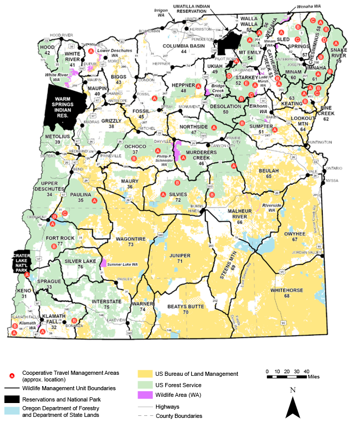
Beatys Butte #70
82% public lands. Beginning at Denio; west on Oregon state line to Fort Bidwell-Warner Valley Rd (Lake Co Rd 3-14); north on 3-14 to Adel; north on Co Rd 3-10 through Plush to Co Rd 3-11; east on 3-11 to Hart Refuge and Co Rd 3-12; north and east on 3-12 to Hart Refuge headquarters; east on Hart Mtn-Frenchglen Rd (Lake Co Rd 3-12 and Harney Co Rd 412) to Catlow Valley Rd (Harney Co Rd 202); south and east on Catlow Valley Rd to Harney Co Rd 201, 1 mi north of Fields; south on Co Rd 201 through Fields to Denio, point of beginning. Specific hunts do not include Hart Mtn NAR. (Maps: Lakeview/Burns BLM)
Beulah #65
57% public lands. Beginning at Vale; southwest on US Hwy 20 to Drewsey-Prairie City Rd near Drewsey; northwest on Drewsey-Prairie City Rd and FR 1663 to the junction with FR 14 near Antelope Mtn; northwest on FR 14 and FR 16 to Summit Prairie; north on Co Rd 62 to US Hwy 26; east on Hwy 26 to Ironside; east on Willow Creek Rd to Huntington Junction; east on Huntington Junction Rd/Malheur Line Rd (Durbin Creek), to I-84; southeast on I-84 to Birch Cr near Farewell Bend; east on Birch Cr to Snake Rvr; southeast along Snake Rvr to Nyssa; north on Hwy 201 to Cairo Junction; and west on US Hwy 20 to Vale, point of beginning. (Maps: Vale/Burns BLM, Malheur/Wallowa-Whitman NF)
Biggs #43
11% public lands. Beginning at Arlington; south on State Hwy 19 to Fossil; southwest on State Hwy 218 to Shaniko; north on US Hwy 97 to Grass Valley; southwest on State Hwy 216 to Tygh Valley; north on US Hwy 197 to Columbia Rvr; east on Columbia Rvr to Arlington, point of beginning. (Maps: Prineville BLM)
Catherine Cr #53
24% public lands. Beginning at Elgin; northeast on State Hwy 82 to Minam; south on Minam Rvr to Wallowa-Whitman NF boundary; west on forest boundary to Point Prominence Rd (62 and 6220); south on Point Prominence Rd to Moss Springs Campground; south and east from Moss Springs Campground on Lodgepole Trail 1920 to Cartwheel Ridge Trail 1907; north and east on Cartwheel Ridge Trail 1907 to the divide between Catherine Cr and Minam Rvr drainages and south to Meadow Mtn; generally southeast on the divide between Catherine Cr and the Minam Rvr drainages past Burger Butte to Granite Butte; generally south on the divide between Catherine Cr and Eagle Cr drainages to Flagstaff Butte; west on FR 7700582 to FR 77; west on FR 77 to FR 7740; south on 7740 to 7740050; south and west on 7740050 to Big Cr; south along Big Cr to FR 67; west on FR Rd 67 to Big Cr Rd 71; southwest and northwest on Big Cr Rd 71 to Medical Springs; southwest on State Hwy 203 to Powder Rvr; northwest on Powder Rvr to I-84 at N Powder; north on I-84 to State Hwy 82 at La Grande; northeast on Hwy 82 to Elgin, point of beginning. (Maps: Wallowa-Whitman NF, Vale BLM, ODF)
Chesnimnus #58
48% public lands. Beginning at Joseph; north on State Hwy 82 to Crow Cr Rd; north on Crow Cr Rd to Chesnimnus Cr; northwest on Chesnimnus Cr to Joseph Cr; northeast on Joseph Cr to Oregon-Washington state line; east and southeast along state line to Snake Rvr; southeast on Snake Rvr to mouth of Imnaha Rvr; southwest on Imnaha Rvr to Imnaha; southwest on Imnaha Hwy to Joseph, point of beginning. (Maps: Wallowa-Whitman NF, Vale BLM)
Columbia Basin #44
5% public lands. Beginning at Condon; north on State Hwy 19 to Oregon-Washington state line at Arlington; northeast on state line to State Hwy 11; southwest on Hwy 11 to Pendleton; southwest on US Hwy 395 to State Hwy 74; southwest on Hwy 74 to Heppner; southwest on State Hwy 207 to State Hwy 206; west on Hwy 206 to Condon, point of beginning. (Co maps)
Desolation #50
87% public lands. Beginning at Dale on US Hwy 395; southeast on N Fork John Day Rvr to Big Cr; northeast on Big Cr to Meadow Cr; northeast on Meadow Cr to FR 5225 at Forks Guard Station; northwest on 5225 to Granite-Ukiah Rd 52; southeast on Granite-Ukiah Rd 52 to Anthony Lks Rd 73; northeast on Anthony Lakes Rd to Summit of Blue Mtns west of Anthony Lakes; south along summit of Blue Mtns. to the Summit of Anthony Lakes Ski Area (junction of Grant, Baker, and Union counties); southwest on summit of Blue Mtns. (Baker/Grant county line) to Hwy 7; southwest along Hwy 7 to Co Rd 20; northwest on Co Rd 20 to US Hwy 395; north on Hwy 395 to Dale, point of beginning. (Maps: Umatilla National Forest, Malheur NF, Prineville BLM, ODF)
Fort Rock #77
65% public lands. Beginning at Silver Lake; west on State Hwy 31 to Klamath Marsh-Silver Lk Rd; west on Klamath Marsh Rd to Williamson Rvr; west and south on Williamson Rvr returning to Klamath Marsh Rd; west on Klamath Marsh Rd to US Hwy 97; west on Scott Cr Rd 66 one mi to Sand Cr; southwest on Sand Cr to Crater Lk NP boundary; north and west on Crater Lk NP boundary to Pacific Crest Trail; north on Pacific Crest Trail to State Hwy 58; southeast on Hwy 58 to Crescent Cr; north on Crescent Cr to Co Rd 61 to Crescent; east on Co Rd 61 to Crescent; north on Hwy 97 to Gilchrist main logging Rd one mi north of Gilchrist; east on Gilchrist main logging Rd 9775 to State Hwy 31 between milepost 16 and 17; southeast on Hwy 31 to Lk Co Rd 5-10 at Horse Ranch; 22 mi east and south on Lk Co Rd 5-10 to junction with Lk Co Rd 5-14; east on Lk Co Rd 5-14 to Lk Co Rd 5-14F at Christmas Valley; southwest on Lk Co Rd 5- 14F to State Hwy 31, 9 mi east of Silver Lake; west on Hwy 31 to Silver Lk, point of beginning. (Maps: Deschutes/ Winema/ Fremont NF, Lakeview BLM)
Fossil #45
16% public lands. Beginning at Fossil; north on Hwy 19 to Condon; east on State Hwy 206 to State Hwy 207; south on Hwy 207 to State Hwy 19; southeast on Hwy 19 to US Hwy 26; west on Hwy 26 to Bridge Cr near Mitchell; northwest on Bridge Cr to John Day Rvr; northwest on John Day Rvr to State Hwy 218 at Clarno; northeast on Hwy 218 to Fossil, point of beginning. (Maps: Umatilla NF, Prineville BLM, ODF)
Grizzly #38
28% public lands. Beginning at Redmond; north on US Hwy 97 to Crooked Rvr; north on Crooked Rvr and Deschutes Rvr to S Junction; northeast on S Junction Co Rd to Hwy 97 and US Hwy 197; south on Hwy 97 to Antelope Cr Rd; northeast on Antelope Cr Rd to Antelope; east on Hwy 218 to John Day Rvr at Clarno; southeast on John Day Rvr to Bridge Cr; southeast on Bridge Cr to US Hwy 26 near Mitchell; southwest on Hwy 26 to Prineville; west on US Hwy 126 to Redmond, point of beginning. (Maps: Ochoco NF, Prineville BLM)
Heppner #48
34% public lands. Beginning at Heppner; northeast on State Hwy 74 to US Hwy 395; south on Hwy 395 to Long Cr-Monument Rd; northwest on Long Cr-Monument Rd to N Fork John Day Rvr at Monument; southwest on N Fork John Day Rvr to State Hwy 19 at Kimberly; northwest on Hwy 19 to State Hwy 207; north on Hwy 207 to Heppner, point of beginning. (Maps: Umatilla NF, ODF)
Hood #42
65% public lands. Beginning at Hood Rvr; southwest on State Hwy 35 to Barlow Pass (Pacific Crest Trail); northwest on Pacific Crest Trail to Lolo Pass; northwest on Hood Rvr-Multnomah Co line to Columbia Rvr near Bonneville; east on Columbia Rvr to Hood Rvr, point of beginning. (Maps: Mt Hood NF)
Imnaha #61
74% public lands. Beginning at Joseph; northeast on Imnaha Hwy to Imnaha; south and west on Imnaha Rvr and S Fork of Imnaha Rvr to Hawkins Pass; north on W Fork Trail to Wallowa Lk; north on State Hwy 82 to Joseph, point of beginning. (Maps: Wallowa-Whitman NF)
Interstate #75
56% public lands. Beginning at Bly; west on State Hwy 140 to Beatty; north on Godowa Springs Rd to Sprague Rvr; west on Sprague Rvr one mi to Sycan Rvr; upstream north and east on Sycan Rvr to Pikes Crossing; east on FR 30 to FR 28; east on 28 to FR 29; east on 29 to State Hwy 31; southeast on Hwy 31 to Valley Falls; south on US Hwy 395 to Oregon-California state line; west on state line to Lost Rvr; northwest on Lost Rvr to East Langell Valley Rd; north on East Langell Valley Rd to Gerber Rd; northeast on Gerber Rd to Bly, point of beginning. (Maps: Fremont NF, Lakeview BLM)
Juniper #71
89% public lands. Beginning at Burns; east 2 mi on State Hwy 78 to State Hwy 205; south on Hwy 205 through Frenchglen to Hart Mtn Rd (Harney Co Rd 412 and Lake Co Rd 3-12); west on Hart Mtn Rd to Flagstaff Lk Rd (Lake Co Rd 3-11); west on Flagstaff Lk Rd to Hogback Rd (Lake Co Rd 3-10); northwest on Hogback Rd to US Hwy 395; northeast on Hwy 395 to US Hwy 20; east on Hwy 20 to Burns; point of beginning. Specific hunts do not include Hart Mtn NAR. (Maps: Lakeview/Burns BLM)
Keating #63
58% Public lands. Beginning at N Powder; northeast and southeast on Powder Rvr to State Hwy 203; northeast on Hwy 203 to Medical Springs; southeast and northeast on Big Cr Rd 71 and FR 67; north on Big Cr to FR 7740050; east and north on FR 7740050 to FR 7740 and to FR 77; east on 77 to Flagstaff Butte Rd 7700582; east on Rd 7700582 to Flagstaff Butte; north on the divide between Catherine Cr and Eagle Cr drainages to Granite Butte; east on summit of Eagle Mtns. to Hawkins pass; south to Jackson Peak; south to Krag Peak; south and east to Crater Lake; north and east to Red Mtn; north and east to Blue Cr Trail (1865) north of Cornucopia; south on Blue Cr trail to Pine Cr; south and east on Pine Cr to State Hwy 86; southwest on Hwy 86 to Old Richland-Halfway Hwy (Sag Rd); south on Sag Rd to Powder Rvr arm of Brownlee Reservoir; west on Powder Rvr to Hwy 86 near Goose Cr; west on Hwy 86 to I-84; north on I-84 to N Powder; point of beginning. (Maps Wallowa-Whitman NF; Vale BLM)
Keno #31
41% public lands. Beginning at Klamath Falls; south on US Hwy 97 to Oregon-California state line; west on state line to Copco Rd; north on Copco Rd to State Hwy 66; east on Hwy 66 to Jackson-Klamath Co line; north on Jackson-Klamath Co line to Dead Indian Rd; northeast on Dead Indian Rd to FR 3601; north on 3601 to State Hwy 140; east on Hwy 140 to FR 3661; north on 3661 to Fourmile Lk; northwest on Forest Trail 993 to Pacific Crest Trail; north on Pacific Crest Trail to south boundary of Crater Lk NP; east on south boundary of Crater Lk NP to State Hwy 62; southeast on Hwy 62 to Hwy 97; south on Hwy 97 to Klamath Falls, point of beginning. (Maps: Winema NF)
Klamath Falls #32
35% public lands. Beginning at Klamath Falls; north on US Hwy 97 to Williamson Rvr; north on Williamson Rvr to confluence of Sprague Rvr; east on Sprague Rvr to Godowa Springs Rd north of Beatty; south on Godowa Springs Rd to State Hwy 140 at Beatty; east on Hwy 140 to Bly; southwest on Gerber Rd to East Langell Valley Rd; south on East Langell Valley Rd to Lost Rvr; southeast on Lost Rvr to Oregon-California state line; west on state line to US Hwy 97; northeast on Hwy 97 to Klamath Falls, point of beginning. (Maps: Winema NF, Fremont NF)
Lookout Mtn #64
38% public lands. Beginning at junction of I-84 and State Hwy 86 northeast of Baker; east on Hwy 86 to Powder Rvr near Goose Cr; east on Powder Rvr to Snake Rvr; southwest on Snake Rvr to Birch Cr at Farewell Bend; west on Birch Cr to I-84; northwest on I-84 to Hwy 86, point of beginning. (Maps: Vale BLM, ODF)
Malheur Rvr #66
69% public lands. Beginning at Burns; north on US Hwy 395 to Seneca; east on Logan Valley Co Rd (FR 16) to FR 14; southeast on FR 14 to FR 1663 near Antelope Mtn; south on 1663 and Otis Valley Rd (Harney Co Rd 304) to Drewsey; south on Drewsey Rd (Harney Co Rd 305) to US Hwy 20; east on Hwy 20 to Harper; southwest on Harper-Follyfarm Rd (Malheur Co Rds 585 and 513) to state Hwy 78 near Follyfarm; northwest on State Hwy 78 to Burns, point of beginning. (Maps: Malheur NF, Burns and Vale BLM)
Maupin #40
9% public lands. Beginning at Maupin; north on US Hwy 197 to Tygh Valley; northeast on State Hwy 216 to Grass Valley; south on Hwy 97 to Shaniko; southeast on State Hwy 218 to Antelope; southwest on Antelope Cr Rd to Hwy 97; north on Hwy 97 to Hwy 197 and S Junction Rd; southwest on S Junction Rd to Deschutes Rvr at S Junction; northeast on Deschutes Rvr to Maupin, point of beginning. (Maps: Prineville BLM)
Maury #36
56% public lands. Beginning at Brothers on US Hwy 20; northwest on Hwy 20 to State Hwy 27; north on Hwy 27 to Prineville Dam; east on Prineville Reservoir, Crooked Rvr and Beaver Cr to Paulina; east on main Co Rd to Grindstone Cr Rd; southeast on Grindstone Cr Rd to Twelvemile Cr Rd; west on Twelvemile Cr Rd to Camp Cr-Glass Buttes Rd; south on Camp Cr-Glass Buttes Rd to US Hwy 20 near Glass Buttes; northwest on Hwy 20 to Brothers, point of beginning. (Maps: Ochoco NF, Prineville BLM)
Metolius #39
66% public lands. Beginning at Sisters; west on State Hwy 242 to Pacific Crest Trail; north on Pacific Crest Trail to to the junction of the “crest of the Cascades” with the Pacific Crest National Scenic Trail (PCT) in T11S R8E Sec 17; north on the Crest of the Cascades to the south boundary of Warm Springs Tribal Reservation; east on Warm Springs Tribal Reservation boundary following Jefferson Cr and Metolius Rvr to Lk Billy Chinook; south on Lk Billy Chinook to Crooked Rvr; southeast on Crooked Rvr to US Hwy 97; south on Hwy 97 to Redmond; west on State Hwy 126 to Sisters, point of beginning. (Maps: Deschutes NF, Prineville BLM)
Minam #60
74% public lands. Beginning at Minam; southeast on State Hwy 82 to head of Wallowa Lk; southwest on W Fork Trail to Hawkins Pass; southwest on summit of Eagle Mtns to Granite Butte; northwest on summit separating Big Minam and Catherine Cr drainages past Burger Butte and Meadow Mtn to Cartwheel Ridge Trail 1907; west on Cartwheel Ridge Trail to Lodgepole Trail 1920; north on Lodge Pole Trail to Moss Springs; north on Point Prominence Rd to boundary of Wallowa-Whitman NF; north and east on Forest boundary to Minam Rvr; north on Minam Rvr to Hwy 82 at Minam, point of beginning. (Maps: Wallowa-Whitman NF, Vale BLM)
Mt Emily #54
44% public lands. Beginning at Pendleton; northeast on State Hwy 11 to Weston; southeast on State Hwy 204 to Elgin; southwest on State Hwy 82 to I-84; northwest on I-84 to Pendleton, point of beginning. (Maps: Umatilla NF, Wallowa-Whitman NF, ODF)
Murderers Cr #46
65% public lands. Beginning at Dayville; east on US Hwy 26 to Prairie City; southeast on Co Rd 62 to Summit Prairie; west on Logan Valley Co Rd 16 to Seneca; south on US Hwy 395 to FR 37; southwest on 37 to FR 3750; west on 3750 to S Fork John Day Rvr; northwest on S Fork John Day Rvr to Dayville, point of beginning. (Maps: Malheur NF, Prineville BLM, ODF)
Northside #47
41% public lands. Beginning at John Day; northwest on US Hwy 26 to State Hwy 19; north on Hwy 19 to N Fork John Day Rvr at Kimberly; northeast on N Fork John Day Rvr to Long Cr Rd at Monument; southeast on Long Cr Rd to Long Cr; north on US Hwy 395 to Co Rd 20; southeast on Co Rd 20 to State Hwy 7; south on Hwy 7 to US Hwy 26; southwest on Hwy 26 to John Day, point of beginning. (Maps: Malheur NF, Prineville BLM, ODF)
Ochoco #37
54% public lands. Beginning at Prineville; northeast on US Hwy 26 to Dayville; south on S Fork John Day Rvr to Pine Cr Rd; west on Pine Cr Rd to Suplee; west on Co Rd to Paulina; west on Beaver Cr, Crooked Rvr and Prineville Reservoir to State Hwy 27 at Prineville Dam; northwest on Hwy 27 to Prineville, point of beginning. (Maps: Ochoco NF, Prineville BLM)
Owyhee #67
82% public lands. Beginning at Nyssa; south on Oregon-Idaho state line to Jordan Valley-Silver City Rd; west on Jordan Valley-Silver City Rd to Jordan Valley; southwest on US Hwy 95 to State Hwy 78; northwest on Hwy 78 to Follyfarm; northeast on Follyfarm-Harper Rd to Harper; east on US Hwy 20 to Cairo Junction, south on Hwy 20/26 to Nyssa, point of beginning. (Maps: Vale BLM)
Paulina #35
76% public lands. Beginning at Redmond; east on State Hwy 126 to Prineville; southeast on State Hwy 27 to US Hwy 20; northwest on Hwy 20 to Millican-Lk Rd 2-1/2 mi east of Millican; southeast and south on Millican-Lk Rd past Dickerson Well and Janes Well (Lk Co Rd 5-12D) to intersection of Lk Co Rd 5-12B; east on Lk Co Rd 5-12B to intersection of Lk Co Rd 5-14C; south on Lk Co Rd 5-14C to junction of Lk Co Rd 5-14; 2 mi east of Christmas Valley; west on Lk Co Rd 5-14 13 mi to junction with Lk Co Rd 5-10; 22 mi north and west on Lk Co Rd 5-10 to State Hwy 31; northwest on Hwy 31 to Gilchrist main logging Rd 9775 between MP 16 and 17; west on Gilchrist main logging Rd to US Hwy 97; northeast on Hwy 97 to Redmond, point of beginning. (Maps: Deschutes NF, Prineville/Lakeview BLM)
Pine Cr #62
76% public lands. Beginning at Cornucopia; north on Blue Cr trail (1865) to summit of Eagle Mtns; west and south on summit of Eagle Mtns to Red Mtn; west and south on summit of Eagle Mtns to Crater Lake; north and west on summit of Eagle Mtns to Krag Peak; north on summit of Eagle Mtns to Jackson Peak; north to Hawkins Pass; east and north on S Fork Imnaha Rvr and Imnaha Rvr to Dry Cr; southeast on Dry Cr and northeast on N Fork Dry Cr to Summit Rd; north and northeast on Summit Rd to Thirty-two Point Cr; east on Thirty-two Point Cr to Snake Rvr; south on Snake Rvr to mouth of Powder Rvr; west on Powder Rvr arm of Brownlee Reservoir to Old Richland-Halfway Hwy (Sag Rd); north on Sag Rd to Hwy 86; northeast on Hwy 86 to Pine Cr; northwest on Pine Cr to Cornucopia, point of beginning. (Maps: Wallowa-Whitman NF, Vale BLM, ODF)
Silver Lake #76
60% public lands. Beginning at Silver Lk; southeast on State Hwy 31 to FR 29; west on 29 to FR 28; west on 28 to FR 30; west on 30 to Pikes Crossing; downstream north and southwest on Sycan Rvr to Powers Crossing (Teddy Powers Meadow); northwest on Rd 44 to Yamsey Guard Station at head of Williamson Rvr; north and west on Williamson Rvr to Klamath Marsh-Silver Lk Rd; east on Klamath Marsh Rd through Bear Flat to Hwy 31; east on Hwy 31 to Silver Lake, point of beginning. (Maps: Winema NF, Fremont NF, Lakeview BLM)
Silvies #72
67% public lands. Beginning at Burns; west on US Hwy 20 to Glass Buttes-Camp Cr Rd near Glass Buttes; north on Glass Buttes-Camp Cr Rd to Twelvemile Cr Rd; east on Twelvemile Cr Rd to Grindstone Cr Rd; northeast on Grindstone Cr Rd to Paulina-Suplee Rd; southeast on Paulina-Suplee Rd to Suplee; east on Pine Cr Rd to S Fork John Day Rvr; southeast on S Fork John Day Rvr to FR 3750 at Bear Cr; east on 3750 to FR 37; northeast on 37 to US Hwy 395; south on Hwy 395 to Burns, point of beginning. (Maps: Ochoco NF, Malheur NF, Burns BLM)
Sled Springs #57
21% public lands. Beginning at Wallowa; west on State Hwy 82 to Elgin; northeast on Grande Ronde Rvr to Oregon-Washington state line; east along state line to Joseph Cr; southwest on Joseph Cr to Chesnimnus Cr; southeast on Chesnimnus Cr to Crow Cr Rd; south on Crow Cr Rd to Hwy 82; northwest on Hwy 82 to Wallowa, point of beginning. (Maps: Wallowa-Whitman NF, Vale BLM, ODF)
Snake Rvr #59
92% public lands. Beginning at confluence of Imnaha and Snake Rvr; southeast on Snake Rvr to Thirty-two Point Cr; southwest on Thirty-two Point Cr to Summit Rd; southwest and northwest on Summit Rd to N Fork Dry Cr; southwest on N Fork Dry Cr and northwest on Dry Cr to Imnaha Rvr; north on Imnaha Rvr to Snake Rvr, point of beginning. (Maps: Wallowa-Whitman NF)
Sprague #33
72% public lands. Beginning at Chiloquin; south on Williamson Rvr to US Hwy 97; north on Hwy 97 to State Hwy 62; northwest on Hwy 62 to Crater Lk NP boundary; east and north on Crater Lk NP boundary to Sand Cr; east on Sand Cr to Scott Cr Rd 66; east on Scott Cr Rd one mi to Hwy 97; east on Klamath Marsh-Silver Lk Rd to Williamson Rvr; upstream north, east and south on Williamson Rvr to Yamsey Guard Station; southeast on FR 44 to Sycan Rvr at Powers Crossing; south on Sycan Rvr to Sprague Rvr; west on Sprague Rvr to Williamson Rvr at Chiloquin, point of beginning. (Maps: Winema NF)
Starkey #52
67% public lands. Beginning on I-84 at State Hwy 82 at La Grande; southeast on I-84 to North Powder; west on N Powder Rvr Ln to Ellis Rd; south on Ellis Rd to Anthony Lks Rd; west on Anthony Lks Rd 73 to Anthony Lks; west past Anthony Lks to Granite-Ukiah Rd 52; northwest on Granite-Ukiah Rd 52 to Tower Mtn Rd 5226; east and north on Tower Mtn Rd 5226 past Tower Mtn and Frazier Forest Camp to State Hwy 244 (FR 59); east on Hwy 244 (FR 59) to FR 5900230 at Four Corners Forest Camp; north on Rd 5900230 to 2100040, north on Rd 2100040 to FR 21; north on 21 to FR 2135; northeast on 2135 to FR 2135400; northeast on FR 2135400 to Kamela; east on Summit Rd to I-84; southeast on I-84 to Hwy 82, point of beginning. (Maps: Wallowa-Whitman NF, Vale BLM, ODF)
Steens Mtn #69
64% public lands. Beginning at the junction of State Hwy 78 and State Hwy 205, 2 mi east of Burns; southeast on Hwy 78 to East Steens Rd (Harney Co Rd 201) near Follyfarm; southwest on East Steens Rd through Andrews to Catlow Valley Rd (Harney Co Rd 202) junction, 1 mi north of Fields; west and north on Catlow Valley Rd to Hwy 205 at Frenchglen; north on Hwy 205 to Hwy 78, point of beginning. (Maps: Burns BLM)
Sumpter #51
45% public lands. Beginning at Ironside; northwest on US Hwy 26 to Austin junction; northeast on State Hwy 7 to summit of Blue Mountains (Tipton Summit); northeast on Blue Mtn summit (Baker/Grant county line) to the Summit of Anthony Lks Ski Area (junction of Grant, Baker, and Union counties); north along the Blue Mtn summit to Anthony Lks Rd 73; northeast on Anthony Lks Rd to Ellis Rd; north on Ellis Rd to North Powder River Ln; east on North Powder River Ln to I-84 at North Powder; southeast on I-84 to Malheur Line Rd (Durbin Creek) overpass; west on Malheur Line Rd/Huntington Rd to Huntington Junction; west on Willow Creek Rd to Ironside, point of beginning. (Maps: Malheur NF, Wallowa-Whitman NF, Vale BLM, ODF)
Ukiah #49
35% public lands. Beginning at Pendleton; southeast on I-84 to Mt Emily exit; west on Co Rd to Kamela; southwest on FR 2135400 to FR 2135; southwest on 2135 to FR 21; southwest on 21 to 2100040, south on 2100040 to FR 5900230; south on 5900230 to State Hwy 244 ( FR 59) at Four Corners Forest Camp; west on Hwy 244 (FR 59) approximately 2 mi to Tower Mtn Rd 5226; south and east on Tower Mtn Rd 5226 past Frazier Forest Camp and Tower Mtn to Silver Butte Rd 5225; south on Silver Butte Rd 5225 to Meadow Cr; southwest on Meadow Cr to Big Cr; southwest on Big Cr to N Fork John Day Rvr; northwest on N Fork John Day Rvr to US Hwy 395; north on Hwy 395 to Pendleton, point of beginning. (Maps: Umatilla NF, Wallowa-Whitman NF, Vale BLM, ODF)
Upper Deschutes #34
75% public lands. Beginning at Bend; southwest on US Hwy 97 to Crescent; west on Klamath Co Rd 61 to Crescent Cr; southwest on Crescent Cr to State Hwy 58; northwest on Hwy 58 to Pacific Crest Trail; north on Pacific Crest Trail to US Hwy 242; east on Hwy 242 to Sisters; east on State Hwy 126 to Redmond; southwest on US Hwy 97 to Bend, point of beginning. (Maps: Deschutes NF)
Wagontire #73
85% public lands. Begin- ning on US Hwy 20, 2-1/2 mi east of Millican; southeast on Hwy 20 to US Hwy 395; southwest on Hwy 395 to State Hwy 31 at Valley Falls; northwest on Hwy 31 to Lk Co Rd 5-14F, 9 mi east of Silver Lk; northeast on Lk Co Rd 5-14F to Lk Co Rd 5-14 at Christmas Valley; east 2 mi on Lk Co Rd 5-14 to junction with Lk Co Rd 5-14C, 2 mi east of Christmas Valley; north and northeast on Lk Co Rd 5-14C to junction with Lk Co Rd 5-14D; continue north on Lk Co Rd 5-14C to intersection of Lk Co Rd 5-12B; west on Lk Co Rd 5-12B to Junction of Lk Co Rd 5-12D; north on Lk Co Rd 5-12D past Janes Well and Dickerson Well to Hwy 20, point of beginning. (Maps: Lakeview /Prineville/Vale BLM)
Walla Walla #55
33% public lands. Beginning at Weston; north on State Hwy 11 to Oregon-Washington state line; east on state line to FR 64; southwest on 64 to Tollgate; northwest on State Hwy 204 to Weston, point of beginning. (Only specific hunts include Mill Cr Watershed.) (Maps: Umatilla NF, Vale BLM, ODF)
Warner #74
70% public lands. Beginning at Lakeview; northeast on US Hwy 395 to Fort Bidwell-Warner Valley Rd north of Abert Lk; south on Fort Bidwell-Warner Valley Rd through Plush and Adel to Oregon-California state line; west on state line to Hwy 395; north on Hwy 395 to Lakeview, point of beginning. (Maps: Fremont NF, Lakeview BLM)
Wenaha #56
70% public lands. Beginning at Troy; southwest on Grande Ronde Rvr to Elgin; northwest on State Hwy 204 to Tollgate; northeast on FR 64 to Oregon-Washington state line; east on state line to Grande Ronde Rvr; southwest on Grande Ronde Rvr to Troy, point of beginning. (Maps: Umatilla NF, ODF)
Whitehorse #68
90% public lands. Beginning at Follyfarm; southeast on State Hwy 78 to US Hwy 95; northeast on Hwy 95 to Jordan Valley; east on Jordan Valley-Silver City Rd to Oregon-Idaho state line; south on Oregon-Idaho state line to the Oregon-Nevada state line; west on the Oregon-Nevada state line to Denio; northeast on Co Rd 201 through Fields and Andrews to Follyfarm, point of beginning. (Maps: Burns/Vale BLM)
White Rvr #41
43% public lands. Beginning at The Dalles; east on Columbia Rvr to US Hwy 197; south on Hwy 197 to Deschutes Rvr at Maupin; south on Deschutes Rvr to north boundary of Warm Springs Tribal Reservation boundary; west on northern Warm Springs Tribal Reservation boundary (McQuinn Strip line) to Hwy 216 and Hwy 26; northwest on Hwy 26 to Hwy 35; northeast on Hwy 35 to Hood Rvr; east on Columbia Rvr to The Dalles; point of beginning. (The McQuinn Strip portion of White Rvr Unit and Warm Springs Tribal Reservation was closed to public hunting Sept. 21, 1992 until further notice). (Maps: Mt Hood NF, Prineville BLM)