Skip to main content
Menu
Delaware
Fishing
Delaware
›
Fishing
›
Fishing & Clamming Maps
General Info
Fish Consumption Advisories
Youth Fishing & Tournament Info
Invasive Species
Artificial Reef Program
Sport Fishing Tournament
Sport Fishing Tournament Updates
State Record Holders
Access Point Angler Intercept Survey (APAIS)
Fishing Photo Contest Winners
A Message from the Director
Fish & Wildlife Directory
Licenses, Permits & Fees
License Fees
Fishing License Information
Tidal Regulations
Tidal Fishing Regulations
Tidal Seasons, Size & Creel Limits
Blue Crabs, Clams, Conchs & Oysters
Non-Tidal Regulations
Non-Tidal Fishing Regulations
Non-Tidal Season, Size & Creel Limits
Freshwater Trout Fishing
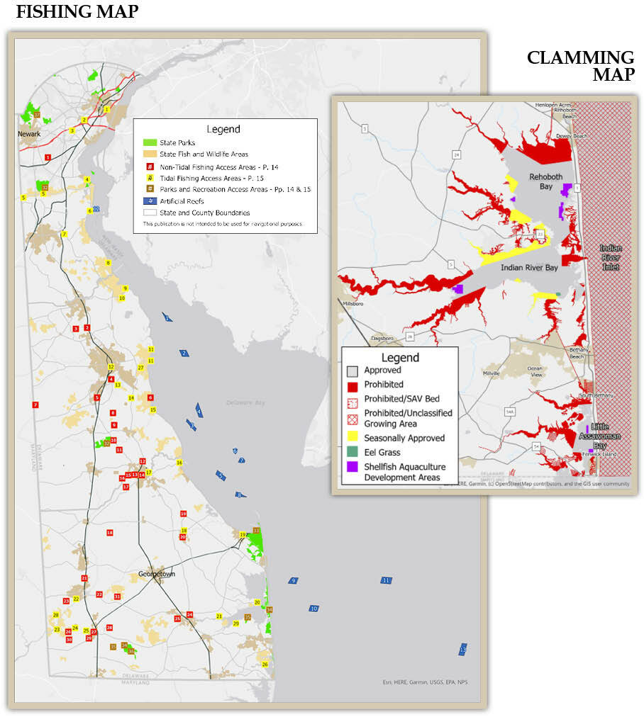
Fishing & Clamming Maps
Boating
Tidal Fishing Access Areas
Non-Tidal Fishing Access Areas
Boating Safety
Boat Ramp Certificate Sales
PDF Downloads
Circle Hooks for Striped Bass
Ethical Shark Fishing Practices
Fishing & Clamming Maps
Delaware
General Info
Fish Consumption Advisories
Youth Fishing & Tournament Info
Invasive Species
Artificial Reef Program
Sport Fishing Tournament
Sport Fishing Tournament Updates
State Record Holders
Access Point Angler Intercept Survey (APAIS)
Fishing Photo Contest Winners
A Message from the Director
Fish & Wildlife Directory
Licenses, Permits & Fees
License Fees
Fishing License Information
Tidal Regulations
Tidal Fishing Regulations
Tidal Seasons, Size & Creel Limits
Blue Crabs, Clams, Conchs & Oysters
Non-Tidal Regulations
Non-Tidal Fishing Regulations
Non-Tidal Season, Size & Creel Limits
Freshwater Trout Fishing
Fishing & Clamming Maps
Boating
Tidal Fishing Access Areas
Non-Tidal Fishing Access Areas
Boating Safety
Boat Ramp Certificate Sales
PDF Downloads
Circle Hooks for Striped Bass
Ethical Shark Fishing Practices