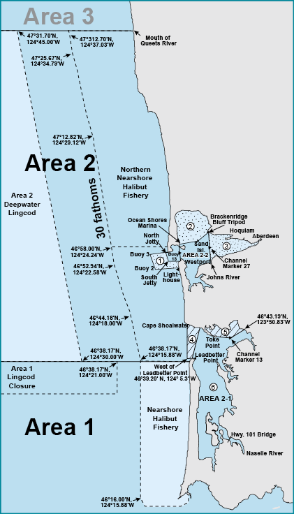
Marine Area 2
Marine Area 2-1 (Willapa Bay) and Marine Area 2-2 (Grays Harbor)
NOTE: In Areas 2-1 and 2-2, anglers may use either a freshwater, saltwater, or combination license.
Marine Area 2 Definition: from Leadbetter Point north to the Queets River, excluding Willapa Bay and Grays Harbor
Marine Area 2-1 (Willapa Bay) Definition: east of a line from Leadbetter Point (46°39.20' N, 124° 3.516' W) due west to 46°39.20' N, 124° 5.3' W then due north to the westerly most landfall on Cape Shoalwater (46°44.66' N, 124° 5.3' W)
Marine Area 2-2 (Grays Harbor) Definition: east of a line from the tip of the north jetty to exposed end of the south jetty
30 Fathom Lingcod Depth Restriction
Waters from Queets River south to Leadbetter Pt., as described by the following coordinates:
47°31.70'N, 124°37.03'W,
47°25.67'N, 124°34.79'W,
47°12.82'N, 124°29.12'W,
46°52.94'N, 124°22.58'W,
46°44.18'N, 124°18.00'W,
46°38.17'N, 124°15.88'W
Buoy 13 Line: A line drawn true north-south through Buoy 13 near the entrance of Grays Harbor.
Westport Boat Basin: A portion of Grays Harbor lying inside the boat basin breakwater and inside lines drawn from lighted day markers 10 to 11 and 1 to 2.
Northern Nearshore Halibut Fishery: This area includes the waters from 47°31.70’ N. latitude south to 46°58.00’N. latitude and east of a line approximating 30 fathoms as defined by the following coordinates:
47°31.70’N, 124°37.03’W,
47°25.67’N, 124°34.79’W,
47°12.82’N, 124°29.12’W,
46°58.00’N, 124°24.24’W.
Check the WDFW website at:
1 Grays Harbor Control Zone: An area at the entrance to Grays Harbor bounded by a line from the lighthouse 1 mile south of the south jetty to buoy #2 to buoy #3 to the tip of the north jetty to the tip of the exposed end of the south jetty.
2 Humptulips North Bay Fishery: Northerly of a line running from the south end of the eastern jetty at Ocean Shores Marina, then to a fishing boundary marker on Sand Island (46°57.52’N, 124°03.36’W) then to the Tripod Station located at 46°59.12’N, 124°00.72’W on Brackenridge Bluff.
3 East Grays Harbor Fishery: Easterly of a projected line from the mouth of Johns River (Hwy. 105 Bridge) to the Tripod Station on Brackenridge Bluff (46°59.12’N, 124°00.72’W) through channel marker 27 (green). Does not include the Johns River channel from the Hwy. 105 Bridge to the Coast Seafood dock north of Ocean Spray Cranberry plant.
4 Willapa Bay Control Zone: Waters from Leadbetter Point (46°39.20’ N, 124° 3.516’ W) due west to 46°39.20’ N,124° 5.3’ W then due north to the westerly most landfall on Cape Shoalwater (46°44.66’ N, 124° 5.3’ W) and from Leadbetter Point (46°39.20’ N, 124° 3.516’ W) through green marker 11 to landfall.
5 North River Closure: Waters north of a line from Toke Point channel marker 3 easterly through Willapa Harbor channel marker 13 (green) northeasterly to the power transmission pole located at 46°43.19’N, 123°50.83’W.
6 Marine Area 2-1 (Willapa Bay) Definition: waters east of a line from Leadbetter Point (46°39.20’ N, 124° 3.516’ W) due west to 46°39.20’ N, 124° 5.3’ W then due north to the westerly most landfall on Cape Shoalwater (46°44.66’ N, 124° 5.3’ W).
NOTE: In Areas 2-1 and 2-2, anglers may use either a freshwater, saltwater, or combination license.
Species |
Season |
Additional Rules |
Trout |
Year-round |
Catch-and-release |
Steelhead |
Year-round |
Daily limit 2 hatchery steelhead. |
Sturgeon |
Year-round |
Catch-and-release. |
Tuna and Mackerel |
Year-round |
No min. size. No daily limit except Northern bluefin, skipjack, and yellowfin tuna daily limit of 2 each. |
Herring, Sand Lance, and Smelt |
Year-round |
No min. size. Daily limit 10 lbs., all species combined. All smelt caught must be kept and count toward the daily limit except Closed to eulachon (Columbia River smelt). |
Anchovy and Sardine |
Year-round |
No min. size. Daily limit 25 lbs., all species combined. May be taken by a cast net. |
Pacific Halibut |
Check the WDFW website at https://wdfw.wa.gov/fishing/regulations/halibut or call (360) 902-2700 in April for information on Pacific halibut seasons and regulations. No min. size. Daily limit 1. Annual limit 4. See the Nearshore Halibut Fishery . Descending device required onboard vessels. |
|
Other Food Fish |
Year-round |
No min. size. Daily limit 2 of each species. See Definitions. |
All Other Fish |
CLOSED |
CLOSED to fishing for, retaining, or possessing. |
Salmon |
||
| Area 2 including the Grays Harbor Control Zone. (See 1 ) | June 24-Sept. 30, 2023 |
Chinook - min. size 22”. Coho - min. size 16”. Other salmon species - no min. size. Daily limit 2 including no more than 1 Chinook. Release wild coho. |
May-June, 2024 |
Check the WDFW website at |
|
| Area 2-1 (see map previous page) including Willapa Bay Control Zone (See 4 ). See exception for North River Area below (See 5 ). | June 24-July 31, 2023 |
Chinook - min. size 22”. Coho - min. size 16”. Other salmon species - no min. size. Daily limit 2 including no more than 1 Chinook. Release wild coho. |
Aug. 1-Jan. 31 |
Min. size 12”. Daily limit 6 including no more than 2 adults. Release wild Chinook. Anglers may fish with two poles with Two-Pole Endorsement. |
|
| North River Area (See 5 ) | June 24-July 31, 2023 |
Chinook - min. size 22”. Coho - min. size 16”. Other salmon species - no min. size. Daily limit 2 including no more than 1 Chinook. Release wild coho. |
Aug. 1-Sept. 30 |
CLOSED. |
|
Oct. 1-Jan. 31 |
Min. size 12”. Daily limit 6 including no more than 2 adults. Release wild Chinook. Anglers may fish with two poles with Two-Pole Endorsement. |
|
Area 2-2 (west of Buoy 13 line) |
June 24-Sept. 30, 2023 |
Chinook - min. size 22”. Coho - min. size 16”. Other salmon species - no min. size. Daily limit 2 including no more than 1 Chinook. Release wild coho. |
Area 2-2 (east of the Buoy 13 line) see exceptions for Humptulips North Bay, East Grays Harbor fisheries, Westport Boat and Ocean Shores Boat basins below |
Year-round. |
Closed except fisheries listed below. All salmon required to be released may not be totally removed from the water, except anglers fishing from boats 30’ or longer as listed on either their state or Coast Guard registration are exempt. |
| Humptulips North Bay Fishery (see 2) | Aug. 1-Sept. 15 |
Min. size 12”. Daily limit 1. Release wild Chinook and wild coho. |
| East Grays Harbor Fishery (see 3) | Sept. 16-Nov. 30 |
Min. size 12”. Daily limit 2. Release Chinook. |
Westport Boat Basin and Ocean Shores Boat Basin |
Aug. 16-Jan. 31 |
Min. size 12”. Daily limit 6 including no more than 4 adults. Release Chinook. Night closure and anti-snagging rule in effect except any hook where the weight is molded directly to the hook such as twitching jigs, swim jigs, or casting jigs are not allowed. Only single-point barbless hooks may be used. Record code 2-2W for Catch Record Card reporting. |
Bottomfish |
||
Second Sat. in Mar.-Third Sat. in Oct. |
Daily limit is a total of 9 bottomfish (see Definitions) except surfperch and flatfish. Subject to individual limits and seasons shown below. See 30 Fathom Lingcod Depth Restriction . Descending device required onboard vessels. |
|
Lingcod |
Second Sat. in Mar.-Apr. 30 |
Daily limit 2. No retention or possession seaward of a line drawn from, 47°31.70’ N, 124°45.00’ W to 46°38.17’ N, 124°30.00’ W (Area 2 Deepwater Lingcod). See map previous page. |
May 1-May 31 |
Daily limit 2. No retention or possession seaward of a line approximating 30 fathoms (except when the primary halibut season is open). See 30 Fathom Lingcod Depth Restriction . |
|
June 1-June 15 |
Daily limit 2. |
|
June 16-Aug. 31 |
Daily limit 2. No retention or possession seaward of a line drawn from, 47°31.70’ N, 124°45.00’ W to 46°38.17’ N, 124°30.00’ W (Area 2 Deepwater Lingcod) except when the primary halibut season is open. See map previous page. |
|
Sept. 1-Sept. 30 |
Daily limit 2. |
|
Oct. 1-Third Sat. in Oct. |
Daily limit 2. No retention or possession seaward of a line drawn from, 47°31.70’ N, 124°45.00’ W to 46°38.17’ N, 124°30.00’ W (Area 2 Deepwater Lingcod). See map previous page. |
|
Surfperch |
Second Sat. in Mar.-Third Sat. in Oct.Year-round from beach |
Not included in bottomfish limit. No min. size. Daily limit 12 surfperch. Except shiner perch daily limit 15: not included in bottomfish limit. |
Rockfish |
Second Sat. in Mar.-Apr. 30 |
No min. size. Daily limit 7. Release yelloweye. |
May 1-July 31 |
No min. size. Daily limit 7. Release yelloweye, copper, quillback and vermilion. |
|
Aug. 1-Third Sat. in Oct. |
No min. size. Daily limit 7. Release yelloweye. |
|
Cabezon |
Second Sat. in Mar.-Third Sat. in Oct. |
No min. size. Daily limit 1. |
Flatfish (Dabs, Sole, Flounder) |
Second Sat. in Mar.-Third Sat. in Oct. |
No min. size. In addition to the 9 bottomfish daily limit, 5 additional flatfish may be retained. |
Sixgill, Sevengill, and Thresher Sharks |
CLOSED |
CLOSED to fishing for, retaining, or possessing. Sixgill shark may not be removed from the water. |