Catch Record Cards & Codes
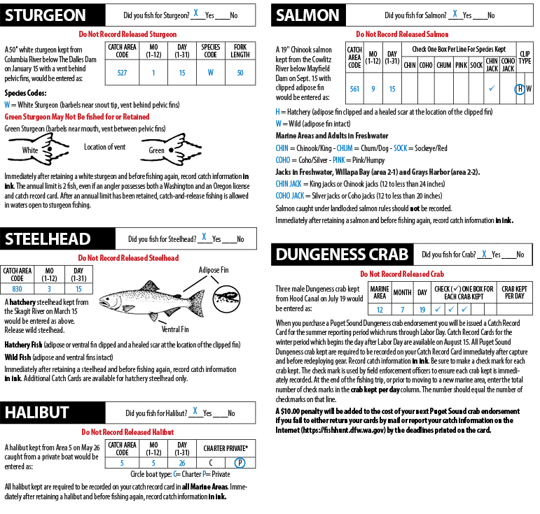
The Catch Record Card is an important management tool for estimating the recreational catch of sturgeon, steelhead, salmon, halibut, and Puget Sound Dungeness crab. A catch record card must be in your possession to fish for these species. Washington Administrative Code (WAC 220-56-175, WAC 220-69-236) requires all kept sturgeon, steelhead, salmon, halibut, and Puget Sound Dungeness crab to be recorded on your Catch Record Card, and requires all anglers to return their fish Catch Record Card by April 30, or for Dungeness crab by the date indicated on the card, even if nothing is caught or you did not fish. Please use the instruction sheet issued with your card. Please return Catch Record Cards to: WDFW CRC Unit, PO Box 43142, Olympia WA 98504-3142. Use examples below to help complete your card correctly. Do Not Record Released Catch. For Catch Record Card Information call (360) 902-2707.
For catch area codes, refer to the next page or the instruction sheet received with your catch record card, or refer to the Westside and Eastside rivers special rules sections within this pamphlet.
Immediately after retaining the species below and before fishing again, record catch information in ink.
Puget Sound Region
824 - Baker River
825 - Baker Lake
784 - Berry Creek
812 - Big Quilcene River
748 - Big Soos Creek
708 - Burley Creek (Kitsap Co.)
710 - California Creek
866 - Canyon Creek (Stillaguamish Sys.)
727 - Capitol Lake
802 - Carbon River
826 - Cascade River
714 - Chambers Creek
718 - Clallam River
722 - Curley Creek (Kitsap Co.)
724 - Dakota Creek (Whatcom Co.)
726 - Deep Creek (Clallam Co.)
728 - Deschutes River
732 - Dewatto River
734 - Dosewallips River
736 - Duckabush River
738 - Dungeness River
746 - Green/Duwamish River (King Co.)
752 - Hoko River
754 - Kennedy Creek
763 - Lake Sammamish
762 - Lake Washington
766 - Little Quilcene River
768 - Lyre River
770 - McAllister Creek (Thurston Co.)
778 - Minter Creek (Pierce/Kitsap Co.)
782 - Morse Creek (Clallam Co.)
786 - Nisqually River
794 - Nooksack River (below North Fork)
790 - Nooksack River, North Fork
788 - Nooksack River, Middle Fork
792 - Nooksack River, South Fork
870 - Pilchuck Creek (Stillaguamish Sys.)
840 - Pilchuck River (Snohomish Sys.)
804 - Puyallup River
810 - Pysht River
812 - Quilcene River (Big Quilcene River)
842 - Raging River
814 - Salt Creek (Clallam Co.)
816 - Samish River
828 - Sauk River
818 - Sekiu River
830 - Skagit River
834 - Skokomish River (Mason Co.)
844 - Skykomish River (below forks)
846 - Skykomish River, North Fork
848 - Skykomish River, South Fork
850 - Snohomish River
852 - Snoqualmie River
748 - Soos Creek (Big Soos Creek)
876 - Stillaguamish River (below forks)
872 - Stillaguamish River, North Fork
874 - Stillaguamish River, South Fork
832 - Suiattle River
854 - Sultan River
878 - Tahuya River
856 - Tokul Creek
858 - Tolt River
880 - Union River
860 - Wallace River
884 - Whatcom Creek
808 - White (Stuck) River
862 - Woods Creek
Columbia River Region
501 - Abernathy Creek
508 - Big White Salmon River
520 - Blind/Knappa Slough
507 - Blue Creek (Lewis Co.)
524 - Camas Slough
609 - Cedar Creek (Clark Co.)
552 - Chelan River
515 - Chinook River
555 - Cispus River
517 - Coal Creek (Cowlitz Co.)
519 - Columbia R. Buoy 10 to Rocky Pt.-Tongue Pt. line
521 - Columbia R. Rocky Pt.-Tongue Pt. line to Longview Br.
523 - Columbia R. Longview Br. to I-5 Br.
525 - Columbia R. I-5 Br. to Bonneville Dam
527 - Columbia R. Bonneville to The Dalles Dam
529 - Columbia R. The Dalles to John Day Dam
531 - Columbia R. John Day to McNary Dam
533 - Columbia R. McNary Dam to Hwy. 395 Br. at Pasco
534 - Columbia R. Hwy. 395 Br. to I-182 Br.
535 - Columbia R. I-182 Br. to Old Hanford townsite towers
536 - Columbia R. Old Hanford townsite towers to Priest Rapids
537 - Columbia R. Priest Rapids to Wanapum Dam
539 - Columbia R. Wanapum to Rock Island Dam
541 - Columbia R. Rock Island to Rocky Reach Dam
543 - Columbia R. Rocky Reach to Wells Dam
545 - Columbia R. Wells to Chief Joseph Dam
557 - Coweeman River
561 - Cowlitz R. below Mayfield Dam
559 - Cowlitz R. above Cowlitz Falls Dam and Lake Scanewa
580 - Deep River (Wahkiakum Co.)
568 - Delameter Creek
618 - Drano Lake
583 - Elochoman River mouth to Foster Rd. Bridge
584 - Elochoman River Foster Rd. Bridge to West Fork
586 - Entiat River
589 - Germany Creek
556 - Goble Creek
592 - Grande Ronde River
594 - Grays River mouth to Barr Rd. Bridge
595 - Grays River Barr Rd. Bridge to South Fork
596 - Grays River, West Fork
597 - Grays River, East Fork
565 - Green R. (Cowlitz Co.) mouth to Toutle Hatchery rack site
566 - Green R. (Cowlitz Co.) Toutle Hatchery rack site upstream
598 - Hamilton Creek
672 - Icicle River (Creek)
604 - Kalama River mouth to Modrow Bridge
603 - Kalama River Modrow Bridge to upper salmon hatchery
602 - Kalama River upper salmon hatchery upstream
607 - Klickitat River below #5 fishway
608 - Klickitat River above #5 fishway
567 - Lacamas Creek (Lewis Co.)
559 - Lake Scanewa (Reservoir)
670 - Lake Wenatchee
611 - Lewis River (below East Fork)
613 - Lewis River, East Fork
615 - Lewis River, North Fork
661 - Little Washougal River
563 - Mayfield Lake (Reservoir)
621 - Methow River
624 - Mill Creek (Cowlitz Co.)
625 - Mill Creek (Lewis Co.)
627 - Okanogan River
569 - Olequa Creek (Lewis Co.)
652 - Palouse River (Whitman Co.)
632 - Rock Creek (Skamania Co.)
549 - Roosevelt Lake (Lake Roosevelt)
635 - Salmon Creek (Clark Co.)
629 - Similkameen River
638 - Skamokawa Creek
640 - Snake R. below Ice Harbor Dam
642 - Snake R. Ice Harbor to Lower Monumental Dam
644 - Snake R. Lower Monumental to Little Goose Dam
646 - Snake R. Little Goose to Lower Granite Dam
648 - Snake R. Lower Granite to WA/ID state line, Clarkston
650 - Snake R. upstream of the WA/ID state line, Clarkston
571 - Tilton River
657 - Touchet River
573 - Toutle River (below forks)
575 - Toutle River, No. Fork
577 - Toutle River, So. Fork
653 - Tucannon River
659 - Walla Walla River
667 - Washougal River mouth to WDFW Co. Line Access Site
668 - Washougal River WDFW Co. Line Access Site upstream
665 - Washougal River, North and West Forks
674 - Wenatchee River
677 - Wind River above Shipherd Falls
679 - Wind River Hwy. 14 to Shipherd Falls
680 - Wind River mouth to Hwy. 14
690 - Yakima River
Coastal Region
305 - Bear River (Pacific Co.)
386 - Big River (Clallam Co.)
706 - Black River (Grays Harbor/
Thurston Co.)
398 - Bogachiel River
400 - Calawah River
308 - Cedar Creek (Grays Harbor Co.)
311 - Cedar Creek (Jefferson Co.)
312 - Cedar River (Pacific Co.)
317 - Chehalis R. below Black R.
315 - Chehalis R. above Black R.
319 - Chehalis River, South Fork
392 - Clearwater River
321 - Cloquallam Creek
408 - Cook Creek
339 - Copalis River
402 - Dickey River (Clallam Co.)
320 - Elk Creek (Lewis/Pacific Co.)
342 - Elk River (Grays Harbor Co.)
345 - Goodman Creek (Jefferson Co.)
350 - Hoh River below Oxbow Campground boat launch
348 - Hoh River above Oxbow Campground boat launch
352 - Hoh River, South Fork
355 - Hoquiam River
358 - Humptulips River (below forks)
361 - Humptulips River, East Fork
362 - Humptulips River, West Fork
323 - Joe Creek
367 - Johns River
369 - Kalaloch Creek
371 - Moclips River
373 - Mosquito Creek (Jefferson Co.)
375 - Naselle River
379 - Nemah River, North (below Nemah Hatchery), Middle, and South
378 - Nemah River, North (above Nemah Hatchery)
325 - Newaukum River
389 - Niawiakum River
382 - North River
388 - Ozette River
390 - Palix River
394 - Queets River
370 - Quigg Lake (Grays Harbor Co.)
404 - Quillayute River
327 - Quinault Lake
410 - Quinault R, Lower (below L. Quinault, not Cook Cr.)
412 - Quinault R, Upper (above L. Quinault)
414 - Raft River
377 - Salmon Creek (Pacific Co.)
396 - Salmon River (Jefferson Co.)
329 - Satsop River, below forks & East Fork
329A - Satsop River, (ADA site)
331 - Satsop River, Middle and West Forks
333 - Skookumchuck River
384 - Smith Creek (Pacific Co.)
406 - Sol Duc River
418 - Sooes River (Clallam Co.)
364 - Stevens Creek
419 - Van Winkle Creek (Grays Harbor Co.)
420 - Waatch River
424 - Willapa River
422 - Willapa River, South Fork
380 - Williams Creek
335 - Wishkah River
335A - Wishkah River (ADA site)
337 - Wynoochee River
Marine Area Codes
1 - Ilwaco
2 - Westport-Ocean Shores
2-1 - Willapa Bay
2-2 - Grays Harbor
2-2W - Westport Boat Basin
3 - La Push
4 - Neah Bay
5 - Sekiu and Pillar Point
6 - East Juan de Fuca Strait
7 - San Juan Islands
8-1 - Deception Pass, Hope Island, and Skagit Bay
8-2 - Ports Susan and Gardner
9 - Admiralty Inlet
10 - Seattle-Bremerton
11 - Tacoma-Vashon Island
12 - Hood Canal
13 - South Puget Sound
See map and descriptions in the Marine Section for area definitions.