Management Designations for Marine Areas
Oregon’s marine managed areas are classified based on site-specific management goals, including conservation, research, education, and recreational viewing. Sites may include the intertidal zone (areas between extreme high and low tide), subtidal zone (areas deeper than extreme low tide), or both.
Detailed maps and information on these sites are available at: www.odfw.com/marinemap
Site Classification:
Marine Reserve (MR)
Subtidal/intertidal areas dedicated to conservation and scientific research. No take of fish or invertebrates is allowed.
Marine Protected Area (MPA)
Subtidal/intertidal areas adjacent to Marine Reserves dedicated to conservation and scientific research. No take of fish or invertebrates is allowed; however, exceptions are noted.
Detailed information on Oregon’s MRs and MPAs can be found at: www.oregonmarinereserves.com
Marine Research Area (MRA)
Subtidal/intertidal areas with the goal of allowing for research while maintaining ecological integrity. Generally, these areas are closed to the take of invertebrates; however, there are exceptions at some areas for commonly harvested invertebrates. Angling is allowed in most areas.
Marine Conservation Area (MCA)
Areas with the goal of conserving the natural ecosystem by prohibiting the take of some or all invertebrates. Angling is allowed in most areas.
Marine Garden (MG)
Shoreline and intertidal areas with the goal of protecting rocky habitat and ecological integrity while promoting education and viewing. No take of invertebrates is allowed; however, single mussels (for bait) may be taken. Angling is allowed in most areas.
Shellfish Preserve
Research and conservation of bivalves, including clams.
Exceptions:
The following apply to marine management areas when noted with a red asterisk
* Single mussels may be taken (for bait).
** Clams, Dungeness crab, red rock crab, mussels, piddocks, scallops, and shrimp may be taken.
Seaweed Harvest
The harvest of marine algae and kelp are prohibited in most marine management areas. For harvest regulations, consult Oregon State Parks (intertidal) and Department of State Lands (subtidal).
Offshore Rocks
Offshore rocks are part of Oregon Islands National Wildlife Refuge and have protections for birds and mammals under the authority of United States Fish and Wildlife Service (USFWS). Public access on these offshore rocks is not allowed above the high tide line, boating restrictions may also apply seasonally.
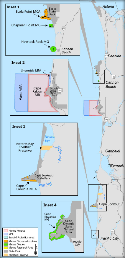
Ecola Point MCA (Inset 1)
No take of shellfish and other invertebrates in the intertidal*. Site boundary: Encompasses shoreline and ocean along the headland from 194 yards northeast of the tip of Bald Point to 176 yards north of Waterfall Creek to the south, encompassing beaches and nearshore rocks within the site polygon.
Chapman Point MG (Inset 1)
No take of shellfish and other invertebrates in the intertidal*. Site boundary: Encompasses shoreline around Chapman Pt, extending 194 yards north and 211 yards south of the tip of Chapman Point (perpendicular to West 7th St. beach access), encompasses ocean out to 405 yards from the tip of Chapman Point.
Haystack Rock MG (Inset 1)
No take of shellfish and other invertebrates in the intertidal*. Site Boundary: 300-yard radius around the base of Haystack Rock (Cannon Beach). Includes all tidepools and beach between extreme high and low tides.
Cape Falcon MR and MPA (Inset 2)
- MR: No take of fish or invertebrates.
- West MPA: No take of fish or invertebrates, except salmon (by troll) and crab.
- Shoreside MPA: No take of fish or invertebrates, except angling from shore is allowed.
- Intertidal Area: No take of fish or invertebrates south of shoreside MPA and within MR, except clams may be taken at Short Sand Beach.
Netarts Bay Shellfish Preserve (Inset 3)
No take of clams. Site boundary: Between an east-west line from the mouth of Whiskey Creek and an east-west line 900 yards south.
Cape Lookout MCA (Inset 3)
No take of shellfish and other invertebrates in the intertidal**. Site boundary: Begins on west-facing sand beach 880 yards north of Rover Creek, extending west along the Cape's south flank, around the tip, then east along the north flank for 1,425 yards.
Cape Kiwanda MG (Inset 4)
No take of shellfish and other invertebrates in the intertidal*. Site boundary: Intertidal between the north and south sides of Cape Kiwanda. Includes rocky areas abutting the sand beaches on the north and south sides of the headland.
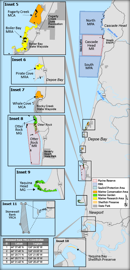
Cascade Head MR and MPA
- MR: No take of fish or invertebrates.
- North MPA: No take of fish or invertebrates, except crab, salmon (by troll), groundfish (by hook-and-line from private, non-chartered boat).
- West MPA: No take of fish or invertebrates, except salmon (by troll) and crab.
- South MPA: No use of net gear.
- Intertidal Area: No take of fish or invertebrates from Roads End Pt to northeastern North MPA boundary
Fogarty Creek MCA (Inset 5)
No take of shellfish and other invertebrates in the intertidal or subtidal zones. No take of fish from a boat. Site boundary: Intertidal and subtidal zones between the southern flank of Fishing Rock and the southern flank of the rocky platform located 180 yards south of Fogarty Creek. The seaward boundary is defined by coordinates:
44°50.405’N, 124°3.478’W, and 44°50.782’N, 124°3.208’W
Boiler Bay MRA (Inset 5)
No take of shellfish and other invertebrates**. Site boundary: Intertidal between the mouth of Fogarty Creek and the westermost tip of Government Point at Boiler Bay State Wayside.
Pirate Cove MRA (Inset 6)
No take of shellfish and other invertebrates below extreme high tide east of a line drawn across mouth of cove, defined by:
44°49.083’N, 124°04.035’W and 44°49.146’N, 124°04.06’W
Whale Cove MCA (Inset 7)
No take of fish, shellfish, and other invertebrates below extreme high tide east of a line drawn across mouth of cove, defined by:
44°47.237’N, 124°04.298’W, and 44°47.367’N, 124°04.32’W
Otter Rock MG (Inset 8)
No take of invertebrates*. Site boundary: Intertidal between the highest point at Cape Foulweather and Devils Punchbowl. Where MG overlaps Otter Rock MR, no take is allowed.
Otter Rock MR (Inset 8)
- MR: No take of fish or invertebrates.
- Intertidal Area: No take of fish or invertebrates from Gull Rock, south past Devils Punch Bowl State Park.
Yaquina Head MG (Inset 9)
No take of shellfish and other invertebrates*. Site boundary: Intertidal along the north and south sides of Yaquina Head. Includes rocky areas abutting the sandy beaches along the headland.
Yaquina Bay Shellfish Preserve (Inset 10)
No take of clams in posted shellfish preserve (tideflat on north side of Yaquina Bay commercial marina breakwater.)
Stonewall Bank Yelloweye Rockfish Conservation Area (Inset 11)
No take of Pacific halibut, lingcod, flatfish, or any other species from the groundfish group listed under General Marine Species section in the table on page 81.
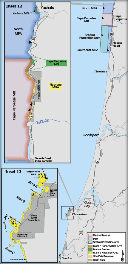
Yachats MG (Inset 12)
No take of shellfish and other invertebrates. Site boundary: Intertidal between the north and south boundaries of Yachats State Park.
Cape Perpetua MG (Inset 12)
No take of shellfish and other invertebrates, except razor clams may be taken in the sand beach that does not overlap with the MR. Site boundary: Intertidal between the north side of Devils Churn and the north boundary of Neptune State Park.
Neptune State Park MRA (Inset 12)
No take of shellfish and other invertebrates**. Site boundary: Intertidal between the northerly and southerly boundaries of Neptune State Park. No take of invertebrates where the site overlaps with Cape Perpetua MR.
Cape Perpetua MR and MPAs (Inset 12)
- MR: No take of fish or invertebrates.
- North MPA: No take of fish or invertebrates, except crab, salmon by troll, and angling from shore.
- Southeast MPA and Seabird
- Protection Area: No take of herring, sardine, anchovies, smelt, and sand lance. Also, no take of squid in the Southeast MPA.
- Intertidal Area:
- North MPA: No take of invertebrates, shore angling allowed.
- From Devils Churn to Gwynn Creek: No take of fish or invertebrates, except razor clams at Cape Perpetua MG.
- From Gwynn Creek to Cummins Creek: No take of fish or invertebrates**.
- From Cummins Creek to Bob Creek: No take of fish or invertebrates.
- From Bob Creek to Tenmile Creek: No shore angling, take of invertebrates is allowed
Gregory Point MRA (Inset 13)
No take of shellfish and other invertebrates in all areas below the extreme low tide line within the area bound by:
43°20.312’N, 124°22.838’W,
43°20.598’N, 124°22.895’W,
43°20.650’N, 124°22.637’W,
43°20.402’N, 124°22.545’W
Cape Arago MRA (Inset 13)
No take of shellfish and other invertebrates in Areas A and C. No take of invertebrates in Area B**. Site boundary: Intertidal in the following areas:
- Area A: Between a line projected due west from Cape Arago lighthouse and the southern tip of Norton Gulch.
- Area B: Between the southern tip of Norton Gulch and Simpson Reef overlook.
- Area C: Between Simpson Reef overlook and a point ¾ mi south of Cape Arago State Park.
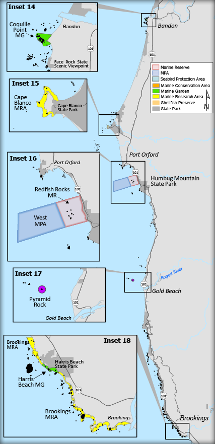
Coquille Point MG (Inset 14)
No take of shellfish and other invertebrates*. Site boundary: Intertidal between a line perpendicular to shore from the 8th Street beach access point and a line perpendicular to shore from the Coquille Point beach access staircase.
Cape Blanco MRA (Inset 15)
No take of shellfish and other invertebrates**. Site boundary: Intertidal along the north and south sides of the cape extending to encompass all rock along the headland up to the sand beaches of the north and south sides.
Redfish Rocks MR and MPA (Inset 16)
- MR: No take of fish or invertebrates.
- West MPA: No take of fish or invertebrates, except salmon (by troll) and Dungeness crab.
- Intertidal Area: Open to all legal take, such as clamming, above the low tide line.
Pyramid Rock (Rogue Reef) (Inset 17)
No take of fish or invertebrates from 333 yards around and including Pyramid Rock May 1-Aug 31.
Brookings MRA (Inset 18)
No take of shellfish and other invertebrates**. Site boundary: Intertidal between a point ½ mile north of Harris Beach State Park and the mouth of the Chetco River (except the area within the Harris Beach MG).
Harris Beach MG (Inset 18)
No take of shellfish and other invertebrates*. Site boundary: Between a line perpendicular to shore from the Harris Beach State Park beach access parking area and a line perpendicular to shore from the road entrance to Harris Beach State Park off of Hwy 101.