Wildlife Management Units
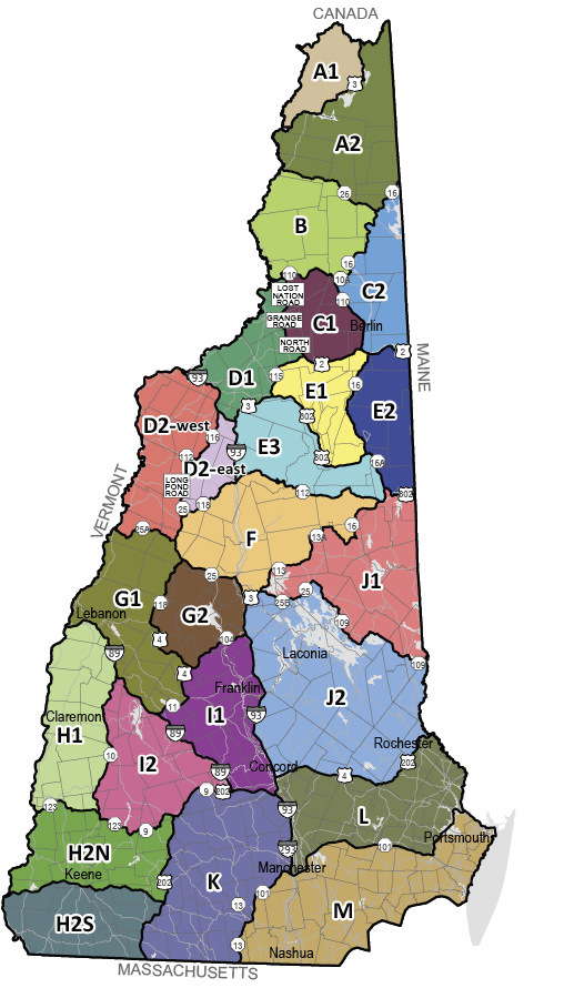
NOTE: Whenever a wildlife management unit (WMU) is referenced with only a letter, and that WMU has been divided into sub-wildlife management units with a number, or further divided into smaller units, the single letter reference includes all of the area enclosed by those sub-units. For example, WMU C would mean WMUs C1 and C2.
Unit A: From the Colebrook/Lemington bridge in Colebrook, north along the NH/VT state line to the NH/Quebec border, north along the U.S. border to NH/ME state line, south along the ME/NH state line to Rte. 16 in Wentworth’s Location, south on Rte. 16 to Rte. 26 in Errol, west on Rte. 26 to Rte. 3 in Colebrook, north on Rte. 3 to Lemington Rd. in Colebrook, west on Lemington Rd. to Colebrook/Lemington bridge & the NH/VT state line.
Unit B: From the junction of the Connecticut River and the Upper Ammonoosuc River in Northumberland, north along the NH/VT state line to the Colebrook/Lemington bridge in Colebrook, east on Lemington Rd. to Rte. 3 in Colebrook, south on Rte. 3 to Rte. 26 in Colebrook, east on Rte. 26 to Rte. 16 in Errol, south on Rte. 16 to Rte. 110-A in Dummer, west on Rte. 110-A to Rte. 110 in West Milan, west on Rte. 110 to Rte. 3 in Groveton, north on Rte. 3 in Groveton to the Upper Ammonoosuc Bridge, west along the Upper Ammonoosuc River to its junction with the Connecticut River.
Unit C1: From the junction of the Lost Nation Rd. in Northumberland and Rte. 110, east along Rte. 110 to Rte. 16 in Berlin, south on Rte. 16 to Rte. 2 in Gorham, west on Rte. 2 to North Rd. in Jefferson, north along North Rd. to Grange Rd., north on Grange Rd. to Lost Nation Rd., north on Lost Nation Rd. to the junction of Lost Nation Rd. and Rte. 110 in Northumberland.
Unit C2: From the junction of Rte. 16 in Wentworth's Location and the ME/NH line, south on Rte. 16 to Rte. 110-A in Dummer, west on Rte. 110-A to Rte. 110 in Milan, south on Rte. 110 to Rte.16 in Berlin, south on Rte. 16 to Rte. 2 in Gorham, east on Rte. 2 to the NH/ME state line, north on the NH/ME state line to its junction with Rte. 16 in Wentworth's Location.
Unit D1: From the junction of the Lost Nation Rd. in Northumberland & Rte. 110, south along Lost Nation Rd. to Grange Rd., south on Grange Rd. to North Rd., south on North Rd. to Rte. 2 in Jefferson, east on Rte. 2 to Rte. 115 in Jefferson, south on Rte. 115 to Rte. 3 in Carroll, south on Rte. 3 to I-93 in Franconia, north on I-93 to the NH/VT state line, north on the NH/VT state line, to the junction of the Connecticut and Upper Ammonoosuc River in Northumberland, east along the Upper Ammonoosuc River to the Groveton/Rte. 3 bridge, south along Rte. 3 in Groveton, east on Rte. 110 to the junction of Rte. 110 and the Lost Nation Rd.
Unit D2-west: From the junction of Rte. I-93 and the Vermont border in Littleton, south on I-93 to Rte. 142 in Franconia, south on Rte. 142 to Rte. 18, west on Rte. 18 to Rte. 116, south on Rte. 116 to Rte. 112 and Rte. 116, west on Rte. 116 to Long Pond Rd. (i.e., North/South Rd.) in Benton, south on Long Pond Rd. to High St. in Glencliff, south on High St. to Rte. 25, south on Rte. 25 to Rte. 25-A in Wentworth, west on Rte. 25-A to Rte. 10 in Orford, north on Rte. 10/ 25-A, then west on Rte. 25-A across the Fairlee Bridge, to the VT/NH border, then north on the VT/NH border to its intersection with Rte. I-93 in Littleton.
Unit D2-east: From the junction of Rte. I-93 and Rte. 142 in Franconia, south on Rte. I-93 to Rte. 112 in Woodstock, south west on Rte. 112 to Rte. 118 in Woodstock, south west on Rte. 118 to Rte. 25 in Warren, north on Rte. 25 to High St., north on High St. to Long Pond Rd. (i.e., North/South Rd.), north on Long Pond Rd. to Rte. 116 in Benton, north on Rte. 116 to Rte. 18 in Franconia, east on Rte. 18 to Rte. 142, north on Rte. 142 to the intersection with Rte. I-93.
Unit E: From the junction of Rte. 115 & Rte. 2 in Jefferson, east on Rte. 2 to NH/ME state line in Shelburne, south along the NH/ME state line to Rte. 302 in Conway, west on Rte. 302 to Rte. 16 in Conway, south on Rte. 16 to Rte. 112 in Conway, west on Rte. 112 to I-93 (exit 32) in Woodstock, north on I-93 to Rte. 3 (Franconia Notch) in Lincoln, north on Rte. 3 to Rte. 115 in Carroll, north on Rte. 115 to Rte. 2 in Jefferson.
Unit F: From the junction of Rte. 25-A & Rte. 25 in Wentworth, north on Rte. 25 to Rte. 118 in Warren, north on Rte. 118 to Rte. 112 in North Woodstock, east on Rte. 112 to Rte. 16 in Conway, south on Rte. 16 to Rte. 113 in Chocorua, west on Rte. 113 to Rte. 113-A in Tamworth, west on Rte. 113-A to Rte. 113 in North Sandwich, west on Rte. 113 to Rte. 3 in Holderness, south on Rte. 3 to Exit 24 of I-93, north on I-93 to Rte. 25 (exit 26) in Plymouth, west on Rte. 25 to the junction with Rte. 25-A in Wentworth.
Unit G1: From the junction of Rte. 25-A and the VT/NH border in Orford, east on Rte. 25-A to Rte. 10 in Orford, south on Rte. 10 to Rte. 25-A in Orford, east on Rte. 25-A to Rte. 25 in Wentworth, southeast on Rte. 25 to Rte. 118 in Rumney, south on Rte. 118 to Rte. 4 in Canaan, south and east on Rte. 4 to Rte. 11 in Andover, west on Rte. 11 to Rte. I-89 in New London, west on Rte. I-89 to the VT/NH border, north on the VT/NH border to its intersection with Rte. 25-A in Orford.
Unit G2: From the junction of Rte. 118 and Rte. 25 in Rumney, southeast on Rte. 25 to Exit 26 of Rte. I-93 in Plymouth, south on Rte. I-93 to Rte. 104 in New Hampton, west on Rte. 104 to Rte. 4 in Danbury, north on Rte. 4 to Rte. 118 in Canaan, north on Rte. 118 to Rte. 25 in Rumney.
Unit H1: From the junction of I-89 and the NH/VT state line in Lebanon, south on I-89 to Rte. 10 in Grantham, south on Rte. 10 to Rte. 123 in Marlow, west on Rte. 123 to its junction with the Cold River in Walpole, west on Cold River to the NH/VT border (Connecticut River), north on the NH/VT border to I-89 in Lebanon.
Unit H2: From the junction of Cold River and NH/VT border (Connecticut River) in Walpole, east on Cold River to Rte. 123, east on Rte. 123 to Rte. 9 in Stoddard, east on Rte. 9 to Rte. 202 in Hillsborough, south on Rte. 202 to the NH/MA border, west on the NH/MA border to the NH/VT border (Connecticut River), north on the NH/VT border (Connecticut River) to its intersection with the Cold River in Walpole.
Unit I1: From the junction of I-89 and Rte. 11 in New London, north on Rte. 11 to Rte. 4 in Andover, north on Rte. 4 to Rte. 104 in Danbury, north on Rte. 104 to I-93 in New Hampton, south on I-93 to I-89 in Concord, north on I-89 to Rte. 11 in New London.
Unit I2: From the junction of I-89 and Rte. 10 in Grantham, south on I-89 to Rte. 9 in Hopkinton, south on Rte. 9 to Rte. 123 in Stoddard, west on Rte. 123 to Rte. 10 in Marlow, north on Rte. 10 to I-89 in Grantham.
Unit J1: From the junction of Rte. 113 and Rte. 3 in Holderness, north on Rte. 113 to Rte. 113-A in Sandwich, north on Rte. 113-A to Rte. 113 in Tamworth, east on Rte. 113 to Rte. 16 in Chocorua, north on Rte. 16 to Rte. 302 in Conway, east on Rte. 302 to the ME/NH line, south on ME/NH line to Rte. 109 west on Rte. 109 to Rte. 28 in Wolfeboro Center, south on Rte. 28/109 to Rte. 109 in Wolfeboro, north on Rte. 109 to Rte. 25 in Moultonboro, west on Rte. 25 to Rte. 25B in Center Harbor, along Rte. 25B to Rte. 3, north on Rte. 3 to its junction with Rte. 113 in Holderness.
Unit J2: From the junction of Rte. I-93 and Rte. 3 in Ashland, south on Rte. 3 to Rte. 25B in Center Harbor, east on Rte. 25B to Rte. 25 in Center Harbor, east on Rte. 25 to Rte. 109 in Moultonboro, southeast on Rte. 109 to Rte. 28/109 in Wolfeboro, north on Rte. 28/109 to Rte. 109 in Wolfeboro Center, east on Rte. 109 to its intersection with the ME/NH border, south along the ME/NH border to Rte. 202 in Rochester, south on Rte. 202 to Rte. 4 in Northwood, west on Rte. 4 to I-393 in Pembroke, west on I-393 to I-93 in Concord, north on I-93 to the junction of Rte. 3 in Ashland.
Unit K: From the junction of Rte. 9 and Rte. 202 in Hillsborough, south on Rte. 202 to the NH/MA state line, east on the NH/MA state line to Rte. 13 in Brookline, north on Rte. 13 to Rte. 101 in Milford, north on Rte. 101 to I-293 in Manchester, north on I-293 to I-93, north on I-93 to I-89 in Concord, west on I-89 to Rte. 9 in Hopkinton, south on Rte. 9 to its junction with Rte. 202 in Hillsborough.
Unit L: From the junction of I-93 & I-393 in Concord, east on I-393 to Rte. 4, east on Rte. 4 to Rte. 202 in Northwood, north on Rte. 202 to NH/ME state line, south along the NH/ME state line to Little Bay, south along the Rockingham/Strafford County line in Little & Great Bay to the Squamscott River, south along the Squamscott River to Rte. 101, west along Rte. 101 to I-93 in Manchester, south on I-93 to I-293, north on I-293 to I-93 to I-393 in Concord.
Unit M: From the junction of Rte. 13 in Brookline and the NH/MA border, north on Rte. 13 to Rte. 101 in Milford, north on Rte. 101 to I-293 in Manchester, east on I-293 to I-93, north on Rte. I-93 to Rte. 101 in Manchester, east on Rte. 101 to its junction with the Squamscott River in Exeter, north along the Squamscott River to Great Bay, north along the Strafford/Rockingham County line in Great and Little Bay to the NH/ME state line, east along the NH/ME state line to the Atlantic Ocean, south along the NH coast line to the NH/MA line, west along the NH/MA state line to its junction with Rte. 13 in Brookline.
WMU Maps Online
Detailed maps of the Wildlife Management Units described on these pages are available to download and print at the N.H. Fish and Game website, huntnh.com, on the "Maps" page. If you do not have access to a computer, you may request single copies of WMU maps at Fish and Game’s Concord office.